

1 引言
1978年改革开放以来,中国工业化和城镇化快速推进,城镇化率已由1953年13.26%提高到2020年63.89%①(①人口数据分别来源于《第一次全国人口普查公报》及《第七次全国人口普查公报》。),这也意味着中国已由传统意义上以农为本、以土为生、以村而治的“乡土中国”步入城乡之间要素配置活跃、城乡分工与融合增强的“城乡中国”阶段[1]。在此转型背后,工农关系、城乡关系、人地关系的变迁引发了乡村经济、社会、空间的剧烈重构[2]。由于资源禀赋、地理区位等属性差异,村镇呈现差异化发展趋势[3],其地域功能组合、空间组织模式都各不相同[4-5]。但总体而言,仍然存在城乡发展不平衡、乡村发展不充分的突出矛盾。从县域尺度科学认知村镇发展规律并提炼典型演化模式,有助于因地制宜构筑与社会经济形态相适应的高效、协调的村镇建设格局,促进村镇产业重塑、组织重建和空间重构,为城乡融合发展搭建新平台,进而实现城乡共同富裕[6-7]。
整体而言,当前学界围绕村镇建设格局演变已取得了丰富的研究成果,但仍存在实证研究较多,演化规律及发展态势归纳不足等问题。首先,当前研究视角多聚焦于村镇物质空间演变,及其受自然因素的影响。而在城乡中国转型过程中,越来越多的相对偏远的小村庄突破了原有的村镇体系获得了快速成长[16],乡村产业集群、淘宝村镇等新的地理空间现象涌现表明,仅以静态、传统的物质空间观已经难以解释上述现象[17-18]。其次,现有研究忽视了乡村聚落演化过程中与城镇的互动响应。县域范围内城镇与乡村是具有层级交互、联系的有机统一体[19],县域社会经济形态与村镇空间形式的相互形塑关系,在城乡融合发展战略背景下也尚需进一步研究考察。因此,当前亟需对比分析不同发展路径下县域城关镇、建制镇、村庄之间的空间关系响应,归纳总结其演化态势及动力机制,以便因地制宜推进城乡融合发展。
江苏省是中国东部沿海发达省份,城镇化水平位于全国前列,省域内部发展存在南北梯度分异,不同县域之间的乡村社会经济结构差异明显,村镇发展路径各具特色,在全国范围内具有一定代表性及可对比性。本文以“逻辑剖析—案例分析—模式提炼”为研究主线,首先,借助“社会过程—空间形式”辩证统一视角厘清村镇建设格局演化路径的分化逻辑,并将其置之于城乡中国转型的宏观背景下梳理分化历程;其次,采用案例分析方法,对比分析江苏省3个典型县域的村镇建设格局演化时空特征及影响因素作用机制;最后,提炼其要素流动规律及村镇演化态势,形成具有普适性意义的村镇建设格局演化模式。研究可为乡村聚落地理学提供新的理论视角,同时为村镇空间规划与治理决策提供参考,有助于政府部门更加科学、客观、理性地优化村镇建设格局,进而实现高质量城乡融合发展。
2 村镇建设格局演化路径分化逻辑及历程
2.1 社会—空间视角下村镇建设格局演化路径分化逻辑
空间与社会形态,是一个无休止的塑造与反复塑造、重新再塑造的过程[20]。本文遵循“时间(过程)—空间(格局)—社会(生产关系)”辩证统一的思路,将村镇建设格局与城乡中国转型过程相耦合,进而得到村镇建设格局演化路径分化的基本逻辑。乡土中国时期,县域社会经济关系稳定,在没有受到系统外的冲击影响下,各区域村镇建设格局演化缓慢但路径基本一致。工业革命后,由社会生产关系变革所造成的要素集聚模式差异成为不平衡发展的生产力。在资本与权力的共同形塑下,旧的空间形式瓦解,新的空间被不断生产出来以适应于要素流动需求。与此同时,面临新的空间使用诉求,县域之间依据地理环境的比较优势形成了劳动地域分工,推动乡村地区社会经济结构变迁。空间与社会形态之间的相互塑造,驱动着村镇建设格局演化路径嬗变分化。
2.2 城乡中国转型过程中村镇建设格局演化路径分化历程
本文将村镇建设格局置之于城乡中国转型的宏观历史进程之下,简单概述社会形态变迁与其演化路径分化历程,将之分为5个阶段(图1)。需要指出的是,这种阶段性的划分是为了研究归纳的需要,实际上在全国范围内乡村转型重构进程不一,不同阶段可能同时复合存在,并不能以单一时间或事件节点作为阶段划分依据。
图1
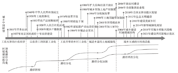
2.2.1 工农互补的小农经济阶段
传统乡土中国时期,在人多地少的客观自然条件约束下形成了男耕女织、工农互补的小农社会经济形态。由于村庄内部可以自给自足,具有清晰稳定的地域界限,相对独立封闭,人际关系以血缘、地缘为主,因此社会关系稳定,造就了以乡绅、宗族自治为主的分散权力格局。就城乡关系来看,这一时期乡村孕育着城市,城市还未形成独立于农业的“城市文明”[1]。城市主要职能为行政与军事,用来管理和预防农村地区孕育的抗争,此外还承担商业功能,为周边农村地区提供商品交换的场所。城市内的居民也并没有真正脱离土地,还处于乡村的社会网络当中。
此时,各区域村镇建设格局的差异主要源自居民对其所处自然环境的利用及改造[26]。往往可从聚落的命名中看出,村镇的形成遵循“风水”等古代人居思想,其规模、形态与其所处的自然环境关系密切,形成了条带状、指状、团状等形态。此外,“择田而居”的生产生活关系造就了聚落分散的分布格局。但由于社会经济结构相似,因此在相同的动力机制作用下,村镇建设格局演化缓慢且路径一致。
2.2.2 以农养工的国家工业化阶段
1949年中华人民共和国成立后,受限于内忧外患的发展局势,中央政府制定了快速建立工业化体系的发展战略,通过计划经济体制下的工农产品剪刀差为国家工业化提供资本原始积累。在此期间,国家通过农村土地集体化自上而下重构了乡绅自治的权力格局,建立了人民公社,形成“三级所有、队为基础”的生产模式,生产队取代家庭成为新的基本生产单位,传统乡村社会结构走向消解。同时,城乡二元制度的设立将各类生产要素缚之于土,资源以计划的方式进行配置,构成了典型的城乡二元社会经济结构。各类要素难以在城乡之间自由流动和迁移,致使乡村向现代社会转型进程受阻,缺失了发展的动力与活力。
此时,作为城乡建设的唯一投资人,国家权力占据了空间生产的主导地位,村镇建设格局在行政力量的塑形下按照人民公社规划的蓝图方向演化,快速重构且路径一致。为服务农业生产的国家战略需求,作为农产品供给端的乡村空间,土地利用要求适应于新的生产关系,以划分耕作区配置居民点的方式构建“人民公社生产综合体”,分散的村镇建设格局开始统一转向依靠河网兼顾耕作半径的均衡分布模式[27]。
2.2.3 工农并举的乡村工业化阶段
乡村工业化引发村镇建设格局分化出适应于工业生产的演化路径。部分社队企业基础较好的乡村地区在市场化经济的推动下自发开始建设小城镇,人口、土地等各类要素从农业部门向非农部门转移。为方便工业生产和交通运输,村镇沿河流和公路粗放、外延式扩张,形成了沿交通轴线渐进式扩散的点轴式空间组织模式[30]。但由于此时缺乏规划管控,导致耕地快速非农化、产业同质化,带来了资源低效利用、基础设施重复建设及环境严重污损等问题。
2.2.4 城进乡退的土地城镇化阶段
20世纪90年代,全球化带来的资本快速流动引致土地要素供需活跃,国家依靠建立城乡双轨土地产权制度及用途管制制度,加强了对空间的控制。分税制改革激发了地方政府经营土地、经营城市的积极性[31]。但仅有部分沿海地区市县得益于开放战略、区域差异性的体制环境率先崛起,凭借成本优势参与到全球生产网络当中,吸引了较多外资进驻,形成新的制造业空间。而中西部地区则频繁出现土地城镇化快于人口和产业集中的空城、鬼城现象。内地农民开始大规模跨省份、跨地区流动打工,人口流失导致乡村治理组织的弱化,东西部地区差距、城乡差距日益扩大。
土地城镇化进一步加剧了县域间村镇建设格局演化路径的分化。资本与权力相结合的“增长”联盟开启了以土地财政为主导的“以地谋发展”发展模式,导致城乡空间快速重构[32]。地方政府一方面在乡村空间低价征收集体土地,并通过合村并居的方式推进农民集中居住,另一方面将集中居住获得的节余建设用地指标用于建设新城、开发区,以高价出让商住用地、低价出让工业用地的方式扩展城镇空间。在此过程中,乡村劳动力、土地等要素单向流入城市,村庄快速消亡,城镇无序扩张,城乡建设呈两极分化态势。
2.2.5 城乡互动的空间商品化阶段
概而言之,城乡中国转型过程中,乡村社会经济形态先后经历了从早期自给自足的小农经济到计划经济再到市场经济的转变,资本与权力在不同阶段都以其独特的方式介入了村镇建设格局的“生产”。在当前市场经济条件下,受国家引导、政府干预、市场介入、居民日常生活等多行为主体交互的共同影响,各县域村镇依据其特有的比较优势参与到了市场交换过程当中,逐步形成了以农业生产、工业生产及消费服务供给等为主的发展路径。村镇建设格局作为社会经济形态的空间表现形式,嬗变分化形成多元化的演化路径,即不同县域的城、镇、村在专业化、分工、协作和交换过程中呈现出差异化的发展态势。下文将通过对比典型案例区的村镇建设格局演化过程,揭示其时空特征及影响因素作用机制差异。
3 研究区概况与数据来源
3.1 研究区概况与典型县域选择
江苏省位于长江三角洲地区,东部濒临黄海,地形以平原为主,水网密集,自然本底条件差异较小。江苏自古就是中国的主要粮食种植区,农业发展条件优越,同时还拥有繁荣的商业及发达的手工业,改革开放后,在快速工业化过程中形成了全国范围较大规模的制造业集群。江苏省城镇化水平、经济发展均走在全国前列,但省域内部仍存在南北梯度性差异。为促进区域协调发展,江苏近年来开展了县域之间城乡建设用地增减挂钩(简称挂钩)节余指标交易流转等相关工作,推动资源优化配置,进一步显化了市场资本与行政力量对村镇建设格局的形塑作用。
县域是中国经济发展和空间治理的基本单元,具有完整的城乡聚落体系。因此本文选取江苏省灌云县、昆山市、高淳区作为案例区(图2),其中昆山1989年撤县建市,高淳2013年撤县设区。虽三者分别为县、县级市、以及市辖区,但都属于县级行政区,同时3个案例区乡村社会经济活动分别以农业生产、工业生产及旅游消费为主,与城市形成了产品互补、要素互补、空间互补的共同富裕实现路径,具有典型的代表性,因而非常具有比较研究价值。本文通过对比分析三者村镇建设格局演化时空特征及影响因素作用机制差异,旨在从中找出其演变过程的一般规律和特征,理解社会形态变迁对于村镇建设格局演化的具体影响。
图2
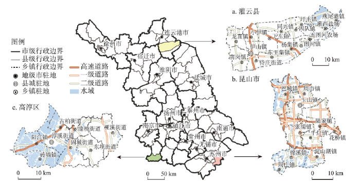
灌云县地处黄泛平原区(图2a),地势平坦,除分布有孤岛状低山残丘,其余均为海陆交互沉积的滨海平原。县域面积1538 km2,其中1200 km2为农用地,占全域面积80%,整体耕作条件良好,年均粮食产量80万t以上,是国家重要的粮食主产区。2018年灌云县城镇化率为50.92%,农业就业人口占乡村就业人口比例为50.05%,农业生产综合机械化水平达86%,获得了全国粮食生产先进县称号,具有传统农区发展的典型特征。
昆山市地处长江三角洲太湖平原(图2b),全域范围931 km2,东依上海,西邻苏州。昆山市1985年便自发建立了“工业新区”,1992年被批准成为国家级开发区,通过引进外资逐步形成了“一镇一园区”的分布格局,当前已成为国际生产链的重要节点。与之相伴的是建设用地不断扩张,2020年昆山市开发强度达到44.7%,常驻人口城镇化率达到78.96%,远超全国平均水平。在此过程中,大量村庄改制为社区,村庄用地上盖起了厂房,空间转型推动乡村居民地缘、业缘和血缘关系不断重构,农业就业人口仅占乡村就业人口7%,而工业就业人口占比高达61%。从这个意义上说,昆山市是乡村就地工业化转型发展的典型例子。
高淳区地处南京远郊(图2c),全域范围790.23 km2,具有良好的生态景观,境内东部为低山丘陵风貌,西部为水网圩区景观。多年来高淳区政府秉承“生态立县”的发展理念,推动乡村向以休闲、旅游、康养为主的新业态转型,通过资源整合形成全域旅游发展态势,2010年其境内一条全长48 km涉及6个行政村的桠溪“生态之旅”景观廊道被授予了“国际慢城”称号。2018年高淳区常住人口城镇化率达到61.22%,乡村就业人口当中农业仅占比18%。综合来看,高淳区是乡村生态旅游转型发展的典型案例。
3.2 研究方法与数据来源
本文着重对比不同发展路径下的县域村镇建设格局演化差异,因此研究时段主要选取在案例区村镇发展路径基本形成之后。同时综合考虑数据的可获取性及可比性,本文选取2009—2018年作为研究时段,基于2009年与2018年两期土地利用调查数据,从城镇村的规模结构、空间布局、用地形态及功能变化3个方面进行对比分析。其中,村镇规模结构演化由不同用地类型相互之间转换得到,其中城关镇、建制镇、村庄规模分别与土地利用调查用地分类中的城市(地类代码201)、城镇(地类代码202)、村庄(地类代码203)用地面积所对应。村镇空间布局演化通过构建格网汇总变化的村镇用地得到,计算莫兰指数度量其分布模式,并以0.5个标准差分级进行可视化展示。由于3个县域行政区域面积有所差异,本文在多次比较后确定灌云县、昆山市与高淳区分别采用1000 m2、500 m2、500 m2网格作为分析及可视化尺度。村镇用地功能及形态演化借助天地图影像进行人工识别,选取典型变化地块进行描述分析。此外,为了进一步明晰村镇建设格局演化过程中影响因素的作用机制,笔者团队还对案例区的相关政府文件资料进行了梳理,并多次前往实地考察,对当地居民、政府官员等行为主体开展访谈。
4 典型县域村镇建设格局演化对比分析
4.1 典型县域村镇建设格局演化时空特征
4.1.1 规模结构演化
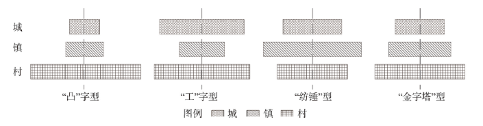
2009—2018年灌云县、昆山市和高淳区城镇村规模结构流向及变化幅度具有显著差异,但共同表现为城镇规模扩张以及村庄规模收缩(图3)。乡土中国时期,乡村地区孕育出了城镇,城镇村规模结构可以看作为“凸”字型(图4),即村庄规模远大于城镇。随着社会经济结构转型,不同发展路径下的县域城镇村规模结构走向分化。灌云县村镇规模结构变化幅度较小,其中城关镇规模大幅增加65.23%(945.52 hm2),村庄规模减少3.35%(461.32 hm2),城镇村趋于形成“工”字型规模结构。昆山市村镇规模结构变化最为剧烈,城关镇在经历了早期扩张后规模已较为稳定,建制镇规模大幅增加32%(4932.00 hm2),村庄用地规模减少1132.82 hm2,新增670.74 hm2,总规模减少8%,规模结构演化趋向于“纺锤”型。高淳区城关镇与建制镇规模增幅分别为1389.80 hm2与1408.07 hm2,村庄规模大幅减少23%(1679.57 hm2),城镇村规模结构向“金字塔”型演化。
图3
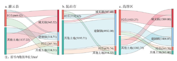
图3
2009—2018年3个县域村镇规模结构流向
Fig. 3
The scale structure of town-villages flow in the three counties from 2009 to 2018
图4
4.1.2 空间布局演化
研究期内,3个县域新增与减少的村镇建设用地分布的Global Moran's I均为正数(表1),且都通过了显著性水平检验。这表明案例区村镇建设用地变化空间集聚特征明显,但聚集程度存在差异。灌云县、昆山市、高淳区分别呈现“新增集聚、减少分散”“新增分散、减少集聚”“新增集聚、减少集聚”的空间分布特征(图5)。具体而言,① 灌云县新增建设用地集中分布于城关镇以及相邻的经济开发区,呈圈层状扩展,而其余建制镇仅有少量斑块状新增用地。减少的村镇用地零散分布于县域乡村腹地,主要为各乡镇行政区边缘及远离道路的区域。② 昆山市村镇用地呈现以城关镇和东南方向的上海市为两个大中心圈层状扩展,同时又以各建制镇驻地为小中心组团式扩展。减少的村镇用地较多位于县域边缘地区以及新增用地热点区域。③ 高淳区新增用地集中于城关镇与其相邻的开发区,沿省道轴线扩展。此外还有部分点状新增用地分布于国际慢城风景区周边的乡村地区。减少的村镇用地主要位于东南部的付家坛公益林生态保护区,以及东部的丘陵地区。
表1 2009—2018年3个县域变化村镇用地分布莫兰指数
Tab. 1
| 变化类型 | 案例区 | Moran's I | Z得分 | P值 |
|---|---|---|---|---|
| 新增村镇用地 | 灌云县 | 0.53 | 31.26 | < 0.001 |
| 昆山市 | 0.46 | 40.04 | < 0.001 | |
| 高淳区 | 0.55 | 44.27 | < 0.001 | |
| 减少村镇用地 | 灌云县 | 0.14 | 8.02 | < 0.001 |
| 昆山市 | 0.23 | 20.61 | < 0.001 | |
| 高淳区 | 0.28 | 22.65 | < 0.001 |
图5
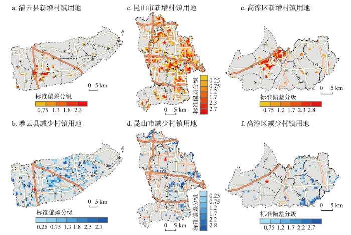
图5
2009—2018年3个县域村镇变化用地的空间格局
Fig. 5
The spatial pattern of town-villages change land in the three counties from 2009 to 2018
4.1.3 形态及功能演化
研究期内,3个县域新增与减少的村镇用地形态及功能也存在显著差异(图6)。① 灌云县城关镇新增用地主要用于服装纺织等劳动密集型制造业,空间形态较为松散,仍有部分闲置土地。建制镇新增用地主要用于新建农村社区,空间形态表现为布局紧凑、形制规整的联排式住房。村庄用地功能仍以居住为主,新建的双层自建房沿道路扩张,村庄内部的闲置地块被逐步复垦。② 昆山市城镇新增用地主要为工业及商住用地。其中,城关镇以产业园区的形式进行成片开发,主要为电子信息产业等高新技术制造业,而建制镇则主要为中小型配件制造业的用地填充式扩张。村庄用地形态发生了转变,原条带状的村庄被集中连片复垦,取而代之的是高密度垂直邻近的多层楼房。③ 高淳区城关镇新增用地主要为工业用地,而建制镇则以住宅用地为主。村庄用地功能发生了转型,位于景观区的村庄由单一居住功能向旅游休闲、餐饮住宿多功能复合转变,而位于付家坛公益林区域内的村庄则被集中连片复垦。
图6
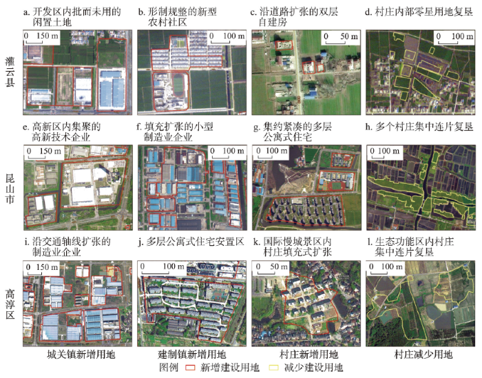
图6
2009—2018年3个县域村镇变化用地典型地块的形态及功能
Fig. 6
The form and function of typical plots in town-villages change land in the three counties from 2009 to 2018
4.2 典型县域村镇建设格局演化影响因素作用机制
村镇建设格局是多种要素在长时间尺度、多空间层次耦合作用的结果,在演化过程中受到自然环境、区位交通、产业经济和行政管制多种因素的相互作用影响(图7)。其中,自然环境奠定了村镇建设的初始格局,在演化过程中充当限制性角色,例如地形地貌及资源禀赋约束其形态及规模。随着科学技术的不断进步,自然环境约束力不断减弱,村镇建设选址由最初的安全导向逐步转向追求公共服务以及非农就业机会,城镇与道路引导着村镇集聚的方向。此外,在产业结构变迁过程中,非农产业将逐步从城镇中心极向乡村腹地溢出,带动村镇用地功能转型。为适应社会经济发展,政府也会采用制度政策、空间规划等行政管制手段干预调控村镇建设格局。
图7
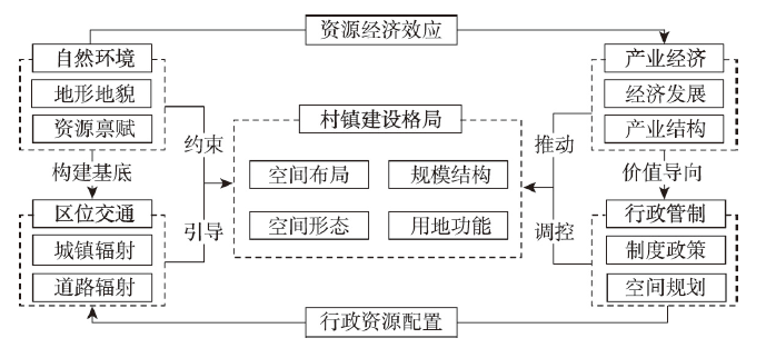
图7
村镇建设格局演化影响因素作用机制
Fig. 7
The mechanism of influencing factors for TVCP evolution
灌云县村镇建设格局受区位交通及行政管制影响显著。灌云县域整体地势平坦且耕作条件良好,因此村镇建设受自然环境限制较少,逐步形成了以耕作距离为半径的分布格局,以及团块状的空间形态。在城镇化进程中,村镇建设呈现明显的区位交通指向,乡村地区居民为获取更方便的公共服务和非农兼业机会,选择沿交通干道轴线新建住房,原村落逐渐空心化。近年来江苏省大力开展苏北农房改善工作,灌云县政府通过与其他市县交易挂钩节余指标换取资金,在建制镇周边建设新型农村社区。但由于灌云县乡村人口生计仍对农业依存度较高,同时政府财政资金不足以支撑大规模的整村拆迁撤并,因此仅复垦了交通可达性较差的村庄内部零星闲置用地。总体而言,灌云县村镇建设格局演化延续既有路径,未有大规模突变性调整。
昆山市村镇建设格局演化受产业经济与行政管制因素主导。昆山市早期通过与上海的国营企业建立生产协作关系,实现了“农转工”的第一次产业结构转型。在改革开放后,地方政府又大力发展外向型经济,引进台资组建跨境生产网络,形成了大规模的电子信息产业集群。随后,德资与日资等外来的资金、技术进一步推动昆山产业结构升级,发展现代服务业、高新技术制造业等产业,以产业园区的形式不断推动城关镇空间拓展与更新。随着产业升级,相关配套制造业开始向周边建制镇扩散,逐渐形成了“一镇一园区”的空间格局。土地资源在此背景下日益紧缺,市、镇两级政府一方面以推进农民集中居住的方式取得节余指标,另一方面以每亩(1亩≈666.7 m2)高达66万元的价格从其他县市购买“土地指标”。尽管早期水网密布的地理环境塑造了村庄条带状空间形态,但限制性逐渐减弱。在货币化补偿或商品房置换的政策推动下,村庄居民搬入了形态规则的社区集中居住并转向非农就业,农用地大规模流转进入农地股份专业合作社。与此同时,由于外来务工人口的大量涌入,当地居民发展起了“房东经济”,收入迅速提高,为追求更好的公共服务及住房需求迁往城关镇或建制镇。
高淳区村镇建设格局演化受其所处的自然环境及行政管制影响较为显著。与其他两县相比,高淳区地形复杂,东部丘陵山地破碎的地形极大限制了村镇的集聚和扩张,西部纵横的河网圩区塑造了村镇条带状的空间形态。因其自然环境优越,地方政府在早期确立了“生态立县”的发展思路后,便集中整改了旧有的污染企业,并限制了桠溪街道的用地项目,后期又设立了国际慢城管委会进行全域旅游发展规划,对具有良好自然景观的村庄进行空间形态改造、农家乐扶持等政策性帮扶。在此过程中,景域集团、中农国信控股等社会市场资本也开始介入国际慢城营造,投资建设各类基础设施。当地居民也逐渐由外出打工转为回乡创业,参与创办民宿与农家乐分享增值收益。各类资源要素的集中配置使得部分坐落在丘陵深处的欠发达村落转变为特色旅游村,村庄的规模有所扩大,用地功能也随之转型。而另一边,位于付家坛公益林保护区内的多个自然村则被政府集中搬迁撤出,村民被迁往东坝镇集中安置,对村镇建设格局产生了突变性影响。
综上,3个县域在不同发展路径下由于土地、人口、产业等要素集聚与疏散的空间需求不同,其村镇建设格局演化时空特征及影响因素作用机制具有明显的差异(表2)。
表2 案例区县域村镇建设格局演化对比分析
Tab. 2
| 县域 | 时空特征 | 主导影响因素及作用机制 | ||||
|---|---|---|---|---|---|---|
| 规模结构 | 空间分布 | 用地形态及功能 | 主导影响因素 | 作用方向 | ||
| 灌云县 | “工”字型 | 新增集聚、减少分散 | 用地形态向精明收缩转型 | 区位交通、行政管制 | 村镇布局及形态 | |
| 昆山市 | “纺锤”型 | 新增分散、减少集聚 | 用地形态向集约有序转型 | 产业经济、行政管制 | 村镇规模及形态 | |
| 高淳区 | “金字塔”型 | 新增集聚、减少集聚 | 用地功能向多功能复合转型 | 自然环境、行政管制 | 村镇布局及用地功能 | |
5 村镇建设格局差异化演化模式
对比分析结果表明,在不同发展路径下的县域形成了差异化的村镇建设格局演化模式。从宏观上看,其演化是不同权力与资本结构运作规律在县域尺度的映射,从微观上看,是各行动主体在每一个地块上抵抗、积累与发展的博弈结果。城镇化、工业化、全球化、现代化所带来的空间使用需求转变是演化模式分化的前提。各县域的地理环境是造成模式分化的内生动力,资源禀赋及地理区位作为空间的固有属性,具备满足特定使用需求的级差地租及垄断地租,因此基于比较优势强化了劳动地域分工,逐步塑造了特定社会形态。权力与资本形成的“增长联盟”是模式分化过程的重要外部推力,其中,资本追求剩余价值的本质,使其借助对物质环境的建设和改造来加快自身积累,权力为争取各类生产要素在本地停留,通过行政调控手段构建有助于资本循环的制度环境空间,从而对资本的积累和流动进行控制。两者相结合共同加速了空间组织模式的生产,使其适应于特定社会形态下的要素流动需求。在此反复形塑过程中,形成了各类具有一定普适意义的县域村镇建设格局演化模式(图8)。本文基于案例分析结果归纳总结了农业生产型、工业生产型以及生态消费型3类演化模式。
图8
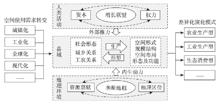
5.1 农业生产型演化模式
中国大部分县域处于发展的“边缘地区”,产业结构层次较低且城乡收入差距较大。此类县域城乡要素流动泾渭分明,其中城镇聚集工商业活动,空间形态较为规整,以楼房、厂房为主,而乡村地区未经历剧烈的转型重构,社会经济结构仍以农业为主,聚落散布在农田当中,其演化模式为农业生产型(图9a)。
图9
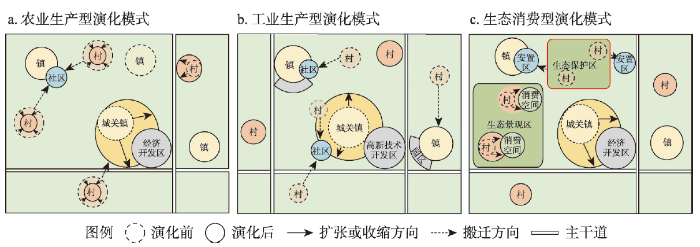
该演化模式呈城关镇极化扩张与村庄精明收缩的两极分化态势,动力机制为行政力量及社会需求推动的城镇化。城关镇是传统农区县域范围内资本循环与乡村居民搬迁的首要选择。地方政府通过投入大量财政资金及政策优惠,构建生产性建成环境(经济开发区)吸引市场资本进驻,形成城关镇单核心的极化扩张态势。建制镇主要承担乡村地区公共服务供给及农业技术支持功能,在交通逐渐便利、出行范围扩大背景下,公共资源在撤乡并镇过程中被进一步集中配置,建制镇规模稳定但数量逐渐减少。农业生产的季节性导致了全年劳动力需求极不均衡,但由于此类县域乡村地区未有足够的兼业机会,部分乡村居民为更便捷获取公共服务及非农就业机会,从而选择搬入城镇或在道路沿线新建住房,原村落日渐空心化。地方政府在挂钩政策的激励下,复垦村庄内部闲置用地换取资本与新增建设用地指标,并将其投入开发区与新农村社区的建设当中,县域范围内村庄呈现精明收缩态势。
近年来,伴随发达地区产业向欠发达地区转移,农民工逐渐呈现回流趋势[38]。但由于其常年闲置的宅基地无法进行市场化交换,转换为进城的资本,因此部分回流农民工成为了摆动的城乡“双栖”人口。本文认为,如何顺应回流趋势推进以县城为重要载体的城镇化建设,是此类地区面临的主要问题,这也是制定“十四五”规划建议当中所提及的关键方向。此类县域城乡融合发展应首要关注基本公共服务均等化。公共服务供给端方面,进一步加强城关镇对于乡村腹地居民的吸引力,通过承接发达地区劳动密集型产业吸纳农业剩余劳动力,同时可让渡部分土地发展权换取财政资金,优先用于改善县域范围的公共服务及交通基础设施条件。公共服务需求端方面,应适度优化村镇体系促进人口集聚,兼顾农业耕作及公共服务获取两个半径来配置重点镇、中心村(社区),同时探索创新土地流转及宅基地退出等方式作为优化村镇建设格局保障机制[39]。
5.2 工业生产型演化模式
现代信息通讯以及交通运输的发展带来了经济全球化,位于沿海地区发展走廊的县域有机会凭借其优良的区位条件及大量剩余劳动力跃迁为全球生产网络中的一个节点。在大量资本进驻当地投入生产性物质环境建设的过程中,此类县域在空间上经历了快速的“三集中”,即企业向工业园区集中、村庄向中心社区集中、农地向专业合作社集中,形成了工业生产型村镇建设格局演化模式(图9b)。
该演化模式下乡村土地、人口等要素快速、单向流入城镇,呈现建制镇多中心扩张及村庄集中撤并态势,动力机制为市场经济与行政力量结合推动的城乡空间剧烈重构。具体而言,城关镇在资本循环推动下进行内部空间更新,经历更为剧烈的改建、重建,以提高土地的交换价值。例如开发商品房发展房地产市场,或设立高新技术产业园区促进产业结构升级。在土地成本价格的巨大势差下,低端配套制造业向乡村地区转移促使建制镇规模扩张,农业生产空间被转换为新的制造业空间。由于土地资源紧缺,村庄在“增减挂钩”的运行机制下被集中连片复垦,其土地发展权被转移到城镇,乡村居民被地方政府以货币化等补偿方式安置到城镇社区居住。
此类地区在快速城镇化过程中,当地农民主动或被动地脱离了与土地的关系,搬入了现代化的城市社区。与此同时,外来人口的大量涌入,进一步打破了以血缘、地缘为主的传统熟人社会,转变为业缘主导的陌生人社会。因此,面临的问题不仅有空间冲突矛盾,如建设用地的无序扩张、低端产业的环境污染等,还有人的城镇化滞后于土地、户籍城镇化等问题,即农民在城市适应性与现代性的获得中,缺乏基本的心理过渡和弹性,产生自我认同危机[40]。在未来城乡融合发展中应关注农业转移人口市民化,实现真正以人为核心的高质量城镇化。一方面转向关注空间品质提升,合理规划组织产业集群,驱动县域经济高质量发展,避免乡镇之间重复低效建设以及建设用地无序蔓延扩张。另一方面除住房与货币化补偿外应给予更多非农就业培训及安置机会,以业缘为引导促进农业转移人口在生活、文化等方面融入城市生活。
5.3 生态消费型演化模式
部分县域乡村空间因拥有良好的人居环境、自然景观与乡土文化,在快速城镇化过程中逐渐体现出旅游、康养、休闲、教育等商业价值,例如亲子乐园、农家体验等都是以消费“空间商品”的方式进行乡村经济重建的具体事例。村镇通过提供消费服务供城市居民休憩、游玩,进而被纳入到城市主导的消费体系,在权力与资本对其空间形式的投入与改造过程中,逐步形成生态消费型演化模式(图9c)。
生态消费型演化模式的城关镇与建制镇演化态势与农业生产型相似,其显著特点在于以村庄为基本单位在空间商品化与权威化推动下呈现复兴或消亡的分野态势。乡村空间商品化本质是,为分享生态环境与自然景观的增值收益,资本通过投入消费性物质环境建设及营造,以垄断地租的形式攫取空间剩余价值。生态空间权威化是指,具有重要生态系统服务功能的区域被政府公权力划定为不具备土地发展权的“权威空间”,即生态保护区。生态保护红线划定的最初目的,是作为自然资源利用监管的空间权威形式,促进地方经济发展与资源环境相均衡。但在实践过程中,部分地方政府往往将生态保护所赋予的干预地方村庄的权力用于经营地方发展,如利用生态移民来加快城市化进程[41]。从空间视角来看,位于生态景观区的村庄因具有潜在的商业价值,吸引资本入驻营造消费空间并将其马赛克式地镶嵌在乡村原有的空间肌理之上,从而呈现复兴扩张态势;而位于生态保护区的村庄则因丧失土地发展权,被地方政府从空间上“抹除”,村庄居民也被迁往城镇或主干道旁的新建安置社区。
此类地区在向消费、休闲等多功能复合转型过程中需谨防乡村空间异化。生态康养、观光农业等消费空间的营造势必会挤压农业生产空间,造成耕地“非农化”“非粮化”的潜在风险。此外,地方政府、市场资本、社会精英对乡村空间的不同理解使其成为多种力量角逐的场所,忽视了日常生活居民的权利。在此过程中,村庄不仅在物质形态上经历了剧烈改造,社会空间也会产生分化,形成阶层隔离和社群边界[42]。因此该模式推进城乡融合发展更应关注城乡之间的业态协同互补,以及乡村空间的一二三产有机融合,通过构建可持续的城乡要素流通路径使资本为乡村注入活力,而非一味地将城市商业的运作逻辑复制到乡村空间。其次,生态治理模式应构筑多元主体参与的组织格局,这也是践行“两山论”自然观的关键所在。通过积极探索生态产品的市场价值实现机制,激励当地居民及社会资本参与对生态环境和地域文化的保护,而不是简单采用划定保护红线的方式将生态空间“权威化”,使之成为无人区。
6 结论与讨论
6.1 结论
中国历经百年转型发展与变迁,已告别传统意义上的乡土中国步入城乡中国阶段,在此过程中村镇呈现异质化发展态势。本文基于“社会过程—空间形式”视角,剖析了村镇建设格局演化路径分化逻辑及历程,并选取江苏省典型县域对比分析其村镇建设格局演化差异,将其演化态势、动力机制归纳总结为具有普适意义的演化模式。研究发现:
(1)村镇建设格局演化是典型的空间生产过程,社会形态变迁引发村镇建设格局演化路径呈现多元分化。在城乡中国转型过程中,乡村社会经济形态先后经历了从早期生存经济到计划经济再向市场经济的转变,资本与权力在不同阶段都以不同的方式介入了村镇空间生产。在当前市场经济条件下,部分县域村镇依据其特有的比较优势参与市场交换,逐步形成了以农业生产、工业生产及旅游消费为主的3种发展路径。生产方式转变引致县域间村镇建设格局演化路径也相应发生分化,形成了不同于乡土中国时期囿于自然环境所引起的差异。
(2)在不同的发展路径下,各县域村镇建设格局演化时空特征、影响因素作用机制存在显著差异。城镇化、工业化、全球化、现代化带来的要素集聚与疏散的空间需求转变,是演化模式分化的前提。县域之间的地理环境差异形成了垄断地租,是演化模式分化的内生动力。资本与权力结合形成的“增长联盟”是模式分化过程的重要外部推力,以竞争为导向的积累制度加剧了模式分化。在此过程中,各行动主体在每一个地块上抵抗、积累与发展的博弈结果,造就了差异化的村镇建设格局演化模式。
(3)与现实发展相比,本文提出的3类县域村镇建设格局演化模式在中国具有一定的代表性:农业生产型演化模式呈城关镇极化扩张与村庄精明收缩的两极分化态势,动力机制为行政力量与社会需求共同推动的城镇化;工业生产型演化模式呈建制镇多中心扩张与村庄集中撤并态势,为市场力量主导的资本快速循环所推动;生态消费型演化模式的特征在于,县域村庄在空间商品化与权威化的推动下呈现复兴或消亡的分野态势。面对差异化的演化态势及动力机制,本文认为3类模式应分别以基本公共服务均等化、农业转移人口市民化、城乡业态协同化作为推进城乡共同富裕、融合发展的切入点。
6.2 讨论
实现城乡共同富裕的根本道路是提高生产力,进而达成城乡各美其美、美美与共的融合发展。乡村空间作为农产品与生态产品的提供者,具有城市无法代替的功能,但地方政府在长期经济增长导向下形成了城市政府思维,在县域发展过程中重视“经营城市”“经营土地”,而忽略了乡村的生态、文化等价值。本文选择的3个案例区凭借自身资源禀赋和区位条件优势,分别以提供农产品、土地要素、游憩空间作为村镇发展路径,形成了城乡产品互补、要素互补、空间互补的融合发展态势。从全国范围来看,以上述3类互补发展作为实现城乡共同富裕的路径已初步形成,例如山东寿光蔬菜基地、广东南海村镇工业集聚区、浙江安吉乡村生态旅游等,2019年寿光市、南海区、安吉县的城乡收入比分别达到1.92、1.75、1.70,均低于全国平均水平2.64。因此,本文基于这3类典型县域对村镇建设格局演化进行比较研究,剖析其背后社会经济形态变迁下的资本与权力运作机制,对其他地区村镇发展及空间规划具有一定启示意义。
中国地理环境与社会经济的复杂性共同决定了村镇建设格局的多样性[43]。部分地区盲目推行合村并居引发基层治理矛盾表明,当前对于村镇建设格局演化的客观规律认知仍滞后于现实实践需要,忽视当地社会经济形态的大拆大建式物质空间改造,必然难以适应当地居民的生产生活需求。需要认识到,城乡中国社会形态将是今后中国相当长时期所处的一个阶段[1],在此阶段亟需构建城乡统筹的空间治理体系,因地制宜构筑适应于不同要素流动需求的村镇建设格局。首先,应通过村镇资源环境承载力评价,探寻村镇比较优势,明确村镇发展的主导功能,从而设立差异化的村镇空间用途管控细则,因势利导指引村镇空间开发利用。其次,以土地综合整治与生态修复为抓手优化村镇空间布局,针对人口生计依然对农业依赖程度较高的村庄,可通过腾退闲置宅基地对村庄内部结构优化调整,以改善村庄人居环境为主。而以现代化农业或非农就业为主的村镇,则可在一定地域单元范围内进行村镇体系优化。例如,依据耕作半径集聚农村聚落,依托交通轴线培育乡村产业集群,通过景观廊道串联传统村落,在实现相对集中居住的同时,有效整合土地、景观等空间资源,以此促进村镇发展。最后,为充分发挥村镇比较优势,还应进一步推进要素市场化配置。通过完善乡村地区的土地发展权、碳汇权益等市场化交易机制,建立城乡统一的建设用地市场,以及探索生态产品价值的实现路径,来提高乡村居民财富保有量和财产性收入,为实现城乡共同富裕提供支撑。
近年来在土地整治的推动下,乡村空间经历了剧烈重构,农村居民点已由无序扩张转向精明收缩态势。相比基于多期遥感影像解译的乡村聚落演变研究,本文采用的土地利用变更调查数据精度较高,结合高分辨率的天地图影像可进一步揭示村镇变化地块的形态及功能,更有效地支撑精细化乡村空间治理。同时本文研究成果也对现有文献进行了补充。如李智等[15]根据城乡发展水平将县域划分为发达、中等发达、欠发达3种类型,分别选取典型县域对比分析了三者的城乡聚落演化过程,部分研究结果与本文具有一致性,即其文中的欠发达、发达县域的城乡聚落规模演化过程,与本文传统农区灌云县、工业强县昆山市相似。但当欠发达县域的城乡发展水平步入发达阶段后,其村镇建设格局是否一定会相应转型为发达县域演化模式?本文认为特定演化模式来自于要素集聚与疏散的空间需求不同,是由村镇发展路径所决定的。因此,在村镇差异化发展态势下,基于发展路径视角对村镇建设格局演化进行分类探讨更为合理。
此外,本文也存在有一定局限性。村镇建设格局演化在不同阶段具有差异化特征,本文受限于研究数据的可比性,仅对比分析了案例区2009—2018年间村镇建设格局演变特征,未能涵盖其转型过程。其次,同一模式下仍存在多类亚模式有待进一步比较,例如,在村社集体组织力量较强的珠三角地区,村镇建设格局同样经历较快的工业化进程,但其演化模式不同于行政力量为主导的地区。在村镇异质化发展背景下,后续研究应及时归纳总结新生的村镇发展路径及相应的空间组织模式,尝试借助地理时空大数据解析城乡要素流动规律,定量化识别影响因素的显著程度及作用机制,探讨乡村重构过程中不同主体之间的博弈关系、权力与资本的运作机制,为推进乡村聚落地理学做出具有创新性的成果,有针对性地支撑村镇建设格局优化调控决策。
参考文献
From native rural China to urban-rural China: The rural transition perspective of China transformation
从乡土中国到城乡中国: 中国转型的乡村变迁视角
Rural restructuring: Theory, approach and research prospect
DOI:10.11821/dlxb201704001
[本文引用: 1]

For the sake of adapting to the changes of elements in both kernel system and external system of rural development, rural restructuring is a process of optimally allocating and efficiently managing the material and non-material elements affecting rural development, reshaping social and economic structures in rural areas and optimizing spatial pattern in rural territory, and approaching the structure optimization and function promotion of rural territorial system as well as the structure coordination and function complementation of urban-rural territorial system. Based on elaborating the concept and connotations of rural restructuring and the mechanism of promoting rural restructuring due to the evolution of "elements-structure-function", the paper probed the approaches of rural restructuring from the aspects of spatial restructuring, economic restructuring and social restructuring. In order to meet the current national strategic demands and meet the challenges of rural development in the process of urban-rural development transformation, it is in great urgency to strengthen the study on the patterns and processes, dynamic mechanism, differentiated development models, rural planning technology systems, strategies and policies for rural development, and the impacts of globalization on China's rural restructuring in the future. Finally, focusing on a series of problems in the implementation of some important government intervention policies, which is aimed at boosting the social and economic development of rural areas in recent years, a critical analysis and discussion is carried out.
论乡村重构
DOI:10.11821/dlxb201704001
[本文引用: 1]
快速城镇化进程驱动中国乡村地域发生巨大变化。乡村重构,即为适应乡村内部要素和外部调控的变化,通过优化配置和有效管理影响乡村发展的物质和非物质要素,重构乡村社会经济形态和优化地域空间格局,以实现乡村地域系统内部结构优化、功能提升以及城乡地域系统之间结构协调、功能互补的过程。本文在界定乡村重构的概念内涵,构建基于“要素—结构—功能”演变助推乡村重构的理论框架基础上,从空间重构、经济重构、社会重构视角探讨了乡村重构的实现路径,并着眼于服务当前国家重大战略需求和解决城乡转型发展进程中乡村地域系统面临的现实困境,提出了未来中国乡村重构研究需重点关注的内容。最后,就现有旨在促进乡村社会经济发展的重大引导性战略和政府干预性政策及其在实践操作中引发的一系列问题,展开批判性分析和讨论。
Differentiation of rural development driven by industrialization and urbanization in eastern coastal China
DOI:10.1016/j.habitatint.2009.03.003 URL [本文引用: 1]
Detecting the pathways towards rural vitalization from the perspective of territorial functions in Jiangsu province
DOI:10.11821/dlyj020180919
[本文引用: 1]
Detecting a pathway towards rural vitalization has drawn considerable attentions from both governments and scholars in China within the context of rural restructuring. Given that territorial functions of rural areas varies cross the country, it is essential to clarify the spatial pattern of territorial functions for demystifying the model and pathway of rural development. Taking Jiangsu - one of the most developed provinces in eastern China - as an example, this paper proposes an indicator system for rural territorial function covering triple dimensions of economic development, life support, and ecological conservation. Thereafter, we conduct an empirical study at the county and district level followed by a discussion about potential pathways towards the vitalization of villages in different zones. The findings imply that: 1) the function of economic development in rural Jiangsu is not as good as expected, and the degree of spatial agglomeration is relatively low. Coincidently, the pattern of life support is consistent with that of economic development, which is regarded as a trend of gradual decline from south to north. Few districts or counties can be detected with high values of ecological conservation, which suggests an urgent demand for sustainable development in rural Jiangsu. 2) Taking the spatial heterogeneity of rural areas in respect of their overall functions into consideration, we further divide the province into four zones, namely primarily developed zone, optimized developing zone, transformation zone, and lagging underdeveloped zone. Finally, we put forward some suggestions for rural vitalization in the aforementioned functional zones, and argue that rural revitalization is a long-term project that cannot be done overnight.
江苏省乡村地域功能与振兴路径选择研究
DOI:10.11821/dlyj020180919
[本文引用: 1]
乡村振兴战略背景下,探索乡村振兴的差异化路径成为研究热点。乡村地域功能具有空间的差异性,明晰乡村地域功能的空间格局对于准确定位乡村发展模式、实施差异化的乡村振兴路径具有重要意义。本文以江苏省为例,采用定量评价方法,构建了包含生产发展、生活保障和生态保育为核心的乡村地域多维功能评价指标体系,以县级尺度识别了乡村地域功能的空间格局和地域类型,在此基础上探索各类型区差异化的乡村振兴路径。结果表明:江苏省乡村生产发展功能尚需完善、空间集聚程度低;生活保障功能空间格局和社会经济发展的地带性规律基本一致,呈现由苏南向苏北渐进衰退的趋势;生态保育功能高值区的区县数量较少,大部分区县的生态保育功能还有待加强;乡村地域总体功能由苏南向苏北呈现先行发展区、优化升级区、转型提升区和滞后欠发达区四种地域类型。此外,根据乡村地域总体功能呈现的差异化地域类型分别提出了相应的乡村振兴路径。
Spatial distribution characteristics of rural settlements under diversified rural production functions: A case of Taizhou, China
Revitalize the world's countryside
DOI:10.1038/548275a URL [本文引用: 1]
On the re-cognition of rural definitions
DOI:10.11821/dlxb202002013
[本文引用: 1]
Rural areas are the core concept of rural geography. The cognition of rural definitions guides the development direction of rural geography. Analysis of rural definitions has been a research hotspot in Western rural geography. Western rural geography is also developing with the deepening of scholars' understanding of rurality. The development of rural geography in China focuses on serving the needs of economic and social development, and there is little discussion on the principles and basic concepts of the discipline, which gradually leads to the situation that theory lags practice. The concept of rural areas is always changing. In recent years, there have been more and more studies on the rural diversified paths and multifunctional transformation and development. Historical experiences have proved that the connotation of rural concept has been constantly broken and subverted by the reality of rural transformation and development. The basic understanding of rurality in the past urgently needs to be changed and expanded, which also shows that the definitions of rural areas is worthy of continuous discussion. With the strategy of rural vitalization put forward, the development of rural areas in China in the new era is of unprecedented importance. This paper sorts out the evolutionary context of cognition of rural definitions and rurality in related research fields at home and abroad, and proposes that rural conceptual cognition gradually changed from single to multiple, from passive to active, from static characteristics to dynamic process. And then, this paper deepens the rural definitions based on the article "On discrimination of rural definitions". It points out that the difficulties in defining the rurality lie in the spatial dynamics of elements' flows, the unconformity of the rural space system, the relativity of the rural concept itself, and the new era background with rural vitalization strategy and urban-rural integration as the policy orientation behind the three characteristics. Finally, this paper prospects the future development of rural geography in China, and summarizes the importance of the analysis of rural definitions to the development of rural geography.
乡村概念再认知
DOI:10.11821/dlxb202002013
[本文引用: 1]
乡村是乡村地理学的核心概念,对乡村概念形成的认知指引着乡村地理学的发展方向。西方乡村地理学伴随着对乡村性理解的不断深入,不同的学术流派渐次更迭。国内乡村地理学发展侧重于服务国家与地方发展需求,对学科理论基础的讨论较少,逐渐形成了理论滞后于实践的局面。自1978年改革开放以来,中国经济社会面貌发生了翻天覆地的变化,城乡发展经历了深刻转型,国内对于乡村概念的辨析亟需深化。本文首先梳理了国内外相关研究领域对乡村概念认知的演化脉络,指出乡村概念认知逐步从单一走向多元、从被动转为能动、从静态特征深入到动态过程的发展主线,随后提出乡村概念界定的困难在于要素流动的空间动态性、乡村空间系统的不整合性、乡村概念自身的相对性,以及乡村振兴、城乡融合为政策导向的新时代背景。最后总结了乡村概念认知对乡村地理学学科发展的引领作用。
The town-villages construction pattern under new-type urbanization in China
中国新型城镇化村镇建设格局研究
An analysis of factors influencing sixteenth and seventeenth century Haudenosaunee (Iroquois) settlement locations
Morphological difference and regional types of rural settlements in Jiangsu Province
DOI:10.11821/xb201204008
[本文引用: 1]
Based on the SPOT satellite images of Jiangsu Province in 2007/2008, using models such as exploratory spatial data analysis and spatial metrics, the paper conducts a quantitative analysis of the space differentiation of rural settlements in Jiangsu Province, and further identifies the regional types. The results are shown as follows. In spatial distribution, the rural settlements in Jiangsu are characterized by obvious concentration with evident spatial variability, which is shown in the ladder-like sparse distribution towards the north and south in areas along the Yangtze River with high correlation in the overall distribution and geomorphic types. In the scale, the rural settlements in Jiangsu are generally in small scale with small difference in the scale of small villages and large gap in the scale of large villages which account for a small proportion. The rural settlements in Jiangsu are characterized by low concentration in size distribution, and is obviously presented in the "dumbbell" structure, namely, the rural settlements in northern and southern Jiangsu are in a large scale, and those in the central part are in a relatively small scale. In the spatial change of form and pattern, through the measurement of the pattern indices of the five transects in the northern, central and southern Jiangsu, the coastal area and areas along the Grand Canal, it was found that the form of the rural settlements in central Jiangsu is more complex than that in the northern and southern parts of the province, and the form of coastal area is more complex than that in areas along the canal. The rural settlements in southern Jiangsu and areas along the canal are characterized by good connectivity. The rural settlements in the five transects are significantly differentiated in distribution. Finally, through establishing the morphological measurement index system of the rural settlements, by adopting the method of hierarchical cluster, the rural settlements in Jiangsu are divided into eight types: Xulian hillock (low-density large-mass type), Suhuai plain (medium-density broad-band type), coastal reclamation area (high-density stripe type), polder area in central Suzhou (medium-density arc-belt type), plain south of the Yangtze River (medium-density small-mass type), lake mound land (low-density point-scattered type), Ningyi hilly region ( cluster-like dispersal type), and Lixiahe area (low-density cluster-like type).
江苏省乡村聚落的形态分异及地域类型
DOI:10.11821/xb201204008
[本文引用: 1]
基于江苏省2007/2008 年SPOT卫星影像,运用探索性空间数据分析、空间韵律测度等模型,定量分析了江苏省乡村聚落形态的空间分异特征,并进一步划分了地域类型.结果表明,在空间分布上,江苏省乡村聚落的集聚特征较为明显,但存在明显的空间差异性,具体表现为由沿江地区依次向北、向南呈阶梯状稀疏化分布,其整体分布与地貌类型具有较高的相关性;在规模上,江苏省乡村聚落的规模普遍偏小,小村庄的规模差距较小,规模大的村庄比重小但是差距大;乡村聚落规模分布具有低值集聚的特征,并且呈现出明显的“哑铃状”结构,即江苏北部地区和南部地区乡村聚落规模较大,而中部地区乡村聚落规模较小.在形态格局空间变化上,通过苏北、苏中、苏南地区和沿海与沿运河地区的5 条样带的格局指数测度,发现苏中地区的乡村聚落形态复杂程度高于苏北和苏南地区,沿海地区的高于沿运河地区;苏南、沿运河地区的乡村聚落具有较好的连接性;5 条样带的乡村聚落规模分异均比较明显.最后,通过构建乡村聚落形态测度指标体系,采用系统聚类的方法,将江苏省乡村聚落划分为8 种类型:徐连岗岭低密度大团块型、宿淮平原中密度宽带型、沿海垦区高密度条带型、苏中圩区中密度弧带型、江南平原中密度小团块型、湖荡岗地低密度散点型、宁眙丘陵团簇状散布型、里下河低密度团簇型.
Dynamic mechanism and present situation of rural settlement evolution in China
中国农村聚居演变的驱动机制及态势分析
The spatial evolution and restructuring of rural settlements in Jiangnan hilly region: A case study in South Jiangxi
DOI:10.11821/dlyj201601016
[本文引用: 1]
This paper studied the spatial evolution of rural settlements in hilly region in South Jiangxi, covering its spatial distribution patterns, influencing factors, the basic types, and its mechanism in different development stages. The data are employed from DEM, and remote sensing images in 1995 and 2013. The methods are mainly based on GIS. The results show that the spatial distribution and evolution of rural settlements are characterized by smaller number, scale and density, but with an increasing trend. Most of the settlements are scattered in the regions with altitudes between 200 m and 600 m, basins with slopes below 15°, and some hilly valleys and terraces along roads and rivers. Its spatial evolution has 6 models, which are driven by low lands, economic activities, central place function, traffic or rivers direction, cultural and functional influence. The spatial reconstruction of rural settlements refers to relaying out and adjusting the settlements spatial structures. The basic purpose of the research is to reconstruct the landscape elements and the structure of settlement, and eventually restore the function of the settlements in the near future.
江南丘陵区乡村聚落空间演化及重构以赣南地区为例
DOI:10.11821/dlyj201601016
[本文引用: 1]
以江南丘陵区的赣南地区为研究区,以DEM数据和1995年、2013年赣南地区的遥感图像为数据源,基于GIS空间分析方法,分析了赣南地区乡村聚落的空间分布与演化规律,探讨了其影响因素、基本模式及过程机制,提出了不同发展阶段的乡村聚落空间重构基本思路。研究表明赣南乡村聚落空间分布与演化呈现出以下特点:数量、规模及密度均较小,但有扩大的演化趋势,集中分布在海拔为200~600 m之间、坡度
Spatio-temporal evolution of settlements and its driving mechanisms in Tibetan Plateau pastoral area: Taking Nagqu County in the northern Tibet as an example
DOI:10.13249/j.cnki.sgs.2019.10.013
[本文引用: 1]
Taking Nagqu County in the northern Tibetan Plateau Pastoral Area as the research object, based on settlements spatial data which are accurately extracted from multi-temporal high-resolution remote sensing images during 2005-2017, through the comprehensive application of GIS analysis technology, this article quantitatively measures the overall characteristics and spatial orientation characteristics of the settlement evolution in Nagqu County, and further explores the driving mechanism of settlement pattern and evolution. The results show that: 1) during 2005-2017, the scale and density of settlements in Nagqu County have been increasing, from a quantitative growth expansion to a large-scale expansion. The evolution of settlements pattern shows a staged difference, from spatial disorder to regular order. The settlements of Nagqu County is mainly small, and the proportion of plaques with an area of less than 1 hm 2 is as high as 69%. As time evolves, small settlements gradually transform into large and medium-sized settlements. The spatial correlation of the settlement size is significant. The large-scale plaque agglomeration area is centered on the location of the county seat and extends southwest along the Qinghai-Tibet Highway. The small-scale plaque agglomeration area has a “circular” distribution around the periphery of Nagqu Town. 2) The special natural background has shaped the low altitude and gentle slope trend and hydrophilic near-road characteristics of settlements in Nagqu County. Affected by the living environment and livelihood methods, settlements are often distributed in areas with low natural disasters, and the settlement evolution shows high-quality grassland pointing. And with the increasingly strengthening of the economic functions of the plateau towns, the evolution of settlements in Nagqu County gradually shows the center of the township which is similar to urbanized areas of the interior. 3) High-altitude, broken landforms, frequent occurrence of natural disasters, differences in pasture endowments, and vertical and horizontal water system have shaped the basic settlements pattern of scattered distribution of large-scale small-scale terraces along the river valley in Nagqu County. Social and human factors such as policy, marketization and population growth, location conditions, management systems and cultural concepts are the main driving forces for the evolution of settlements in Nagqu County.
青藏高原高寒牧区聚落时空演化及驱动机制以藏北那曲县为例
DOI:10.13249/j.cnki.sgs.2019.10.013
[本文引用: 1]
以青藏高原北部牧区那曲县为研究对象,基于多时相高清遥感影像精确提取的2005、2010和2017年3期聚落斑块数据,综合运用GIS分析技术定量测度了那曲县聚落演化的总体特征和空间指向特性,并进一步探讨了聚落格局及演化的驱动机制。结果表明:① 2005~2017年,那曲县聚落规模和密度均呈增大态势,由数量增长型扩张转变为规模增大型扩张;聚落形态演变表现出阶段性差异,由空间无序向规整有序转变;聚落以小型为主,面积小于1 hm <sup>2</sup>的斑块数占比高达69%,在时间演化上小聚落向大、中型聚落晋级趋势明显;聚落规模空间相关性显著,大斑块集聚区以县城所在地为中心沿青藏公路向西南方向延伸,小斑块集聚区长期围绕那曲镇外围呈“环形”分布。②特殊的自然本底塑造了那曲县聚落低山缓坡趋向和亲水近路特征,受生存环境和生计方式影响,聚落布局呈现避灾特性,聚落演化的优质草场指向性明显,随着高原乡镇经济职能的日益强化,聚落演化逐渐呈现出与内陆城镇化地区类似的乡镇中心地指向。③高海拔、破碎地貌、自然灾害多发易发、草场禀赋差异及水系纵横等自然环境因素塑造了那曲县聚落大范围小规模沿河谷阶地零散分布的基本格局,而政策、市场化与人口增长、区位条件、管理制度及文化观念等社会人文因素是推动聚落演化的主要动力。
Evolution and transformation mechanism of the spatial structure of rural settlements from the perspective of long-term economic and social change: A case study of the Sunan region, China
DOI:10.1016/j.jrurstud.2019.03.005 URL [本文引用: 1]
Evolution paths and the driving mechanism of the urban-rural scale system at the county level: Taking three counties of Jiangsu province as an example
DOI:10.11821/dlxb201812009
[本文引用: 2]
In the context of the new era, it is of great theoretical and practical significance to promote urban-rural integrated development and rural revitalization by exploring the evolution paths and the driving mechanism of the urban-rural scale system. In this paper, we examined the evolution paths and the driving mechanism of this system at the county level based on both the land change survey data and remote sensing data in 1995 and 2015, when taking three counties of Jiangsu province as an example, namely developed Zhangjiagang, moderately-developed Taixing, and less-developed Lianshui at different levels of economic development. Based on the empirical study, in this paper, three typical evolution paths of the urban-rural scale system at the county level in Jiangsu province were summarized, and they fell into three types: Developed County, Moderately Developed County, and Less Developed County. In this case, some conclusions can be drawn as follows: (1) the number of settlements in the county decreased, but the total size increased; (2) the total size of rural settlements decreased, and the size of cities and towns increased at different speeds, when the town size gradually exceeded the urban size; (3) the number and the built-up area of high grade settlements increased, while those of low grade settlements decreased; (4) the polarization feature of the county's development became increasingly significant before gradually becoming weak; (5) the characteristics of the spatial cluster concerning the urban-rural scale system became increasingly significant, and the number of hot-points increased in the county area; (6) urban and rural construction land constantly expanded, when Chengguan town and key towns experienced the main change; (7) the spatial pattern of the urban-rural scale system evolved from the single center to double centers, and then to multi-centers. Furthermore, there were two common characteristics, namely urban-dominant effect and clumped-distributive effect, in the developing process of the urban-rural scale system in different counties. Then, based on the analysis of the key influencing factors, in this paper, the driving mechanism of the urban-rural scale system at the county level was put forward. In this study, economic growth, urbanization, transport network, and institutional management stand for four ways to propel progress. They are like the four wheels of a car, reinforcing and depending on one another and forming an integrated whole, in which the urban-rural settlement system constantly evolves.
江苏典型县域城乡聚落规模体系的演化路径及驱动机制
DOI:10.11821/dlxb201812009
[本文引用: 2]
新时代背景下,深入开展县域城乡聚落规模体系研究对促进城乡融合发展、推动乡村振兴战略的实施具有重要的理论意义和实践价值。本文从苏南、苏中、苏北选择张家港市、泰兴市、涟水县3个典型县市作为研究案例地,利用1995年和2015年遥感影像数据和土地利用数据,构建了县域城乡聚落规模体系的评价方法,对县域城乡聚落规模体系的时空演化过程进行了实证分析,发现不同类型县域城乡聚落规模体系的演化路径既有明显差异,也存在一般性路径,而且演化路径具有显著的城镇主导效应和集群分布效应。在深入分析经济发展、城镇化、交通网络、制度与管理4种主要影响因素基础上,进一步提炼出县域城乡聚落规模体系演化的“四轮”驱动机制。研究结果有助于深入认识城乡聚落有机整体的系统观,为推动城乡聚落优化重构提供了新的研究视角和方法支撑。
Factor flowing, resource reorganization and rural renaissance: A case study of Dashan Village, Gaochun Cittaslow
要素流动环境的重塑与乡村积极复兴: “国际慢城”高淳县大山村的实证
The formation, evolution and innovative development of agricultural clusters in China: Case of the cluster nature of "Shouguang Mode"
DOI:10.13249/j.cnki.sgs.2020.04.014
[本文引用: 1]
As a new tool of global agricultural transformation, agricultural cluster has become an important strategy for developing countries to revitalize rural areas and integrate into agricultural global value chain. China has also been promoting the construction of the industrial clusters with advantages. However, the existing literature is not enough to discuss the theory of agricultural industrial cluster with Chinese characteristics. On the basis of theoretical analysis of agricultural cluster, taking the vegetable cluster in Shouguang, Shandong as an example, this article discusses the "four-stage model" of the formation and evolution and the sustainable innovative mechanism of Chinese agricultural industrial cluster. The conclusion shows that: 1) The formation and innovative development of agricultural cluster starts from agricultural agglomeration, specialized village to the industrial cluster and then to the rural innovation pole; 2) It is the first step for the formation of agricultural cluster and its innovation system to promote the transformation of farmers into enterprises. The establishment of industrial network is a necessary step for agricultural industry agglomeration and the upgrading of specialized village to agricultural industry cluster. The formation of agricultural innovation system marks the maturity of agricultural cluster; 3) The formation and evolution of Shouguang vegetable cluster in Shandong has also gone through 4 stages. The knowledge growth and knowledge flow within the cluster improve the endogenous ability and external contractual relationship of enterprises or farmers, promote the collaborative evolution of enterprises (farmers), industry (network), technology, system and space, and realize collaborative innovation in five dimensions, which is the internal mechanism of sustainable innovative development of clusters.
中国农业产业集群演化过程及创新发展机制以寿光模式蔬菜产业集群为例
DOI:10.13249/j.cnki.sgs.2020.04.014
[本文引用: 1]
在对农业产业集群理论探讨的基础上,以山东寿光蔬菜产业集群为例,分析中国农业产业集群形成演化的“四阶段”模型及可持续创新发展的内在机制,并挖掘了“寿光模式”的“集群”本质。结论表明: ① 中国农业产业集群的形成与创新发展:首先是从农业产业集聚开始,并经由专业村到产业集群,再到乡村创新极演化; ② 促进农户的企业化演变是农业集群及其创新体系形成的第一步。创建产业网络是农业产业集聚和专业村向农业产业集群升级的必备步骤,农业创新体系的形成标志着农业集群走向成熟; ③ 山东寿光蔬菜产业集群的形成演化也经历了这4个阶段。各类各层主体通过知识增长、知识流动和知识采纳提高自己的内生能力和外部契约关系,并通过知识和创新网络实现五大维度上的协同创新,一起促进企业(农户)、产业(网络)、技术、制度和空间“五位一体”的协同演化,是农业集群可持续创新发展的内在机制。
The spatial aggregation of rural e-commerce in China: An empirical investigation into Taobao villages
DOI:10.1016/j.jrurstud.2020.10.016 URL [本文引用: 1]
Dynamic mechanism and models of regional rural development in China
DOI:10.11821/xb200802001
[本文引用: 1]
The agriculture, rural and farmer development are the principal and radical problems in the recent economic and social process in China. Nowadays, aiming at building a moderately prosperous society in all respects and modernizing the country, the project of new socialist countryside construction was advanced at the Fifth Plenary Session of the 16th Central Committee of the Party, which means advanced production, improved livelihood, a civilized social atmosphere, clean and tidy villages and efficient management. Though many researches have been conducted on the new socialist countryside construction and given some suggestions, there have been relatively few studies on the research of rural development theory. It is an original approach to the analysis of the elements and configuration of the whole rural development system to provide theoretical basis for choosing rural development models based on the view of system theory. The results are as the follows: (1) The regional system is a urban-rural integration, so it is very necessary to study rural development problem in the general framework of the whole regional system. (2) Regional rural development system is a complicated synthesis, including regional rural development core system and regional rural development exterior system. The former is composed of rural natural system, rural economic system, rural social system and rural ecological system, and the latter consists of regional development policies, international trade circumstance, etc. The essence of rural development is the process of mutual coupling and coordination of the two sub-systems. (3) The regional rural comprehensive ability lies on two aspects including the rural development inner ability and the exterior drive of urbanization and industrialization. The interaction mechanism obeys parallelogram principle in physics. The evolvement characteristics of rural development system are different in the different combinations of the inner and exterior driving forces. (4) According to the difference of rural development driving forces, rural development models are classified into two types, namely the dominant type of rural self-development and the dominant type of the exterior drive of industrialization and urbanization, and six sub-types at the second level, which are industry driving, villages and towns construction driving, labor force transfer driving, characteristic industry driving, eco-tourism development and specialized market organization driving. In conclusion, it is a scientific approach to the exploration of regional rural sustainable development models, based on the analysis of elements, construction, and function of regional rural development system and characteristics.
中国区域农村发展动力机制及其发展模式
Connotation, logical system and its reflections of production of space on Chinese new urbanization practice
“空间的生产”内涵、逻辑体系及对中国新型城镇化实践的思考
A tale of two villages: Globalization and peri-urban change in China and Vietnam
DOI:10.1016/S0264-2751(01)00043-9 URL [本文引用: 1]
Urbanization, urban land expansion and environmental change in China
DOI:10.1007/s00477-013-0840-9 URL [本文引用: 1]
Weaving the Chinese dream on the ground? Local government approaches to "New-typed" rural urbanization
DOI:10.1007/s11366-015-9342-6 URL [本文引用: 1]
Analyzing capital logic behind rural construction boom in contemporary China
解析中国当前乡建热潮背后的资本逻辑
Formation and development of the settlements of Shaoxing area in historical periods
DOI:10.11821/xb198001002
[本文引用: 1]
According to the process of formation and development in historical periods, the settlements of Shaoxing area are divided into several regional patterns: hill settlements, alluvial fan settlements, isolated hill settlements, settlements along the dyke of Jian-Hu, settlements along the seawall, and plain settlements. Different patterns of settlements have different functions. They are expressed by their particular names, such as "hill", "ridge" (in hill settlements); "dyke", "dam" (in settlements along the dyke of Jian-Hu); "river", "lake" (in plain settlements), etc.Different settlement patterns have been formed in different natural environments. Settlement pattern has never been a fixed thing. It has been formed gradually accord-ing to the gradual transforming of natural environment. The ancient people deve-loped their settlements without any plan. Now, under the socialist system, we develop our settlements by regional planning and agricultural planning.
历史时期绍兴地区聚落的形成与发展
DOI:10.11821/xb198001002
[本文引用: 1]
本文论述的范围,指南起会稽山地,北抵杭州湾,东西各以曹娥江和浦阳江为界的地区,即历史时期的山阴、会稽两县和萧山县的一部分。
Preliminary experience of economic planning of rural People's communes
农村人民公社经济规划的初步经验
Rural reform in contemporary China: Development, efficiency, and fairness
DOI:10.1080/10670564.2020.1790902 URL [本文引用: 1]
Fiscal reform and the economic foundations of local state corporatism in China
DOI:10.2307/2010520 URL [本文引用: 1]
New urbanization process: Discussion on the dynamic mechanism and characteristics of China urbanization in 1990s
DOI:10.11821/xb199805011
[本文引用: 1]
本文从政府、企业、个人三个城市化主体的角度分析了90年代中国城市化的动力机制和特点,认为当前中国正出现新城市化趋势,即多元城市化动力替代以往一元或二元城市化动力,较为集中的城市开发模式替代分散的乡村企业发展模式,从而使经济绩效得到提高,大、中、小城市齐头并进,城市体系不断趋于完善。
新城市化进程: 90年代中国城市化动力机制和特点探讨
DOI:10.11821/xb199805011
[本文引用: 1]
本文从政府、企业、个人三个城市化主体的角度分析了90年代中国城市化的动力机制和特点,认为当前中国正出现新城市化趋势,即多元城市化动力替代以往一元或二元城市化动力,较为集中的城市开发模式替代分散的乡村企业发展模式,从而使经济绩效得到提高,大、中、小城市齐头并进,城市体系不断趋于完善。
The role of the local state in China's transitional economy
DOI:10.1017/S0305741000004768 URL [本文引用: 1]
The exhaustion of China's "Land-driven Development" mode: An analysis based on threshold regression
“以地谋发展”模式的衰竭: 基于门槛回归模型的实证研究
Trial by space for a 'radical rural': Introducing alternative localities, representations and lives
DOI:10.1016/j.jrurstud.2006.10.002 URL [本文引用: 1]
A study on commodification in rural space and the relationship between urban and rural areas in Beijing City
DOI:10.11821/dlxb201312006
[本文引用: 1]
Changes of agricultural production and rural society in China have attracted worldwide attention since the reform and opening up in 1978, the grain output has increased year by year, and the farmers' income has been obviously raised as well. After joining the WTO, rural China has faced the following situations, internationally, stronger trends of economic globalization and sustainable development on one hand, domestically, more serious environmental problems caused by agriculture, the decrease of working population and the increase of labor substitution factors in agricultural sector on the other hand. Meanwhile, the diversification characteristics of rural economy have emerged. Rural areas were considered as an agricultural production space in essence. But, nowadays, it is also generally regarded as a space with other functions such as leisure and relaxation, cultural and education, and environmental conservation. While the role of production has decreased in the present rural space, the role of consumption has increased. Therefore, based on the theory of post-productivism, this paper discussed the issues about the spatial commodification and the rural-urban relationship in Beijing. We have gained the following abstract theoretical findings: (1) Theoretically, space is an abstract concept, whatever for urban areas and rural areas, there is no pure space which has commodification sense in physical world. Indeed, the so called spatial commodification is closely related to various production activities of human beings and gradually reveals itself with the production development; (2) Under the economic globalization and the worldwide sustainable development background, with the increasing growth of the production variety, the spatial commodification in urban and rural areas tends to be manifested; (3) Since the implementation of open and reform policies in the late 1970s, great changes have taken place in rural landscape, land uses, employment structure, life styles and spatial patterns in the rural areas of Beijing, and the rural spatial commodification has become protruding; (4) With the development of the spatial commodification transformation in rural Beijing, the urban-rural relationship has been greatly improved. (5) The gaps between urban and rural areas have been gradually narrowed, along with the development of the spatial commodification transformation in rural Beijing.
论北京农村空间的商品化与城乡关系
DOI:10.11821/dlxb201312006
[本文引用: 1]
基于后生产主义理论,讨论了北京农村空间的商品化与城乡关系问题,并从理论抽象方面取得了以下认识:(1) 无论农村与城镇,空间是一种抽象的概念,理论上,自然界的纯粹空间不具有商品价值意义。空间的商品化是与一定的人类经济生产活动和生产方式相联系而存在和逐步显现的;(2) 在经济全球化与可持续发展的背景下,随着社会经济力的增强、后生产主义思想的蔓延,人类生产活动日益丰富,空间的商品化也进一步显现;(3) 改革开放以来,北京农村的景观、土地利用、就业、生活形态、旅游业的快速发展使得北京农村空间生产内容发生了巨大变化,多样化愈趋增强,北京农村空间的商品性也日益突出;(4) 随着农村空间商品化的发展,北京地区的城乡差距逐步缩小,北京地区长期扭曲的城乡关系得到一定程度的纠正。
Process and mechanism of the commodification of rural space in developed areas: A case study of Xixiang Village in Suzhou City
DOI:10.18306/dlkxjz.2021.01.016
[本文引用: 1]
Due to the rapid urbanization, rural areas in China is undergoing drastic transformation and reconstruction, showing a diverse scene of rural spatial differentiation. With the transformation of rural areas from agricultural production space to multifunctional space such as production, living, and ecological, the potential value of spatial elements such as human settlements, natural landscapes, history, and culture in rural areas is gradually emerging. Examining the research theme of the commodification of rural space can meet the requirements of theoretical development and practice. There exist only a few studies on the commodification of rural space conducted by the Chinese human geography community, which is still in its infancy, and the discussions on the formation mechanism of rural space commodification lack depth. Using field surveys and unstructured interviews, this study took Xixiang Village of Suzhou City as a study case to examine the process and mechanism of rural space commodification in developed areas. Field surveys conducted in Xixiang Village in September and October 2019 investigated the village building layout, industries, and residents' lifestyles. Seventeen respondents were interviewed on issues concerning the development and change of the village, production and daily life, and tourism development. The results show that the commodification of rural space is a process in which rural space itself gradually becomes a kind of commodity under market economy conditions that can obtain profit. The spatial connotation of this process embodies in space representation and space practice. From the perspective of space representation, the commodification of Xixiang Village space expanded from the commodification of agricultural products in the rural space to the commodification of the rural space itself, which was accompanied by the transformation from a single agricultural production space to a multifunctional space combining production and consumption. From the perspective of space practice, based on the actor-network theory, the commodification of space in Xixiang Village is driven by the connection of various heterogeneous actors inside and outside. Common interests of all actors are the basis of the network development, and the subjectivity and agency of non-human actors must be given full attention.
发达地区乡村空间商品化的过程与机制解析: 以苏州市西巷村为例
DOI:10.18306/dlkxjz.2021.01.016
[本文引用: 1]
随着城镇化的快速推进,中国乡村经历着剧烈的转型与重构,乡村地区的建筑民居、生态景观、文化遗产等物质与非物质空间要素的潜在价值逐步显化,乡村空间商品化的态势逐渐显现。论文以苏州市吴中区西巷自然村为案例,采用田野调查、非结构化访谈等方式,开展发达地区乡村空间商品化的过程与机制研究。研究发现:乡村空间商品化是在市场经济条件下,乡村空间本身逐渐成为商品被“销售”,进而获取一定利润的过程,该过程的空间内涵体现在空间表征与空间实践2个层面。从空间表征来看,西巷村空间商品化由乡村空间中农产品的商品化扩展到乡村空间本身的商品化,并且伴随着由单一的农业生产空间向生产与消费相结合的多功能空间转变,更加注重营销空间品质与体验等非实体产品。从空间实践来看,基于行动者网络理论视角,西巷村空间商品化是由村庄内外部多元异质主体的一系列实践推动,各行动者能获取共同利益是其得以联结形成网络的基础条件,网络中非人类行动者的主体性与能动性需要得到充分重视。
Micro-scale study on rural transformation and development driven by tourism: Taking Shangwang Village in Xi'an City as an example
DOI:10.18306/dlkxjz.2020.06.014
[本文引用: 1]
Based on a multi-factor comprehensive perspective, a conceptual model of micro-scale rural regional system was constructed with land use and livelihood dimensions. Taking Shangwang Village in Xi'an City as an example, and using remote sensing images, survey questionnaires, and interview data, this study explored the transformation of land use and the livelihood change of farmers in a "suburban village". On this basis, four "scenery-surrounding villages" with different location characteristics and development types were compared and analyzed, and the following conclusions were obtained: 1) With the scaling-up and specialization of rural tourism development, the land use of Shangwang Village has gradually become diversified, compounded, and tourism-focused. The combination of farmers' livelihood strategies begin to change, and the correlation between employment, income, consumption, and tourism continues to increase. Shangwang Village has been transformed from a traditional agricultural village to a destination for rural tourism. 2) The transformation and development of Shangwang Village is the result of the comprehensive effect of internal and external factors. Its superior location is the basis of the transformation and development, and the timely intervention and regulation of the government is an important support. The development of the tourist market of rural tourism is its external driving force, and the rational choice of farmers is its internal driving force. 3) The differences between the "suburban village" and the "scenery-surrounding villages" in terms of terrain condition, resources endowment, and tourist market due to their different locations have led to the differentiation of the rural tourism development and have affected their transformation and development processes.
旅游驱动下乡村转型发展的微尺度研究: 以西安市上王村为例
DOI:10.18306/dlkxjz.2020.06.014
[本文引用: 1]
基于多要素综合视角,论文从土地与生计2个维度构建微观尺度的乡村地域系统概念模型;融合遥感影像数据、问卷调查数据及访谈资料等多源数据,以西安市上王村为例,探究“城郊村”在旅游驱动下的土地利用和农户生计转型,并对其与“景边村”的转型发展进行案例较析。结果表明:① 伴随乡村旅游发展的规模化和专业化,上王村的土地利用日益多样化、复合化、旅游化,农户生计方式组合渐进更替,家庭就业、收入、消费与旅游的相关性不断提高,由传统农业村转型为乡村旅游目的地。② 上王村的转型发展是内外部因素综合作用的结果,优越的区位条件是其前提和基础,政府的适时调控是“稳定器”和“方向盘”,乡村旅游客源市场的壮大和农户的理性选择是外源拉动力和内在驱动力。③ “城郊村”和“景边村”因区位不同而在地形条件、依托资源、客源市场等方面存在差异,引致两者乡村旅游开发的分化,同时深刻影响了各自的转型发展进程。
Exploring conditions, determinants and mechanisms of rural households' adaptability to tourism development: A case study of Jinsixia in Qinling Mountains
乡村农户适应旅游发展的模式及影响机制: 以秦岭金丝峡景区为例
社会—生态系统理论为旅游影响与旅游可持续发展研究提供了新的分析思路,已成为国际上旅游研究的重要理论工具。从社会—生态系统适应性出发,借鉴脆弱性研究中的适应性理论,构建农户旅游发展适应性分析框架,以陕西秦岭金丝峡景区为案例,通过实地调查和访谈获取数据,较系统地研究了农户适应旅游发展的行为模式、影响因素及机制。主要结论包括:① 旅游业推动小河流域农业商品化,但并未促进农业增长,相反农业生产功能大幅衰退;农户以旅游经营和常年务工作为主要对策,形成了旅游专营型、主导型、均衡兼营型及务工主导型四种适应效果差异显著的适应模式。② 农户适应旅游发展的影响因素包括认知因素(机会和政策认知)、劳动力(劳动力总量、聘用人数)、地理区位(可达性与区位优势度)、自然资本(耕地面积)、物质资产(房屋类型) 和社会资本(邻里关系) 。③ 旅游开发导致的自然生计资源缺失与农户生存理性之间的矛盾是适应发生的根源,社区补偿制度是重要推动力量;农户社会理性与经济理性偏好决定着其适应模式选择;适应效果受适应力驱动因素影响。最后对旅游影响的社会—生态整合研究有效性进行讨论,并提出后续深化研究的方向和本研究的实践启示。
The returning-migrant-induced urbanization: The new path of urbanization in middle China
DOI:10.13249/j.cnki.sgs.2020.05.002
[本文引用: 1]
Based on the research on population spatial diffusion and its variation in migration, this study proposes that a new path of urbanization in central area of China is emerging, namely returning-migrant-induced urbanization (RMIU). Through conducting an intensive questionnaire survey and a lot of interviews in several cities in Middle China, as well as comparing with urbanization pathways in the coastal China, we conclude 3 new characteristics of the RMIU. First, the county-level central cities have become the main attractive places for hosting returning migrants, where is the first choice for a large share of returning migrants. This is due to abundant job opportunities, good public service, better education resources, good living condition and lower living expenses. Unlike their elder generation returning from coastal areas who become peasants again, the new returning generation is still working in non-agricultural fields, both in manufacturing industries and tertiary sector. Second, many “pendular populations” are existing in counties and county-level cities, which means people working in cities, but living in countryside. Therefore, this is a centripetal urbanization featured as the strong county proper, which is much different from urbanization process in coastal China, such as exo-urbanization, urbanization from below, peri-urbanization, in situ urbanization. Third, the prefectural cities are also an important option for returning migrants for living and working, especially for those people with better economic condition. RMIU is a new phenomenon recently occurring in middle China, which is totally different from urbanization pathways in eastern China. Regarding the driving forces behind the process of RMIU, the shift of manufacturing industries from developed coastal areas to middle China is a main contributor, which creating a lot of job opportunities for returning people. With such shift, many floating persons who once worked in coastal cities are returning their hometown or nearby cities for living and working. The kinship social network facilities such trend of migrant return, as they must solve their problems of kids’ education and the eldly care. So, economic factors are not the very important force underlying the current wave of returning migrants. In addition, some of them start up business in their hometowns, with market experiences and skills getting from the coastal China. This induces the endogenous development in Middle China. Finally, some policy implementations are highlighted, including rural revitalization, urbanization policy and urban transition.
回流城镇化: 中部地区城镇化开启新路径
DOI:10.13249/j.cnki.sgs.2020.05.002
[本文引用: 1]
在对流动人口流向变化研究的基础上,通过对中部地区的实地走访和问卷调研,兼与沿海地区对比分析,提出中部地区城镇化正在开启新路径,即回流城镇化。研究总结了回流城镇化的新特点,包括县级中心城市成为回流城镇化主要载体,城乡之间出现了摆动的“两栖”人口,地级市中心城区也是回流城镇化的重要选项。回流城镇化主要由沿海经济发达地区的产业转移、亲情社会网络、回流创业内生动力的发展等驱动。最后,论文在理论层面总结了回流城镇化对中国城镇化路径研究的启示。
Rural Revitalization and the advantages of land tenure system in China
乡村振兴应充分发挥我国的土地制度优势
Lefebvre's sociological city space theory and its significance in China
列斐伏尔的城市空间社会学理论及其中国意义
Environmental policies based on government mobilization and their local implementation: A sociological analysis of ecological migration at S banner in Inner Mongolia
政府动员型环境政策及其地方实践: 关于内蒙古S旗生态移民的社会学分析
Spatial differentiation and mechanisms of typical rural areas in the suburbs of a metropolis: A case study of Beicun Village, Baiyun District, Guangzhou
DOI:10.11821/dlxb201908010
[本文引用: 1]
The reforms of global production modes and social systems have accelerated the process of urbanization, and the urban-rural flow speeds up spatial differentiation in the rural suburbs. Based on spatial production theory and game theory, this paper analyzes the spatial differentiation and its influence mechanism in Beicun in the suburbs of Guangzhou. The results are as follows: (1) Since the 1980s, Beicun has experienced three stages: agricultural development, industrial development, and service industry development. The industry has changed from single to diversified, and the transformation from agricultural decentralization to rural community has been realized. (2) In the transformation of rural economic development, the land use type and structure of Beicun tended to be diversified, and the spatial relationship of various types of land use was complicated, emerging in new characteristics of land for mixed commercial and residential use, and mixed industrial and commercial use, gradually forming a circle-type spatial layout structure model of "public service facilities-traditional and modern residential areas-commercial areas-agricultural and industrial areas". (3)The diversification of the rural material space was mainly due to the intervention of new industries and the transformation of leading industries. Both endogenous land-transferring mechanisms and exogenous urban capital promoted the industrialization process, and market power promoted the transformation of manufacturing industry into a service industry. (4) The industrialization process promoted the functional replacement of historical buildings by village organizations; changed the social relationship of the village to the blood clan and made it more geographically oriented; and produced an occupational relationship between migrant workers and urban low-income groups. (5) The multi-differentiation of suburban rural space followed the game logic of capital and land interests. The rural community played a key mediation role in the competition for space and in the game interests among local villagers, farmers, cooperative economy, industrial operators, and service owners.
广州市城郊典型乡村空间分化过程及机制
DOI:10.11821/dlxb201908010
[本文引用: 1]
全球生产方式变革和社会制度改革加速了城市化进程,城乡要素流动加快了城郊乡村空间分化,以空间生产和博弈论为理论基础,针对广州市城郊北村的空间分化过程及机制进行解析,以期丰富乡村空间分化和治理的理论。结果表明:① 20世纪80年代以来,北村的发展经历了农业发展、工业发展和服务业发展等3个阶段,业态结构从单一的农业逐渐转向为多元,兼有农业去中心化向农村社区化发展转变过程。② 伴随村域经济发展转型,北村土地利用类型和结构趋向多元分化,各类用地空间关系变得更加复杂化,呈现出商住混合和工商混合的用地新特征,空间上逐渐形成“公共服务设施—传统居住区和现代居住区—商业区—农业区和工业区”的圈层式布局模式。③ 乡村物质空间的多元分化动力主要源于新产业介入和主导产业的更替转变。内生的土地流转方式和外生的城市资本共同推动乡村工业化进程,市场力推动了产业发展向服务业转型。④ 乡村工业化驱动了村社组织对历史建筑功能的置换,改变了乡村以宗族血缘和地缘为主的社会关系,产生了由外来务工人员和城市低收入阶层组成的业缘关系,乡村社会关系逐渐多元化。⑤ 城郊乡村空间多元分化遵循着资本和土地利益博弈逻辑。本地村民、代耕农民、经济合作社、工业经营主体和服务业经营主体等行为主体对空间进行争夺和利益博弈,村社组织起着关键的中介作用。
The spatial distribution characteristics and influencing factors of Chinese villages
DOI:10.11821/dlxb202010012
[本文引用: 1]
Village is the object of rural governance and revitalization. It is of great scientific value to carry out the research on the spatial distribution characteristics and influencing factors for comprehensively promoting the implementation of the rural revitalization strategy. This study systematically integrated the multi-source data such as the longitude and latitude coordinates of the village, geo-environment, traffic conditions and socio-economic level, and comprehensively applied spatial analysis, kernel density estimation and Ripley's K-function to describe the spatial distribution characteristics of Chinese villages and identify the influencing factors of village spatial differentiation. The results demonstrated that the evolution of villages follows the life cycle laws of formation, development, stability, decline, and revitalization, which is affected by the natural geographical environment and human, social, and economic factors. The speed, intensity, direction, and outcome of village evolution vary across regions over time. Further analysis results showed that the distribution density of villages in China is 0.353 per square kilometer. Overall, the number of villages in China is larger in the south than in the north, and larger in the east than in the west, and characterized by agglomeration in the southeast and dispersion in the northwest. Villages are most densely distributed in the middle and lower reaches of the Yangtze River and the Huaihe River Basin. With Hu's line as the boundary, the density of villages in the southeast is higher than that in the northwest. The Moran indexes of the kernel density of villages on the scales of province, county and township are 0.580, 0.861 and 0.910, respectively, showing obvious spatial aggregation characteristics. The spatial distribution of villages in each province presents an inverted U-shaped pattern, and the difference is obvious between provinces. The distribution pattern of Chinese villages is the result of the interactive coupling of geographical environment, location conditions, and social and economic factors. The spatial distribution of Chinese villages is relatively concentrated under the conditions of a slope of 6°-8°, an altitude of less than 200 m, rainfall of 1100-1200 mm, average annual temperature of 15-19 ℃, and anthropogenic soil and cultivated vegetation. The spatial distribution of villages is clustered along roads and rivers. The density of villages in the buffer zone of 100-300 m around roads and rivers is the largest, and gradually decreases as the buffer distance increases. Under the background of comprehensively promoting the strategy of rural revitalization, it is urgent to systematically analyze the causes and dynamic mechanism of rural recession, identify the geographical distribution and types of declining villages, and explore the feasible ways and regional models of rural revitalization.
中国村庄空间分布规律及其影响因素
DOI:10.11821/dlxb202010012
[本文引用: 1]
村庄是乡村治理和乡村振兴的基本单元,开展村庄空间分布特征及其影响因素研究对全面推进乡村振兴国家战略落地具有重要的理论价值和实践意义。本文在解析村庄系统演进生命周期规律的基础上,系统集成村庄点位、地理环境、地理区位、交通条件、社会经济等多源数据,综合运用缓冲区分析、核密度估计、空间自相关分析、Ripley's K函数等方法,刻画了中国村庄空间分布特征,识别了村庄空间分异的影响因子,揭示了中国村庄的空间分异规律。结果表明:① 村庄的演进遵循形成、发展、稳定、衰退与振兴的“生命周期”规律,其演进受自然地理环境和人文社会经济要素共同影响,不同地区村庄演进的速度、强度、方向和结果各异。② 中国村庄分布密度为0.35个/km <sup>2</sup>,整体上呈现“南多北少、南聚北散”、“东多西少、东聚西散”的特征,以长江中下游及淮河流域等地区村庄分布最为密集。以“胡焕庸”线为界,东南半壁村庄密度显著高于西北半壁。③ 全国省、县、乡级尺度上村庄核密度值的莫兰指数分别为0.58、0.86、0.91,呈现明显的空间聚集特征;各省内村庄空间分布呈倒“U”型分布模式,不同省份村庄空间分布模式差异明显。④ 中国村庄分布格局是地理环境、区位条件、社会经济要素交互耦合作用的结果。在坡度6°~8°、海拔0~200 m、降雨量1100~1200 mm、年均温15~19 ℃、人为土和栽培植被等条件下村庄分布较为集聚,且村庄沿道路与河流聚集分布特征明显,在沿道路和河流100~300 m缓冲区内村庄密度最大,随缓冲距离增加村庄密度逐渐降低。全面推进乡村振兴战略背景下,亟待系统开展乡村衰退成因与动力机制解析、衰退乡村地理空间识别与地域类型划分、乡村振兴可行途径与地域模式研究。
