

1 引言
秦岭—大巴山(简称“秦巴山地”)是中国南北过渡带的主体,跨越暖温带和亚热带,兼具“过渡性、复杂性、多样性”。由于所在地理位置的特殊性及复杂的山地地形的分异作用,其植物与气候均具有明显的多维地带性分异特征[1]。通过野外实地调查获取植被序列数据,研究植物在南北方向上的变化及模式,对真正认识其南北向过渡性质以及多维地带性变化的机理具有重要意义。
长期以来,关于中国暖温带与亚热带的具体地理分界线位置,一直存在争议。竺可桢以日均温≥10 ℃的4500 ℃积温等值线将秦岭—淮河一线作为亚热带与暖温带的概念化界线,为中国最早公认的南北地理分界线,在植被区划、气候区划、综合自然地理区划中广泛使用[2]。但是随着中国温度带划分研究的深入,发现积温作为主要划分指标具有时代的局限性[1];秦岭—淮河一线是湿润气候的重要边界,其意义超过作为温度带之间的边界[3]。因此,研究者后来使用日均温≥10 ℃的天数[4]、温暖指数[5⇓-7]、寒冷指数[7]等更加稳定的气候指标,以及通过山地垂直带谱、植被类型、植物区系和植物群落等方面的研究对暖温带和北亚热带的界限进行划定,具体分界线包括秦岭北坡[8⇓⇓-11]、主山脊线[2,12 -13]、秦岭南坡[14⇓⇓⇓⇓⇓⇓-21]、大巴山[5,22]、甚至南到长江流域[6,23⇓ -25]。这些研究所使用到的植被和气候数据大多是在20世纪80年代或90年代以前获得的,在全球气候变化的背景下,并不能反映当前植被和气候的分布情况[3]。
植物在地理空间上的分布格局能够很好的反映气温、水分等自然条件的变化,在衡量山地环境结构变化中发挥着重要作用[3,5,23,26]。秦巴山地南北平均宽度约300 km,东西长约1000 km,纬向地带分异、经向地带分异、垂直地带分异、坡向分异相互叠加和作用[1],使得山地植物群落复杂多样,在南北方向上交叉错杂呈现过渡性[24,27⇓⇓ -30]。植物群落的物种组成、优势种、多度和物种多样性等数量特征沿纬度的过渡模式是暖温带向亚热带过渡的重要表现[26,31]。目前关于秦巴山地植物过渡特征的研究从植物区系[32-33]、植物群落结构[34-35]、物种多样性[36]等方面证实秦巴山地植物种类丰富,具有过渡性质。但研究范围多集中于秦巴山地的局部地区或者单条样线尺度,研究较为分散、零星,没有针对整个秦巴山地内部的气候、植物分布进行详细的调查与了解,关键是自然地理要素的空间分布特征不连续。
秦巴山地是一个完整的地理和地貌单元,若仅使用单个或间接气候指标,或局部的植物分布特征,很容易掩盖其自然地理要素的复杂性[1]。因此,只有利用详细的南北穿越样线调查数据对秦巴山地植物的南北过渡方式进行系统的研究,包括东、中、西部的差异与联系,才能对亚热带和暖温带的分界线做出科学的综合判定。本文利用秦巴山地东、中、西部3条南北穿越样线的植物野外实地调查数据,分析温带和亚热带植物的交错分布规律,研究植物南北方向上的过渡特征及模式,揭示植物种类变化的驱动因子并为重要地理分界线的研究提供科学依据。
2 数据来源与研究方法
2.1 数据来源
本文所使用的是来自国家科技基础资源调查专项“中国南北过渡带综合科学考察”项目组2017—2019年在秦巴山地野外实地调查获取的数据,包括秦巴山地东、中、西部3条南北穿越样线,共163个采样点(图1)。样点采样间隔为南北5 km,样方大小均为20 m×20 m,样点选择时遵循3个原则:① 人员具有可达性;② 植物代表性强;③ 人为干扰性低,使得采样点在空间上涵盖整个研究区,布局均衡且各样点能够包含当地具有代表性的植被类型,符合植被地带性分布规律[37]。调查数据包括乔木层及灌木层的物种种类、个体数量、树高、胸径、冠幅、盖度、样地经纬度、海拔高度等,其中秦巴山地东部样线包含69个植物群落样点数据,283个植物种,其中乔木161种、灌木122种;中部样线包含50个植物群落样点数据,228个植物种,其中乔木152种、灌木76种;西部样线包含44个植物群落样点数据,201个植物种,其中乔木114种、灌木87种。东、中、西部3条南北穿越样线的植被调查数据共包含乔木、灌木434种,其中乔木241种、灌木193种。
图1

图1
秦巴山地东、中、西部样点分布
Fig. 1
Sampling site distribution in the eastern, middle, and western Qinling-Daba mountains
气象数据使用中国科学院资源环境科学数据中心(
2.2 研究方法
2.2.1 植物群落的数量特征变化
2.2.2 植物种分布类型的确定及依据
(1)植物属的分布类型为热带分布(在《中国种子植物属的分布区类型》中分布类型为2~7):① 植物属的分布类型为热带分布,并分布至亚热带且严格限于热带、亚热带地区的属所包含的植物种(如樟属、黄檀属、海桐属、柑橘属、山茶属等)划分为亚热带分布类型;② 植物属的分布类型为热带分布并进一步扩展到北方温带地区的属所包含的植物种,对其植物种的分布情况进行逐一查询。有分布区向温带扩展最北未超过河南、陕西等地或生活型为常绿乔木/灌木的植物种(如八角枫、扁担杆、冬青、香叶树等)划分为亚热带分布类型;有分布区向温带扩展最北至黑龙江、吉林、辽宁等地或产中国南北各地的植物种(如杠柳、瓜木、构树、合欢等)划分为广布种,这些植物种的生活型大多为落叶乔木/灌木;也有分布区主要在秦巴山地以北的植物种划分为温带分布类型,如河北木蓝、酸枣等;
(2)植物属的分布类型为温带分布(在《中国种子植物属的分布区类型》中分布类型为8~12、14),这部分属所包含的植物种大多为温带分布类型,但也有一些例外的情况:① 一些热带、亚热带林中分布的代表性落叶树种(如茅栗、檫木、水青冈等)、针叶树种(马尾松、柏木等),以及生活型为常绿乔木/灌木且分布区为秦岭以南的植物种(如檵木、胡颓子、枇杷、棕榈等)划分为亚热带分布类型;② 有分布区为中国南北各省或产中国大部分地区的植物种划分为广布种(如白蜡树、栾、旱柳、锐齿槲栎等)。
(3)广布种与地区特有种,这两种类型区别于以往植物区系研究中的世界广布种和中国特有种,本文中的广布种指的是广布于中国南北方的植物种,特有种指中国某一地区特有的植物种。① 植物属的分布类型为世界广布和特有分布(在《中国种子植物属的分布区类型》中分布类型为1和15):本文对这些属所含的植物种的分布区进行逐一查询,大部分被划分为广布种或地区特有种,也有一些例外。如杉木虽为中国的特有种,但也是亚热带树种,因此将其划分为亚热带分布类型。② 植物属的分布类型为热带和温带分布(在《中国种子植物属的分布区类型》中分布类型为2~12、14):通过植物种分布区的逐一查询,划分到广布种的依据上文已提及,也有一些划分到地区特有种(如青皮槭、细齿冬青、粉椴、四川樱桃等)。
秦巴山地3条样线乔、灌木物种数最多的分布类型为温带,其次是亚热带,广布种数量较少,地区特有种最少(表1)。由于广布种与地区特有种的数量较少,且对于3条样线物种分布格局的影响较小,本文主要讨论亚热带与温带分布类型的植物种的变化与过渡模式。
表1 秦巴山地东、中、西3条样线基本信息及植物种的分布区类型统计
Tab. 1
| 东部样线 | 中部样线 | 西部样线 | ||
|---|---|---|---|---|
| 样点个数(个) | 69 | 50 | 44 | |
| 样方面积(m2) | 20×20 | 20×20 | 20×20 | |
| 采样范围 | 31.13°N~34.50°N 110.33°E~111.21°E | 31.71°N~34.03°N 106.79°E~108.85°E | 32.39°N~34.48°N 104.61°E~105.83°E | |
| 海拔范围(m) | 213~1834 | 447~1893 | 489~1809 | |
| 乔木分布类型(种) | 亚热带 | 53 | 43 | 38 |
| 温带 | 68 | 66 | 48 | |
| 广布 | 27 | 26 | 23 | |
| 地区特有 | 13 | 17 | 5 | |
| 总计 | 161 | 152 | 114 | |
| 灌木分布类型(个) | 亚热带 | 48 | 30 | 36 |
| 温带 | 40 | 31 | 35 | |
| 广布 | 20 | 10 | 12 | |
| 地区特有 | 14 | 5 | 4 | |
| 总计 | 122 | 76 | 87 | |
2.2.3 典型物种的选取
秦巴山地典型物种沿着东、中、西部样线的多度变化能够揭示亚热带植物向温带植物过渡的细节,本文通过选取典型物种,使用风筝图对其多度的南—北变化进行分析。典型物种的选取根据植物种的优势程度(即乔木的相对胸高断面积、灌木的多度)来确定,将东、中、西3条样线每个样点优势程度较高的植物种选取出来,有些样点的植物种是有所重复的,最终各样线分别有亚热带、温带、广布分布类型的植物种各8~12种,地区特有种在所有样点均不占优势。属于亚热带分布类型的植物种包括化香树(Platycarya strobilacea)、黄檀(Dalbergia hupeana)、马尾松(Pinus massoniana)、茅栗(Castanea seguinii)、杉木(Cunninghamia lanceolata)、油桐(Vernicia fordii)、山胡椒(Lindera glauca)、青冈(Quercus glauca)、香叶树(Lindera communis)、棕榈(Trachycarpus fortunei)以及灌木马桑(Coriaria nepalensis)等,温带分布类型的植物种包括刺槐(Robinia pseudoacacia)、酸枣(Ziziphus jujuba var. spinosa)、油松(Pinus tabuliformis)、毛白杨(Populus tomentosa)、桑(Morus alba)、旱榆(Ulmus glaucescens)等,分布类型为中国广布的植物种包括栓皮栎(Quercus variabilis)、枹栎(Quercus serrata)、侧柏(Platycladus orientalis)、锐齿槲栎(Quercus aliena var. acutiserrata)、香椿(Toona sinensis)、臭椿(Ailanthus altissima)、胡桃楸(Juglans mandshurica)、栾(Koelreuteria paniculata)等。
2.2.4 植物优势程度变化模式及影响因素分析
本文选取亚热带与温带分布类型的植物种的相对重要值差值(Southern and Northern difference of RIV, SND-RIV)来体现由南到北植物的优势程度变化。SND-RIV的计算公式如下:
式中:
3 结果分析
3.1 秦巴山地植物群落数量特征的南—北变化
3.1.1 物种丰富度的南—北变化
东部样线总物种丰富度变化曲线在秦岭南坡至神农架北坡有小幅凸起,比低值区大致增加了5~10种,中部样线总物种丰富度由南向北变化不大,相对比较稳定,西部样线在秦岭南坡有一个峰值,约为15~20种,在陇南地区相对较低约为10~15种(图2)。东、中、西部3条样线的亚热带物种丰富度由北向南均呈现出增加的趋势,温带物种的丰富度由北向南呈减少趋势。其中,东部样线亚热带物种的丰富度由北向南呈现稳定递增的趋势,由北部的3~5种增加至南部的10~15种左右;中部样线亚热带物种丰富度由北向南的增加幅度更加明显且由北部至汉江增幅较大,随后增幅平缓,保持在15种左右;西部样线亚热带物种丰富度由北向南呈现凹向上的曲线递增趋势,陇南以南开始明显增加由5种左右增加至15种左右。东部样线的温带物种丰富度由于海拔高度的影响在伏牛山和神农架较高,且神农架温带物种的丰富度(15种左右)要高于伏牛山(10种左右);中部样线温带物种丰富度仅在秦岭有一个峰值(20~25种),汉江(8种左右)明显减少,在汉江以南稳定在5~10种;西部样线温带物种丰富度由北向南减少的幅度较大(由15~20种减少至2种左右)。
图2
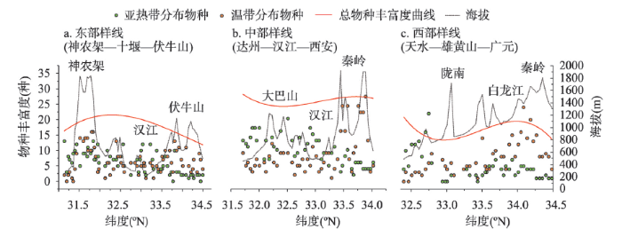
图2
秦巴山地东、中、西段物种丰富度变化
Fig. 2
Species richness variations in the eastern, middle, and western Qinling-Daba Mountains
3.1.2 相对重要值的南—北变化
相对重要值的南—北变化及多项式拟合曲线如图3所示。东部样线亚热带物种的相对重要值由北部的0~10%稳定增加至南部的40%~60%,波动不大,拟合曲线呈现稳定增加趋势。温带物种的相对重要值则在秦岭至汉江减少幅度大(由90%减少至30%~40%),汉江至神农架基本稳定在30%~40%,神农架以南开始明显减少(由40%下降至5%左右),拟合曲线呈现了由北向南先大幅降低,之后平稳保持再明显降低的趋势。亚热带与温带物种相对重要值的拟合曲线在31.80°N~33.70°N之间接近;中部样线亚热带物种的相对重要值从北向南逐步增加(由10%增加至60%左右),在大巴山地区出现高值(60%~80%),随后保持平稳,拟合曲线也呈现出由北向南升高至大巴山凸起的趋势;温带物种的相对重要值由秦岭(60%~70%)向南降低,到大巴山区减少至20%左右,拟合曲线呈由北向南先降低随后保持平稳的趋势。亚热带与温带物种相对重要值的拟合曲线在33.30 °N处相交;西部样线亚热带物种的相对重要值由北(10%)向南稳定增加至40%~60%,拟合曲线接近直线上升趋势;温带物种的相对重要值由北(90%)向南波动下降,到白龙江减少至60%左右,随后保持平稳,陇南以南开始减少至10%~20%,拟合曲线呈先减少,随后保持平稳,再大幅降低的趋势。亚热带与温带物种相对重要值的拟合曲线在32.75°N处交叉。
图3
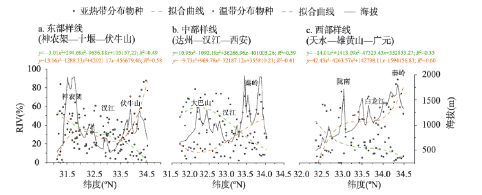
图3
秦巴山地东中西段物种相对重要值变化及拟合曲线
Fig. 3
RIV variation and curve fitting for the eastern, middle and western Qinling-Daba Mountains
3.2 秦巴山地典型物种南—北变化
秦巴山地东、中、西3条样线温带物种与亚热带物种的交错过渡区的位置及范围不同,东部样线的交错过渡带最宽,中部与西部样线的交错过渡带相对较窄(图4)。东部样线在汉江以北地区温带物种占优,亚热带物种在秦岭南坡(33.70°N)开始出现(化香树、黄檀、油桐、乌桕、朴树),亚热带与温带物种的交错带在伏牛山南坡(33.70°N)至神农架(31.80°N)之间约180 km,交错带内的主要亚热带物种包括化香树、黄檀、茅栗、山胡椒、马桑等,温带物种包括毛黄栌、油松等。交错带以南则主要为亚热带物种(马尾松、黄檀、山胡椒等)和广布种(栓皮栎、锐齿槲栎等),温带物种很少;中部样线从秦岭南坡(33.70°N)开始化香树、黄檀便已经开始出现,秦岭南坡(33.70°N)至大巴山北坡(32.80°N)之间为中部样线的交错过渡带(约100 km),其中亚热带物种包括化香树、黄檀、马尾松、油桐、棕榈等,温带物种包括刺槐、油松等;西部样线在32.75°N~33.40°N为交错过渡带(约50~60 km),该过渡带内多为温带物种(刺槐、酸枣等)和广布种(山杨、臭椿、胡桃楸等),亚热带物种较少(仅有木樨榄、楝),过渡带以南亚热带物种化香树、黄檀、青冈、马尾松、香叶树等)开始占优势。
图4
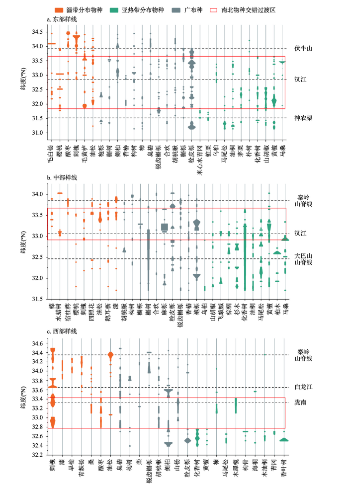
图4
典型物种沿南北方向的多度变化风筝图
注:图中的风筝图的宽度与当前物种多度成正比。
Fig. 4
Kite diagram of species abundance in north-south direction
3.3 秦巴山地物种优势程度的过渡模式及影响因素
3.3.1 SND-RIV的纬向变化模式
秦巴山地东、中、西部3条样线SND-RIV均随纬度由北向南增加,但变化模式有所不同(图5)。东部样线SND-RIV呈先增加—保持平稳—再增加的趋势,物种从秦岭北坡到伏牛山南坡(33.70°N、东秦岭南坡海拔600 m处)SND-RIV不断增大但均小于0。后由伏牛山南坡至神农架(31.80°N)SND-RIV在0左右,为亚热带与温带物种优势程度相当且变化稳定的区域。神农架及其以南SND-RIV大于0且增加趋势明显,即亚热带植物占绝对优势。中部样线由北向南温带物种的优势程度不断降低,至秦岭南坡(33.30°N左右、海拔800~1000 m)SND-RIV开始大于0,向南不断增加,在大巴山(32.80°N)最高。西部样线的SND-RIV除33.00°N周边的4个样点值较低以外,从北向南直线上升。由北向南温带物种一直保持占优的状态,陇南(32.75°N)以南,亚热带物种占优势。
图5
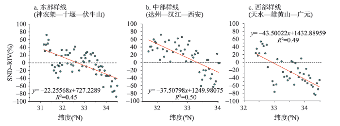
图5
秦巴山地东、中、西段SND-RIV纬向变化模式
Fig. 5
Relationship between the subtropical-temperate differences and latitude in the eastern, middle, and western Qinling-Daba Mountains
3.3.2 SND-RIV变化模式的驱动因子
秦巴山地海拔、纬度等因子与气象因子的相关关系如表2所示。东部样线的纬度与年平均降水量(-0.918**)、湿润指数(-0.756**)呈负相关,与干燥度(0.292*)呈正相关。海拔与年平均气温(-0.928**)、积温(-0.933**、 -0.915**)呈负相关,与干燥度(0.457**)呈正相关。纬度升高主要造成水分减少,海拔升高主要造成温度的减少;中部样线纬度和海拔与年平均气温(-0.620**、-0.895**)、年平均降水(-0.905**、-0.386**)、积温(-0.606**、-0.616**和-0.870**、-0.880**)均呈负相关关系,与干燥度(0.773**、0.513**)呈正相关关系,纬度与湿润指数呈负相关(-0.792**)。海拔与纬度对温度和降水均有显著影响,纬度上升对水分的减少影响更大,海拔上升对温度降低的影响更大;西部样线纬度和海拔均对温度有较大的影响,纬度与年平均气温、≥10 ℃积温、≥0 ℃积温的相关系数分别为-0.889**、-0.857**、-0.881**,海拔与年平均气温、≥10 ℃积温、≥0 ℃积温的相关系数分别为-0.896**、-0.872**、-0.891**。纬度和海拔对水分也都产生了一定的影响;3条样线总体上海拔对温度的影响更大,与年平均气温、≥10 ℃积温、≥0 ℃积温的相关系数分别为-0.896**、-0.873**、-0.855**。纬度对年平均降水量和湿润指数的影响更大(-0.705**、-0.495**)。
表2 秦巴山地地理因子与气象因子的相关关系
Tab. 2
| 地理因子 | 海拔 | 纬度 | 年平均气温 | 年平均降水量 | 湿润指数 | 干燥度 | ≥10 ℃积温 | ≥0 ℃积温 | |
|---|---|---|---|---|---|---|---|---|---|
| 纬度 | 东线 | -0.206 | 1 | 0.005 | -0.918** | -0.756** | 0.292* | 0.089 | 0.001 |
| 中线 | 0.486** | 1 | -0.620** | -0.905** | -0.792** | 0.773** | -0.606** | -0.616** | |
| 西线 | 0.841** | 1 | -0.889** | -0.571** | -0.305* | 0.313* | -0.857** | -0.881** | |
| 整体 | 0.264** | 1 | -0.356** | -0.705** | -0.495** | 0.398** | -0.337** | -0.353** | |
| 海拔 | 东线 | 1 | -0.206 | -0.928** | 0.147 | 0.186 | 0.457** | -0.933** | -0.915** |
| 中线 | 1 | 0.486** | -0.895** | -0.386** | -0.267 | 0.513** | -0.870** | -0.880** | |
| 西线 | 1 | 0.841** | -0.896** | -0.636** | -0.440** | 0.480** | -0.872** | -0.891** | |
| 整体 | 1 | 0.264** | -0.865** | -0.320** | -0.191* | 0.407** | -0.873** | -0.855** | |
注:**在0.01水平(双尾)相关性显著;*在0.05水平(双尾)相关性显著。
秦巴山地东部、中部、西部及3条样线整体的SND-RIV与气象因子的逐步线性回归模型R2均较高(表3),分别为0.687、0.702、0.729和0.746。其中东部样线年平均降水的贡献率最大为0.62,年平均气温贡献率为0.38;中部样线年平均气温贡献率最大为0.60,湿润指数贡献率为0.40;西部样线年平均降水的贡献率最大为0.64,年平均气温的贡献率为0.36。3条样线整体的线性回归模型只有≥0 ℃积温与其他气象因子存在共线性被排除,年平均气温、年平均降水、湿润指数、≥10 ℃积温、干燥度的贡献率分别为0.25、0.26、0.20、0.19、0.10。
表3 秦巴山地SND-RIV与气象因子的逐步线性回归分析
Tab. 3
| 山地位置 | 方程式 | R2 | 贡献率 | ||||
|---|---|---|---|---|---|---|---|
| 年平均气温 | 年平均降水 | 湿润指数 | ≥10 ℃积温 | 干燥度 | |||
| 东部样线 | y=4.878x1+0.191x2-223.589 | 0.687 | 0.38 | 0.62 | / | / | / |
| 中部样线 | y=8.253x1+0.696x3-106.501 | 0.702 | 0.60 | / | 0.40 | / | / |
| 西部样线 | y=4.604x1+0.169x2-188.391 | 0.729 | 0.36 | 0.64 | / | / | / |
| 整体 | y=13.845x1+0.196x2-1.438x3- 0.035x4-69.474x5-110.054 | 0.746 | 0.25 | 0.26 | 0.20 | 0.19 | 0.10 |
注:x1为年平均气温,x2为年平均降水,x3为湿润指数,x4为≥10 ℃积温,x5为干燥度。
4 讨论与结论
4.1 讨论
4.1.1 秦巴山地植物纬向变化模式及驱动因子
通过相关分析和逐步回归分析,发现秦巴山地东、中、西3条样线热量和水分的更替受到纬度、海拔不同程度的影响,从而导致植物种类和数量特征的差异。秦巴山地东、中、西海拔的升高均明显导致了热量的减少;东、中部纬度的升高导致水分的减少更明显,西线纬度的升高对热量的减少作用更大,对水分的减少也有一定的影响。低温、强风和干旱等不利的环境条件都可能限制植物生长[48]。东部植物的纬向过渡模式主要是由于纬度的升高使水分减少,从而导致由南向北亚热带植物减少,温带植物增加。神农架地区位于样线南段,水分条件较好,但海拔的升高造成了热量的减少,使得该处的温带植物占比有所升高,纬度和海拔的综合作用导致了东部南北方植物的交错过渡带较宽;中、西部由南向北纬度升高的同时,海拔也在升高,共同导致热量和水分减少,亚热带植物优势程度减少,温带植物增加,交错过渡带清晰且较窄。
4.1.2 植物南—北过渡模式与暖温带—亚热带界线划分
本文获取了秦巴山地植物纬向变化的连续数据,并将秦巴山地作为一个完整的地理和地貌单元进行研究,在东、中、西部分别得到了南北方植物的交错过渡带范围(图6),研究结果在一定程度上验证了前人的研究,并为中国南北分界线的确定提供科学依据。通过3条南北样线植物的纬向变化分析,验证了中国南北分界线并非简单的几何线条,而是具有一定宽度的过渡区域,并且该过渡区在东中西部的纬向跨度也有差异。东部交错过渡带最宽,在伏牛山南坡(33.70°N)至神农架(31.80°N)之间;中部的交错过渡带在秦岭南坡(33.70°N)至大巴山北坡(32.80°N)之间;西部的交错过渡带在32.75°N~33.40°N之间。过去依据常绿阔叶木本植物或南方物种分布的北界作为亚热带的北界的研究将分界线划在秦岭南坡或秦岭南坡海拔800~1000 m处(秦岭海拔1000 m等高线如图6所示),如张学忠等[18]、康慕谊等[16]、张兴航等[28]。在赵芳等[22]的研究中,山地垂直带谱的基带所表现的北亚热带—暖温带的过渡带在秦巴山地东部为伏牛山南坡至神农架北坡,中部为太白山南坡至米仓山北坡,西部为白水江自然保护区以南。寇志翔等使用多个气候指标,并参考植被、土壤数据探讨了亚热带北界界限的位置[49]。本文植物交错过渡带的北界与前人提出的北亚热带的北界位置相差不大,并且本文进一步给出了植物交错过渡带的范围,为中国暖温带与亚热带界线的划分及综合地理区划提供了数据支撑。
图6
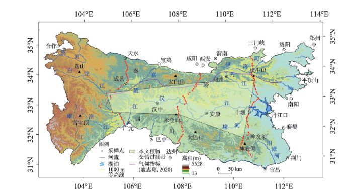
图6
秦巴山地植物交错过渡区及中国亚热带北界划分方案
Fig. 6
Plants crisscross area of the Qinling-Daba Mountains and demarcation of the northern boundary of the subtropical zone in China
中国暖温带与亚热带的具体地理分界线的位置一直存在争议,其原因除了各学科使用的指标不同之外,同样受到了研究尺度、判别标准的差异的影响,关键的问题在于对南北平均宽度300 km的秦巴山地内部气候和植被分异缺乏详细的了解。本文采用了3条南北样线的植被序列调查数据,仍需进一步增设样线数量,或在秦岭、大巴山进行更加深入的植物群落调查,从而更加全面的展示秦巴山地植物的组成和南北变化模式,降低山地小气候及人为因素对过渡带划定的影响,研究结果将更加全面和科学。秦巴山地范围内自然保护区约40个,覆盖范围较为全面,自然保护区内的植物名录能够为植物分布的研究提供数据支撑,植物区系的研究同样能够为南北过渡带位置的划定提供依据。中国暖温带与亚热带的分界线是一个综合地理分界线,仅仅依靠植物的分布是不能够得到最终结论的,气温、降水等气候指标的空间变化模式、土壤的空间分布与变异模式同样是中国南北分界线划分的重要依据。本文仅使用了已有的气象背景数据进行了相关分析和回归分析,未来研究仍然需要最新且更加精确的气候空间分布数据,将植物分布与气候、土壤结合,给出更加科学、准确的南北过渡带位置,并进一步探讨气候变化对中国南北过渡带位置的影响。
4.2 结论
本文基于秦巴山地东、中、西部3条南北穿越样线163个样点的植被实地调查数据分析,总结了秦巴山地由南向北物种类型与重要值的变化,结论如下:
(1)亚热带与温带物种的交错过渡区在秦巴山地东、中、西部有较大差异:东部(伏牛山—神农架)最宽,约180 km;中部(西安—达州)样线的交错过渡带位于样线中部约100 km;西部样线的交错过渡带偏南,约50~60 km。
(2)秦巴山地东部(伏牛山—神农架)自南向北亚热带物种的减少主要与年均降水量减少有关;中部(西安—达州)与水热均相关,但年平均气温的作用比湿润指数稍大;西部(广元—天水)温带与亚热带物种的南北变化,主要与年平均降水量相关。
参考文献
Ten major scientific issues concerning the study of China's north- south transitional zone
DOI:10.18306/dlkxjz.2019.03.001
[本文引用: 4]

Since the Qinling-Huaihe line was delimited as the boundary between north and south China in 1958, discussions on the local position of the line, criteria for dividing temperature zones, the line's environmental effect, among others, are ongoing. The National Basic Resources Investigation Program "Integrated Scientific Investigation of the North-South Transitional Zone" launched in 2017, introduced the concept of north-south transitional zone (Qinling-Daba Mountains) and planned to explore the north-south dividing line from the perspective of transitional zone, so as to strengthen and make some breakthroughs in the study of the north-south division. The Qinling-Daba Mountains are the main body of China's north-south transitional zone, with multi-dimensional zonal structures and high degree of environmental complexity, biological diversity, and climatic sensitivity. The following 10 scientific issues need to be dealt with in the years to come: 1) The relationship between the north-south dividing line and the north-south transitional zone; 2) improvement of criteria for identifying subtropical and warm-temperate zones; 3) integral north-south series and variation of vegetation and soil types; 4) relationship between global warming and spatial change of key bioclimatic criteria; 5) decomposition and integration of multi-dimensional zonal structures in the Qinling-Daba Mountains; 6) pattern and mechanism of biological diversity and endemics; 7) the corridor effect of the Qinling-Daba Mountains; 8) regional environmental effect of the Qinling-Daba Mountains and implications for the national ecological security; 9) significance and position of the Qinling-Daba Mountains for the history and development of China; and 10) significance of the geographic structure of Western Qinling Mountains for the origin of the Chinese civilization. These key issues are not only the results of previous research, but also the starting point for further exploration and study in the future. They are intended to inspire and encourage an in-depth study of China's north-south dividing line or transitional zone, and to provide new perspectives and framework for the exploration of physio-geographic theories, biodiversity, and ecological security, and even the birthplace of the earliest Chinese civilization.
中国南北过渡带研究的十大科学问题
DOI:10.18306/dlkxjz.2019.03.001
[本文引用: 4]
秦岭-淮河一线在60 a前被科学地确定为中国南北分界线。此后中国地学科学家一直在探索分界线的具体位置和划分指标改进问题;随着数据的积累和认识的加深,还发现了一些新的科学问题。2017年启动的国家科技基础资源调查专项“中国南北过渡带综合科学考察”将秦岭-大巴山定义为中国南北过渡带的主体,拟全面系统地调查和研究其自然地理要素与资源问题,从而实现中国南北分界线研究的全面深化和突破。秦岭-大巴山具有多维地带性结构,表现出高度的过渡性、复杂性、多样性和敏感性。目前面临和需要研究的主要科学问题包括:① 南北分界线与南北过渡带的关系?② 暖温带与亚热带划分指标如何改进?③ 植被-土壤在南北方向上的渐变序列及其形成机理?④ 全球变化与地区关键生物气候指标空间变动的关系?⑤ 秦巴山地的多维地带性结构如何分解与综合?⑥ 秦巴山区生物多样性、特有性的格局与机理?⑦ 秦巴山地东西向廊道效应?⑧ 秦巴山地的区域环境效应及对国家生态安全的意义?⑨ 秦巴山地在中国历史发展中的特殊意义?⑩ 西秦岭的地理结构与华夏文明起源的关系?这些问题既是过去研究工作和认识的总结,也是未来一段时间内需要关注和研究的重点。希望这样的归纳和梳理对于中国南北过渡带和南北分界线的科学研究具有一定的启发和促进作用,为中国自然地理学理论发展、生物多样性和生态安全研究,甚至为华夏文明起源的研究提供新的视角和框架。
Subtropics of China
中国的亚热带
Vegetation-climate relationship and its application in the division of vegetation zone in China
植被气候关系与我国的植被分区
Eco-climatic analysis of forest zones in China
我国森林植被带的生态气候学分析
Re-discussion about the forest vegetation zonation in eastern China
也论我国东部植被带的划分
The preliminary study of the correlations between the distribution of main everygreen broad-leaf tree species in Jiangsu and climats
江苏主要常绿阔叶树种的分布与热量关系的初步研究
A discussion on the controversial issues in scheme for vegetation regionalization of China
试论历次中国植被分区方案中所存在的争论性问题
Discussion on the principle, basis and the system unit for vegetation regionalization of China
论中国植被分区的原则、依据和系统单位
Draft of the complex physical geographical division of China
中国综合自然区划草案
Geobotanical zone of Henan Province, discussion on the division between north subtropical zone and south warm temperate zone
河南地植物带, 北亚热带向南暖温带过渡界线的探讨
The vertical zonation of mountain vegetation in China
DOI:10.11821/xb198103003
[本文引用: 1]
On account of vast territory and complex physico-geographical conditions as well aagreat human impacts, the distribution of mountain vegetation in China is very compli-cated. Yet, law of zonation still holds true. The structure and character of mountainvegetation change along two directions, i.e., from south to north and from east to west.In the eastern part of China altitudinal vegetation-belt spectrums change mainlyfrom south to north.1. Warmth-like types of altitudinal vegetation-belt spectrums being replaced bycold-resistant types with alternation of basic vertical vegetational belts from evergreenbroad-leaved forests to deciduous needle-leaved forests.2. Diminution of number of altitudinal belts and simplification of their structures.3. Lowering down of altitudes of altitudinal vegetational belts. On mountains inwestern part of subtropical zone lies the highest altitude of timberline in the world, witha maximum altitude of over 4,400 m above the sea level. It lowers down towards northby over 100 m per degree of latitude.4. Occurrence of dominant belts in vertical profiles of mountain vegetation de-pends upon the nature of horizontal zones. The dominant belts in typical geographicalzones are certainly the basic vertical vegetational belts. And in transitional zones theyoccur above the basic vertical belts.While in the arid and semi-arid western part of China, changes of altitudinal vege-tation-belt spectrums are quite different. They take place chiefly from east to west. Itis worthwhile mentioning that structures of vegetation-belt spectrums are very simpli-fied, steppes and deserts occupy the dominant position on mountains and all altitudinalvegetational belts ascend in this direction.
我国山地植被的垂直分布规律
DOI:10.11821/xb198103003
[本文引用: 1]
地球上植被的大型分布,明显地呈现地带性变化。平地上表现为水平地带性,包括纬度地带性和干燥度地带性;山地上表现为垂直(地)带性,就是所谓“三维空间”分布现象。我国地广山多,自然条件复杂,研究山地植被的分布规律不但具有理论意义,而且也富有实践意义。
The vegetation types of China
DOI:10.11821/xb195601002
[本文引用: 1]
China has a very vast area, complex environment and rich plant species comprising arctic, temperato and tropical types. In addition to climatic, edaphic and topographical differences in different geographical regione, the vegetation-ty-pes havo been made more complicated by certain geological factors, the glacial factor, for instance, which resulted in remaining certain amount of preglacial remnants in certain places. The anthrohic effects for more than 5,000 years have certainly caused profound changes in our natural vegetation. In general, the en- vironmental factors which affect the vegetation most are climatic, topographic, edaphic, histbric and biotic onus among which the climate is certainly the most important, but in connection wiili other features its effect is expressed differently in different regions. In China, in western part, especially in Tibetan plateau, the topographical factor becomes most prominent; in northern and eastern parts the cold tide predominates,in the coastal region the Pacific and Indian monsoons play the leading part.
中国植被的类型
DOI:10.11821/xb195601002
[本文引用: 1]
我国地域广大,环境复杂,植物种类在25,000种以上,兼有寒带、温带、热带三种类型。各地区的气候、土壤、地形的差异很大,而气候、土壤、地形的不同组合和相互影响,又都根本地影响着各地区的植被群落。
Discussion and analysis on the geo-ecological boundary in Qinling range
秦岭山地生态分界线的论证
The transitional characteristics of vegetation and the boundary between north and south in Huaihe River Basin
淮河流域植被的过渡性特点及南北分界线的探讨
A preliminary discussion on the northern boundary of subtropical zone in China: Based on the distribution of broadleaf woody evergreens on the Qinling Mountain
DOI:10.11821/xb197904006
[本文引用: 2]
This paper states the distribution of 177 species (including their varieties) of broadleaf woody evergreens on the Qin-lin Mountain, based on the viewpoint of specific phytogeographic or floral elements. It is possible to classify these species into two groups: One may be considered as that belongs to typical subtropical floral elements which are located on the southern slope of Qin-lin Mountain (Table 3); the other may be belong to the temperate ones which are found on the northern slope of the Qin-lin Mountain (Table 4). According to the distribution of above-mentioned floral elements, the northern boundary of the subtropical zone of China is located near 1000 m. above sea level on the southern slope of central part of Qin-lin Mountain, lying approximately from Latitude 33°5’, Wudu of Gansu Province, to 33°5’ North, the southern slope of the Funiu Mountain of Henan Province.
从秦岭南北坡常绿阔叶木本植物的分布谈划分亚热带的北界线问题
DOI:10.11821/xb197904006
[本文引用: 2]
关于划分我国亚热带的北界问题,意见虽不一致,但主张以秦岭淮河一线为界者较多,然而秦岭南北宽约300公里,此线应划何处较为合适,至今意见仍有分歧。
Vegetation regionalization in Qinling Mountains (draft)
秦岭地区的植被区划(草案)
Division between subtropical zone and temperate zone in Henan Province according to geo-botany
DOI:10.11821/xb198102010
[本文引用: 1]
一、前言 亚热带与暖温带的分界线,在我国是一条重要的自然界线,它的划分问题,引起了自然地理学、气候学、土壤学和地植物学等科学工作者的争论。研究这个问题不仅在理论上具有重要意义,而且它是综合自然、农业、林业等区划的依据之一。所以,亚热带与暖温带分界线的划分,能否正确地反映自然界的客观规律,是关系到运用这规律来指导生产实践的大问题。
从地植物学角度试论河南省境内亚热带与暖温带的分界线问题
DOI:10.11821/xb198102010
[本文引用: 1]
一、前言 亚热带与暖温带的分界线,在我国是一条重要的自然界线,它的划分问题,引起了自然地理学、气候学、土壤学和地植物学等科学工作者的争论。研究这个问题不仅在理论上具有重要意义,而且它是综合自然、农业、林业等区划的依据之一。所以,亚热带与暖温带分界线的划分,能否正确地反映自然界的客观规律,是关系到运用这规律来指导生产实践的大问题。
Division of the geo-ecological boundary in Qinling Mountain Range based on the composition and geographical elements of its Pteridophyta flora
DOI:10.11821/yj2010090009
[本文引用: 1]
The Qinling Mountain Range is considered as an important geo-ecological boundary between the warm temperate and the subtropical zones in eastern China, however, the specific line of the boundary has been controversial among the academic circles. Several studies based on vegetation ecology and flora geography have been done on discussing the division of this boundary, but in all of which Pteridophyta is not included. Pteridophyta is a transitional link between different flora groups in plant evolution, and thus is more sensitive to the environment that fosters it than other plant groups. It is conducive to and necessary for a better understanding of the division of the geo-ecological boundary in Qinling Mountain Range to research into the Range's Pteridophyta flora. In this paper, the composition and geographical elements of the flora of Pteridophyta were studied, and the division of the vertical Pteridophyta spectrum and the further division of the geo-ecological boundary in Qinling Mountain Range were also discussed, by applying the principles of classical florology and using quantitative ecology method as TWINSPAN and DCA into the analyses, based on comparison between the field investigation data and the relevant literatures. The results of our research have shown and revealed: 1) There are 311 species of Pteridophyta, belonging to 85 genera and 36 families in the Qinling Mountain Range; in which the dominant families are Dryopteridaceae, Athyriaceae, and Polypodiaceae, and the dominant genera Dryopteris and Polystichum; meanwhile, the main areal-types of family and genera are tropical elements, while the areal-types of species is dominated by the temperate elements. 2) The altitude of 1000 m a.s.l. at the southern piedmont of the Range should be an important ecological boundary, since the floristic composition of the Pteridophyta below this elevation showed more similar features to the subtropics, while above it the features of the composition and the vertical vegetation spectrum of the Pteridophyta are much closer to the temperate zones. 3) DCA ordination of FER (floristic element ratio) among 15 regions in northern and southern China and the both sides of Qinling Mountain Range strongly supported the hypothesis mentioned above. Based on these results, we tend to deem that the geo-ecological boundary between the subtropical and warm temperate zones lies around the altitude of 1000 m a.s.l. at the southern piedmont of the Range.
从秦岭蕨类植物区系地理成分论秦岭山地生态分界线的划分
DOI:10.11821/yj2010090009
[本文引用: 1]
依据2007~2008年野外实地调查以及相关文献资料,运用植物区系地理学和数量生态学方法,分析了秦岭蕨类植物区系的物种组成和地理分布特征,划分了秦岭蕨类植物的垂直带谱,并以此为基础探讨了秦岭山地生态分界线的划分,得出以下主要结论:(1)秦岭共有蕨类植物36科85属311种,优势科为鳞毛蕨科、蹄盖蕨科和水龙骨科,优势属为鳞毛蕨属和耳蕨属;在科属水平上,以热带成分占优势;而种的水平则以温带成分占绝对优势。(2)根据秦岭蕨类植物南北坡垂直带谱的对比分析,南坡海拔1000m左右应该是一条重要的生态分界线。(3)南坡1000m以下蕨类植物区系组成更接近亚热带区系,而其他地带则与温带蕨类植物区系更为接近,DCA排序很好地证明了此结果。综合来看,将南坡海拔1000m作为秦岭山地亚热带与暖温带的生态分界线较为科学。
Spatial variation of altitudinal belts as dividing index between warm temperate and subtropical zones in the Qinling-Daba Mountains
DOI:10.1007/s11442-020-1747-2
[本文引用: 2]
To determine the dividing index between warm temperate and subtropical zones based on the spectra of altitudinal belts, this paper collected 33 spectra of altitudinal belts in the Qinling-Daba Mountains from published literatures and then analyzed the structures and the spatial patterns from south to north, from west to east and based on exposure directions. The results show that: 1) From south to north, the basal belt gradually changes from subtropical evergreen broadleaf forest to warm temperate deciduous broadleaf forest; the spectra of altitudinal belts change from complex to simple; the dominant belt changes from montane broadleaf-conifer mixed forest and evergreen-deciduous broadleaf mixed forest to deciduous broadleaf forest. 2) From west to east, the structures of the altitudinal belt spectra show complexity in the east and west but simplicity in the middle section; the upper limits of both the evergreen-deciduous broadleaf mixed forest belt and montane deciduous broadleaf forest belt present a quadratic curve distribution pattern in the longitudinal direction. However, the upper limit of the montane broadleaf-conifer mixed forest belt exhibits a nearly linear decrease in the west-east direction. 3) Both the north and south slopes in the Qinling Mountains have the similar basal belt, whereas it varies greatly between the north and south slopes in the Daba Mountains. Comparably, dominant belts are very similar in the Qinling Mountains and the north slope of the Daba Mountains, but the south slope of the Daba Mountains has its own unique dominant belt: evergreen-deciduous broadleaf mixed forest. This implies that the Daba Mountains are more appropriate than the Qinling Mountains to act as the boundary between subtropical and warm-temperate zones in central China.
Perspective of the vegetation zonation of forest region in eastern China
中国东部森林植被带划分之我见
Observations on the flora and vegetation of Taibaishan, Qinling Mountain range, southern Shaanxi, China
秦岭太白山地区的植物区系和植被
Summary of soviet experts' opinions on "Draft Comprehensive Physical Regionalization of China"
苏联专家对“中国综合自然区划草案”的意见摘要
Altitudinal patterns of plant species diversity in Mt. Niubeiliang, Qinling Mountains
DOI:10.17520/biods.2004013
[本文引用: 1]
Using quantitative analysis (DCA and TWINSPAN), the vegetation and plant species diversity patterns along the elevation gradient in Mt. Niubeiliang, Qinling Mountains were studied based on 51 plots along two altitudinal transects between 1500 m and 2800 m on northern and southern slopes. Plant communities varied continuously along the elevation gradient. From low to high elevation, mountain oak forest, mountain birch forest, subalpine fir forests and subalpine shrub occurred on both slopes. Relationship between communities and topographic variables were analyzed by detrended correspondence analysis (DCA). Elevation was the primary determinant of floristic composition in Mt. Niubeiliang, and followed by exposure. In terms of species diversity, different patterns existed among total number of species, woody species richness and herbaceous species richness, and also between southern and northern slopes. The total number of species changed unimodally with elevation on the southern slope, peaking at middle elevations. No significant relationship between total number of species and elevation was detected on the northern slope. Woody species richness changed similarly on both southern and northern slopes, keeping stable at low elevations and decreasing monotonically with the increasing elevation at high elevations. In contrast, no significant pattern of herbaceous plant richness existed along the elevation gradient. β diversity was higher at lower and higher elevations than in the mid-altitudinal zone, indicating a more homogeneous habitat at middle elevation than upper and lower elevations. Human disturbance at lower elevation and the timberline ecotone at higher elevations may contribute to the increase of β diversity in these areas.
秦岭牛背梁植物物种多样性垂直分布格局
DOI:10.17520/biods.2004013
[本文引用: 1]
基于秦岭山脉中段牛背梁自然保护区南北坡垂直样带51个样方的调查资料,利用植被数量分析方法(TWINSPAN和DCA)对牛背梁植物群落进行了分类和排序,并分析了植物物种多样性沿海拔梯度的分布格局。结果表明,牛背梁的植被群落具有明显的海拔梯度格局,从低海拔到高海拔依次分布有: 锐齿槲栎(Quercus aliena var. acuteserrata)林,桦木(Betula spp.)林,巴山冷杉(Abies fargesii)林和亚高山灌丛。海拔梯度是牛背梁山区制约植物群落分布的主要因子,而坡向和坡度则起到次要作用。对物种多样性的分析表明,物种总数、木本植物物种多样性和草本植物物种多样性在南北坡具有不同的海拔梯度格局。物种总数在南坡呈现单峰分布格局,而在北坡分布趋势不明显; 木本植物物种多样性在南北坡具有相似的分布格局: 在低海拔沿海拔梯度变化不明显,而在高海拔则随海拔上升而急剧下降; 草本植物物种多样性在南北坡沿海拔梯度变化的规律不明显。β多样性沿海拔梯度先减少后增加,形成两端高中间低的格局,说明中海拔地区生境条件较为均一,低海拔地区的人为活动增加了生境的异质性,而高海拔地区的生态过渡特性增加了物种的更替速率以及群落的相异性。
North-south transect series in vegetation of eastern China's north-south transitional zone and their significance for determining climate dividing line
DOI:10.11821/dlxb202101003
[本文引用: 2]
The National Basic Resources Investigation Program "Integrated Scientific Investigation of the North-South Transitional Zone" introduced the concept of north-south transitional zone (Qinling-Daba Mountains). Variation of north-south series in vegetation of the Qinling-Daba Mountains is of great significance to reveal the transition, diversity and complexity of the regional structure of China's north-south transitional zone. Based on the survey data of plant communities, in this study, the eastern Qinling-Daba Mountains is divided into four geography units: north flank of eastern Qinling Mountains (EQMN), south flank of eastern Qinling Mountains (EQMS), north flank of eastern Daba Mountains (EBMN), south flank of eastern Daba Mountains (EBMS). The regional climate divisions on levels of plant species, plant community structure and species richness are explored. The results show that: (1) On plant species level, there are mainly north plants in EQMN, evergreen species and fewer north plants in EQMS. Then to the eastern Daba Mountains, there are mainly south plants which like wetness and heat. (2) On plant community structure level, there are 4 formations (3 northern formations, 0 southern formation, 1 widespread formation) in EQMN, 6 formations (3 northern formations, 1 southern formation, 2 widespread formations) in EQMS, 4 formations (0 northern formation, 2 southern formations, 2 widespread formations) in EBMN, 3 formations (0 northern formation, 3 southern formations, 0 widespread formation) in EBMS. In terms of the numbers and properties of formation, there is a mixture of northern and southern formations only in EQMS. On species richness level, the diversity of family, genus and species decreases with the increase of latitude, but the mixture of north and south plants occurred in the south flank of eastern Qinling Mountains. This paper studies the variation of series in vegetation, which increases the scientificity of determining north-south dividing line, and shows that the south flank of eastern Qinling Mountains is more suitable as the warm temperate-subtropical zones dividing line.
中国南北过渡带东段样带植被序列与气候分界问题
DOI:10.11821/dlxb202101003
[本文引用: 2]
国家科技基础资源调查专项“中国南北过渡带综合科学考察”将秦岭—大巴山定义为中国南北过渡带的主体,秦巴山地植被南北变化研究,对于揭示中国南北过渡带地域结构的过渡性、多样性和复杂性具有重要意义。基于植物群落实地调查数据,本文将中国南北过渡带东段分为:东秦岭北麓(EQMN)、东秦岭南麓(EQMS)、东大巴山北麓(EBMN)和东大巴山南麓(EBMS)4个地理单元,从植物物种、群落结构和物种多样性三个层面,对区域气候分界问题进行研究。结果表明:① 植物种类层面,EQMN主要为北方植物,EQMS出现常绿树种且北方植物减少,东大巴山以喜湿喜热的南方植物为主。② 群落结构层面,EQMN群系有4个(北方群系3个,南方群系0个,广布群系1个)、EQMS有6个(北方群系3个,南方群系1个,广布群系2个)、EBMN群系有4个(北方群系0个,南方群系2个,广布群系2个)、EBMS群系3个(北方群系0个,南方群系3个,广布群系0个),只有EQMS群系出现南北性质混合;③ 丰富度层面,随着纬度增加,科、属、种3个分类群物种多样性均减小,但南北方植物混合现象开始在EQMS出现。本文对植被变化序列的研究增加了对东秦巴山地南北分界线判断的科学性,东秦岭南麓更适合作为暖温带—北亚热带的分界线。
Numerical classification, ordination and species diversity along elevation gradients of the forest community in Xiaoqinling
小秦岭森林群落数量分类、排序及多样性垂直格局
Spatial distribution patterns of Pinus tabulaeformis forest and Pinus massoniana forest in Qinling-Daba Mountains and the boundary of subtropical and warm temperate zones
DOI:10.11821/dlxb202011002
[本文引用: 1]
Qinling Mountains is not only the geographical boundary between North and South China, but also the boundary between subtropical and warm temperate zones. It plays an important role in the geo-ecological pattern of China. However, there is controversy about the specific location of this geographical boundary in academic community due to the complexity, transition and heterogeneity of the transitional zone, as well as the differences in the delimitation indicators and research purposes. To further reveal the characteristics of the North-South transitional zone and clarify the specific location of the geo-ecological boundary between North and South China, combined with SRTM topographic data, temperature and precipitation data, Pinus massoniana forest and Pinus tabulaeformis forest, which represent subtropical coniferous forests in South China and temperate coniferous forest in North China respectively, were chosen to analyze their spatial distributions in the Qinling-Daba Mountains and the climatic conditions at their boundary with the climatic indexes of annual precipitation, the coldest month (January) average temperature, the warmest month (July) average temperature and the annual average temperatures. The results show that: (1) Pinus massoniana and Pinus tabulaeformis forests and the climate indicators of their boundary can be used as one of the vegetation-climate indicators for the delimitation of subtropical and warm temperate zones. The boundary between the subtropical coniferous forest (Pinus massoniana forest) and temperate coniferous forest (Pinus tabulaeformis forest) in Qinling-Daba Mountains is located along the south slope of Funiu Mountain to the north edge of Hanzhong Basin (the south slope of Qinling Mountains) at an altitude of 1000-1200 m, where the climatic indictors are stable: the annual precipitation is about 750-1000 mm; the annual average temperature is about 12-14 ℃; the coldest monthly average temperature is 0-4 ℃; and the warmest monthly average temperature is about 22-26 ℃. (2) It could be more scientifically to delimitate the boundary of subtropical and warm temperate zones in China by comprehensively considering the vegetation-climate indicators. Additionally, the boundary between subtropical and warm temperate zones in Qinling-Daba Mountains should be a transitional zone consisting of the boundaries of coniferous forests, broad-leaved forests and shrubs between subtropical and warm temperate zones. The results provide a scientific basis for the selection of delimitation indicators of subtropical and warm temperate zones.
秦巴山区马尾松林和油松林的空间分布及亚热带与暖温带界线划分
DOI:10.11821/dlxb202011002
[本文引用: 1]
秦岭不仅是中国南北的地理分界线,也是中国亚热带和暖温带的气候分界线,在中国地理生态格局中占有重要的地位和作用。由于过渡带的复杂性、过渡性和异质性以及划分指标、研究目的的不同,学术界关于这一南北地理—生态分界线的具体位置一直有争论。为了进一步揭示秦巴山区过渡带的特征,明确中国南北地理—生态分界线的位置,本文选择马尾松(Pinus massoniana)林和油松(Pinus tabulaeformis)林这两类分别代表中国南方亚热带针叶林和北方温带针叶林的植被,结合研究区SRTM地形数据、气温和降水数据等,以年降水、最冷月(1月)气温、最热月(7月)气温和年均温为气候指标,详细分析了这两类植被在秦巴山区的空间分布及二者分界线处的气候条件。结果表明:① 马尾松林和油松林的分界线及相应位置的气候指标可以作为亚热带与暖温带界线划分的植被—气候指标之一。秦巴山区亚热带针叶林(马尾松林)与温带针叶林(油松林)的分界线位于伏牛山南坡至汉中盆地北缘一线(秦岭南坡)海拔1000~1200 m处;分界线处气候指标稳定:年降水750~1000 mm,年均温12~14 ℃,最冷月气温0~4 ℃,最热月气温22~26 ℃。② 通过综合的植被—气候指标来划分秦巴山区亚热带和暖温带的界线,能更科学地确定气候带分界线的位置及过渡带的特征,更全面地反映地表植被—气候格局的变化。此外,秦巴山区亚热带与暖温带的界线应该是由亚热带与暖温带针叶林分界线、阔叶林分界线、灌丛分界线等组成的一个过渡带。本文的研究结果为亚热带与暖温带划分指标的选取提供了一定的科学依据。
A study on the spermatophyta flora in the Jigongshan natural sanctuary in south Henan
豫南鸡公山自然保护区种子植物区系的研究
Preliminary investigation on the vegetation of Dabashan nature reserve and its characteristics
大巴山自然保护区植被及其特征的初步研究
Community characteristics of a deciduous broad-leaved forest in a temperate-subtropical ecological transition zone: Analyses of a 5-hm2 forest dynamics plot in Baiyunshan Nature Reserve, Henan Province
暖温带—北亚热带过渡区落叶阔叶林群落特征
Population dynamics of dominant species in the forest ecosystem at Funiu Mountain National Nature Reserve
伏牛山自然保护区森林生态系统乔木层优势种种群动态
The plant communities' vertical distribution and the species' diversity in Funiu mountain nature reserve
伏牛山自然保护区植物群落垂直分布与物种多样性分析
Methods and protocols for plant community inventory
DOI:10.3724/SP.J.1003.2009.09253
[本文引用: 1]
A plant community is an assemblage of plant populations that live in certain area, and interact with and adapt to one another in the context of long-term environmental changes. Plant communities maintain global ecosystem functions, and provide food and habitats for animals and other organisms. Plant communities also provide primary resources for human survival and development, and are therefore indispensable to human societies. China is among the countries with the most diverse plant communities in the world. However, no systematic national inventory has been conducted for Chinese plant communities. This fact obstructs exploitation and protection of China’s plant resources, and also hampers the development of the fields of Chinese ecology and geography. There is an urgent need to survey Chinese plant communities using consis-tent methods and protocols. In this paper, we review major concepts in plant community ecology, and pro-pose a framework for developing plant community inventories based on recent progress in community ecol-ogy and our own experience with long-term field surveys. Our framework provides protocols for site selec-tion and plot design, items to be measured in a plot, and measurements of functional traits of dominant spe-cies. We also review protocols for field surveys of large, long-term plots. The protocols proposed in this pa-per are expected to be a base for standardizing methodology for inventory of Chinese plant communities.
植物群落清查的主要内容、方法和技术规范
China meteorological background dataset
中国气象背景数据集
An ecological significance of evergreenness
DOI:10.2307/1932995 URL [本文引用: 1]
Transition patterns across an evergreen-deciduous broad‐leaved forest ecotone: The effect of topographies
DOI:10.1111/jvs.12156 URL [本文引用: 1]
A comparison of classifications of families of Chinese vascular plants among Flora Republicae Popularis Sinicae, Flora of China and the new classifications
DOI:10.3724/SP.J.1143.2012.12012 URL [本文引用: 1]
中国植物志、Flora of China和维管植物新系统中科的比较
The areal-types of Chinese genera of seed plants
中国种子植物属的分布区类型
Some problems in references on floristic studies in China
中国植物区系研究文献中存在的几个问题
Notes on the history of correlation
DOI:10.1093/biomet/13.1.25 URL [本文引用: 1]
Stepwise regression analysis and its application
逐步回归分析法及其应用
The upper timberlines in different climatic zones
Delimitation of the northern boundary of the subtropical zone in China by geodetector
DOI:10.11821/dlyj020191026
[本文引用: 1]
The boundary between warm temperate and subtropical zones is an important natural boundary in physical regionalization; however there is controversy about the specific location of the boundary. Because the earlier physical regionalization was mainly based on qualitative methods with expert knowledge, and the regionalization objectives and the adopted indicators were different, scholars had differences in the divisions of physical regions. Based on the idea of spatial differentiation, this paper used geodetector to quantitatively examine the impact of climate indicators on the northern boundary of subtropical zone of China, selected the important indicators with a large q value as the dominant factor and refered to the vegetation and soil data to explore the location of the subtropical northern boundary. The results show that: (1) The geodetector method can quickly and accurately screen the main climate indicators of physical regionalization, decide the precise location of the boundary, which improves the technical level of physical regionalization research and the objectivity of physical regionalization. (2) The new boundary delimitated in this paper is located at the altitude of 1000-1600 m on the south slope of the Qinling Mountains in the western part of the study area, slightly south compared to the previous boundaries (it is consistent with that of Zheng Du and Xi Chengfan in the east of Shaanxi); and it is north compared to the previous boundaries (especially in the north of eastern Henan and northern Anhui) in the eastern part of the study area. While maintaining the integrity of natural elements, the new boundary has a larger q value, indicating that it can well reflect the difference between the warm temperate zone and the northern subtropical zone, and the division results are reasonable.
基于地理探测器的中国亚热带北界探讨
DOI:10.11821/dlyj020191026
[本文引用: 1]
暖温带与亚热带的分界线,是自然区划中一条重要的自然界线,它的划分问题曾引起诸多学科学者的争论。由于早期综合自然区划研究多以定性、专家集成方法为主,同时区划目的、使用指标等多有不同,导致不同学者所划分的自然区多存在一定的差异。本文基于空间分异性思想,使用地理探测器定量探测气候指标对中国亚热带北界的影响,选择其中q值较大的指标如日均温≥0℃天数、最冷月1月均温、年降水和湿润指数等作为主导因子并参考植被、土壤数据探讨亚热带北界界线的位置。结果表明:① 地理探测器法可以快速、准确地筛选自然区划的主要气候指标,并确定分界线的准确位置,提高了自然区划研究的技术水平和区划界线的客观性。② 使用地理探测器划分的新界线在研究区西部位于秦岭南坡1000~1600 m的位置,与以往界线相比略偏南;在研究区东部河南东部、安徽北部比以往界线略偏北。在保持自然要素完整性的同时,新界线具有更大的q值,表明新界线可以很好的反映暖温带与北亚热带2个区划带之间的差异,划分结果具有合理性。
