南京大学地理与海洋科学学院,南京 210023
收稿日期: 2015-06-12
修回日期: 2015-07-19
网络出版日期: 2015-09-20
版权声明: 2015 《地理学报》编辑部 本文是开放获取期刊文献,在以下情况下可以自由使用:学术研究、学术交流、科研教学等,但不允许用于商业目的.
基金资助:
作者简介:
作者简介:张威(1993-), 男, 主要研究方向为地球化学和气候变化。E-mail: tianxinzw@outlook.com
展开
摘要
土壤侵蚀是关系人类生存与可持续发展的重大环境问题。20世纪60年代以来,Cs-137作为一种人工放射性示踪核素,被广泛应用于土壤侵蚀及堆积研究。而准确估算区域Cs-137背景值(Cs-137 Reference Inventory, CRI)是应用Cs-137开展土壤侵蚀研究的前提条件,其结果直接影响土壤侵蚀速率结果的准确性和可靠性。基于现有文献资料中获取的中国大陆102个CRI实测数据,以及全球降水气候中心提供的降水量再分析资料(空间分辨率2.5°×2.5°、0.5°×0.5°,1981-2010年),在借鉴Walling & He模型(Walling & He Model, WHM)和Michio Aoyama模型(Michio Aoyama Model, MAM)的基础上,本文建立了中国大陆CRI修正模型(Modified CRI Model for the Mainland of China, MCM),并利用Kriging/Cokriging插值方法计算了中国大陆CRI的空间分布。模型评估与对比分析表明,MCM模拟值与实测值大致吻合,且总体高于WHM和MAM模拟值,MCM能对中国大陆CRI进行较高分辨率、较高精度的模拟。模拟结果显示,中国大陆CRI的范围为141~12123 Bq/m2,在东北及新疆局部地区达到最大值,最小值主要集中于25°N以南地带。除新疆局部地区外,中国大陆CRI分布整体呈现自西向东,同纬度地区随降水量增加而增加的特点,而纬向上主要呈现随纬度增加而增加的特点。此外,大尺度大气流场、再悬浮过程、局部核试验等因素增加了中国大陆CRI分布的不均匀性。
关键词:
Abstract
Soil erosion is a serious environmental problem closely associated with sustainable development and ultimately the survival of mankind. Cesium-137, a unique artificial radioactive tracer, has been widely applied to the study of soil erosion and deposition since the 1960s. Furthermore, it is a basis for determining a Cesium-137 Reference Inventory (CRI) that employs cesium-137 to measure soil erosion, which can directly influence the accuracy and reliability of the soil erosion rate. This paper references 102 CRI data samples collected from over 80 documents; it also uses the monthly precipitation dataset from the Global Precipitation Climatology Centre from 1981-2010, with spatial resolutions of 2.5°×2.5° and 0.5°×0.5°. The Modified CRI Model for the Mainland of China (MCM) that the paper established is based on incorporating and modifying two previous models, the Walling & He Model (WHM) and the Michio Aoyama Model (MAM). Then we calculate the geographical distributions of CRI by using Kriging/Cokriging interpolation. The model assessment and comparative analysis demonstrate that MCM simulated values are generally in agreement with the observed values and greater than WHM and MAM simulated values. MCM can be applied to higher resolution and higher precision CRI modeling in the Mainland of China. The results show that the range of CRI in the Mainland of China is between 141 and 12123 Bq/m2, and the maximum values are found in parts of northeast China and Xinjiang regions. The minimum values generally come from the regions south of 25°N. Except for some parts of Xinjiang, distributions of CRI in the Mainland of China indicate that CRI increases with precipitation from west to east of the same latitude, while zonal distributions of CRI indicate that CRI increases with the increase of the latitude. Besides, other factors such as large-scale atmospheric flow field, re-suspension, and local nuclear testing contribute to the heterogeneity of CRI in the Mainland of China.
Keywords:
全球土壤侵蚀及其引起的土地退化、土壤酸化、土壤污染等环境问题逐渐引起关注,成为当前各国学者竞相研究的热点[1-5]。2014年国际原子能机构报告(IAEA TECDOC SERIES 2014 Report)指出,土地退化正影响着全球1.9亿hm2的农业用地,并以每年500~700万hm2的速度迅速增加[6]。全球土壤退化评估调查(Global Assessment of Soil Degradation Survey)显示,土壤侵蚀是当前最为普遍的土地退化形式,占据84%的土地退化区域,造成全球每年近400亿美元的社会经济损失[7-9]。随着气候变暖以及人类活动影响的加剧,土壤侵蚀问题日益严重[10],如何进行更加高效的土壤评估、如何获得更加可靠的土壤空间数据、如何更加合理地计算土壤侵蚀速率成为摆在各国学者面前的重要科学问题。
Cs-137是典型的人工放射性核素,半衰期为30.2年,环境中的Cs-137主要来源于20世纪50-70年代的大气核试验。1963年,Yamagata等在Nature上发表了第一篇应用Cs-137示踪技术进行土壤侵蚀研究的文章[11]。随后,Cs-137示踪技术以其能够简便、高效、准确地获取土壤流失、沉积以及空间再分布信息的特点,被广泛应用于土壤侵蚀与泥沙沉积研究。应用Cs-137技术开展土壤侵蚀研究的前提条件是科学、准确地确定研究区域Cs-137背景值(Cs-137 Reference Inventory, CRI)。CRI可定义为在一定区域内,单位面积Cs-137大气沉降通量或未受扰动土壤Cs-137面积浓度值。CRI的测定和研究作为环境科学的一项基础工作,不仅可为土壤侵蚀研究提供基础信息,也可为区域性物质输运定量研究提供科学依据。
目前,确定CRI的方法主要有三种,一是利用Cs-137大气沉降记录进行计算,二是基于CRI全球空间分布估算模型进行模拟,三是通过现场踏勘采样及实验室测量得到。中国大陆地区缺少Cs-137大气沉降记录,并且,由于社会经济的快速发展和人类活动的加剧,理想的背景值采样区的寻找与确定愈加困难。因此,模型法或可成为中国大陆CRI研究的突破口。
1998年,Garcia利用联合国原子辐射效应科学委员会提供的Sr-90全球分布,计算了每10°纬度圈的Cs-137全球沉降[12]。在此基础上,Walling等认为降水量对Cs-137大气沉降有重要影响[13-14],并按照10°×45°分区网格建立了全球尺度Cs-137背景值分布模型[15]。随后,齐永青等[16]尝试将该模型引入中国,虽然模拟结果普遍低于实测值,但同样具有十分重要的借鉴意义。Aoyama等[17]基于前人研究,建立了Cs-137、Sr-90等放射性核素沉降数据库,并按照10°×10°分区网格绘制了全球CRI分布图。总体而言,已有的CRI模型法研究大多立足于全球尺度的模拟,模拟的空间尺度较大的同时,也意味着其模拟精度较低,在区域性CRI研究中的应用受到限制。20多年来,中国学者一直致力于Cs-137示踪技术在土壤侵蚀与环境评价中的应用,研究区域已涉及黄土高原、四川盆地、东北黑土区、华南丘陵区、青藏高原和新疆地区等,基本能够覆盖全国,这为中国大陆CRI模拟带来了可能。
本文以中国大陆地区为研究对象,通过评估现有的CRI研究资料并开展模型优化与对比研究,计算了中国大陆CRI的分布情况及分布特征,从而为区域性CRI研究提供新方法,也可为进一步定量研究中国大陆地区土壤侵蚀和堆积,以及区域物质输移和沉积物示踪提供借鉴与参考。
2.1.1 CRI实测数据库
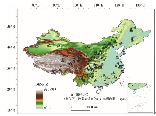
本文通过收集文献资料建立中国大陆CRI实测数据库,从而为中国大陆CRI模拟提供数据基础。自20世纪80年代以来,中国大陆地区CRI相关研究文献总计约300余篇,文献资料皆来自国内外知名学术期刊,通过剔除无实测CRI的研究文献及同一区域的重复性研究文献,在作进一步分析与评估的基础上,筛选出具有“采样设计合理、实验方法科学、数据科学可靠”等特点的CRI研究文献资料,均出自国内长期从事该方面研究的学者、单位,从而建立中国大陆CRI实测数据库。该数据库从80余篇文献或论文[18-100]中获取总计102个CRI实测数据,实测数据皆通过对研究地区未受干扰点的野外采样方法获得,数据结果科学可信。CRI采样点位及实测值可见(图1),CRI实测点位分布虽然并不均匀,且主要集中在黄土高原、四川盆地、云贵高原及内蒙古高原西南部等地,但基本能够覆盖中国大陆地区,满足进一步分析建模的基本条件。
土壤剖面中的Cs-137蓄积总量计算公式如下:
式中:CPI是采样点土壤剖面的Cs-137总量(Bq/m2),背景值采样点的CPI即为背景值;n为采样层数;i为层序号;Ci为第i采样层中Cs-137的比活度(Bq/kg);Bi为第i采样层的土壤容重(kg/m3);Di为第i采样层的厚度(m)。
Cs-137衰变校正公式,本文统一衰变校正至2015年1月1日:
式中:CPIN是衰变校正至第N年的Cs-137总量(Bq/m2);n是原参考文献中提供的第n年的CPI(Bq/m2);T是Cs-137的半衰期,为30.2年。
2.1.2 降水量数据
本文的降水量数据资料是来自全球降水气候中心(Global Precipitation Climatology Centre, GPCC)提供的1981-2010年月降水量再分析数据,其空间分辨率为2.5°×2.5°和0.5°×0.5°,该数据资料集源自全球气象观测站观测数据的再分析,并已通过质量检测(数据来源:http://www.esrl.noaa.gov/psd/data/gridded/reanalysis/)。
虽然该资料与本文的研究(1945-2015年)在时间尺度上并不相同,但是,该资料同时具有2.5°×2.5°、0.5°×0.5°分辨率降水量数据满足研究要求;并且,Aoyama等[17]在建模过程中也采用了1987-1998年2.5°×2.5°分辨率的降水量数据。因此,认为GPCC数据是目前最适合本研究的降水量数据集。
本文借鉴了Walling & He模型(Walling & He Model, WHM)及Michio Aoyama模型(Michio Aoyama Model, MAM),并作修正,从而建立了适用于中国大陆地区的CRI修正模型(Modified CRI Model for the Mainland of China, MCM)。WHM的建模方法是将全球划分为10°×45°网格,网格沉降总量由Garcia[12]提供的全球10°纬度带Cs-137沉降通量计算求得,网格内任意点CRI则利用其与降水量正相关关系求得[15]。WHM的优点是能够基于降水量的空间分布,实现全球任意点的CRI计算;而缺点是网格较大,且每个网格的沉降通量依托于模拟值。MAM基于全球713个采样点位的CRI实测数据,并将全球划分为10°×10°网格,假定相邻网格的CRI与降水量成正比,从而获得全球10°×10°网格的CRI空间分布[17]。与WHM相比,MAM网格分辨率明显提高,网格CRI计算依托于实测数据,相对准确。然而,MAM只能获得10°×10°网格准确的CRI数据,未能考虑网格内降水量分布情况,且网格空间尺度仍然较大,对区域性CRI模拟的精度仍然较低。
通过分析WHM和MAM,确定了MCM建模的三个基本原则:一是采用实测数据进行网格计算与模拟;二是网格内基于降水量分布计算任意点CRI;三是缩小网格空间尺度以适应区域性CRI研究。因此,MCM建模步骤如下:
第一步 建立2.5°×2.5°空间网格。首先将中国地区进行2.5°×2.5°网格化处理,中国大陆占据总计187个网格,将CRI实测数据库中的102个数据项导入,则占据52个网格。每个网格中的实测值个数范围在0~7个,平均每个网格中约有0.545个实测值,标准差系数范围在3.9%~66.8%。
第二步 假设相邻网格CRI与年均降水量正相关。众多研究表明,全球大气中Cs-137的沉降受主要受地球风带与气压带影响,相同纬度圈中Cs-137的大气沉降通量和降水量大致成正比[101-103]。假定经向相邻网格CRI与年均降水量正相关,并利用GPCC提供的1981-2010年2.5°×2.5°分辨率的降水量数据,计算中国大陆187个2.5°网格CRI。
对中国大陆任意第i行j列2.5°网格Ri, j,i = 1, 2, 3,…, 17,j = 1, 2, 3,…, 27。C(Ri, j)记为网格Ri, j处的CRI,P(Ri, j)记为网格Ri, j处的年均降水量,则有:
第三步 0.5°×0.5°网格化处理。对中国大陆进一步0.5°×0.5°网格化处理,由此每个2.5°网格被分为25个0.5°网格。本文认为2.5°网格内CRI是随降水量分布而均匀分布,0.5°网格的CRI可通过2.5°网格内25个0.5°网格的年均降水量关系求得。基于此,本文利用GPCC提供的1981-2010年0.5°×0.5°分辨率的降水量再分析数据,计算了中国地区0.5°网格CRI。
将每个Ri, j网格的0.5°网格记为为Ri, j rm, n,其中,m, n = 1, 2, 3, 4, 5。设中国大陆任一点X经纬度坐标为(φ, θ),φ范围为13.75~55.75°N,θ范围为71.25~137.25°E。点X所在0.5°网格为Ri, j rm, n,则有:
其中,
第四步 基于Kriging/Cokriging插值的任意点CRI计算。Kriging/Cokriging插值是地理地质作图中常用的一种最优内插法,它首先考虑的是空间属性在空间位置上的变异分布,确定对一个待插点值有影响的距离范围,从而实现线性、无偏和最小估计方差的估计。本文基于0.5°网格CRI计算结果作进一步Kriging/Cokriging插值处理,从而实现中国大陆任意点CRI模拟。
3.1.1 对实测点的模拟与评估
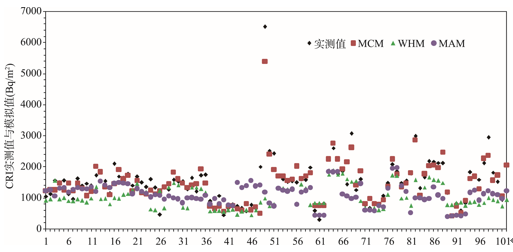
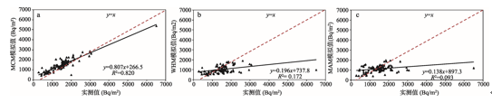
利用MCM、WHM、MAM三个模型对102个CRI实测点位进行模拟,并与实测值作对比分析,以评估模型的模拟效果(图2)。三个模型模拟结果与实测值分布趋势大致相同,且MCM模拟结果与实测值基本吻合,同一位置MCM模拟值或实测值基本高于WHM和MAM模拟值(图3)。对实测值与模拟值作统计分析可知(表1),针对中国大陆102个实测CRI,MCM模拟结果误差在20%以内有81个,占总数的近80%,而WHM和MAM误差在20%以内所占比例皆小于40%。与WHM和MAM模拟结果相比,MCM均方根误差相对较小,仅为其38%左右,表明MCM模拟值与实测值的偏差相对较小。Pearson相关分析可知,MCM模拟值与实测值的相关系数、复相关系数分别为0.906、0.821,在0.01水平(双侧)上显著正相关,且相关性远优于WHM和MAM模拟,而MAM模拟值与实测值的复相关系数仅为0.094。
表1 模拟值与实测值统计分析
Tab. 1 Statistical analysis of simulated and observed values
| 模型 | 误差20%内所占比例 | 均方根误差 | Pearson相关性 | 复相关系数R2 |
|---|---|---|---|---|
| MCM | 79.41% | 318.31 | 0.906** | 0.821 |
| WHM | 36.28% | 823.40 | 0.415** | 0.172 |
| MAM | 38.24% | 819.00 | 0.306** | 0.094 |
从三个模型对实测点的模拟结果来看,WHM、MAM模拟值对中国大陆地区的CRI模拟整体呈现偏小的特点,其主要原因可能是:WHM基于10°纬度带的1954-1984年全球沉降,并没有考虑1985年后的沉降,1986年的切尔诺贝利核事故也可能对Cs-137局部沉降造成一定的积累。MAM则基于全球713个采样点背景值数据,对1986年后的采样数据减去了切尔诺贝利核事故的影响值,并统一衰变校正至1969年底。1986年后的全球Cs-137沉降虽然相对较少,但两个模型皆由于研究时间、采样年份等因素限制并将其未加入模拟。
3.1.2 模型不确定性分析
与全球尺度的CRI模型如WHM、MAM相比,MCM能对中国大陆地区进行较高分辨率、较高精度的模拟,然而,模型仍旧存在一定的误差或不足。MCM基于现有的CRI实测数据进行模拟,但对中国大陆地区而言,实测点位数据仍然较少,且点位分布不均匀,主要集中在中部如四川盆地、黄土高原等地,而东部沿海及西北内陆地区则相对较少。本文采用的降水量数据来自再分析资料,经过数据同化处理的降水量可能与实际值存在一定的误差。
模型对采样点数据进行网格化处理,假定网格内CRI随降水量均匀分布,这可能对模拟结果产生一定误差。模型只考虑了降水量因素对CRI的影响,并未将地形及土壤条件、植被覆盖、土地利用类型等因素纳入考虑,可能造成模拟结果的偏大或偏小。此外,差值方法也可能对模型计算结果造成一定影响。
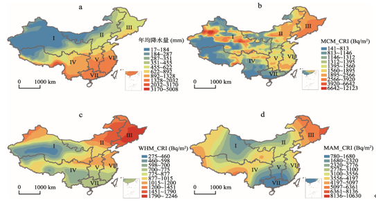
基于MCM,本文计算了中国大陆CRI的分布,图4a、4b分别展示了中国大陆年均降水量和CRI空间分布情况。本文将中国大陆分为西北地区(I)、华北地区(II)、东北地区(III)、西南地区(IV)、华中地区(V)、华东地区(VI)、华南地区(VII)等七个区,由图可知,中国大陆CRI的范围为141~12123 Bq/m2,CRI最大值位于I区新疆局部地区及III区,最小值区域则集中于VII区、IV区西部及南部地带及I区南部地区。除新疆局部地区外,中国大陆CRI分布整体呈现自西向东,同纬度地区随降水量增加而增加的特点,反映了从大陆性气候到季风性气候的过渡。I区大部分地区属于温带大陆性荒漠气候,年均降水量基本在50~150 mm之间,然而却在局部地区出现CRI最大值,一些研究表明[31, 35-36],这可能与中国地区20世纪六、七十年代在新疆罗布泊地区先后进行了一系列大气核试验有关。同时,该地区靠近乌克兰、哈萨克斯坦境内及俄罗斯北部新地岛附近的核试验点,且位于来自西北和北极地区的气团运动路径上,Cs-137干沉降或可造成区域性CRI的积累[104]。
图4 中国大陆降水量分布及基于MCM、WHM、MAM的CRI分布
Fig. 4 Distributions of precipitation and CRI (based on MCM, WHM and MAM simulations) in the Mainland of China
在全球范围内,土壤Cs-137浓度的区域性变化主要是降雨量分布不均的结果[105],而在0°~50°N范围内,Cs-137沉降量呈现随纬度增加而增加的特点[106]。图4c、4d分别展示了根据WHM和MAM计算的中国大陆CRI分布情况。WHM模拟结果显示,CRI最小值位于I区,最大值则与MCM、MAM模拟结果一致,都位于III区,体现了东北地区受风带气压带影响降水量较大而导致CRI较高,此外,Liu等研究表明东北地区沙尘暴的频率显著增加[107],沉降于地表的Cs-137再悬浮作用也可能导致东北地区CRI的积累[108],即当Cs-137沉降到土壤被细颗粒物质吸附后,当土壤受风力作用产生沙尘,Cs-137将随风力搬运形成再悬浮,从而携带更多的Cs-137沉降。MAM模拟结果的最小值主要位于VII区,与MCM模拟结果一致,这主要体现了纬度对Cs-137沉降量的影响。
整体而言,MCM模拟结果明显较WHM和MAM模拟结果的分辨率更高,且CRI模拟值也相对较高。宏观尺度上,CRI分布的不均匀性主要可能为气候条件、大尺度大气流场、地形及土壤条件、局部核试验或核泄漏等因素的综合影响[104]。区域尺度上(表2,图4),III区CRI总体高于II区,处于东部沿海地带的VI区总体高于处于内陆地带的V区及IV区,其可能原因是中国东部沿海地区由于海陆性质差异而形成的海陆间大气运动,大气运动可携带更多的Cs-137尘埃。此外,沿海地区易受台风影响[16],强大的台风气旋可富集其经过区域大气中的悬浮尘埃颗粒,因此台风降水可带来更多Cs-137沉降。
表2 中国大陆七大区域CRI变化
Tab. 2 CRI variance of seven regions in the Mainland of China
| 分区 | 区域名称 | MCM范围(Bq/m2) | WHM范围(Bq/m2) | MAM范围(Bq/m2) |
|---|---|---|---|---|
| I | 西北地区 | 214~12123 | 275~1321 | 1695~5240 |
| II | 华北地区 | 727~3035 | 629~1821 | 1830~5799 |
| III | 东北地区 | 1665~4096 | 1066~2246 | 3455~7120 |
| IV | 西南地区 | 141~5663 | 421~1066 | 1314~5601 |
| V | 华中地区 | 1292~2119 | 697~1096 | 1112~3563 |
| VI | 华东地区 | 875~2382 | 712~1210 | 1081~4115 |
| VII | 华南地区 | 231~1721 | 562~782 | 1152~1881 |
(1)基于102个CRI实测资料,建立了中国大陆CRI实测数据库,并通过借鉴前人的研究模型建立适用于中国大陆地区的CRI修正模型,从而实现了区域性CRI的模拟。本文基于实测数据及网格化建模进行区域性CRI研究的方法,或可成为今后CRI研究的一种行之有效的手段。
(2)运用MCM、WHM、MAM三个模型对实测点的模拟结果表明,MCM模拟值与实测值基本吻合,WHM和MAM模拟明显小于实测值和MCM模拟值,这可能与WHM和MAM皆未考虑1985年后的Cs-137沉降有关。整体而言,MCM对中国大陆CRI模拟效果相对较好,模拟的分辨率、精度皆有较大提高,且对中国大陆的适用性较好。而模型的误差主要来自于采样点位分布的不均匀性与低密度特征,今后或可通过增加均匀采样点位的方法完善模型结果。此外,空间插值方法以及基于数据同化的降水量再分析数据对模拟的结果也可产生一定影响。
(3)中国大陆CRI分布主要受气候条件、大尺度大气流场、地形及土壤条件、局部核试验或核泄漏等因素的综合影响。基于MCM的中国大陆CRI的范围为141~12123 Bq/m2,除新疆局部地区外,中国大陆CRI分布整体呈现自西向东,同纬度地区随降水量增加而增加的特点。从纬向分布看,CRI主要呈现同等或相似降水量条件下,随纬度增加而增加的特点。此外,局部大气核试验、Cs-137再悬浮过程也可能对中国大陆CRI分布造成一定影响。
(4)通过探讨中国大陆CRI及其分布特征,一方面,可为中国大陆地区进一步开展CRI研究提供参考与借鉴;另一方面,随着中国大陆地区土壤侵蚀、水土流失等环境问题的日益严重,也可为进一步定量研究中国大陆地区土壤侵蚀和堆积,以及区域物质输移和沉积物示踪提供科学基础。
The authors have declared that no competing interests exist.
| [1] |
US soil erosion rates: Myth and reality . |
| [2] |
703) .
|
| [3] |
Environmental and economic costs of soil erosion and conservation benefits. Science-AAAS-
|
| [4] |
Post-wildfire soil erosion in the Mediterranean: Review and future research directions .
|
| [5] |
A faster numerical scheme for a coupled system modeling soil erosion and sediment transport . |
| [6] |
Assessment of soil erosion and sedimentation: The role of fallout radionuclides . |
| [7] |
National Soil Degradation Maps, Soil Degradation Map of Austria. FAO/AGL . |
| [8] |
Hakkeling R T A, Sombroek W G. World map of the status of human-induced soil degradation: An explanatory note .
|
| [9] |
GLASOD-SOTER Newsletter. Wageningen, |
| [10] |
Street-Perrott F A, Burt T P. Climate change and soil erosion . |
| [11] |
200) . |
| [12] |
Global distribution of 137Cs inputs for soil erosion and sedimentation surveys. International Atomic Energy Authority (IAEA). Use of 137Cs in the study of soil erosion and sedimentation. IAEA-TECDOC-1028, |
| [13] |
|
| [14] |
Prediction of 137Cs deposition from atmospheric nuclear weapons tests within the Arctic . |
| [15] |
The global distribution of bomb-derives 137Cs reference inventories . |
| [16] |
137Cs reference inventories distribution pattern in China .中国137Cs本底值区域分布研究 . |
| [17] |
Re-construction and updating our understanding on the global weapons tests 137Cs fallout . |
| [18] |
Use of 137Cs method to sediment source in the Loess Plateau watershed .黄土高原小流域泥砂来源的137Cs法研究 . |
| [19] |
1): 21-22 ,
1): 21-22 ,
|
| [20] |
Soil erosion and sediment transportation of the loess hilly and slope land .
黄土峁坡耕地土壤侵蚀与泥沙输移 .
|
| [21] |
Using Cesium-137 technique to study the characteristics of different aspect of soil erosion in the Wind-water Erosion Crisscross Region on Loess Plateau of China .
|
| [22] |
Li Shaolong et al. A study on 137Cs method used in controlling erosion on the Loess Mao and slopes .
黄土峁坡侵蚀137Cs法研究 .
|
| [23] |
Spatial patterns of soil erosion on steep cultivated hillslope in Loess Plateau of northern Shanxi .
陕北黄土高原陡坡耕地土壤侵蚀变异的空间格局 .
|
| [24] |
Spatial distribution of soil erosion on different utilization soils in Yangou watershed by using 137Cs tracer .
小流域不同土地利用方式土壤侵蚀分异的137Cs示踪研究 .
|
| [25] |
Study of soil erosion on cultivated slope land in severe soil loss regions of upper reaches of Yangtze River Basin using 137Cs technique .
长江上游重点水土流失区坡耕地土壤侵蚀的137Cs法研究 .
|
| [26] |
Study on 137Cs method used in soil erosion and sediment delivery on sloping fields in gully area on Loess Plateau .
黄土高原沟壑区谷坡农地侵蚀及产沙的137Cs法研究 .
|
| [27] |
|
| [28] |
Determination of surface erosion in purple hilly area of small watershed in the upper reaches of the Yangtze River .
长江上游紫色土丘陵区小流域地面侵蚀量的确定 .
|
| [29] |
|
| [30] |
Estimating erosion rates on sloping agricultural land in the Yangtze Three Gorges, China, from caesium-137 measurements .
|
| [31] |
Levels of 137Cs and 90Sr in soil around the nuclear test field of Xinjiang .新疆核试验场周围土壤中90Sr和137Cs水平 . |
| [32] |
|
| [33] |
Preliminary results of wind erosion in the Tibetan Plateau using 137Cs method .
137Cs法测定青藏高原土壤风蚀的初步结果 .
|
| [34] |
Soil erosion rate using 137Cs technique in the middle Yalungtsangpo .
雅鲁藏布江中游地区土壤侵蚀的137Cs示踪法研究 .
|
| [35] |
|
| [36] |
Preliminary study on the potential of using 137Cs to estimate soil erosion rates in wind erosion area, China: Case study on the Korla area, Xinjiang autonomous region .137Cs应用于我国西部风蚀地区土地退化的初步研究: 以新疆库尔勒地区为例 . |
| [37] |
The application of the new methods of land degradation study: A case study on Dongxi River Basin, Western Fujian, China .
土地退化方法应用初步研究: 以闽西沙县东溪流域为例 .
|
| [38] |
Primary estimate on soil loss amounts in Yangtse Delta region using 137Cs technique .
137Cs技术对长江三角洲丘陵区小流域土壤侵蚀初步估算 .
|
| [39] |
Preliminary estimate of soil erosion rate in Haplic red soil in southern China using 137Cs technique .
137Cs法估算南方红壤地区土壤侵蚀作用的初步研究 .
|
| [40] |
Soil erosion and nutrient loss of various land use patterns .
不同土地利用方式下农地土壤侵蚀与养分流失 .
|
| [41] |
Preliminary study on using 137Cs tracer method to estimate soil erosion of typical area: A case study on Xitiaoxi drainage area at up stream of Taihu Lake Basin .
137Cs法用于典型流域土壤侵蚀的初步研究: 以太湖流域上游西苕溪流域为例 .
|
| [42] |
137Cs reference site characteristics in Hong Kong: Some considerations. Physics and Chemistry of the Earth,
|
| [43] |
Study on reference Cesium-137 inventory of black soil in Northeast China .
东北黑土中137Cs背景值研究 .
|
| [44] |
Application of 137Cs as tracing method to study soil erosion on sloping lands in the hilly red soil area: A case study in Fengcheng City, Jiangxi Province .
137Cs示踪红壤丘陵区坡地土壤侵蚀的研究: 以江西丰城市为例 .
|
| [45] |
Soil erosion and organic matter loss by using fallout 137Cs as tracer in Miyun Reservoir Valley .
基于土壤137Cs监测的土壤侵蚀与有机质流失: 以密云水库为例 .
|
| [46] |
Evaluating soil erosion rate in the Dianchi Lake Basin using 137Cs tracer method .
137Cs示踪法估算滇池流域土壤侵蚀 .
|
| [47] |
Using 137Cs tracer technique to evaluate erosion and deposition of black soil in Northeast China .
|
| [48] |
Distribution characteristics of 137Cs in wind-eroded soil profile and its use in estimating wind erosion modulus .
|
| [49] |
Modern geomorphic processes of Three Gorges Reservoir Area: A case study of modern slope process in the Caotang River Basin [D].
三峡库区现代地貌过程研究: 以草堂河流域现代坡地过程研究为例 [D].
|
| [50] |
|
| [51] |
Distribution characteristics of 137Cs in wind-eroded soil profile and its use in estimating wind erosion modulus .
|
| [52] |
Relationship between 137Cs concentration and cultivated history on loessial hillslopes .
黄土坡面137Cs浓度与坡面耕垦历史的关系研究 .
|
| [53] |
Application of 137Cs tracer technique to estimate the wind erosion rate of Castanozem in Luanhe River Source Area .
137Cs示踪技术在滦河源区栗钙土风蚀速率估算中的应用 .
|
| [54] |
|
| [55] |
Study on soil erosion rates in the Three Gorges Reservoir area using 137Cs tracing method .
137Cs示踪三峡库区土壤侵蚀速率研究 .
|
| [56] |
137Cs trace technique to study soil erosion at alpine meadow of Tibetan Plateau .
137Cs示踪法研究青藏高原草甸土的土壤侵蚀 .
|
| [57] |
Study on effect of landform positions and land use types on soil erosion and sedimenty yield by 137Cs tracer in small catchment .
小流域地貌部位和土地利用类型对侵蚀产沙影响的137Cs法研究 .
|
| [58] |
|
| [59] |
On the source of radioisotope 137Cs in the surface sediments of Lake Qinghai .
青海湖表层底泥中放射性同位素137Cs的来源 .
|
| [60] |
Influence of land use/cover change on soil surface erosion/deposition process: evidence from 137Cs as a tracer .
土地利用/覆盖变化对地表蚀积过程的影响: 来自137Cs示踪的证据 .
|
| [61] |
Estimation of wind erosion rates by using 137Cs tracing technique: A case study in Tariat-Xilin Gol transect, Mongolian Plateau .
|
| [62] |
137Cs distribution and its reference Inventory in rocky desertification land in North Guangdong .
粤北石漠化地区137Cs分布特征与背景值研究 .
|
| [63] |
Study on the law of soil degradation in Karst Environment [D].
岩溶环境中土壤退化规律研究 [D].
|
| [64] |
Using 137Cs tracer technique to investigate soil erosion distribution and total erosion amount in Taihu Lake catchment .
137Cs示踪法研究太湖流域土壤侵蚀分布与总量 .
|
| [65] |
Study on the spatial variability of soil erosion tracer using 137Cs [D].
137Cs土壤侵蚀示踪空间变异研究 [D].
|
| [66] |
Using 137Cs tracing technique to estimate wind erosion rates in the typical steppe region, northern Mongolian Plateau .
|
| [67] |
The distribution of 137Cs in the hilly upland soil of the Qianzhong Karst Plateau .
黔中高原岩溶丘陵坡地土壤中的137Cs分布 .
|
| [68] |
Evaluating soil erosion and organic matter loss in the Danjiangkou City using 137Cs tracing method .
基于137Cs示踪的丹江口市农用地土壤侵蚀与有机质流失分析 .
|
| [69] |
Study of soil erosion on slope farmland in the karst area of the Zhongliang Mountains by 137Cs technique .
中梁山岩溶区坡耕地土壤侵蚀137Cs法研究 .
|
| [70] |
Use of 137Cs to soil erosion in Chenggong region, Yunnan Province [D].
云南呈贡地区土壤侵蚀的137Cs示踪研究 [D].
|
| [71] |
The spatial variance of hill slope erosion in Loess Hilly Area by 137Cs tracing method .
137Cs示踪法研究黄土丘陵区坡面侵蚀空间变化特征 .
|
| [72] |
137Cs distribution characteristics at a Talus-type Karst slope in Northwestern Guangxi .
桂西北倒石堆型岩溶坡地土壤的137Cs分布特点 .
|
| [73] |
|
| [74] |
Soil erosion law based on Cs-137 tracer method in typical slope, Tiantai County, Zhejiang Province .
用Cs-137示踪法研究浙江天台县典型坡面的土壤侵蚀规律 .
|
| [75] |
Sampling numbers and area for the confirmation of 137Cs reference inventory .
确定137Cs背景值所需的采样点数与采样面积 .
|
| [76] |
|
| [77] |
Effects of land use change on soil erosion intensity in small watershed of Loess Hilly region: a quantitative evaluation with 137Cs tracer .
黄土丘陵小流域土地利用变化的土壤侵蚀效应: 基于137Cs示踪的定量评价 .
|
| [78] |
Soil 137Cs background values in monsoon region of China .
中国季风区土壤137Cs背景值研究 .
|
| [79] |
|
| [80] |
|
| [81] |
Research on land degradation of Mongolia Plateau based on conventional analysis and isotopic 137Cs Technology [D].
基于土壤常规分析和同位素137Cs技术的蒙古高原土地退化研究 [D].
|
| [82] |
|
| [83] |
Soil erosion of agro pastoral zone in northern China based on 137Cs Technology [D].
基于137Cs技术的中国北方农牧交错带土壤侵蚀研究 [D].
|
| [84] |
Estimation of soil erosion in the Xihanshui River Basin by using 137Cs technique .
|
| [85] |
Yan Baixing, Zhu Hui. Estimating soil erosion in Northeast China using 137Cs and 210Pb_ex .
|
| [86] |
Current status and comprehensive control strategies of soil erosion for cultivated land in the Northeastern black soil area of China .
东北黑土区农地水土流失现状与综合治理对策 .
|
| [87] |
137Cs quantitative analysis of soil erosion in the typical alpine meadow in the Three-River Headwaters region .
三江源区典型高寒草甸土壤侵蚀的137Cs定量分析 .
|
| [88] |
Analysis of soil erosion rules of typical mountain along Taihu Lake Basin using 137Cs-based tracer method .
基于137Cs示踪法的太湖流域典型山地土壤侵蚀规律分析 .
|
| [89] |
137Cs reference inventory and its distribution in soils along the Liaodong Bay .
辽东湾沿岸土壤中137Cs背景值及分布特征研究 .
|
| [90] |
The characteristics of 137Cs deposition in the dry steppe region .
干草原地区土壤137Cs沉积特征 .
|
| [91] |
Determination of 137Cs reference inventories in a large-scale region: A case study in the central-eastern Inner Mongolia Plateau .
|
| [92] |
137Cs inventories and soil organic carbon content in soils of three typical terrestrial ecosystems .
3种典型陆地生态系统土壤137Cs和有机碳含量研究 .
|
| [93] |
137Cs tracing technique to study soil erosion between upper Huangshui Basin and lower Buha River Basin .
137Cs示踪法研究湟水上游和布哈河下游区域土壤侵蚀强度 .
|
| [94] |
|
| [95] |
Characterization and evaluation of agricultural soil erosion in Shenzhen City using environmental radionuclides .
基于核示踪的深圳市农用土壤侵蚀特征及评价 .
|
| [96] |
Study on soil erosion features of small catchment of karst plateau wetland by 137Cs tracing technology .
137Cs技术研究岩溶高原湿地小流域土壤侵蚀特征 .
|
| [97] |
Using 137Cs technique to study soil erosion in Chishui River region .
赤水河流域不同土地利用类型土壤侵蚀的137Cs法研究 .
|
| [98] |
Spatial differentiation of soil erosion on typical loess hill slope loess hilly and gully region .
黄土丘陵区典型峁坡土壤侵蚀空间分异特征 .
|
| [99] |
137Cs tracing of soil erosion and its impact on soil nutrients across subsidence slope induced by coal mining .
137Cs示踪采煤沉陷坡土壤侵蚀及其对土壤养分的影响 .
|
| [100] |
137Cs Reference Inventory and its distribution in surface soil along the Fangchenggang coastal zone of Beibu Gulf .北部湾防城港沿岸土壤137Cs背景值及表层分布特征研究 . |
| [101] |
|
| [102] |
Prediction of 137Cs deposition from atmospheric nuclear weapons tests within the Arctic .
|
| [103] |
Prediction of spatial variation in global fallout of 137Cs using precipitation . |
| [104] |
Reference value of 137Cs tracing technique in soil loss estimation: A spatial variation analysis .137Cs示踪法土壤侵蚀量估算的本底值问题 . |
| [105] |
McIntyre S C, Naney J W, et al. Measuring sediment movement at low erosion rates using cesium-137 . |
| [106] |
Soil geochemistry characteristics of 137Cs and its theory of tracing soil erosion .137Cs的土壤地球化学及其侵蚀示踪意义 . |
| [107] |
Analyses of the spring dust storm frequency of northern China in relation to antecedent and concurrent wind, precipitation, vegetation, and soil moisture conditions. Journal of Geophysical Research: |
| [108] |
137Cs atmospheric deposition in the Liaodong Bay .辽东湾地区137Cs大气沉降研究 . |

/
| 〈 |
|
〉 |