
中国边境口岸地缘风险模型构建与评估
|
程艺(1992-), 女, 四川广安人, 博士, 助理研究员, 研究方向为边境地理、地缘政治。E-mail: chengy.14s@igsnrr.ac.cn |
收稿日期: 2024-02-22
修回日期: 2024-12-02
网络出版日期: 2025-04-23
基金资助
第二次青藏高原科学考察研究(2019QZKK1007)
中国科学院战略性先导科技专项(XDA20010103)
中国科学院地理科学与资源研究所所长基金项目(E3W30090YZ)
Model construction and assessment for geo-risk at China's border ports
Received date: 2024-02-22
Revised date: 2024-12-02
Online published: 2025-04-23
Supported by
The Second Tibetan Plateau Scientific Expedition and Research Program(2019QZKK1007)
Strategic Priority Research Program of the Chinese Academy of Sciences(XDA20010103)
Director Fund for Institute of Geographic Sciences and Natural Resources Research, CAS(E3W30090YZ)

程艺 , 刘慧 . 中国边境口岸地缘风险模型构建与评估[J]. 地理学报, 2025 , 80(4) : 905 -920 . DOI: 10.11821/dlxb202504004
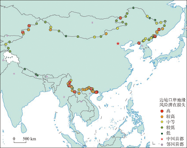
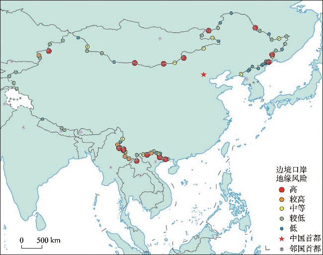
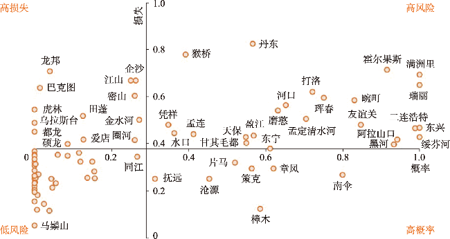
Border ports serve as critical frontlines against potential threats from neighboring countries, with their risk status directly impacting national security and the livelihoods of local residents and businesses. Despite this importance, there remains a lack of quantitative assessments of geo-risk at these border ports. This study addresses this gap by constructing a geo-risk assessment model based on the concepts of probability and potential loss. By integrating multi-source spatio-temporal data, the geo-risk at border ports is estimated for type classification and feature analysis. The results reveal several key findings: geo-risk stress is gradually shifting westward, with significant accumulation at southwestern border ports, and comprehensive border ports are experiencing heightened risk. Geo-risk probability is high at China-Myanmar and China-Vietnam border ports, with notable risks at northern transit node ports, and Ruili ranks highest in geo-risk probability among all ports. Potential losses are concentrated along the southern border, especially at critical nodes of external transit routes and ports along the Belt and Road. The overall spatial distribution of geo-risk at border ports follows a pattern of "dense in the south, sparse in the north, and balanced across multiple points,"with risks categorized into four types: high risk, high probability, high loss, and low risk, with approximately one-quarter of ports categorized as high-risk. This study enhances the understanding of border risk, and the constructed geo-risk assessment model provides a valuable reference for risk quantification in other countries or regions while offering a scientific basis for decision-making related to border security.
Key words: border ports; geo-risk; national security; geo-field; China
表1 邻国国家尺度地缘风险压力评估指标体系Tab. 1 National-scale geo-risk stress assessment indicator system |
| 准则层 | 指标层 | 权重 | 单位 | 作用方向 | 指标说明 | 数据来源 |
|---|---|---|---|---|---|---|
| 政治 风险 | 军费支出占GDP比重 | 0.225 | % | 正 | 反映国家军事扩张意图 | 世界银行 |
| 政治稳定程度 | 0.217 | - | 负 | 反映国家的政权稳定性 | 全球治理指数 | |
| 经济 风险 | 国家外债占GDP比重 | 0.095 | % | 正 | 即外债总额占GDP之比,反映国家经济发展对外债的依赖程度 | 世界银行、国际货币基金组织 |
| 通货膨胀率 | 0.056 | % | 正 | 反映国家物价变动水平 | 国际货币基金组织、世界银行 | |
| 对外贸易依存度 | 0.075 | % | 正 | 即进出口总额/GDP,反映国家的经济依赖于对外贸易的程度 | 联合国贸易和发展会议 | |
| 社会 风险 | 犯罪率 | 0.102 | % | 正 | 每十万人杀人犯罪率,反映国家犯罪事件发生强度 | 联合国开发计划署 |
| 失业率 | 0.074 | % | 正 | 反映国家的就业情况 | 世界银行 | |
| 基尼系数 | 0.047 | % | 正 | 反映社会贫富差距 | 世界银行 | |
| 生态 风险 | 自然灾害死亡人数 | 0.078 | 人 | 正 | 反映自然灾害损害情况 | 灾害流行病学研究中心(EM-DAT) |
| 自然灾害估计经济损害 | 0.031 | 美元 | 正 | 反映自然灾害损害情况 | 灾害流行病学研究中心(EM-DAT) |
表2 邻国栅格尺度地缘风险压力评估指标体系Tab. 2 Grid-scale geo-risk stress assessment indicator system |
| 准则层 | 指标层 | 权重 | 单位 | 作用方向 | 指标说明 | 数据来源 |
|---|---|---|---|---|---|---|
| 政治 风险 | 武装冲突事件数量 | 0.103 | 次 | 正 | 反映地区的恐怖主义形势 | 全球恐怖主义数据库(UCDP)和ACLED冲突数据集 |
| 军事演习频次 | 0.188 | 次 | 正 | 反映邻国军事演习对本国边境地区形成的风险 | 全球新闻媒体事件库(GDELT) | |
| 争议边界线10 km 缓冲区范围 | 0.151 | km2 | 正 | 具有争议的国界线产生的风险,仅考虑中国与印度、中国与不丹的争议边界。 | 根据公开资料整理。考虑到历史敏感性以及官方史料缺乏,中国与邻国已经确定的历史争议边界并未纳入计算范围 | |
| 经济 风险 | 地缘经济风险程度 | 0.226 | - | 正 | 反映地区的地缘经济风险程度,经数据计算和空间定位处理 | 全球新闻媒体事件库(GDELT) |
| 社会 风险 | 民族动荡性程度 | 0.094 | - | 正 | 全球种族分布及民族动荡性数据 | 少数民族权利关系(GeoEPR)和少数民族风险(MAR)数据库 |
| 恐怖主义危害度 | 0.129 | - | 正 | 恐怖主义事件中危害性衡量,以(死亡+受伤人数)/发生频次计算表示 | 全球恐怖主义数据库(GTD) (1970—2020年) | |
| 生态 风险 | 灾害发生频次 | 0.109 | 次 | 正 | 反映自然灾害发生情况 | 地理定位的灾害数据集(GDIS)和灾害流行病学研究中心(EM-DAT) |
表3 口岸地缘风险潜在损失评估指标体系Tab. 3 Assessment indicator system for potential losses of geo-risks at border ports |
| 准则层 | 指标层 | 权重 | 单位 | 指标说明 | 数据来源 |
|---|---|---|---|---|---|
| 人口损失 | 常住人口数量 | 0.331 | 人 | 边境口岸所在县级城市的常住人口数量 | 第七次全国人口普查数据 |
| 经济损失 | GDP | 0.272 | 万元 | 边境口岸所在县级城市的经济生产总值之和 | 《县域统计年鉴》 |
| 地缘战略损失 | 边境口岸地缘 战略价值 | 0.397 | 综合评价 指标 | 多维度综合评价的边境口岸地缘战略优势度 | 数据论文《丝绸之路经济带陆路边境口岸城市地缘战略优势度综合评估》 |
| [1] |
[胡志丁, 骆华松, 李灿松, 等. 地缘安全视角下国家边界的“三重功能”及其优化组合. 人文地理, 2012, 27(3): 73-77.]
|
| [2] |
|
| [3] |
|
| [4] |
|
| [5] |
|
| [6] |
[程艺. 中国边境地区地缘风险的时空分异与影响机制研究[D]. 北京: 中国科学院大学, 2023.]
|
| [7] |
|
| [8] |
|
| [9] |
|
| [10] |
|
| [11] |
|
| [12] |
Wohlgemut E: Porous Borders: Maria Edgeworth and the Question of National Identity. London: Palgrave Macmillan UK, 2009: 71-94.
|
| [13] |
[朱金春. 从“国家之边缘”到“边界为中心”: 全球化视野下边境研究的议题更新与范式转换. 广西民族研究, 2019(1): 65-74.]
|
| [14] |
[方铁. 古代“守中治边”“守在四夷”治边思想初探. 中国边疆史地研究, 2006, 16(4): 1-8, 147.]
|
| [15] |
[程艺, 刘慧, 宋涛, 等. 人文地理学视域下中国边境地区研究进展与展望. 地理科学进展, 2022, 41(10): 1940-1955.]
|
| [16] |
|
| [17] |
[张红梅. 基于地缘环境视角的云南边境地区旅游安全评价研究[D]. 昆明: 云南财经大学, 2020.]
|
| [18] |
[程艺, 刘慧, 张芳芳. 中国边境口岸地区传染病境外输入风险评估: 以新冠疫情为例. 地理研究, 2022, 41(3): 851-866.]
|
| [19] |
[徐君, 薄辉龙. “一带一路”背景下西藏吉隆口岸社会治理风险研究. 青海民族研究, 2019, 30(4): 74-79.]
|
| [20] |
[彭绍华. 新疆霍尔果斯口岸社会风险治理研究[D]. 武汉: 中南民族大学, 2016.]
|
| [21] |
[刘丰, 于珊珊, 马晓光. 口岸传染病风险预警与快速决策信息系统的开发与建立. 中国国境卫生检疫杂志, 2011, 34(1): 52-55.]
|
| [22] |
[许丽波, 刘丰, 孙丽萍, 等. 口岸传染病风险评估指标体系建立的研究. 中国国境卫生检疫杂志, 2011, 34(3): 197-199.]
|
| [23] |
|
| [24] |
|
| [25] |
World Economic Forum. Global Risks 2015. (2015-01-09) [2022-04-10]. https://www.weforum.org/publications/global-risks-2015/.
|
| [26] |
[郗笃刚, 刘建忠, 周桥, 等. “一带一路”建设在印度洋地区面临的地缘风险分析. 世界地理研究, 2018, 27(6): 14-23.]
|
| [27] |
[李飞, 成升魁, 于会录, 等. 国家地缘脆弱性探索: 缅甸案例及对中国地缘战略启示. 地理科学进展, 2016, 35(6): 737-746.]
|
| [28] |
[洪菊花, 骆华松, 梁茂林, 等. “一带一路”重大项目地缘风险研究. 人文地理, 2018, 33(1): 130-136.]
|
| [29] |
[吴绍洪, 潘韬, 刘燕华, 等. 中国综合气候变化风险区划. 地理学报, 2017, 72(1): 3-17.]
|
| [30] |
[史培军. 三论灾害研究的理论与实践. 自然灾害学报, 2002, 11(3): 1-9.]
|
| [31] |
|
| [32] |
[孙绍骋. 灾害评估研究内容与方法探讨. 地理科学进展, 2001, 20(2): 122-130.]
|
| [33] |
[杨柳林, 王雪梅, 陈巧俊. 区域间大气污染物相互影响研究的新方法探讨. 环境科学学报, 2012, 32(3): 528-536.]
|
| [34] |
[熊琛然. 大国地缘战略交汇区地缘关系研究: 以中南半岛为例[D]. 北京: 中国科学院大学, 2020.]
|
| [35] |
[黄金川, 孙贵艳, 闫梅, 等. 中国城市场强格局演化及空间自相关特征. 地理研究, 2012, 31(8): 1355-1364.]
|
| [36] |
|
| [37] |
[黄崇福, 张俊香, 刘静. 模糊信息优化处理技术应用简介. 信息与控制, 2004, 33(1): 61-66.]
|
| [38] |
[宋涛, 程艺, 刘卫东, 等. 中国边境地缘经济的空间差异及影响机制. 地理学报, 2017, 72(10): 1731-1745.]
|
| [39] |
[刘海猛, 胡森林, 方恺, 等. “一带一路”沿线国家政治—经济—社会风险综合评估及防控. 地理研究, 2019, 38(12): 2966-2984.]
|
| [40] |
[邢广程. 周边、周边外交与中国边疆. 中国边疆史地研究, 2018, 28(3): 1-11, 212.]
|
| [41] |
[陈小强, 袁丽华, 沈石, 等. 中国及其周边国家间地缘关系解析. 地理学报, 2019, 74(8): 1534-1547.]
|
/
| 〈 |
|
〉 |