
秦岭北麓峪道空间发育特征与水系承袭关系
|
申艳军(1984-), 男, 河南安阳人, 教授, 博士生导师, 主要从事工程地质与生态地质研究。E-mail: shenyj@chd.edu.cn |
收稿日期: 2024-02-22
修回日期: 2024-11-06
网络出版日期: 2025-01-21
基金资助
国家自然科学基金项目(42341101)
国家自然科学基金项目(42341102)
中央高校基本科研业务费资助项目(300102263401)
Spatial development characteristics of the valley roads and inheritance relationship with water system at the northern foothills of the Qinling Mountains
Received date: 2024-02-22
Revised date: 2024-11-06
Online published: 2025-01-21
Supported by
National Natural Science Foundation of China(42341101)
National Natural Science Foundation of China(42341102)
Basic Scientific Research Business Funds of Central Universities(300102263401)
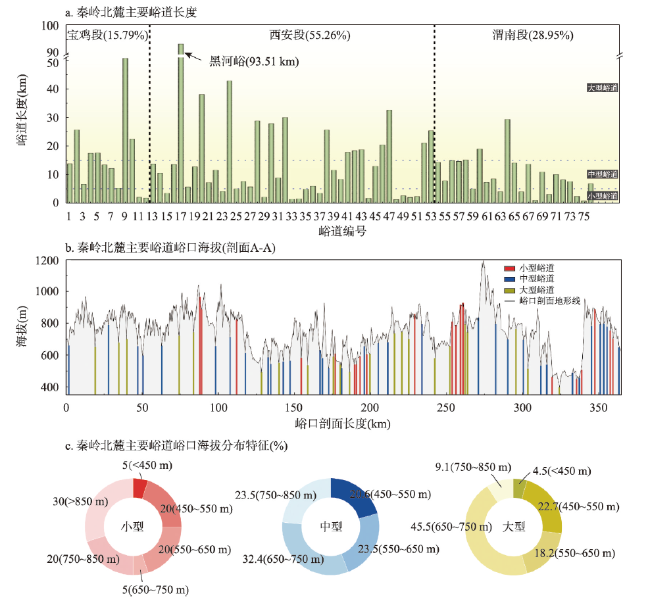
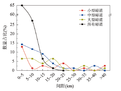
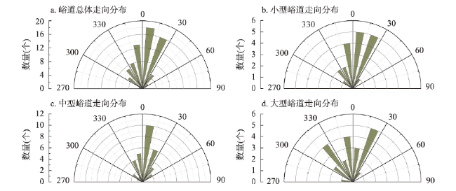
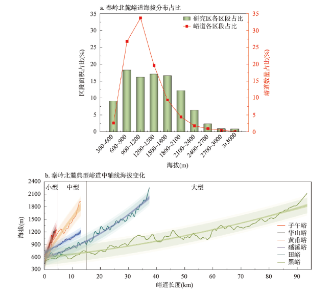
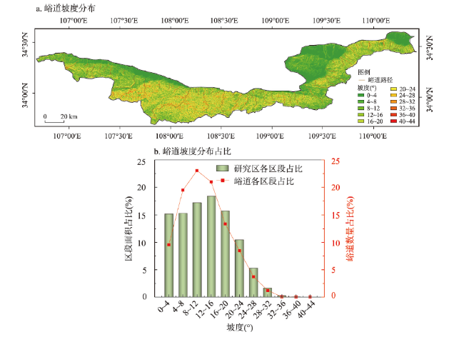
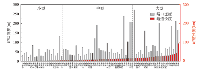
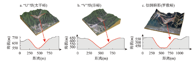
秦岭北麓峪道深切秦岭主脉,是洞察秦岭地质、地貌、生态与水文演化的“天然窗口”。据此,本文利用Google Earth遥感影像、DEM数据及水系矢量数据,结合ArcGIS、GlobalMapper等多模态空间识别与数据解译,获得秦岭北麓峪道空间分布与发育特征,并探究其与关中水系承袭关系。研究结果表明:① 依据峪道地貌、长度、道路及水系提出峪道统计标准,并结合等高线地形、数字海拔模型进行区划判读,统计出峪道实际为206条;② 基于遥感解译可视性和峪内存在水系原则,抽取76条代表性峪道统计,按照长度≥15 km、5~15 km、<5 km划分大、中、小型峪道,西安段发育最为密集,以中型峪道为主(44.74%);③ 峪道走向多为N0°~NE30°,与汾渭断陷走向近似垂直;峪口海拔呈正态分布,集中于500~800 m之间;峪道间距呈“大峪夹小峪”韵律分布;④ 峪道中线海拔为600~1500 m,坡度为0°~20°,峪口宽度为30~90 m,峪口形态多为“U”型、“V”型及倒梯形;⑤ 秦岭北麓峪道与渭河水系具有密切承袭关系,“长安八水”之六发源于秦岭北麓,呈“多源汇流”特点。研究结果可为秦岭标志性地理标签—峪道研究提供本底数据支撑。
申艳军 , 马天驰 , 彭建兵 , 钱会 , 段丰浩 , 徐盼盼 , 陈思维 , 王瑞 , 宁奕冰 , 穆青翼 , 沈伟 , 成玉祥 , 师百垒 . 秦岭北麓峪道空间发育特征与水系承袭关系[J]. 地理学报, 2025 , 80(1) : 132 -146 . DOI: 10.11821/dlxb202501009
The valley roads at the northern foothills of the Qinling Mountains deeply cut the main chain of the Qinling Mountains, and are the "natural window" to gain insight into the geology, geomorphology, ecology and hydrological evolution of the Mountains. In this paper, the spatial distribution pattern and development characteristics of the valley roads at the northern foothills of the Qinling Mountains (Shaanxi section) were obtained by using Google Earth remote sensing image data, DEM elevation data and water system vector data, combined with ArcGIS, GlobalMapper multimodal spatial data identification and interpretation. The inheritance relationship between the valley roads at the northern foothills of the Qinling Mountains and the Guanzhong river system was explored. The following understandings were obtained: (1) According to the geomorphological characteristics of the valley roads, the length, pedestrian and water channel, the statistical standard of the valley roads was put forward. Combined with contour terrain and digital elevation model, the zoning interpretation is carried out, and the actual number of valley roads is 206. (2) Based on the visibility of remote sensing interpretation and the endowment water system in the valley roads, 76 representative valley roads were selected for statistical analysis. According to the length (≥15 km, 5-15 km, <5 km), the large, medium and small valley roads were divided. The Xi'an section is the most densely developed mainly for medium valley road (44.74%). (3) The direction of the valley roads is mostly N0°-NE30°, approximately perpendicular to the strike of the Fenwei Fault. The elevation of Yukou is normally distributed, concentrated between 500-800 m. The spacing between the valley roads is the rhythmic distribution of "small valley roads in big valley roads". (4) The elevation of the middle line of the valley roads is mainly distributed at 600-1500 m, the slope is mainly concentrated at 0°-20°, the width of the valley entrances are mainly at 30-90 m, and the shape of the valley entrances are mainly U-shaped, V-shaped and inverted trapezoidal. (5) The valley roads at the northern foothills of the Qinling Mountains and Weihe water system have a close inheritance relationship. Six of the "Eight River Systems in Chang'an" originated from the northern foothills of the Qinling Mountains, characterized by multi-source confluence. The purpose of this study is to provide detailed background data for the study of the most iconic geological and geographical labels in the Qinling Mountains with valley roads.
表1 秦岭北麓峪道数量及名录考究一览表(由西至东)Tab. 1 The list of number and valley roads at the northern foothills of the Qinling Mountains (from west to east) |
| 市名称及 总数量(条) | 区/县名称 | 数量(条) | 峪道名称 |
|---|---|---|---|
| 宝鸡市 (35) | 陈仓(西) | 8 | 仙龙峪、大水峪、马宗山峪、林光峪、黑湾峪、巍子峪、青沟峪、安平峪 |
| 渭滨 | 11 | 晁峪、甘峪、太寅峪、清姜峪、濛峪、瓦峪、石坝峪、高家峪、茵香峪、洙峪、清水峪 | |
| 陈仓(东) | 4 | 马尾峪、磻溪峪、伐鱼峪、雍峪 | |
| 岐山 | 2 | 同峪、麦李峪 | |
| 眉县 | 10 | 斜峪、铜峪、罗峪、红河峪、大黑峪、小黑峪、远门峪、滑峪、西汤峪、大镇峪 | |
| 西安市 (88) | 周至 | 23 | 泥峪、竹峪、车峪、强峪、稻峪、西骆峪、辛口峪、熨斗峪、虎峪、黑河峪、黄池峪、团标峪、马岔峪、㠇峪、塔峪、东观峪、闻仙峪、田峪、赤峪、大曲峪、小曲峪、耿峪、小耿峪 |
| 鄠邑 | 23 | 柳泉峪、杏景峪、甘峪、马峪、石镜峪、涝峪、栗峪、直峪、皂峪、竹峪、暴峪、潭峪、曲峪、烧柴峪、化羊峪、黄柏峪、乌桑峪、鸽鹁峪、鸽鹁台峪、太平峪、神水峪、紫阁峪、子房峪 | |
| 长安 | 22 | 高冠峪、祥峪、沣峪、皇峪、白石峪、鸭池峪、子午峪、抱龙峪、天子峪、石砭峪、白蛇峪、康峪、太乙峪、蛟峪、土门峪、羊峪、小峪、白道峪、大峪、扯袍峪、虎峪、库峪 | |
| 蓝田 | 20 | 峙峪、东汤峪、小洋峪、大洋峪、牛心峪、岱峪、辋峪、蓝峪、香咀峪、小峪、大峪、夹白峪、管草峪、赛峪、福朝峪、石沟峪、流峪、倒沟峪、峒峪、清峪 | |
| 渭南市 (83) | 临渭 | 11 | 奓峪(临渭西)、小峪(临渭西)、四峪、磨峪、黄谷峪、小峪(临渭东)、水峪(临渭)、奓峪(临渭东)、葫芦峪、黑掌峪、箭峪 |
| 华州 | 22 | 黄鹿峪、核桃峪、西牛峪、东牛峪、西涧峪、东涧峪、处仁峪、里峪、桥峪、金堆峪、小峪、车夫峪、马峪、石堤峪、太平峪、水峪、潭峪、少华峪、小敷峪、迷糊峪、白崖峪、构峪 | |
| 华阴 | 28 | 方山峪、太峪、葱峪、柳峪、罗敷峪、就峪、竹峪、桃峪、翁峪、台峪、黄峪、仙峪、华山峪、文仙峪、白马峪、牛心峪、黄甫峪、杜峪、小杜峪、西秦峪、东秦峪、宋峪、锁峪、芦金峪、小蒲峪、蒲峪、老虎峪、哲远峪 | |
| 潼关 | 22 | 翎峪、水峪、七岔峪、贠陈峪、马驹峪、心车峪、潼峪、蒿岔峪、小麻峪、麻峪、太峪、玉石峪、立峪、善车峪、翟家峪、党家峪、马峰峪、小峪、桐峪、小峱峪、大峱峪、西峪 |
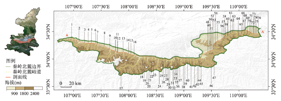
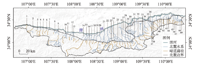
图1 秦岭北麓主要峪道空间分布格局注:1晁峪;2.清姜峪;3.茵香峪;4.清水峪;5.马尾峪;6.磻溪峪;7.伐鱼峪;8.同峪;9.斜峪;10.赤峪;11.大黑峪;12.小黑峪;13.西汤峪;14.泥峪;15.竹峪;16.西骆峪;17.黑峪;18.团标峪;19.就峪;20.田峪;21.赤峪;22.耿峪;23.甘峪;24.涝峪;25.谭峪;26.曲峪;27.黄柏峪;28.太平峪;29.紫阁峪;30.高冠峪;31.祥峪;32.沣峪;33.黄峪;34.白石峪;35.子午峪;36.抱龙峪;37.天子峪;38.石砭峪;39.太乙峪;40.小峪;41.大峪;42.库峪;43.东汤峪;44.大洋峪;45.岱峪;46.辋峪;47.蓝峪;48.大峪;49.赛峪;50.福朝峪;51.石沟峪;52.流峪;53.道沟峪;54.清峪;55.大奓峪;56.西涧峪;57.东涧峪;58.桥峪;59.马峪;60.石堤峪;61.小夫峪;62.沟峪;63.方山峪;64.大夫峪;65.仙峪;66.华山峪;67.黄甫峪;68.杜峪;69.蒲峪;70.翎峪;71.潼峪;72.嵩岔峪;73.麻峪;74.太峪;75.善车峪;76.桐峪 Fig. 1 Distribution of the main valley roads at the northern foothills of the Qinling Mountains |
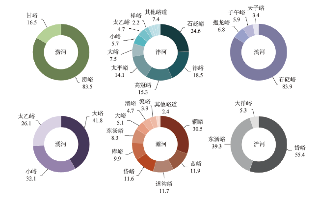
图9 秦岭北麓水系与峪道承袭关系注:1.晁峪河;2.清姜河;3.茵香河;4.清水河;5.马尾河;6.磻溪河;7.伐鱼河;8.同峪河;9.石头河;10.霸王河;11.沙河;12.汤峪河;13.泥峪河;14.西骆峪河;15.黑河;16.田峪河;17.赤峪河;18.大耿峪河;19.甘峪河;20.涝河;21.新河;22.沣河;23.金沙河;24.潏河;25.滈河;26.大峪河;27.灞河;28.库峪河;29.浐河;30.岱峪河;31.辋峪河;32.蓝桥河;33.清峪河;34.沋河;35.赤水河;36.遇仙河;37.马峪河;38.石堤河;39.罗纹河;40.沟峪河;41.方山河;42.罗敷河;43.柳叶河;44.长涧河;45.蒲峪河;46.翎峪河;47.晋沟河;48.西峪河;49.桐峪河。 Fig. 9 The relationship between the river system and the valley roads at the northern entrances of the Qinling Mountains |
感谢两位匿名专家对该文结构框架、数据处理及共享数据等提出的宝贵意见,感谢Google Earth公开数据、NASA卫星数据、自然资源部标准地图服务中心网站(
| [1] |
[郭安林, 张国伟, 董云鹏, 等. 秦岭: 地球多圈层相互作用的热点. 西北大学学报(自然科学版), 2021, 51(6): 922-934.]
|
| [2] |
[李君轶, 傅伯杰, 孙九林, 等. 新时期秦岭生态文明建设: 存在问题与发展路径. 自然资源学报, 2021, 36(10): 2449-2463.]
|
| [3] |
[张国伟. 试论秦岭造山带岩石圈构造演化基本特征. 西北大学学报(自然科学版), 1991, 21(2): 77-87.]
|
| [4] |
[张俊华, 朱连奇, 李国栋, 等. 中国南北过渡带土壤碳氮空间特征及暖温带与亚热带界限. 地理学报, 2021, 76(9): 2269-2282.]
|
| [5] |
[李双双, 芦佳玉, 延军平, 等. 1970—2015年秦岭南北气温时空变化及其气候分界意义. 地理学报, 2018, 73(1): 13-24.]
|
| [6] |
[陈怡平. 大秦岭生态文明建设的意义与对策. 地球环境学报, 2019, 10(1): 1-11.]
|
| [7] |
[李大伟, 段克勤, 石培宏, 等. 秦岭中部山地降水的垂直变化研究. 地理学报, 2022, 77(7): 1762-1774.]
|
| [8] |
[马新萍. 秦岭林线及其对气候变化的响应[D]. 西安: 西北大学, 2015.]
|
| [9] |
[马国杰. 问道秦岭三百峪:旅游心理视域下的秦岭调研. 西安: 陕西师范大学出版总社, 2023.]
|
| [10] |
[张宏飞, 张本仁, 骆庭川. 北秦岭新元古代花岗岩类成因与构造环境的地球化学研究. 地球科学, 1993, 18(2): 194-202, 248.]
|
| [11] |
[中屠炳明, 宋方敏, 曹忠权, 等. 秦岭北麓晚第四纪断层陡坎的初步研究. 地震地质, 1991, 13(1): 15-25.]
|
| [12] |
[孟庆任. 秦岭的由来. 中国科学: 地球科学, 2017, 47(4): 412-420.]
|
| [13] |
[查方勇, 郭威, 张健, 等. 秦岭终南山世界地质公园地质遗迹资源及价值评价. 干旱区资源与环境, 2016, 30(2): 182-187.]
|
| [14] |
[刘胤汉. 秦岭水文地理. 西安: 陕西人民出版社, 1983.]
|
| [15] |
[周灵国, 谢伟. 秦岭七十二峪. 西安: 陕西科学技术出版社, 2018.]
|
| [16] |
[杨松茂, 任燕. 秦岭北麓“峪口型地域”深层次开发研究. 西北大学学报(哲学社会科学版), 2009, 39(5): 55-59.]
|
| [17] |
[张建. 秦岭北麓水系现状调查研究: 以辋川河水生态治理为例[D]. 西安: 西安理工大学, 2019.]
|
| [18] |
[王国今, 张进明, 岳邦瑞. 关中城市群生态复兴中的秦岭北麓河流管控体系探索. 城市建筑, 2018, 33: 11-15.]
|
| [19] |
[郭晓童. 生态保护视角下的秦岭峪道规划设计研究: 以西安段高冠峪为例[D]. 北京: 中国林业科学研究院, 2021.]
|
| [20] |
[龙小霞. 陕西省田峪河流域旅游景观生态规划与设计研究[D]. 西安: 陕西师范大学, 2007.]
|
| [21] |
[薛妍. 秦岭北麓峪道型风景区空间景观规划设计研究: 以金龙峡隐逸文化主题风景区为例[D]. 西安: 西安建筑科技大学, 2014.]
|
| [22] |
[张聪. 基于格局与过程关系的秦岭北麓涝峪段空间格局优化方法研究[D]. 西安: 西安建筑科技大学, 2018.]
|
| [23] |
[滕欣. 秦岭北麓峪口型地域保护利用格局研究: 以太平峪为例[D]. 西安: 西安建筑科技大学, 2016.]
|
| [24] |
[蒙利, 赵燕伶, 郝旋捷. 遥感技术在秦岭北麓国土资源卫星遥感监测中的应用. 陕西地质, 2022, 40(1): 88-91.]
|
| [25] |
[王国今. 秦岭北麓骆峪河景观演变动力机制研究[D]. 西安: 西安建筑科技大学, 2019.]
|
| [26] |
[张伯声. 在块断构造的基础上說明秦岭两侧河流的发育. 地质学报, 1964, 44(4): 405-417.]
|
| [27] |
[马志正, 魏西昌, 卫华, 等. 牛心峪河流域地貌研究. 山西师范大学学报(自然科学版), 2004, 18(2): 93-97.]
|
| [28] |
Shaanxi Provincial Development and Reform Commission, Shaanxi Provincial Department of Finance Research on Comprehensive Management of Qinling Ecosystem. Beijing: China Development Press, 2018.
[陕西省发展和改革委员会, 陕西省财政厅. 秦岭生态系统综合管理研究. 北京: 中国发展出版社, 2018.]
|
| [29] |
People's Daily Online. Why is Qinling the 'Central Water Tower'? 2023. http://env.people.com.cn/n1/2023/0613/c1010-40011962.html.
[人民网. 秦岭为什么是“中央水塔”? 2023. http://env.people.com.cn/n1/2023/0613/c1010-40011962.html.]
|
| [30] |
[毛水龙. 秦岭北麓峪沟口. 西安: 三秦出版社, 2011.]
|
| [31] |
Forestry Bureau of Shaanxi Province. Investigation report of ecological construction in the northern foot of Qinling Mountains 2021. https://lyj.shaanxi.gov.cn/zfxxgk/zcjd/202112/t20211213_2203825.html.
[陕西省林业局. 秦岭北麓生态建设调查报告2021. https://lyj.shaanxi.gov.cn/zfxxgk/zcjd/202112/t20211213_2203825.html.]
|
/
| 〈 |
|
〉 |