
长江下游崩岸段动力分区特征与地貌适应机制
|
陈锦锋(1998-), 男, 福建省宁德人, 硕士生, 主要从事河口海岸工程地貌方面研究。E-mail: 51213904054@stu.ecnu.edu.cn |
收稿日期: 2024-02-28
修回日期: 2024-08-24
网络出版日期: 2024-09-27
基金资助
国家自然科学基金项目(42271009)
中国地质调查局项目(DD20221728)
Characteristics of hydrodynamic zone and microgeomorphic adaptation mechanism of the bank failure section in the lower reaches of the Yangtze River
Received date: 2024-02-28
Revised date: 2024-08-24
Online published: 2024-09-27
Supported by
National Natural Science Foundation of China(42271009)
China Geological Survey(DD20221728)
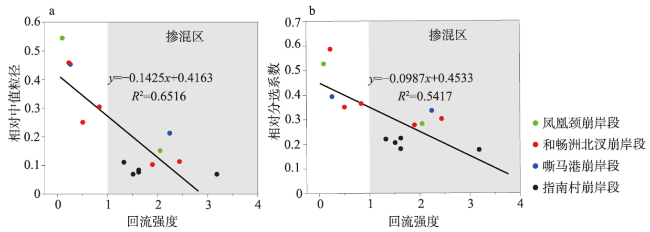
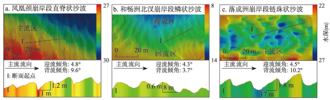
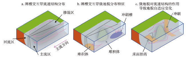
近年来长江下游潮区界上移、涉水工程建设增多,河道崩岸灾害强度增大。前人通过现场观测、物理模型、数值模拟发现崩岸段存在强烈竖轴回流,但未探讨滩槽交互带水动力分区特征及地貌的微观适应机制。本文基于频繁窝崩岸段多普勒声学流速剖面仪(ADCP)、多波束测深系统获得的高分辨率动力、地貌同步观测数据,结合以往高分辨水下地形资料,研究发现:滩槽交互带流速、流向具有显著分区特性,根据纵向流速u及其与横向流速v的比值|u/v|,即回流强度α,自槽向岸分为主流区(α<1,u>0)、掺混区( ≥1)和贴岸回流区(α<1,u≤0);主流区发育大中型沙波、冲刷槽、冲刷坑,掺混区发育堆积体、小型沙波,回流区发育有窝脊、小型沙波;主流区主流顶冲、回流区回流侧蚀是冲刷地貌发育、崩岸拓展的主要动力,掺混区近主流区一侧的高流速梯度产生冲刷地貌、其余部分低流速使泥沙落淤形成堆积体。本文可为崩岸灾害整治和近岸工程设计监测提供重要参考。

陈锦锋 , 滕立志 , 刘瑞清 , 程和琴 , 任仲达 , 金阳 , 张鸿 , 贾正阳 , 周权平 , 邢海斌 . 长江下游崩岸段动力分区特征与地貌适应机制[J]. 地理学报, 2024 , 79(9) : 2246 -2260 . DOI: 10.11821/dlxb202409006
In recent years, the tidal limit of the lower reaches of the Yangtze River has shifted upward, the construction of water-related projects has increased, and the intensity of river bank failure disasters has been on the rise. Previous researchers have found the existence of strong vertical-axial backflow in the bank failure section through field surveys, physical modeling, and numerical simulation, and that there is a strong vertical-axial backflow in the bank failure section; however, the hydrodynamic zone characteristics of the bank-channel interactive zone and the microgeomorphic adaptation mechanism have not been explored. Based on the Doppler acoustic current profiler (ADCP) in the frequent bank failure sections, multibeam system, combined with previous high-resolution underwater topographic data, it is found that the flow velocity and flow direction in the interactive zone of the bank-channel have significant zone characteristics, and according to the backflow strength , i.e., the longitudinal flow velocity u and its ratio to the transverse flow velocity v, |u/v|, the zone from the channel to the bank is identified into the main stream zone (α<1, u>0), the mixing zone (α≥1), and the near-bank backflow zone (α<1, u<0). The mainstream zone develops large and medium-sized dunes, scour grooves, and scour pits, the mixing zone develops accumulators and small dunes, and the backflow zone develops spines and small dunes; the main stream direct flushing in the mainstream zone and the backflow lateral erosion in the backflow zone are the main driving forces for the development of scouring microgeomorphic type and the development of bank failures, and the high flow velocity gradient in the mixing zone near the main stream zone generates scouring geomorphology, and the remaining part of mixing zone remains a low flow-velocity to make the sediment fall and silt to form the accumulation body. The findings can provide important references for the disaster remediation and near-shore engineering design and monitoring.
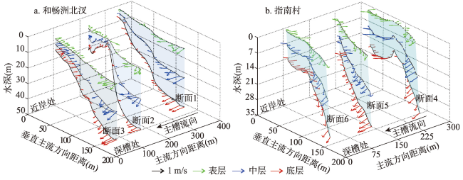
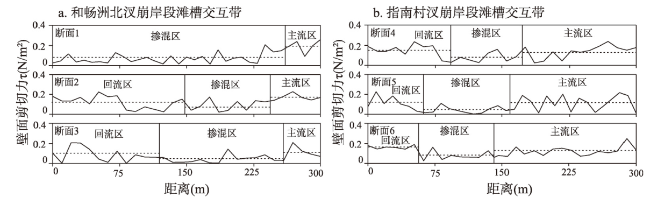
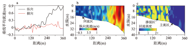
图2 长江镇江河段和畅洲北汊与指南村崩岸段滩槽交互带流速结构Fig. 2 Flow structure of the bank-channel interactive zone between the north branch of Hechang Island and Zhinancun in the Zhenjiang section of Yangtze River |
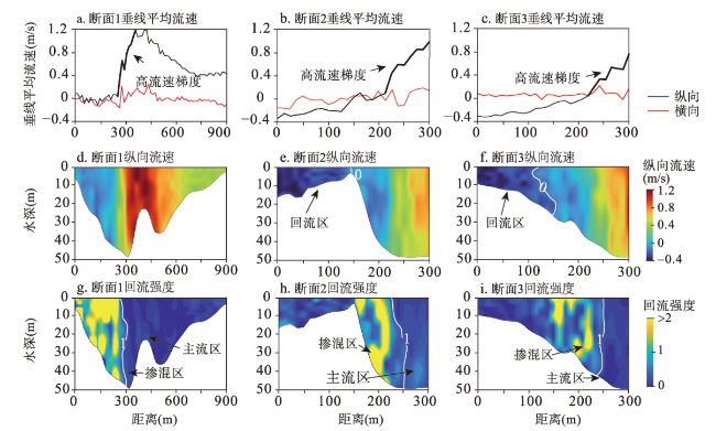
图3 长江和畅洲北汊崩岸段滩槽交互带垂线平均流速、纵向流速和回流强度断面Fig. 3 Mean vertical line flow velocity, longitudinal flow velocity, and backflow strength in the bank-channel interactive zone of the north branch of Hechang Island bank failure section of Yangtze River |
表1 崩岸段河床表层沉积物粒度参数Tab. 1 Grain size parameters of surface sediments in the riverbed of the bank failure sections |
| 采样点 | 序号 | 沉积物体积(%) | 中值粒径 (μm) | (cm/s) | α | 位置 | 主槽中值粒径(μm) | |||
|---|---|---|---|---|---|---|---|---|---|---|
| 沉积物粒度参数(μm) | ||||||||||
| ≤ 4 | 4~63 | > 63 | ||||||||
| 凤凰颈崩岸段 | 1 | 16.3 | 39.4 | 44.3 | 48.5 | -28.6 | 0.1 | 回流区 | 89 | |
| 2 | 24.3 | 50.9 | 24.8 | 13.5 | 4.3 | 2.1 | 掺混区 | |||
| 和畅洲北汊崩岸段 | 3 | 16.5 | 42.2 | 41.3 | 40.8 | -18.7 | 0.5 | 回流区 | 163 | |
| 4 | 14.9 | 32.2 | 52.9 | 74.7 | -37.8 | 0.2 | 回流区 | |||
| 5 | 15.7 | 38.8 | 45.5 | 49.7 | -25.2 | 0.8 | 回流区 | |||
| 6 | 22.4 | 50.7 | 26.9 | 18.5 | 4.7 | 2.4 | 掺混区 | |||
| 7 | 23.1 | 50.5 | 26.4 | 16.8 | -10.5 | 1.9 | 掺混区 | |||
| 嘶马港崩岸段 | 8 | 6.5 | 21.1 | 72.5 | 113.2 | -23.3 | 0.3 | 回流区 | 250 | |
| 9 | 15.4 | 37.4 | 47.2 | 53.1 | -2.3 | 2.2 | 掺混区 | |||
| 指南村崩岸段 | 10 | 21.9 | 59.5 | 18.6 | 18.0 | -6.9 | 1.3 | 掺混区 | 162 | |
| 11 | 24.5 | 58.6 | 16.9 | 13.6 | 8.3 | 1.6 | 掺混区 | |||
| 12 | 25.0 | 63.5 | 11.5 | 12.4 | 6.7 | 1.6 | 掺混区 | |||
| 13 | 27.2 | 62.7 | 10.2 | 11.2 | -3.3 | 3.2 | 掺混区 | |||
| 14 | 26.5 | 61.2 | 12.3 | 11.2 | -3.9 | 1.5 | 掺混区 | |||
注:主槽表层沉积物中值粒径来自文献[33]。 |
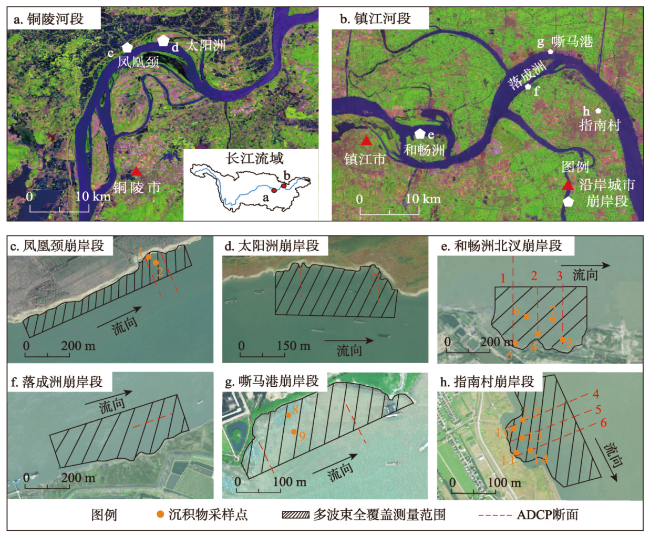
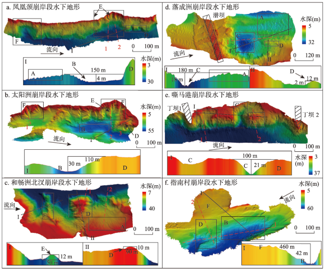
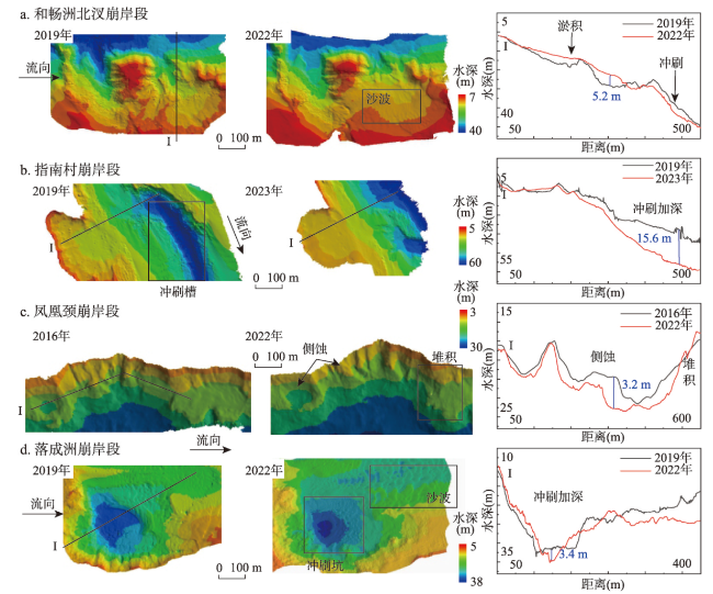
图7 长江下游典型崩岸段滩槽交互带水下地形及微地貌特征Fig. 7 Characteristics of underwater topography and microgeomorphic type in the typical bank failure sections of the bank-channel interactive zones in the lower reaches of the Yangtze River |
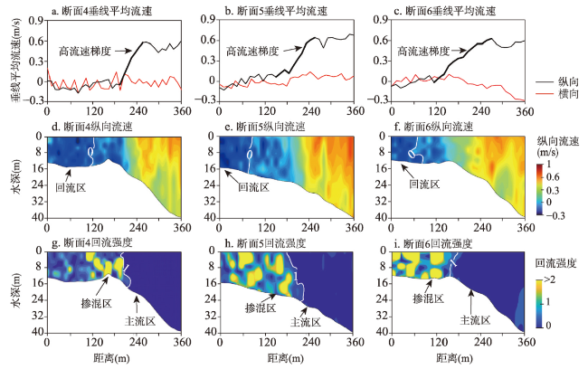
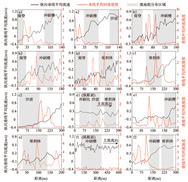
图9 长江下游典型崩岸段滩槽交互带垂线平均纵向流速、垂线平均回流强度断面及微地貌分布范围注:流速断面位置及序号见图7,断面起点为上游侧(或近岸侧)。 Fig. 9 Mean vertical line flow velocity , mean vertical line backflow intensity and microgeomorphic distribution ranges in the typical bank failure sections of the bank-channel interactive zone in the lower reaches of the Yangtze River |
| [1] |
|
| [2] |
|
| [3] |
|
| [4] |
|
| [5] |
|
| [6] |
|
| [7] |
|
| [8] |
[余文畴. 长江中下游河道崩岸机理中的河床边界条件. 长江科学院院报, 2008, 25(1): 8-11.]
|
| [9] |
|
| [10] |
[王媛, 李冬田. 长江中下游崩岸分布规律及窝崩的平面旋涡形成机制. 岩土力学, 2008, (4): 919-924.]
|
| [11] |
[冷魁. 长江下游窝崩形成条件及防护措施初步研究. 水科学进展, 1993, 4(4): 281-287.]
|
| [12] |
[张家豪, 程和琴, 陈钢, 等. 近期长江下游典型河漫滩边坡稳定性分析. 泥沙研究, 2019, 44(3): 39-46.]
|
| [13] |
[张幸农, 牛晨曦, 假冬冬, 等. 流滑型窝崩水流结构特征及其变化规律. 水科学进展, 2020, 31(1): 112-119.]
|
| [14] |
[余文畴. 长江中下游河道“口袋型”崩窝形成机理初步研究. 人民长江, 2007, 38(6): 40-42.]
|
| [15] |
[假冬冬, 陈长英, 张幸农, 等. 典型窝崩三维数值模拟. 水科学进展, 2020, 31(3): 385-393.]
|
| [16] |
[孙启航, 夏军强, 邓珊珊, 等. 窝崩区水流结构的概化水槽试验研究. 水科学进展, 2023, 34(1): 144-156.]
|
| [17] |
|
| [18] |
|
| [19] |
[应强, 张幸农, 罗龙洪, 等. 基于父子型窝塘地形变化探讨窝崩机理. 水利水运工程学报, 2020(3): 37-42.]
|
| [20] |
|
| [21] |
[石盛玉, 程和琴, 郑树伟, 等. 三峡截流以来长江洪季潮区界变动河段冲刷地貌. 海洋学报, 2017, 39(3): 85-95.]
|
| [22] |
|
| [23] |
[刘亚, 李义天, 卢金友. 鹅头分汊河型河道演变时空差异研究. 应用基础与工程科学学报, 2015, 23(4): 705-714.]
|
| [24] |
|
| [25] |
|
| [26] |
[杨云平, 张夏博, 郑金海, 等. 长江下游落成洲河段洲滩联动关系与航道浅滩碍航机制. 水科学进展, 2023, 34(2): 250-264.]
|
| [27] |
[刘青泉. 盲肠河段口门掺混区的泥沙扩散. 泥沙研究, 1995(2): 11-21.]
|
| [28] |
|
| [29] |
[丁君松. 弯道环流横向输沙. 武汉水利电力学院学报, 1965(1): 59-80.]
|
| [30] |
[谢亚光, 余明辉, 胡鹏, 等. 弯道凹岸不同部位崩塌体对近岸水流结构影响的试验研究. 水科学进展, 2019, 30(5): 727-737.]
|
| [31] |
[李成光, 槐文信, 曾玉红, 等. 强弯河道水流结构及离散特性研究. 华中科技大学学报(自然科学版), 2014, 42(2): 64-67.]
|
| [32] |
[向媛, 余明辉, 魏红艳, 等. 急弯河道壁面切应力及计算方法研究. 工程科学与技术, 2017, 49(2): 45-53.]
|
| [33] |
[陈钢, 程和琴. 长江下游河道河床阻力分布特征及影响因素分析. 长江科学院院报, 2019, 36(8): 10-16.]
|
| [34] |
[吉祖稳, 胡春宏. 复式河道滩槽交互区水沙运动机理. 水科学进展, 2017, 28(3): 321-328.]
|
| [35] |
[吉祖稳, 胡春宏, 吉明栋. 复式河道滩槽泥沙粒径分布特性. 应用基础与工程科学学报, 2016, 24(4): 649-660.]
|
| [36] |
|
| [37] |
|
| [38] |
|
| [39] |
[程和琴, 宋波, 薛元忠, 等. 长江口粗粉砂和极细砂输移特性研究: 幕式再悬浮和底形运动. 泥沙研究, 2000(1): 20-27.]
|
| [40] |
Yangtze River Basin Planning Office. Selected Experience of Bank Protection Engineering in the Middle and Lower Reaches of the Yangtze River. Beijing: Science Press, 1978.
[长江流域规划办公室. 长江中下游护岸工程经验选编. 北京: 科学出版社, 1978.]
|
/
| 〈 |
|
〉 |