
乡村聚落与耕地共生理论模型及案例区情景模拟
|
马利邦(1984-), 男, 甘肃酒泉人, 教授, 博士生导师, 研究方向为城乡发展与空间规划、乡村转型与重构。E-mail: malb0613@nwnu.edu.cn |
收稿日期: 2023-04-19
修回日期: 2024-04-30
网络出版日期: 2024-05-31
基金资助
国家自然科学基金项目(42271222)
国家自然科学基金项目(42261033)
Theoretical model of symbiosis between rural settlements and cultivated land and scenarios simulation in case area
Received date: 2023-04-19
Revised date: 2024-04-30
Online published: 2024-05-31
Supported by
National Natural Science Foundation of China(42271222)
National Natural Science Foundation of China(42261033)
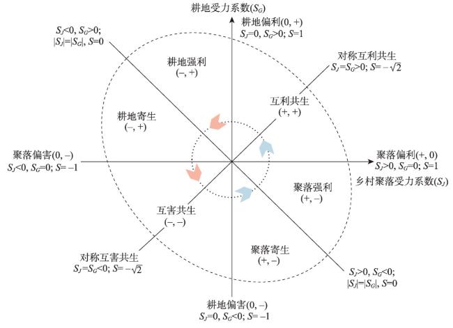
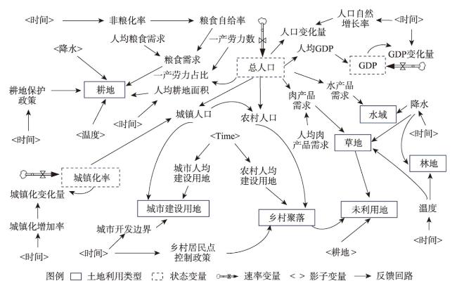
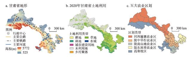
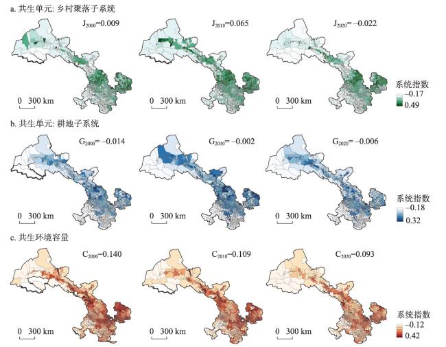
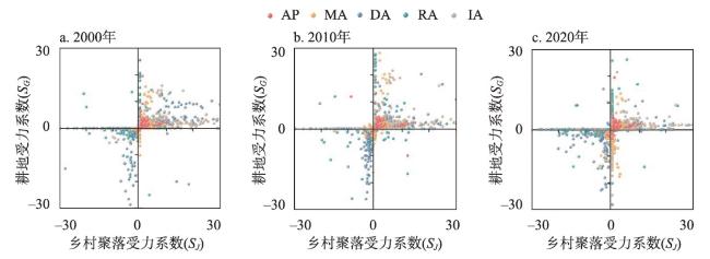
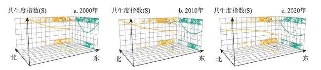
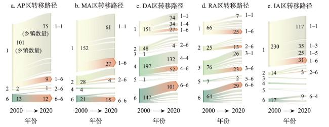
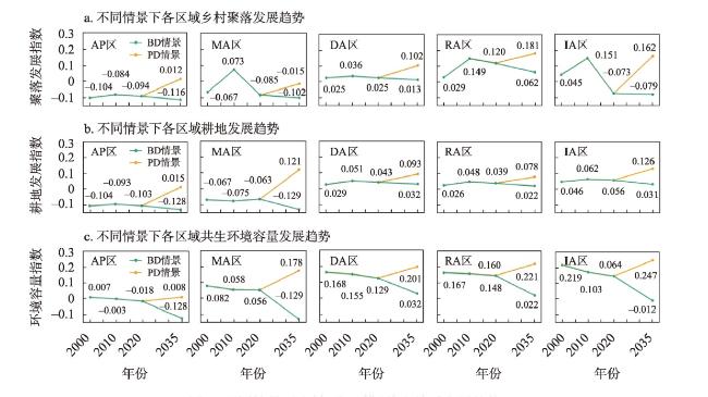
乡村聚落与耕地作为描述乡村发展的重要子系统,两者互利共生对于乡村可持续发展至关重要。在甘肃省环境异质性背景下,以1384个乡(镇)为研究单元,引入共生理论构建乡村聚落与耕地共生框架,构建乡村聚落、耕地、共生环境评价指标体系,借助Lotka-Volterra模型识别其共生模式。新一轮国土空间规划背景下,借助SD-FLUS耦合模型对比分析2035年惯性发展情景(BD)和规划发展情景(PD)下共生模式演变趋势。研究发现:① 2000—2020年甘肃省乡村聚落、耕地发展水平呈先增后减趋势,共生环境容量呈持续下降趋势;五大农业区划3个指标差异显著,河西灌溉农业区(IA)具有明显发展优势。② 2000—2020年甘肃省乡村聚落与耕地共生模式整体呈互利共生向互害共生转变,互利共生占比由59.80%下降至38.97%;区域间主导模式差异显著,高寒牧区(AP)、陇南山地农业区(MA)、IA以互利共生为主,陇中旱作农业区(DA)、陇东雨养农业区(RA)分别以聚落偏害、耕地偏利为主;2000—2020年各区域主导模式均趋于多元化且呈现出由互利共生向互害共生转移的发展共性。③ 不同情景下共生模式差异显著,BD情景下五大区域延续历史粗放发展模式,互利共生模式占比均持续减少,而PD情景下因共生单元、环境容量水平的提升,共生模式向互利共生进化。

马利邦 , 张文博 , 王祥 , 陈贤斐 , 白静 . 乡村聚落与耕地共生理论模型及案例区情景模拟[J]. 地理学报, 2024 , 79(5) : 1265 -1285 . DOI: 10.11821/dlxb202405011
As an important subsystem describing rural development, the mutually beneficial symbiosis of rural settlements and cultivated land is crucial for sustainable rural development. Under the heterogeneous physical environment of Gansu province, 1384 townships were taken as the research units, and the symbiosis theory was introduced to construct a framework for the symbiosis between rural settlements and cultivated land. We construct a system of indicators for evaluating rural settlements, cultivated land, symbiosis environments, and identify their symbiosis patterns with the help of the Lotka-Volterra model. In the context of the new round of territorial spatial planning, the SD-FLUS coupled model is used to compare and analyze the evolutionary trends of symbiosis patterns under the baseline development scenario (BD) and the planning development scenario (PD) in 2035. The study found that: (1) The development level of rural settlements and cultivated land in Gansu shows a trend of first increasing and then decreasing, and the symbiosis environmental capacity shows a continuous decreasing trend. Three indicators of the five agricultural zones have significant differences. The irrigated agriculture area of the Hexi Region (IA) has an obvious advantage in the regional development. (2) The overall pattern of symbiosis between rural settlements and cultivated land in the province showed a shift from mutually beneficial symbiosis to mutually detrimental symbiosis, with the proportion of mutually beneficial symbiosis decreasing from 59.80% to 38.97%. There were significant differences in dominant patterns between regions. Alpine pastoral area (AP), mountainous agricultural area (MA), and IA are dominated by mutually beneficial symbiosis, while dry agricultural area (DA) and rain-fed agricultural area (RA) are dominated by rural settlements-bias and cultivated land-bias. During the 21-year period, the dominant pattrens of each region tended to be diversified and showed a commonality in the transformation from mutually beneficial symbiosis to mutually detrimental symbiosis. (3) The symbiosis relationship between rural settlements and cultivated land varies significantly under different scenarios. In the BD scenario, the five regions continue the historical rough development pattern, and the proportion of mutually beneficial symbiosis continues to decrease. In the PD scenario, the symbiosis pattern evolves to mutually beneficial symbiosis due to the improvement of symbiosis unit and environmental development level.
表1 乡村“聚—耕”共生系统评价指标体系Tab. 1 Indicators for evaluating the symbiosis system of "rural settlements-cultivated land" |
| 共生系统 | 准则层 | 指标层 | 单位 | 符号 | 权重 |
|---|---|---|---|---|---|
| 乡村聚落子系统 | 产出效益 | 农村居民人均收入 | 元/人 | + | 0.115 |
| 单位面积农业生产值 | 元/m2 | + | 0.175 | ||
| 空间集约度 | 人均农村居民点用地面积 | m2/人 | - | 0.449 | |
| 平均斑块分维数 | - | - | 0.091 | ||
| 斑块集聚指数 | - | + | 0.170 | ||
| 耕地子系统 | 耕地质量 | 非粮化程度 | % | - | 0.107 |
| 从事第一产业劳动力占比 | % | + | 0.101 | ||
| 有效灌溉面积占比 | % | + | 0.222 | ||
| 产出能力 | 粮食自给率 | % | + | 0.112 | |
| 每百人拥有农业合作社数量 | 个 | + | 0.063 | ||
| 粮食单产 | kg/hm2 | + | 0.104 | ||
| 空间规模化 | 人均耕地面积 | m2/人 | + | 0.185 | |
| 平均斑块分维数 | - | - | 0.054 | ||
| 斑块集聚指数 | - | + | 0.052 | ||
| 共生环境容量 | 物质环境 | DEM | m | - | 0.112 |
| 坡度 | ° | - | 0.071 | ||
| 土壤类型 | - | - | 0.118 | ||
| 气温 | ℃ | + | 0.090 | ||
| 降水 | mm | + | 0.052 | ||
| 耕地生产潜力 | kg/hm2 | + | 0.139 | ||
| 聚落距耕地距离 | m | - | 0.050 | ||
| 国土空间 | 生产用地占比 | % | + | 0.217 | |
| 生活用地占比 | % | - | 0.048 | ||
| 生态用地占比 | % | + | 0.103 |
表2 情景模拟参数设置Tab. 2 Scenario simulation parameter setting |
| 情景参数 | 人口增长率(%) | 城镇化率(%) | GDP增长率(%) | 年均降雨量变化(mm/a) | 年均气温变化(℃/a) | 耕地保有量(104 km2) | 生态保护面积(104 km2) | 城市开发边界控制倍数 |
|---|---|---|---|---|---|---|---|---|
| BD | 0.50 | 1.72 | 5.00 | 0.10 | 0.02 | 无 | 无 | 无 |
| PD | 0.80 | 1.04 | 7.50 | 0.12 | 0.03 | 5.10 | 12.50 | 1.30 |
表3 数据来源、属性及用途Tab. 3 Sources, attributes and uses of data |
| 类别 | 数据名称 | 数据类型/分辨率 | 数据用途 | 数据来源 |
|---|---|---|---|---|
| 土地利用数据 | 甘肃省土地利用 | 栅格/30 m | SD、FLUS模型的输入和验证 | 中国科学院资源环境科学数据中心 |
| 社会经济数据 | 人口密度 | 栅格/1 km | FLUS模型输入 | 中国科学院资源环境科学数据中心 |
| GDP | 栅格/1 km | FLUS模型输入 | 中国科学院资源环境科学数据中心 | |
| 人口统计数据、农业收入、非粮作物播种面积、第一产业人数、灌溉面积、水产品需求等 | 统计数据 | 共生单元评价、SD模型构建 | 甘肃省发展年鉴(乡镇篇);各县(区)统计年鉴;中国县域统计年鉴(乡镇) | |
| 自然环境数据 | 年均降水 | 栅格/30 m | FLUS模型输入 | 国家地球系统科学数据中心 |
| 年均气温 | 栅格/30 m | FLUS模型输入 | 全国地理信息资源目录服务系统 | |
| 未来气候 | 栅格/1 km | SD模型构建 | 国家地球系统科学数据黄土高原分中心 | |
| DEM | 栅格/30 m | 共生环境评价、FLUS模型输入 | 地理空间数据云 | |
| 坡度 | 栅格/30 m | 共生环境评价、FLUS模型输入 | 由DEM计算获得 | |
| 土壤类型 | 栅格/30 m | 共生环境评价、FLUS模型输入 | 中国科学院资源环境科学数据中心 | |
| 耕地生产潜力 | 栅格/30 m | 共生环境评价 | 中国科学院资源环境科学数据中心 | |
| 交通路网数据 | 铁路、省道、县道、乡道、乡村聚落距耕地距离 | 矢量 | 共生环境评价、FLUS模型输入 | 国家基础地理信息中心 |
| 政策规划数据 | 甘肃省国土空间规划(2021—2035年) | 文本数据库 | 情景设置 | 甘肃省自然资源厅 |
注:中国科学院资源环境科学数据中心(http://www.resdc.cn/);地理空间数据云(https://www.gscloud.cn/);中国气象网(https://www.cma.gov.cn/);全国地理信息资源目录服务系统(http://www.webmap.cn/);国家基础地理信息中心(http://ngcc.sbsm.gov.cn/);国家地球系统科学数据中心(http://www.geodata.cn/),其黄土高原分中心(http://www.loess.geodata.cn/)发布了2021—2100年中国1 km的逐月降水量、平均气温数据。 |
表4 2000—2020年甘肃省共生单元、环境容量分指标变化Tab. 4 Changes in symbiosis units, environmental capacity sub-indicators in Gansu province, 2000-2020 |
 年份 年份 | 区域 | 乡村聚落子系统 | 耕地子系统 | 共生环境容量 | ||||
|---|---|---|---|---|---|---|---|---|
| 产出效益 | 聚落集约度 | 耕地质量 | 产出能力 | 规模化指数 | 物质环境 | 国土空间 | ||
| 2000 | AP | 0.015 | -0.320 | -0.003 | 0.015 | 0.014 | -0.150 | 0.085 |
| MA | 0.065 | -0.160 | -0.006 | 0.035 | 0.023 | -0.120 | 0.099 | |
| DA | 0.125 | -0.100 | -0.005 | 0.095 | 0.024 | -0.050 | 0.199 | |
| RA | 0.207 | -0.065 | -0.015 | 0.094 | 0.040 | -0.077 | 0.213 | |
| IA | 0.333 | -0.103 | -0.040 | 0.166 | 0.020 | -0.011 | 0.287 | |
| 甘肃省 | 0.149 | -0.150 | -0.014 | 0.081 | 0.024 | -0.082 | 0.177 | |
| 2010 | AP | 0.011 | -0.350 | -0.003 | 0.010 | 0.011 | -0.170 | 0.065 |
| MA | 0.075 | -0.180 | -0.006 | 0.032 | 0.022 | -0.130 | 0.089 | |
| DA | 0.131 | -0.095 | -0.007 | 0.104 | 0.021 | -0.051 | 0.185 | |
| RA | 0.206 | -0.058 | -0.001 | 0.103 | 0.036 | -0.097 | 0.201 | |
| IA | 0.334 | -0.097 | -0.029 | 0.171 | 0.016 | -0.014 | 0.271 | |
| 甘肃省 | 0.151 | -0.156 | -0.009 | 0.084 | 0.021 | -0.092 | 0.162 | |
| 2020 | AP | 0.009 | -0.370 | -0.003 | 0.011 | 0.012 | -0.210 | 0.055 |
| MA | 0.055 | -0.200 | -0.006 | 0.033 | 0.023 | -0.144 | 0.079 | |
| DA | 0.128 | -0.103 | -0.006 | 0.124 | 0.020 | -0.058 | 0.159 | |
| RA | 0.195 | -0.075 | -0.002 | 0.123 | 0.032 | -0.077 | 0.141 | |
| IA | 0.332 | -0.106 | -0.043 | 0.173 | 0.011 | -0.019 | 0.239 | |
| 甘肃省 | 0.144 | -0.171 | -0.012 | 0.093 | 0.020 | -0.102 | 0.135 | |
| [1] |
[刘彦随, 陈百明. 中国可持续发展问题与土地利用/覆被变化研究. 地理研究, 2002, 21(3): 324-330.]
|
| [2] |
|
| [3] |
|
| [4] |
[杨宇, 李小云, 董雯, 等. 中国人地关系综合评价的理论模型与实证. 地理学报, 2019, 74(6): 1063-1078.]
|
| [5] |
[贾铠阳, 乔伟峰, 胡晓亮, 等. 江苏省典型县域村镇建设格局演化模式. 地理学报, 2022, 77(12): 2954-2971.]
|
| [6] |
|
| [7] |
|
| [8] |
[李婷婷, 龙花楼, 王艳飞, 等. 黄淮海平原农区宅基地扩展时空特征及整治潜力分析: 以禹城市5个村庄为例. 自然资源学报, 2020, 35(9): 2241-2253.]
|
| [9] |
[刘彦随. 科学推进中国农村土地整治战略. 中国土地科学, 2011, 25(4): 3-8.]
|
| [10] |
[刘彦随. 中国新时代城乡融合与乡村振兴. 地理学报, 2018, 73(4): 637-650.]
|
| [11] |
[戈大专, 陆玉麒, 孙攀. 论乡村空间治理与乡村振兴战略. 地理学报, 2022, 77(4): 777-794.]
|
| [12] |
|
| [13] |
[许彩彩, 吕春娟, 陈卓, 等. 省域视角下耕地自然质量空间格局与影响因素. 中国农业资源与区划, 2022, 43(3): 253-264.]
|
| [14] |
[张潇, 谷人旭. 土地利用冲突的时空格局刻画与多情景模拟研究: 以长江三角洲城市群为例. 地理研究, 2022, 41(5): 1311-1326.]
|
| [15] |
[冯雨柯, 翟石艳, 姜昕彤, 等. 中原城市群“三生”空间模拟及生态效应评估: 基于未来土地利用模拟模型和共享社会经济路径情景. 生态学报, 2023, 43(20): 8292-8308.]
|
| [16] |
[洪黎民. 共生概念发展的历史、现状及展望. 中国微生态学杂志, 1996, 8(4): 50-54.]
|
| [17] |
|
| [18] |
|
| [19] |
|
| [20] |
|
| [21] |
[吴飞驰. 关于共生理念的思考. 哲学动态, 2000(6): 22-25.]
|
| [22] |
[胡守钧. 社会共生论. 2版. 上海: 复旦大学出版社, 2012.]
|
| [23] |
|
| [24] |
[刘玉邦, 眭海霞. 绿色发展视域下我国城乡生态融合共生研究. 农村经济, 2020(8): 19-27.]
|
| [25] |
[孙博, 王广成. 矿区生态产业共生系统的稳定性. 生态学报, 2012, 32(10): 3296-3302.]
|
| [26] |
|
| [27] |
|
| [28] |
[李红波, 张小林, 吴启焰, 等. 发达地区乡村聚落空间重构的特征与机理研究: 以苏南为例. 自然资源学报, 2015, 30(4): 591-603.]
|
| [29] |
|
| [30] |
[丁焕峰, 张蕊, 谭一帆. 创新型农产品产销体系: 促进小农户与现代农业发展有机衔接. 农业经济问题, 2024(2): 121-134.]
|
| [31] |
[王全喜, 宋戈, 隋虹均. 耕地“非农化”的时空格局演变及其驱动因素研究: 基于影响分析与组态分析的双重视角. 中国土地科学, 2023, 37(5): 113-124.]
|
| [32] |
|
| [33] |
|
| [34] |
FAO. The state of food and agriculture 2016: Climate change, agriculture and food security. United Nations, 2016. DOI: 10.18356/32576202-en.
|
| [35] |
|
| [36] |
|
| [37] |
|
| [38] |
[葛玉娟, 赵宇鸾, 李秀彬. 山区耕地细碎化对土地利用集约度影响: 以贵州省亚鱼村为例. 地理科学进展, 2020, 39(7): 1095-1105.]
|
| [39] |
[刘纪远, 宁佳, 匡文慧, 等. 2010—2015年中国土地利用变化的时空格局与新特征. 地理学报, 2018, 73(5): 789-802.]
|
| [40] |
|
| [41] |
|
| [42] |
|
| [43] |
[曹辉, 张亦弛, 李平星, 等. 高质量发展背景下的城湖共生关系识别与评价: 以长三角合肥与巢湖为例. 自然资源学报, 2022, 37(6): 1626-1642.]
|
| [44] |
[王彩彩, 袭威, 徐虹, 等. 乡村旅游开发促进共同富裕的机制与路径: 基于共生视角的分析. 自然资源学报, 2023, 38(2): 335-356.]
|
| [45] |
[袁纯清. 和谐与共生. 北京: 社会科学文献出版社, 2008.]
|
| [46] |
[角媛梅, 胡文英, 速少华, 等. 哀牢山区哈尼聚落空间格局与耕作半径研究. 资源科学, 2006, 28(3): 66-72.]
|
| [47] |
[李红波. 韧性理论视角下乡村聚落研究启示. 地理科学, 2020, 40(4): 556-562.]
|
| [48] |
|
| [49] |
[李小建, 杨慧敏. 乡村聚落变化及发展型式展望. 经济地理, 2017, 37(12): 1-8.]
|
| [50] |
[金其铭. 农村聚落地理. 北京: 科学出版社, 1988.]
|
| [51] |
[贺艳华, 周国华, 唐承丽, 等. 城市群地区城乡一体化空间组织理论初探. 地理研究, 2017, 36(2): 241-252.]
|
| [52] |
[吴艳霞, 姜锟, 冯蕊. 基于L-V共生模型的区域生态安全测度研究. 生态科学, 2018, 37(4): 168-177.]
|
| [53] |
[曲衍波, 董晓珍, 平宗莉, 等. 人地协调视角下农村居民点利用质量评价与提升策略. 农业工程学报, 2021, 37(18): 252-262.]
|
| [54] |
|
/
| 〈 |
|
〉 |

