
长江中游走马岭古城兴衰的环境背景研究
|
郭爱鹏(1995-), 男, 江苏盐城人, 博士生, 研究方向为环境演变与环境考古。E-mail: gap18551543661@163.com |
收稿日期: 2023-12-22
修回日期: 2024-03-30
网络出版日期: 2024-05-31
基金资助
国家社会科学基金重大项目(19ZDA231)
国家重点研发计划(2020YFC1521605)
Environmental change and human adaptation at Zoumaling city since mid-Holocene, midstream of the Yangtze River, China
Received date: 2023-12-22
Revised date: 2024-03-30
Online published: 2024-05-31
Supported by
Major Project of National Social Science Foundation of China(19ZDA231)
National Key R&D Program(2020YFC1521605)
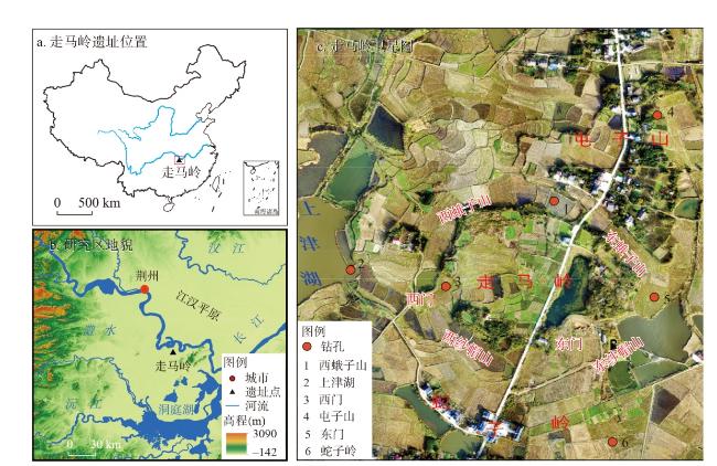
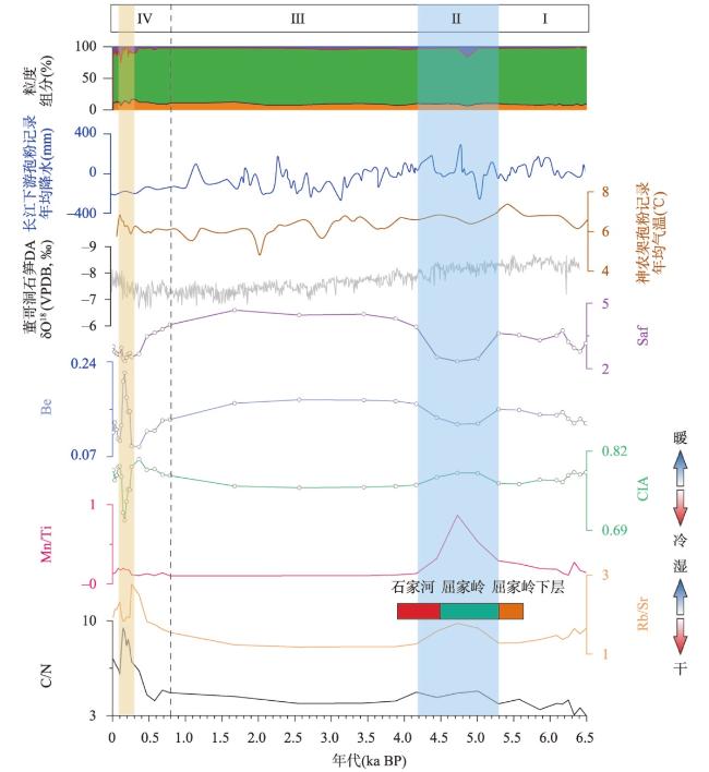
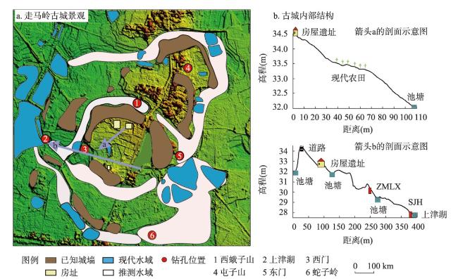
史前城址作为早期城市演化的关键组成部分,与气候、地貌以及水文等区域环境因素密切相关。然而,目前的研究在考虑史前城址相关的区域环境因素方面存在不足。本文基于长江中游地区典型遗址走马岭古城的上津湖钻孔沉积记录和完整的年代框架,结合元素地球化学等气候代用指标分析,重建了中晚全新世走马岭古城遗址的区域沉积环境演变过程,并探讨了其与人类活动的关系。研究发现:① 6.4—5.3 ka BP期间,CIA、Rb/Sr、Mn/Ti值总体较高,Be、Saf值呈相反趋势,指示气候较温暖湿润。此时屈家岭下层文化时期的先民在走马岭修建城址。② 5.3—4.7 ka BP期间,CIA、Rb/Sr、Mn/Ti值上升至峰值,气候暖湿。稻作农业得到发展,屈家岭文化在走马岭古城达到鼎盛。其中4.7—4.6 ka BP期间,粒度参数异常上升,指示古城发生强降水导致的洪水事件。③ 4.7—4.2 ka BP期间,气候转向凉干,古城的石家河文化逐渐衰落。④ 4.2—2.4 ka BP期间,CIA、Rb/Sr、Mn/Ti值降至最低,气候变凉干,古城在3.9 ka BP被废弃。⑤ 2.4—0.3 ka BP期间,CIA和Rb/Sr值回升,Saf和Be值下降,气候回暖。0.8 ka BP左右,上津湖形成。0.3—0.1 ka BP期间,CIA、Rb/Sr值大幅降低,Be和C/N值异常升高,指示在明清小冰期的鼎盛期,走马岭气候寒冷干旱。但是当时围垦等人类活动频繁,初级生产力高。走马岭古城的城内水源主要依赖东南侧的蛇子岭水体,雨季时打开西水门,洪水通过壕沟排入上津湖。旱季时关闭西水门,靠城外蛇子岭水体引水供城内用水。后期气候转向凉干时,水体枯竭导致走马岭古城的壕沟系统失去作用,古城被废弃。

郭爱鹏 , 毛龙江 , 单思伟 , 莫多闻 , 余西云 . 长江中游走马岭古城兴衰的环境背景研究[J]. 地理学报, 2024 , 79(5) : 1211 -1230 . DOI: 10.11821/dlxb202405008
Integral early urban evolution of prehistoric city sites are intimately related to regional environmental factors such as climate, geomorphology, and hydrology. However, current research is inadequate in considering the regional environmental factors associated with prehistoric city sites. This study utilizes the Shangjinhu Lake sedimentary record and a comprehensive chronological framework of the ancient city of Zoumaling, a typical site in the middle Yangtze River. By analyzing climatic proxies such as elemental geochemistry, it offers a reconstruction of the regional depositional environment of the Zoumaling site during the mid-late Holocene. Furthermore, it explores the connection between regional environment and human activities. The study indicates that: (1) During 6.4-5.3 ka BP, the CIA, Rb/Sr, and Mn/Ti values were generally high, and the Be and Saf values showed an opposite trend, indicating a warmer and wetter climate. The ancestors of the lower Qujialing culture constructed the city of Zoumaling. (2) During 5.3-4.7 ka BP, the values of CIA, Rb/Sr, and Mn/Ti reached their peak, and the climate was warm and humid. Rice agriculture flourished and the Qujialing culture in Zomaling city reached its heyday. Specifically, between 4.7 and 4.6 ka BP, a significant rise in grain size parameters indicates that the ancient city was subjected to flood events due to intense precipitation. (3) During 4.7-4.2 ka BP, the climate became cooler and drier. Consequently, the Shijiahe culture within the Zomaling city began to decline gradually. (4) During 4.2-2.4 ka BP, the CIA, Rb/Sr, and Mn/Ti values fell to their lowest, indicating a shift to cooler and drier climate conditions, and the ancient city was abandoned around 3.9 ka BP. (5) During 2.4-0.3 ka BP, CIA and Rb/Sr values rebounded and Saf and Be values decreased, indicating a warming climate. Around 0.8 ka BP, the Shangjinhu Lake was formed. During 0.3-0.1 ka BP, the values of CIA and Rb/Sr decreased sharply, and Be and C/N values increased, indicating a cold and arid climate at Zomaling during the heyday of the Ming-Qing Little Ice Ages. The primary productivity was high due to frequent human activities like land reclamation. The Zomaling city primarily depended on the Sheziling waterbody for its water supply. During the rainy season, the west water gate was opened to release flood water into the Shangjinhu Lake via the trench. During the dry season, the west water gate was closed, and water was drawn from the external Sheziling waterbody to supply the city. In the later period, as the climate turned cooler and drier, the depletion of water bodies caused the moat system of the Zoumaling city to become ineffective, resulting in its abandonment.
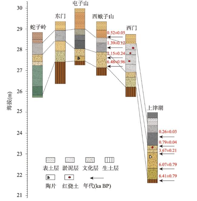
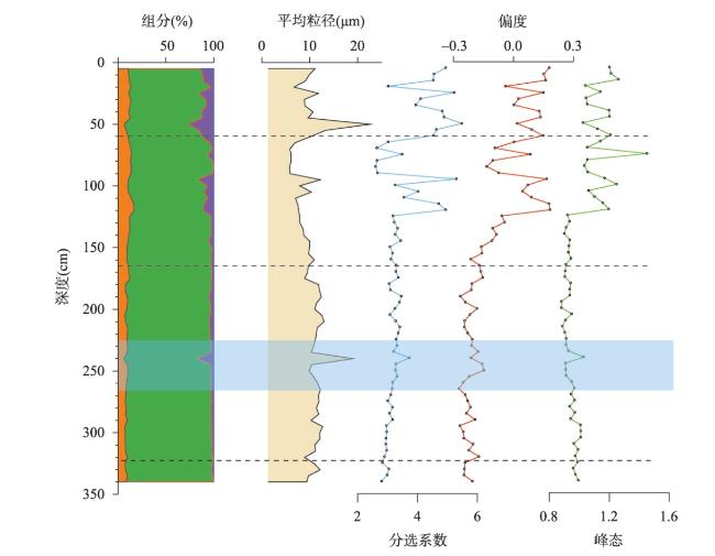
表1 上津湖钻孔岩心的岩性描述Tab. 1 Lithology description of Shangjinhu core |
| 层位 | 深度(cm) | 岩性描述 | |
|---|---|---|---|
| 1 | 0~23 | 稻田土,灰色粉砂质粘土,greenish gray(GLEY 2 5/10G),含植物残体 | |
| 2 | 24~60 | 灰色粘土,brown(GLEY 2 5/10B),含植物残体 | |
| 3 | 61~105 | 灰青色粘土夹灰色粘土,blueish gray(GLEY 2 5/5PB),含近代植物根系 | |
| 4 | 104~165 | 黑色粘土,very dark gray(GLEY 2 4/5PB) | |
| 5 | 166~182 | 灰黄色粘土含斑块状灰色粘土,dark yellowish brown(10YR 4/4),含红烧土 | |
| 6 | 183~197 | 质地、颜色同上,斑块状粘土部分增多 | |
| 7 | 198~272 | 棕色颗粒状粘土,brown(7.5YR 4/3),含陶片和黑色铁锰结核颗粒 | |
| 8 | 273~323 | 粉砂质粘土含青灰色条带,yellowish brown(10YR 5/6),含少量铁锰结核 | |
| 9 | 324~340 | 生土层,未见底,颜色同上,条带状粉砂质粘土增加 | |
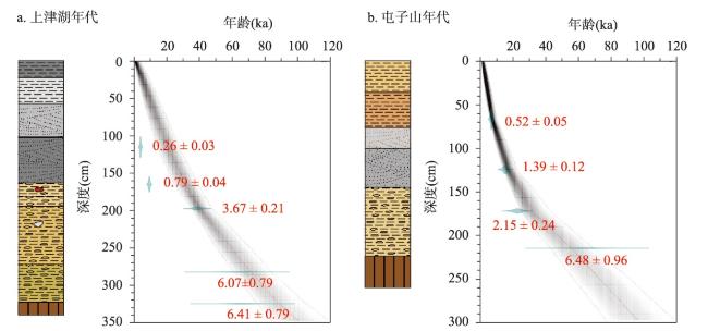
表2 上津湖岩心和屯子山岩心OSL测年结果Tab. 2 OSL dating results from Shangjinhu and Tunzishan cores |
| 样品编号(OSL) | 深度(cm) | U(mg/kg) | Th(mg/kg) | K(mg/kg) | 剂量率 (Gy/ka) | 测片数 | 离散度(%) | MAM-De(Gy) | 年代(ka BP) |
|---|---|---|---|---|---|---|---|---|---|
| SJH-01 | 115.0 | 3.39±0.10 | 16.10±0.48 | 2.26±0.07 | 3.91±0.16 | 21 | 18±3 | 1.01±0.09 | 0.26±0.03 |
| SJH-02 | 165.0 | 3.33±0.10 | 14.60±0.44 | 1.50±0.05 | 3.14±0.13 | 24 | 14±2 | 2.48±0.08* | 0.79±0.04* |
| SJH-03 | 197.5 | 2.84±0.09 | 14.10±0.42 | 1.35±0.04 | 2.86±0.12 | 23 | 43±6 | 10.51±0.41 | 3.67±0.21 |
| SJH-04 | 242.5 | 3.60±0.11 | 13.40±0.40 | 1.45±0.04 | 3.06 ±0.13 | 24 | 47±7 | 21.28±2.07 | 6.95 ± 0.73 |
| SJH-05 | 282.5 | 2.86±0.09 | 15.60±0.47 | 1.70±0.05 | 3.25±0.13 | 22 | 47±7 | 19.73±2.42 | 6.07±0.79 |
| SJH-06 | 325.0 | 3.42±0.10 | 16.20±0.50 | 1.63±0.05 | 3.35±0.14 | 28 | 60±8 | 21.46±2.48 | 6.41±0.79 |
| TZS-01 | 67.5 | 3.09±0.09 | 16.70±0.50 | 1.78±0.05 | 3.49±0.14 | 24 | 19±3 | 1.81±0.15 | 0.52±0.05 |
| TZS-02 | 125.0 | 2.71±0.08 | 14.10±0.42 | 1.54±0.05 | 3.01±0.12 | 24 | 21±3 | 4.17±0.33 | 1.39±0.12 |
| TZS-03 | 172.5 | 2.97±0.09 | 15.20±0.46 | 1.64±0.05 | 3.22±0.13 | 27 | 33±5 | 6.90±0.70 | 2.15±0.24 |
| TZS-04 | 215.0 | 2.64±0.08 | 15.80±0.47 | 1.70±0.05 | 3.23±0.13 | 29 | 45±6 | 20.89±2.96 | 6.48±0.96 |
注:样品的含水率为估算值,皆为20%±5%;MAM为最小年龄模型;样品离散度大于15%的样品又利用MAM(sigma b =0.15)进行了计算;U、Th、K的含量通过ICP-MS进行测量;*表示数据用中央年龄模型(CAM)计算。 |
图7 上津湖岩心的古气候代用指标和粒度组分与董哥洞石笋DA的δ18O序列、基于神农架孢粉记录重建的年平均气温[63]以及基于长江下游孢粉记录重建的年均降水量[59]对比Fig. 7 Comparison of paleoclimate proxies and grain size fractions from Shangjinhu core with the δ18O sequence of Dongge stalagmite DA, mean annual temperatures based on the Shennongjia pollen records, and mean annual precipitation based on the downstream of Yangtze River pollen records |
| [1] |
|
| [2] |
|
| [3] |
[吕厚远. 周期性气候变化与人类适应. 人类学学报, 2022, 41(4): 731-748.]
|
| [4] |
[夏正楷, 杨晓燕. 我国北方4 ka BP前后异常洪水事件的初步研究. 第四纪研究, 2003, 23(6): 667-674.]
|
| [5] |
|
| [6] |
|
| [7] |
|
| [8] |
[朱艳, 陈发虎, 张家武, 等. 距今五千年左右环境恶化事件对我国新石器文化的影响及其原因的初步探讨. 地理科学进展, 2001, 20(2): 111-121.]
|
| [9] |
|
| [10] |
|
| [11] |
|
| [12] |
[徐旺生. 农业起源: 中纬度地区冰后期贮藏行为的产物. 古今农业, 2013(3): 44-49.]
|
| [13] |
|
| [14] |
[陈冬仿. 环壕的发展与城的起源. 中原文物, 2015(6): 42-45.]
|
| [15] |
Hunan Provincial Institute of Cultural Relics and Archaeology. Pengtoushan Site and Bashidang Site. Beijing: Science Press, 2006.
[湖南省文物考古研究院. 彭头山与八十垱. 北京: 科学出版社, 2006.]
|
| [16] |
[郭伟民. 新石器时代澧阳平原与汉东地区的文化和社会. 北京: 文物出版社, 2010.]
|
| [17] |
[刘辉. 长江中游史前城址的聚落结构与社会形态. 江汉考古, 2017(5): 41-51.]
|
| [18] |
[王良智. 长江中游新石器文化时空框架与谱系研究[D]. 济南: 山东大学, 2023.]
|
| [19] |
Hunan Provincial Institute of Cultural Relics and Archaeology. Chengtoushan Site in Lixian County. Beijing: Cultural Relics Press, 2007.
[湖南省文物考古研究所. 澧县城头山. 北京: 文物出版社, 2007.]
|
| [20] |
|
| [21] |
[单思伟. 屈家岭文化研究[D]. 武汉: 武汉大学, 2019.]
|
| [22] |
|
| [23] |
|
| [24] |
[李俊, 王淑云, 莫多闻. 6000 a BP以来洞庭湖沉积记录的环境演变及其同人类活动的关系. 北京大学学报(自然科学版), 2011, 47(6): 1041-1048.]
|
| [25] |
[夏志锋, 孔兴功, 汪永进, 等. 东亚季风95—56 ka BP期间D/O事件年代的精确测定: 以中国神农架山宝洞石笋为例. 中国科学: 地球科学, 2006, 36(9): 830-837.]
|
| [26] |
[邓辉, 陈义勇, 贾敬禹, 等. 8500 a BP以来长江中游平原地区古文化遗址分布的演变. 地理学报, 2009, 64(9): 1113-1125.]
|
| [27] |
[吴立. 江汉平原中全新世古洪水事件环境考古研究[D]. 南京: 南京大学, 2013.]
|
| [28] |
[陈官涛. 湖北石首市走马岭新石器时代遗址发掘简报. 考古, 1998(4): 16- 38, 101-104.]
|
| [29] |
[单思伟, 余西云. 湖北石首市走马岭新石器时代城址的发掘. 考古, 2018(9): 5-27.]
|
| [30] |
|
| [31] |
[马小姣, 赵冰竹, 单思伟, 等. 湖北石首走马岭遗址周边史前遗址调查简报. 江汉考古, 2017(1): 3-12.]
|
| [32] |
[唐丽雅, 刘嘉祺, 单思伟, 等. 湖北石首走马岭遗址史前植物遗存鉴定与研究. 江汉考古, 2021(3): 109-115.]
|
| [33] |
[贺成坡, 李英华, 韦璇, 等. 湖北石首市走马岭遗址石器原料溯源分析. 四川文物, 2021(6): 43-51.]
|
| [34] |
[陶建平. 长江中游平原农业洪涝灾害风险管理研究[D]. 武汉: 华中农业大学, 2004.]
|
| [35] |
[马芳宇. 江汉平原富硒土壤与农产品质量初探. 资源环境与工程, 2012, 26(2): 194-200.]
|
| [36] |
[刘建国. 江汉平原史前治水文明. 北京: 中国社会科学出版社, 2023.]
|
| [37] |
[朱道清. 中国水系大辞典. 青岛: 青岛出版社, 1993.]
|
| [38] |
|
| [39] |
|
| [40] |
[谈梦婷, 李华, 何幼斌, 等. 鄂尔多斯盆地西缘奥陶系拉什仲组复合水道沉积特征及演化. 古地理学报, 2023, 25(1): 119-132.]
|
| [41] |
|
| [42] |
|
| [43] |
|
| [44] |
|
| [45] |
|
| [46] |
|
| [47] |
|
| [48] |
|
| [49] |
|
| [50] |
[秦伯强, 许海, 董百丽. 富营养化湖泊治理的理论与实践. 北京: 高等教育出版社, 2011.]
|
| [51] |
|
| [52] |
[吴立. 巢湖流域新石器至汉代古聚落变更与环境变迁[D]. 芜湖: 安徽师范大学, 2010.]
|
| [53] |
[刘飞. 东海岛屿黄土与下蜀黄土古环境信息研究[D]. 上海: 华东师范大学, 2006.]
|
| [54] |
|
| [55] |
|
| [56] |
|
| [57] |
[王红星. 屈家岭:长江中游的史前文化. 北京: 文物出版社, 2007.]
|
| [58] |
[吴立, 朱诚, 李枫, 等. 江汉平原钟桥遗址地层揭示的史前洪水事件. 地理学报, 2015, 70(7): 1149-1164.]
|
| [59] |
|
| [60] |
[史辰羲, 莫多闻, 刘辉, 等. 江汉平原北部汉水以东地区新石器晚期文化兴衰与环境的关系. 第四纪研究, 2010, 30(2): 335-343.]
|
| [61] |
[翟世航. 明清时期江汉平原环境变迁研究[D]. 武汉: 华中师范大学, 2011.]
|
| [62] |
[方修琦, 萧凌波, 魏柱灯. 18—19世纪之交华北平原气候转冷的社会影响及其发生机制. 中国科学: 地球科学, 2013, 43(5): 825-838.]
|
| [63] |
|
| [64] |
[毛俊翔. 地貌学及第四纪地质学在考古学中的应用. 客家文博, 2016(2): 16-21.]
|
| [65] |
[柏道远. 洞庭盆地第四纪地质环境演化[D]. 武汉: 中国地质大学, 2011.]
|
| [66] |
[刘建国. 江汉平原史前人地关系研究. 南方文物, 2022(6): 27-34.]
|
| [67] |
[单思伟, 彭蛟. 走马岭史前城址结构与功能探索. 南方文物, 2022(6): 40-48.]
|
| [68] |
[程鹏举. 古代荆江堤防的管理. 中国水利, 1990(5): 40-41.]
|
| [69] |
[郭立新, 郭静云. 中国最早城市体系研究(二). 南方文物, 2021(2): 14-31.]
|
| [70] |
[单思伟. 屈家岭下层文化的界定、时空结构及相关问题. 四川文物, 2021(4): 30-42.]
|
/
| 〈 |
|
〉 |
