
若尔盖盆地黄土—古土壤序列化学风化特征及环境意义
|
赵晓康(1998-), 男, 山西临汾人, 硕士生, 研究方向为环境演变。E-mail: zhaoxiaokang0302@163.com |
收稿日期: 2023-07-12
修回日期: 2024-03-17
网络出版日期: 2024-05-31
基金资助
国家自然科学基金项目(42271046)
国家自然科学基金项目(42277449)
国家自然科学基金项目(41971116)
国家自然科学基金项目(42071112)
Chemical weathering characteristics and environmental significance of the aeolian loess-paleosol sequence of Zoige Basin
Received date: 2023-07-12
Revised date: 2024-03-17
Online published: 2024-05-31
Supported by
National Natural Science Foundation of China(42271046)
National Natural Science Foundation of China(42277449)
National Natural Science Foundation of China(41971116)
National Natural Science Foundation of China(42071112)
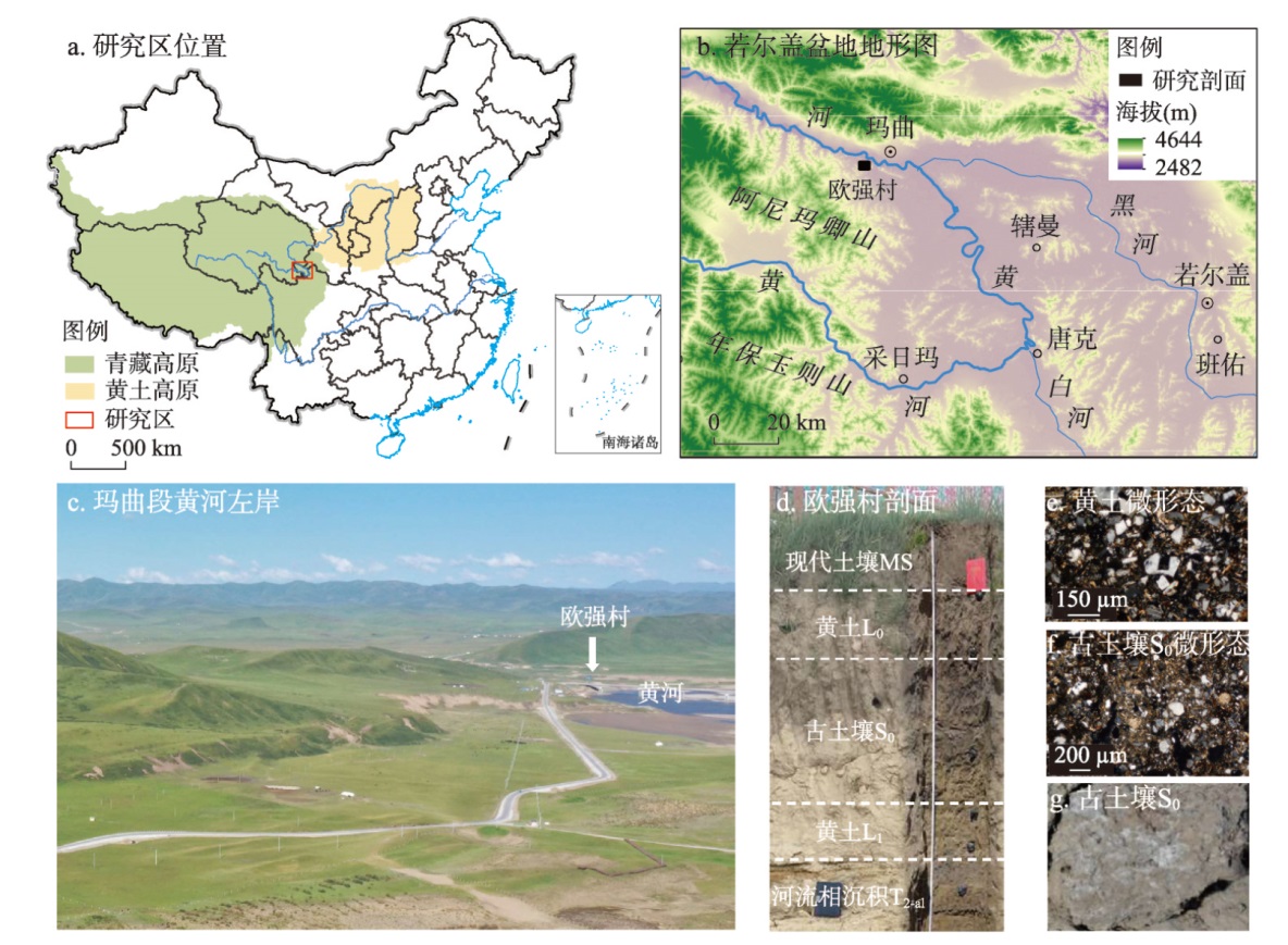
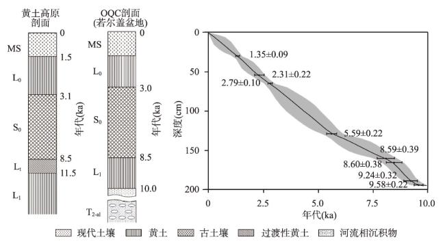
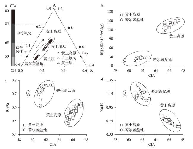
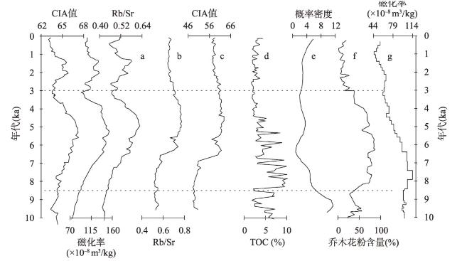
若尔盖盆地黄土—古土壤序列较好地记录了古湖泊消失后的地表过程及演变。本文选取玛曲段黄河二级阶地欧强村剖面为研究对象,对其粒度、磁化率、总有机碳(TOC)、色度、元素等进行分析,利用光释光(OSL)方法测年断代。结果表明:① 黄河二级阶地在10 ka BP前后开始接受连续的风尘堆积,发育的黄土—古土壤序列年代由下至上依次为河流相沉积物(T2-al, >10.0 ka)→黄土(L1,10.0—8.5 ka)→古土壤(S0,8.5—3.0 ka)→现代表土(L0+MS,3.0—0 ka)。② 欧强村剖面整体上处于以斜长石风化分解为主、钾长石尚未分解的初等化学风化阶段(CIA值在48.20~63.08之间),与黄土层相比,古土壤S0风化程度有所增强(CIA值60.83),但增强程度有限。③ 10 ka BP前后,若尔盖盆地气候干冷,风沙活动盛行,平缓的阶地面上开始接受持续的风尘堆积(形成黄土L1);8.5 ka BP前后,气候温湿,风沙活动明显减弱和风化成壤作用占主导,区域上形成了以黑灰色为特征的古土壤S0;3.0 ka BP前后,气候转为较冷干,风沙活动强烈,古土壤S0发育中断和被黄土L0所覆盖,形成了现代土壤MS。④ 若尔盖盆地黄土—古土壤序列在宏观形态、地层年代和物性参数方面与黄土高原可进行良好对比,但这些参数的绝对值和变化幅度差异显著,暗示高寒区(若尔盖盆地)这些参数的环境意义可能与季风湿润区(黄土高原)有所不同。本文可为若尔盖盆地风积物的年代学研究和环境信息的提取提供基础数据支撑。
赵晓康 , 庞奖励 , 黄春长 , 周亚利 , 查小春 , 李瑜琴 , 张玉柱 , 王忻宇 . 若尔盖盆地黄土—古土壤序列化学风化特征及环境意义[J]. 地理学报, 2024 , 79(5) : 1177 -1191 . DOI: 10.11821/dlxb202405006
The loess-paleosol sequence in the Zoige Basin is a geological record of the surface processes and evolution after the paleolake disappeared in this region. The Ouqiangcun (OQC) profile of the secondary terrace of the Yellow River in the Maqu reach was selected as the focus of this study. Based on the comprehensive investigation of multiple proxies, such as the grain-size distribution, magnetic susceptibility, total organic carbon, chroma, elements, and optically stimulated luminescence age, the following conclusions were obtained: (1) Continuous aeolian dust accumulation began on the Yellow River secondary terrace around 10 ka BP, and the developed loess-paleosol sequence from bottom to top was fluvial sediment (T2-al, >10.0 ka)→loess (L1, 10.0-8.5 ka)→paleosol (S0, 8.5-3.0 ka)→topsoil (L0+MS, 3.0-0 ka). (2) The OQC profile was in the primary chemical weathering stage where plagioclase was mainly decomposed and potassium feldspar was not decomposed (CIA value is between 48.20 and 63.08). While the paleosol was slightly increased when compared with the loess layers, this enhancement was limited, and it had not progressed to the moderate weathering stage. (3) Around 10 ka BP, the climate of the Zoige Basin was dry and cold, aeolian sand activity was prevalent, and continuous wind-dust accumulation began to occur on the gentle terrace, which formed loess L1. Around 8.5 ka BP, the climate was warm and humid, the activity of the aeolian sand was obviously weakened, and the weathering of the pedogenesis was dominant. Paleosol with black and gray characteristics was formed during this period. Around 3.0 ka BP, the climate changed to cold and dry and the aeolian sand activity was intense. The development of paleosol was interrupted, it was covered by loess L0, and the modern soil was formed. (4) The loess-paleosol sequence of the Zoige Basin was significantly different in terms of the macroscopic morphology, stratigraphic age and physical property parameters when compared with those of the Loess Plateau. This suggests that the environmental significance of these parameters in the high-cold area (Zoige Basin) may be different from that in the monsoon humid area (Loess Plateau). The findings provide basic data to support the study of the chronology of aeolian sediments and the extraction of environmental information in the Zoige Basin.
Key words: Zoige Basin; loess-paleosol sequence; OQC profile; degree of weathering; OSL dating
表1 若尔盖盆地玛曲段黄河二级阶地欧强村剖面地层特征描述Tab. 1 Stratigraphic characteristics of the OQC profile of the secondary terrace of the Yellow River in the Maqu reach of Zoige Basin |
| 地层 | 深度(cm) | 土壤学与沉积学特征描述 |
|---|---|---|
| 现代土壤(MS) | 0~30 | 浊黄棕色(10YR4/3),细砂质粉砂质地,团粒—团块结构,疏松多孔,含有密集的植物根系。 |
| 黄土(L0) | 30~70 | 浊黄棕色(10YR4/3),细砂质粉砂质地,块状结构,比较疏松,根系减少。 |
| 古土壤(S0) | 70~160 | 灰黄棕色(10YR5/2),细砂质粉砂质地,团粒—团块结构,致密紧实,含有大小孔隙,白色碳酸盐假菌丝体沿孔隙分布。 |
| 黄土(L1) | 160~200 | 浊黄橙色(10YR6/3),细砂质粉砂质地,块状结构,多细小孔隙,下界清晰。 |
| 河流相沉积物(T2-al) | >200 | 亮黄棕色(10YR6/4),细砂质地,比较疏松,干净,有较为明显的水平层理。 |
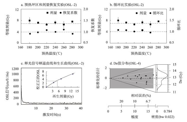
表2 若尔盖盆地玛曲段黄河二级阶地欧强村剖面OSL测年结果Tab. 2 The OSL dating results of the OQC profile of the secondary terrace of the Yellow River in the Maqu reach of Zoige Basin |
| 编号 | 深度(cm) | 地层 | U(10-6) | Th(10-6) | K(%) | 含水量 (%) | 环境剂量率 (Gy ka-1) | 等效剂量(Gy) | OSL年龄 (ka) |
|---|---|---|---|---|---|---|---|---|---|
| OSL-1 | 30 | MS底部 | 1.54±0.30 | 8.28±0.60 | 1.71±0.04 | 20±3 | 2.45±0.08 | 3.30±0.19 | 1.35±0.09 |
| OSL-2 | 55 | L0中部 | 1.09±0.30 | 8.07±0.60 | 1.68±0.04 | 20±3 | 2.37±0.08 | 5.48±0.48 | 2.31±0.22 |
| OSL-3 | 65 | L0底部 | 1.29±0.30 | 8.07±0.60 | 1.72±0.04 | 20±3 | 2.45±0.08 | 6.81±0.14 | 2.79±0.10 |
| OSL-4 | 130 | S0中部 | 1.48±0.30 | 8.68±0.60 | 1.53±0.04 | 21±3 | 2.30±0.08 | 12.86±0.24 | 5.59±0.22 |
| OSL-5 | 160 | S0底部 | 1.51±0.30 | 8.74±0.60 | 1.57±0.04 | 20±3 | 2.37±0.07 | 20.35±0.68 | 8.59±0.39 |
| OSL-6 | 165 | L1顶部 | 1.42±0.30 | 8.94±0.60 | 1.54±0.04 | 21±3 | 2.31±0.07 | 19.68±0.43 | 8.60±0.38 |
| OSL-7 | 190 | L1底部 | 1.43±0.30 | 8.14±0.60 | 1.58±0.04 | 21±3 | 2.20±0.07 | 20.29±0.43 | 9.24±0.32 |
| OSL-8 | 195 | L1底部 | 1.40±0.40 | 8.08±0.70 | 1.54±0.04 | 21±3 | 2.17±0.07 | 20.79±0.84 | 9.58±0.20 |
| OSL-9 | 650 | T2-al上部 | 1.01±0.30 | 5.82±0.60 | 1.47±0.04 | 22±3 | 1.86±0.06 | 24.57±0.92 | 13.20±0.67 |
注:OSL-9数据来自于文献[5]。 |
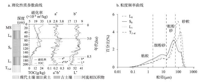
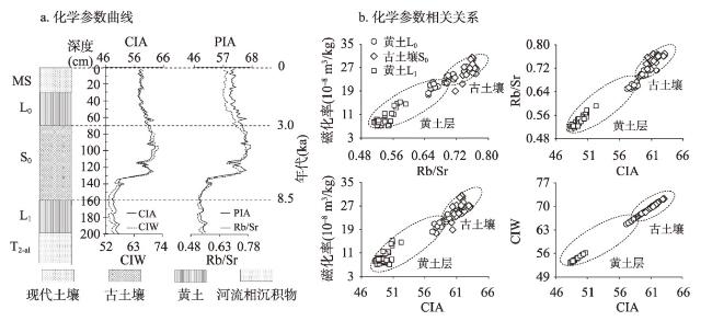
图3 若尔盖盆地玛曲段黄河二级阶地欧强村剖面理化性质参数曲线Fig. 3 Parameter curves of physicochemical properties of the OQC profile of the secondary terrace of the Yellow Riverin the Maqu reach of Zoige Basin |
表3 若尔盖盆地玛曲段黄河二级阶地欧强村剖面粒度特征Tab. 3 Characteristic values of grain-size of the OQC profile of the secondary terrace of the Yellow Riverin the Maqu reach of Zoige Basin |
| 地层 | 深度(cm) | 粘粒 (%) | 细粉砂 (%) | 粗粉砂 (%) | 细砂 (%) | 中砂 (%) | 平均粒径 (μm) | 标准 偏差 | 偏度 | 峰态 | 分选 系数 |
|---|---|---|---|---|---|---|---|---|---|---|---|
| MS | ≤ 200 | 9.6 | 20.5 | 26.8 | 23.6 | 19.5 | 63.55 | 2.40 | 0.46 | 0.92 | 1.71 |
| L0 | 9.5 | 19.4 | 26.2 | 23.5 | 21.4 | 66.67 | 2.42 | 0.47 | 0.95 | 1.68 | |
| S0 | 13.5 | 28.0 | 34.3 | 15.7 | 8.5 | 38.14 | 2.44 | 0.34 | 0.90 | 1.76 | |
| L1 | 10.7 | 24.6 | 36.9 | 20.4 | 7.4 | 41.87 | 2.27 | 0.42 | 0.98 | 1.56 | |
| T2-al | > 200 | 8.6 | 18.4 | 26.1 | 35.6 | 11.3 | 59.22 | 2.18 | 0.59 | 1.00 | 1.44 |
注:粘粒<2 μm、细粉砂2~16 μm、粗粉砂16~63 μm、细砂63~125 μm、中砂>125 μm。 |
表4 若尔盖盆地玛曲段黄河二级阶地欧强村剖面常量元素含量(g/kg)Tab. 4 The major element contents of the OQC profile of the secondary terrace of the Yellow River in the Maqu reach of Zoige Basin (g/kg) |
| 地层 | SiO2 | Al2O3 | Fe2O3 | CaO | MgO | K2O | Na2O |
|---|---|---|---|---|---|---|---|
| MS | 696.9 654.1~712.7 | 106.2 100.9~114.8 | 34.7 33.6~36.3 | 12.9 11.3~14.5 | 11.3 10.5~12.9 | 20.2 19.5~21.6 | 19.3 18.6~21.1 |
| L0 | 691.0 671.2~703.6 | 112.7 105.5~125.3 | 36.7 33.6~39.3 | 13.3 11.7~15.5 | 12.4 11.3~14.8 | 21.3 19.6~23.7 | 18.8 17.2~19.8 |
| S0 | 654.4 613.7~679.4 | 127.0 121.1~131.0 | 42.8 40.0~44.5 | 22.0 11.6~47.7 | 15.0 13.7~15.8 | 23.0 21.3~24.3 | 17.3 16.1~19.6 |
| L1 | 629.6 614.6~642.6 | 122.0 116.3~130.1 | 42.7 39.6~48.6 | 42.7 38.8~45.4 | 14.9 13.6~16.5 | 21.4 20.4~22.9 | 17.7 16.2~18.6 |
| 全剖面 | 663.1 613.7~712.7 | 119.5 100.9~131 | 40.1 33.6~48.6 | 23.8 11.3~47.7 | 13.8 10.5~16.5 | 21.9 19.5~24.3 | 18.1 16.1~21.1 |
| CV | 0.04 | 0.07 | 0.09 | 0.59 | 0.11 | 0.06 | 0.05 |
| [1] |
[李世杰, 施雅风, 王苏民. 若尔盖盆地3万年来气候与环境变化的地质记录//青藏项目专家委员会.青藏高原形成演化、环境变迁与生态系统研究. 北京: 科学出版社, 1995: 227-235.]
|
| [2] |
|
| [3] |
[黄春长. 若尔盖盆地河流古洪水沉积及其对黄河水系演变问题的启示. 地理学报, 2021, 76(3): 612-625.]
|
| [4] |
[王云飞, 王苏民, 薛滨, 等. 黄河袭夺若尔盖古湖时代的沉积学依据. 科学通报, 1995, 40(8): 723-725.]
|
| [5] |
|
| [6] |
|
| [7] |
|
| [8] |
|
| [9] |
[孙晓红, 赵艳, 李泉. 青藏高原东部若尔盖盆地全新世泥炭地发育和植被变化. 中国科学: 地球科学, 2017, 47(9): 1097-1109.]
|
| [10] |
[汪洪娇, 曾蒙秀, 彭海军, 等. 红原泥炭记录的晚冰期以来若尔盖地区粉尘通量变率及其气候影响. 第四纪研究, 2023, 43(1): 57-73.]
|
| [11] |
|
| [12] |
[胡光印, 董治宝, 张正偲, 等. 若尔盖盆地起沙风风况与输沙势特征. 中国沙漠, 2020, 40(5): 20-24.]
|
| [13] |
[魏振海, 董治宝, 胡光印, 等. 近 40a 来若尔盖盆地沙丘时空变化. 中国沙漠, 2010, 30(1): 26-32.]
|
| [14] |
[胡梦珺, 杨爱丽, 张文丽. 常量元素氧化物含量及其比值揭示的中晚全新世以来玛曲高原的环境演变. 中国沙漠, 2015, 35(2): 313-321.]
|
| [15] |
|
| [16] |
[韩宜欣, 查小春, 黄春长, 等. 若尔盖盆地黄河出口段一级阶地沉积序列及其环境变化研究. 地理科学, 2023, 43(5): 922-931.]
|
| [17] |
|
| [18] |
[王曼华. 若尔盖高原区泥炭地的孢粉组合及古植被与古气候. 地理科学, 1987, 7(2): 147-155.]
|
| [19] |
[王海燕. 青藏高原东北缘喇家遗址覆盖沉积物性质及史前灾难成因研究[D]. 西安: 陕西师范大学, 2021.]
|
| [20] |
|
| [21] |
[炊郁达, 黄春长, 庞奖励, 等. 青海喇家遗址土壤序列及史前山洪泥流灾难释光测年研究. 地理学报, 2019, 74(11): 2371-2384.]
|
| [22] |
|
| [23] |
|
| [24] |
[王丽娟, 庞奖励, 黄春长, 等. 甜水沟全新世黄土—古土壤序列风化程度及意义. 地理科学进展, 2011, 30(3): 379-384.]
|
| [25] |
|
| [26] |
[董苗, 严平, 王晓旭, 等. 青藏高原不同气候带爬坡沙丘沉积物特征及其环境指示. 地理学报, 2023, 78(7): 1825-1846.]
|
| [27] |
|
| [28] |
|
| [29] |
|
| [30] |
|
| [31] |
[陈豆, 肖奇立, 张玉柱, 等. 黄河源玛曲段全新世风成黄土—古土壤序列风化成壤特征以及古气候演变. 地理研究, 2022, 41(8): 2277-2294.]
|
| [32] |
[庞奖励, 黄春长, 周亚利, 等. 汉江上游谷地全新世风成黄土及其成壤改造特征. 地理学报, 2011, 66(11): 1562-1573.]
|
| [33] |
|
| [34] |
[贾蓉芬, 赵林, 刘友梅, 等. 黄土地区气候演变的有机地球化学标志. 地理科学, 1996, 16(2): 97-105.]
|
| [35] |
|
| [36] |
[王燕, 赵志中, 乔彦松, 等. 川北若尔盖高原红原泥炭剖面孢粉记录的晚冰期以来古气候古环境的演变. 地质通报, 2006, 25(7): 827-832.]
|
| [37] |
[梁琛, 赵艳, 秦锋, 等. 孢粉—气候定量重建方法体系的建立及其应用: 以青藏高原东部全新世温度重建为例. 中国科学: 地球科学, 2020, 50(7): 977-994.]
|
| [38] |
|
| [39] |
|
| [40] |
|
| [41] |
[侯光良, 魏海成, 鄂崇毅, 等. 青藏高原东北缘全新世人类活动与环境变化: 以青海湖江西沟2号遗迹为例. 地理学报, 2013, 68(3): 380-388.]
|
| [42] |
[王富葆, 阎革, 林本海. 若尔盖高原泥炭δ13C的初步研究. 科学通报, 1993, 38(1): 65-67.]
|
| [43] |
[何文贵, 熊振, 袁道阳, 等. 东昆仑断裂带东段玛曲断裂古地震初步研究. 中国地震, 2006, 22(2): 126-134.]
|
| [44] |
[綦琳, 王燕, 蔡遥, 等. 若尔盖风成砂—古土壤序列的古气候与古环境记录研究. 地质力学学报, 2020, 26(2): 244-251.]
|
| [45] |
[胡梦珺, 左海玲, 潘宁惠, 等. 中晚全新世以来玛曲高原的化学风化过程演变. 中国沙漠, 2016, 36(3): 623-635.]
|
/
| 〈 |
|
〉 |