
中国国土空间布局优化研究
|
董寅(1992-), 男, 湖北宜昌人, 博士, 讲师, 主要从事国土空间优化利用与管理研究。E-mail: dongy_simlab@163.com |
收稿日期: 2023-09-26
修回日期: 2024-02-28
网络出版日期: 2024-04-02
基金资助
国家自然科学基金项目(71974070)
国家自然科学基金项目(72221002)
Optimization of territorial space layout in China
Received date: 2023-09-26
Revised date: 2024-02-28
Online published: 2024-04-02
Supported by
National Natural Science Foundation of China(71974070)
National Natural Science Foundation of China(72221002)
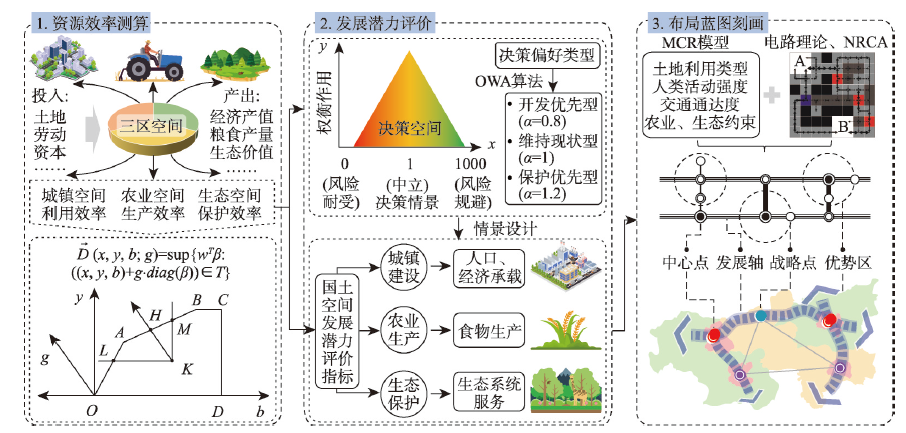
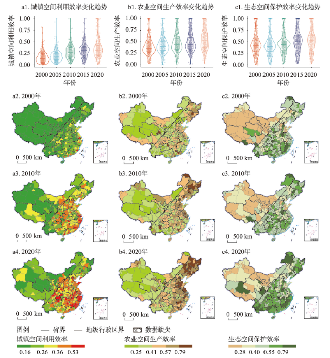
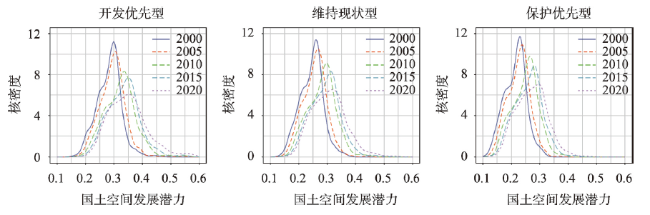
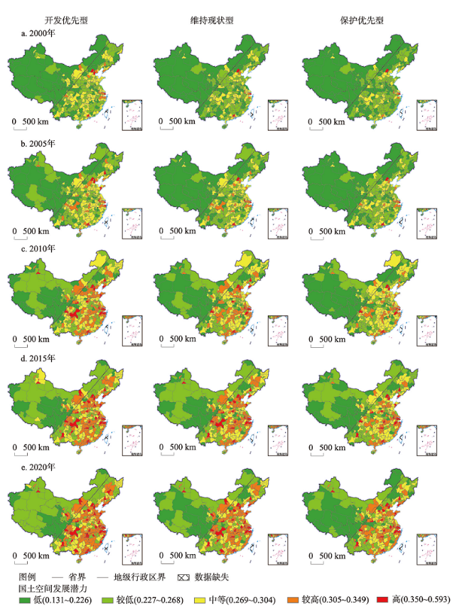
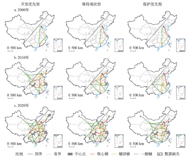
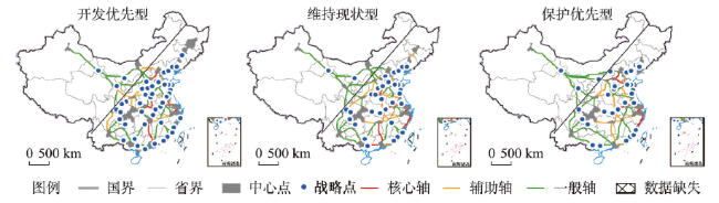
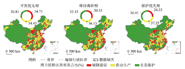
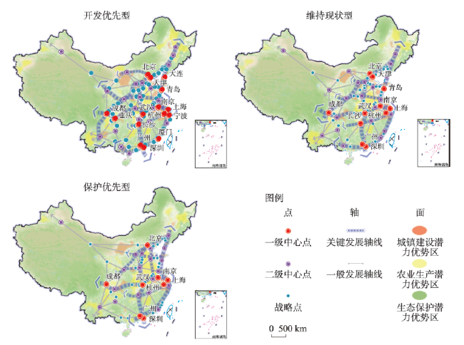
国土空间发展格局事关经济发展、社会福祉与生态安全,而资源效率成为空间冲突加剧、资源约束趋紧背景下科学优化国土空间布局的基础支撑。本文基于全国市域国土资源效率值设计国土空间开发保护情景方案并评价不同偏好下的国土空间发展潜力,进而定量刻画“点—轴—面”一体化的国土空间布局蓝图。结果表明:① 中国国土资源效率稳步上升但整体水平偏低,区域间发展不均衡。② 研究期内中国国土空间发展潜力持续提升,开发导向下潜力水平相较更高,且不同情景下潜力高值区围绕城市群地区向外轴向扩散。③ 中心点与发展轴线的分布格局经历了由“三足鼎立”向菱形结构演化的过程,其中沿海通道、京哈—京广通道及沿江通道的主体地位突出。④ 战略点向关键轴线有序集聚,优势区在胡焕庸线两侧呈明显分化。组合国土空间结构要素分别形成开发优先、维持现状与保护优先3类情景下“五横三纵,八核三区”“四横三纵,六核三区”与“三横四纵,五核三区”的国土空间布局蓝图。本文研究结果可为实现高质量国土空间发展格局与美丽国土愿景提供技术依据和理论支撑。
董寅 , 金贵 , 邓祥征 . 中国国土空间布局优化研究[J]. 地理学报, 2024 , 79(3) : 672 -687 . DOI: 10.11821/dlxb202403008
The evolution of territorial space is intrinsically linked to economic growth, societal welfare, and ecological preservation. In the context of escalating spatial conflicts and stringent resource limitations, resource efficiency has emerged as a fundamental pillar for the scientific optimization of territorial space layout. Drawing upon resource efficiency metrics from cities nationwide, this study constructs scenarios for territorial space development and conservation. It assesses developmental capacity under varying preferences and subsequently delineates strategic blueprints using an integrated "point-axis-area" approach. The findings reveal that: (1) Resource efficiency in China has witnessed a consistent uptick, yet remains modest overall, with marked regional disparities. (2) Throughout the investigation period, developmental capacity has seen progressive enhancement, with a pronounced capacity in scenarios favoring development, radiating axially from urban conglomerates. (3) The layout of pivotal points and developmental axes has transitioned from a "tri-pillar" to a diamond configuration, with the coastal corridor, the Harbin-Beijing-Guangzhou corridor and the corridor along the Yangtze River standing out. (4) Strategic points progressively converge along key axes, while dominant regions exhibit clear differentiation on either side of the Hu Huanyong Line. By integrating elements of the territorial spatial structure, this paper proposes blueprints for "five horizontal and three vertical zones with eight cores and three areas", "four horizontal and three vertical zones with six cores and three areas" and "three horizontal and four vertical zones with five cores and three areas", corresponding to scenarios prioritizing development, status quo maintenance, and conservation, respectively. The outcomes of this research offer a technical foundation and theoretical guidance for the pursuit of high-quality territorial space development and the vision of a picturesque landscape.
表1 国土资源效率评估指标体系Tab. 1 Evaluation indicator system of resource efficiency |
| 效率类型 | 要素 | 指标类型 | 具体指标 | 单位 | 参考文献 |
|---|---|---|---|---|---|
| 城镇空间 利用效率 | 生产投入 | 土地投入 | 城市建设用地面积 | km2 | - |
| 劳动投入 | 非农从业人口 | 万人 | - | ||
| 资本投入 | 固定资本存量 | 亿元 | [28] | ||
| 期望产出 | 经济产出 | 非农产值 | 亿元 | - | |
| 社会效益 | 城镇职工平均工资 | 元 | - | ||
| 非期望产出 | 污染排放 | 工业废水排放量 | 万t | - | |
| 工业二氧化硫排放量 | t | - | |||
| 工业烟(粉)尘排放量 | t | - | |||
| 农业空间 生产效率 | 生产投入 | 土地投入 | 农作物播种面积 | 千hm2 | - |
| 劳动投入 | 农业从业人员 | 万人 | - | ||
| 机械投入 | 农业机械总动力 | 万kW | - | ||
| 用水投入 | 有效灌溉面积 | 千hm2 | - | ||
| 化肥投入 | 化肥施用量 | 万t | - | ||
| 农药投入 | 农药使用量 | 万t | - | ||
| 农膜投入 | 农膜使用量 | 万t | - | ||
| 能源投入 | 农用柴油使用量 | 万t | - | ||
| 期望产出 | 经济产出 | 农业总产值 | 亿元 | - | |
| 社会效益 | 粮食产量 | 万t | - | ||
| 非期望产出 | 污染排放 | 农业面源污染排放 | 万t | [29] | |
| 农业碳排放量 | 万t | [30] | |||
| 生态空间 保护效率 | 生产投入 | 土地投入 | 生态用地面积 | km2 | [31] |
| 劳动投入 | 水利、环境和公共设施管理业就业人数 | 万人 | - | ||
| 资本投入 | 水利、环境和公共设施管理业固定资产投资 | 万元 | - | ||
| 农林水事务财政支出 | 万元 | - | |||
| 园林绿化设施建设投资额 | 万元 | - | |||
| 期望产出 | 生态系统服务价值 | 亿元 | [32] | ||
| 非期望产出 | 生态环境质量指数 | - | [33] |
表2 国土空间发展潜力评价指标体系Tab. 2 Evaluation indicator system of development capacity |
| 准则层 | 要素层 | 指标层 | 单位 | 权重 | 性质层 | 参考文献 |
|---|---|---|---|---|---|---|
| 城镇建设 | 资源效率 | 城镇空间利用效率 | - | 0.083 | + | - |
| 人口集聚 | 人口密度 | 人/km2 | 0.042 | + | [35-36] | |
| 经济发展 | 人均GDP | 元 | 0.095 | + | ||
| 基础设施 | 每百人互联网宽带接入用户数 | 户 | 0.042 | + | ||
| 交通区位 | 路网密度 | km/km2 | 0.072 | + | ||
| 农业生产 | 资源效率 | 农业空间生产效率 | - | 0.084 | + | - |
| 光热条件 | ≥ 10 ℃积温 | ℃ | 0.084 | + | [37-38] | |
| 降水条件 | 年平均降雨量 | mm | 0.073 | ± | ||
| 地形特征 | 平均坡度 | ° | 0.037 | - | ||
| 土壤肥力 | 有机质含量 | % | 0.056 | + | ||
| 生态保护 | 资源效率 | 生态空间保护效率 | - | 0.067 | + | - |
| 生态系统服务 | 水源涵养功能 | - | 0.067 | - | [39-40] | |
| 土壤保持功能 | - | 0.067 | - | |||
| 防风固沙功能 | - | 0.067 | - | |||
| 生物多样性维持功能 | - | 0.067 | - |
图6 不同情景下2020年中国国土空间发展战略点识别结果注:基于自然资源部标准地图服务网站GS(2023)2767号标准地图制作,底图边界无修改。 Fig. 6 Identification results of strategic points in 2020 under different scenarios |
表3 2020年不同情景下主要发展轴线上战略点数量(个)Tab. 3 Number of strategic points on the main development axis in 2020 under different scenarios |
| 发展轴线名称 | 开发优先型 | 维持现状型 | 保护优先型 |
|---|---|---|---|
| 沿海通道 | 14 | 10 | 11 |
| 沿江通道 | 5 | 7 | 5 |
| 京哈—京广通道 | 5 | 4 | 3 |
| 京昆通道 | 5 | 1 | 2 |
| 陆桥通道 | 4 | 4 | 4 |
| 京沪通道 | 2 | 2 | 2 |
| 包昆通道 | 2 | 1 | 0 |
| 沪昆通道 | 1 | 0 | 0 |
| 青银通道 | 1 | 1 | 0 |
| 其他 | 12 | 9 | 7 |
| [1] |
[ 邓祥征, 蒋思坚, 李星, 等. 区域土地利用影响地表CO2浓度异质性特征的动力学机制. 地理学报, 2022, 77(4): 936-946.]
|
| [2] |
[ 陆大道. 论区域的最佳结构与最佳发展: 提出“点—轴系统”和“T”型结构以来的回顾与再分析. 地理学报, 2001, 56(2): 127-135.]
|
| [3] |
[ 宋家泰, 顾朝林. 城镇体系规划的理论与方法初探. 地理学报, 1988, 43(2): 97-107.]
|
| [4] |
|
| [5] |
|
| [6] |
[ 俞孔坚, 李海龙, 李迪华, 等. 国土尺度生态安全格局. 生态学报, 2009, 29(10): 5163-5175.]
|
| [7] |
[ 金贵, 邓祥征, 赵晓东, 等. 2005—2014年长江经济带城市土地利用效率时空格局特征. 地理学报, 2018, 73(7): 1242-1252.]
|
| [8] |
|
| [9] |
|
| [10] |
[ 邓祥征. 国土空间优化利用: 理论、方法与实践. 北京: 科学出版社, 2021: 215-225.]
|
| [11] |
[ 宋洋, 贺灿飞,
|
| [12] |
|
| [13] |
|
| [14] |
|
| [15] |
|
| [16] |
|
| [17] |
[ 樊杰. 中国主体功能区划方案. 地理学报, 2015, 70(2): 186-201.]
|
| [18] |
[ 王亚飞, 樊杰, 周侃. 基于“双评价”集成的国土空间地域功能优化分区. 地理研究, 2019, 38(10): 2415-2429.]
|
| [19] |
[ 贾克敬, 何鸿飞, 张辉, 等. 基于“双评价”的国土空间格局优化. 中国土地科学, 2020, 34(5): 43-51.]
|
| [20] |
[ 方创琳. 中国城市发展格局优化的科学基础与框架体系. 经济地理, 2013, 33(12): 1-9.]
|
| [21] |
[ 肖金成, 董红燕, 李瑞鹏. 我国国土经济高质量发展的内涵、任务与对策. 河北经贸大学学报, 2021, 42(4): 84-90.]
|
| [22] |
|
| [23] |
[ 付晶莹, 郜强, 江东, 等. 黑土保护与粮食安全背景下齐齐哈尔市国土空间优化调控路径. 地理学报, 2022, 77(7): 1662-1680.]
|
| [24] |
[ 郝庆, 邓玲, 封志明. 面向国土空间规划的“双评价”: 抗解问题与有限理性. 自然资源学报, 2021, 36(3): 541-551.]
|
| [25] |
[ 金贵, 郭柏枢, 成金华, 等. 基于资源效率的国土空间布局及支撑体系框架. 地理学报, 2022, 77(3): 534-546.]
|
| [26] |
|
| [27] |
|
| [28] |
[ 张军, 吴桂英, 张吉鹏. 中国省际物质资本存量估算: 1952—2000. 经济研究, 2004, 39(10): 35-44.]
|
| [29] |
[ 侯孟阳, 姚顺波. 空间视角下中国农业生态效率的收敛性与分异特征. 中国人口·资源与环境, 2019, 29(4): 116-126.]
|
| [30] |
[ 李波, 张俊飚, 李海鹏. 中国农业碳排放时空特征及影响因素分解. 中国人口·资源与环境, 2011, 21(8): 80-86.]
|
| [31] |
[ 高吉喜, 刘晓曼, 王超, 等. 中国重要生态空间生态用地变化与保护成效评估. 地理学报, 2021, 76(7): 1708-1721.]
|
| [32] |
[ 谢高地, 张彩霞, 张雷明, 等. 基于单位面积价值当量因子的生态系统服务价值化方法改进. 自然资源学报, 2015, 30(8): 1243-1254.]
|
| [33] |
|
| [34] |
[ 刘焱序, 王仰麟, 彭建, 等. 基于生态适应性循环三维框架的城市景观生态风险评价. 地理学报, 2015, 70(7): 1052-1067.]
|
| [35] |
[ 纪学朋, 黄贤金, 陈逸, 等. 基于陆海统筹视角的国土空间开发建设适宜性评价:以辽宁省为例. 自然资源学报, 2019, 34(3): 451-463.]
|
| [36] |
[ 刘超, 霍逸馨, 李思颖, 等. “双评价”中面向城镇开发的方法与技术优化: 以浙江省嘉兴市域为例. 自然资源学报, 2023, 38(3): 618-630.]
|
| [37] |
[ 杜国明, 张露洋, 徐新良, 等. 近50年气候驱动下东北地区玉米生产潜力时空演变分析. 地理研究, 2016, 35(5): 864-874.]
|
| [38] |
|
| [39] |
|
| [40] |
[ 张立伟, 傅伯杰, 吕一河, 等. 基于综合指标法的中国生态系统服务保护有效性评价研究. 地理学报, 2016, 71(5):768-780.]
|
| [41] |
[ 贺大为, 金贵, 王新生, 等. 长江经济带国土空间开发与保护路径优化. 生态学报, 2023, 43(14): 5776-5787.]
|
| [42] |
|
| [43] |
[ 夏四友, 杨宇. 基于主体功能区的京津冀城市群碳收支时空分异与碳补偿分区. 地理学报, 2022, 77(3): 679-696.]
|
| [44] |
[ 樊杰, 王亚飞, 梁博. 中国区域发展格局演变过程与调控. 地理学报, 2019, 74(12): 2437-2454.]
|
| [45] |
[ 赵诚诚, 潘竟虎. 基于供需视角的黄河流域甘肃段生态安全格局识别与优化. 生态学报, 2022, 42(17): 6973-6984.]
|
| [46] |
[ 王亚飞, 樊杰. 基于中国主体功能区划的国家与省级点—轴结构解析. 地理研究, 2019, 38(7): 1651-1663.]
|
| [47] |
[ 黄征学, 覃成林, 李正图, 等. “十四五”时期的区域发展. 区域经济评论, 2019(6): 1-12, 165.]
|
/
| 〈 |
|
〉 |
