
浑善达克沙地沉积物粒度特征及其指示意义
|
俞鑫晨(1997-), 男, 浙江海宁人, 硕士生, 主要从事干旱区地表过程研究。E-mail: xinchenyu@zju.edu.cn |
收稿日期: 2023-03-31
修回日期: 2023-07-06
网络出版日期: 2023-08-01
基金资助
国家自然科学基金项目(41871007)
国家自然科学基金项目(41501224)
科技部基础资源调查专项(2017FY101001)
Grain size characteristics of sediments in the Hunshandake Sandy Land and its implications
Received date: 2023-03-31
Revised date: 2023-07-06
Online published: 2023-08-01
Supported by
National Natural Science Foundation of China(41871007)
National Natural Science Foundation of China(41501224)
Special Funds from the Ministry of Science & Technology of China(2017FY101001)
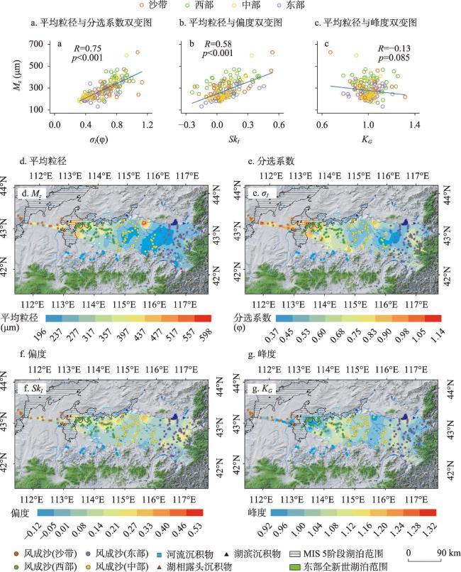
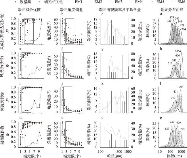
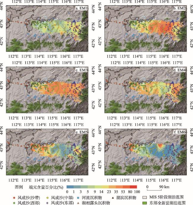
沙漠/沙地中沉积物的粒度是物源及各种地表过程长期作用的结果。研究沉积物粒度特征对认识沙漠/沙地形成演变和防沙治沙具有重要意义。本文对浑善达克沙地不同类型沉积物进行了详细采样,对其进行粒度和端元分析。结果表明,浑善达克沙地风成沙受风力分选作用影响,平均粒径和分选系数沿盛行风向存在显著变化趋势。偏度和峰度的空间格局较为复杂,可能与局地物源、沉积环境和植被覆盖等因素有关。端元分析结果显示,风成沙含有6个端元(EM),其中EM1与沙地西部湖相沉积露头有关;EM2来自松散的河湖相沉积物,在风力作用下呈现显著空间变化;EM3是风成沙的主要物质来源,与河流携带的碎屑物质有关;EM4可能来源于周围山体的冲洪积物;EM5和EM6粒度最粗,与间冰期河湖相沉积物中的粗粒组分相似。浑善达克沙地沉积物粒度特征表明,风成沙主要来自沙地附近不同时期的河湖相沉积物,远源贡献较少。沙地西部是风成沙的主要源区,在风力作用下较细组分的风成沙向沙地中东部运移,而沙地南缘和东缘河流也为其邻近区域贡献了沙源。本文研究说明,通过高密度采样并结合端元分析,沉积物粒度可解决地表过程复杂的沙漠地区风沙物源识别问题。
俞鑫晨 , 李鸿威 , 杨小平 , 刘子亭 , 张德国 , 任孝宗 . 浑善达克沙地沉积物粒度特征及其指示意义[J]. 地理学报, 2023 , 78(7) : 1809 -1824 . DOI: 10.11821/dlxb202307018
The grain size of sediments in sand seas is influenced by both sand provenance and various surface processes. This study collected 224 sedimentary samples from the Hunshandake Sandy Land including aeolian sand, fluvial and lacustrine sediments. Grain size measurement and end member analysis found that the mean grain size and sorting of aeolian sand generally decreased across the Hunshandake Sandy Land downwind in the SE direction. The spatial variations of skewness and kurtosis are more complex, indicating that the grain size parameters of aeolian sand are affected by the local provenance, depositional environment, and vegetation coverage. The end member analysis shows that the aeolian sand contains six end members (EM). EM1 is related to lacustrine outcrops in the western sandy land, while EM2 is likely to originate from loose fluvial and lacustrine sediments, controlled by both wind and topography. Fluvial deposits contribute to the widely distributed EM3, which is the dominant aeolian sand fraction found across the region. EM4 is predominantly found in the outer regions of the sand sea and closely associated with alluvial/fluvial deposits. EM5 and EM6 have the coarsest grain size and may originate from lacustrine/fluvial sediments that accumulated during past interglacials. Our findings suggest that the dune sand in Hunshandake mainly comes from the lacustrine/fluvial deposits around the sand sea, while the sand belt is unlikely to be a major source of dune sand. Aeolian sand with different sources is mixed in the western Hunshandake with fine fractions moved by the prevailing wind to the central and eastern parts of the sand sea. Rivers originating from the southern and eastern mountains also contribute aeolian sand to the adjacent areas. This study highlights the importance of extensive sampling combined with end member modeling for discriminating aeolian sand sources in desert areas.
Key words: aeolian sand; grain size; end member analysis; Hunshandake
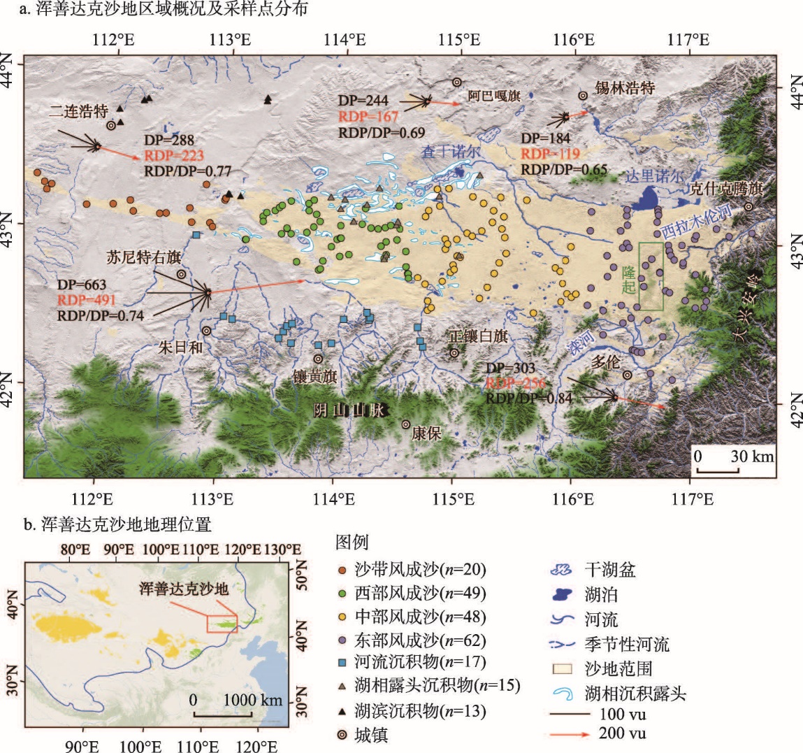
图1 浑善达克沙地地貌概况及采样点分布注:图a为1981—2010年沙地周边二连浩特、朱日和、阿巴嘎旗、锡林浩特和多伦气象站输沙势玫瑰图,输沙势玫瑰图根据Fryberger等[36]的方法进行计算;风况数据来源为 https://www.ncei.noaa.gov/access/search/data-search/global-hourly;图b中橙色区域为沙漠,绿色区域为沙地,蓝线为400 mm年等降水线。 Fig. 1 Map showing regional geology and sampling locations of the Hunshandake Sandy Land |
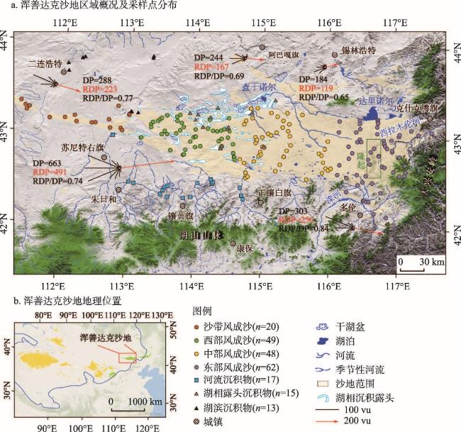
图2 浑善达克沙地气候与主要景观类型注:降水数据来自国家地球系统科学数据中心(http://www.geodata.cn);NDVI数据来自美国宇航局地球观测系统数据和信息系统(https://www.earthdata.nasa.gov);照片c、f、g由俞鑫晨于2020年9月拍摄,照片d由俞鑫晨于2022年8月拍摄,照片e和h由李鸿威分别于2011年9月和2020年9月拍摄。 Fig. 2 Regional settings and examples of landscapes found in the Hunshandake Sandy Land |
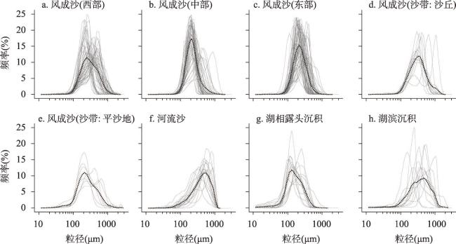
表1 浑善达克沙地沉积物粒径参数特征Tab. 1 Characteristics of sediment grain size parameters in the Hunshandake Sandy Land |
| 沉积物类型 | 采样位置 | 数量 | 统计参数 | 平均粒径Mz(μm) | 分选系数σI(φ) | 偏度SkI | 峰度KG |
|---|---|---|---|---|---|---|---|
| 风成沙 (沙带) | 沙丘 | 13 | 平均值 | 389 | 0.78 | 0.14 | 0.99 |
| 标准偏差 | 96 | 0.14 | 0.22 | 0.13 | |||
| 范围 | 265~625 | 0.58~1.07 | -0.21~0.54 | 0.67~1.20 | |||
| 平沙地 | 7 | 平均值 | 284 | 0.84 | 0.06 | 1.01 | |
| 标准偏差 | 69 | 0.23 | 0.15 | 0.15 | |||
| 范围 | 213~361 | 0.52~1.13 | -0.10~0.35 | 0.84~1.32 | |||
| 风成沙 (西部) | 沙丘 | 49 | 平均值 | 327 | 0.70 | 0.10 | 1.01 |
| 标准偏差 | 78 | 0.17 | 0.15 | 0.10 | |||
| 范围 | 190~471 | 0.39~1.01 | -0.24~0.41 | 0.79~1.25 | |||
| 风成沙 (中部) | 沙丘 | 48 | 平均值 | 251 | 0.52 | 0.06 | 1.00 |
| 标准偏差 | 74 | 0.15 | 0.09 | 0.04 | |||
| 范围 | 176~597 | 0.32~0.93 | -0.11~0.34 | 0.90~1.11 | |||
| 风成沙 (东部) | 沙丘 | 62 | 平均值 | 242 | 0.54 | 0.08 | 1.01 |
| 标准偏差 | 50 | 0.14 | 0.11 | 0.07 | |||
| 范围 | 132~384 | 0.36~0.88 | -0.15~0.46 | 0.79~1.14 | |||
| 河流 沉积物 | / | 17 | 平均值 | 433 | 0.84 | 0.22 | 1.04 |
| 标准偏差 | 108 | 0.18 | 0.13 | 0.10 | |||
| 范围 | 206~640 | 0.48~1.20 | 0.05~0.58 | 0.92~1.28 | |||
| 湖相 沉积物 | 湖相露头 沉积物 | 15 | 平均值 | 167 | 0.83 | 0.06 | 1.15 |
| 标准偏差 | 44 | 0.24 | 0.22 | 0.30 | |||
| 范围 | 112~257 | 0.43~1.25 | -0.35~0.54 | 0.92~1.93 | |||
| 湖滨 沉积物 | 13 | 平均值 | 407 | 0.79 | 0.11 | 1.13 | |
| 标准偏差 | 151 | 0.24 | 0.22 | 0.16 | |||
| 范围 | 158~670 | 0.44~1.40 | -0.33~0.50 | 0.79~1.34 |
:感谢Lydia Mackenzie在英文润色中给予的帮助。
| [1] |
UNEP. World Atlas of Desertification. 2nd ed. London: Edward Arnold, 1997.
|
| [2] |
IPCC. Climate Change and Land:IPCC Special Report on Climate Change, Desertification, Land Degradation, Sustainable Land Management, Food Security, and Greenhouse Gas Fluxes in Terrestrial Ecosystems. Cambridge: Cambridge University Press, 2022: 249-344.
|
| [3] |
|
| [4] |
|
| [5] |
|
| [6] |
[ 王涛. 我国沙漠化研究的若干问题: 2. 沙漠化的研究内容, 中国沙漠, 2003, 23(5): 477-482.]
|
| [7] |
[ 郭泽呈, 魏伟, 石培基, 等. 中国西北干旱区土地沙漠化敏感性时空格局. 地理学报, 2020, 75(9): 1948-1965.]
|
| [8] |
[ 徐志伟, 鹿化煜. 毛乌素沙地风沙环境变化研究的理论和新认识. 地理学报, 2021, 76(9): 2203-2223.]
|
| [9] |
[ 古拉依赛木·艾拜都拉, 张峰, 吴枫, 等. 腾格里沙漠沙丘沉积物粒度特征及其空间差异. 中国沙漠, 2022, 42(5): 133-145.]
|
| [10] |
|
| [11] |
[ 凌智永, 周亚辉, 李廷伟, 等. 东昆仑库木库里沙漠表层沉积物粒度特征、物源与沉积环境. 干旱区地理. 2017, 40(5): 1013-1019.]
|
| [12] |
[ 钱广强, 董治宝, 罗万银, 等. 巴丹吉林沙漠地表沉积物粒度特征及区域差异. 中国沙漠, 2011, 31(6): 1357-1364.]
|
| [13] |
[ 刘倩倩, 杨小平. 毛乌素沙地和库布齐沙漠风成沙粒度参数的空间变化及其成因. 中国沙漠, 2020, 40(5): 158-168.]
|
| [14] |
|
| [15] |
[ 宁凯, 李卓仑, 王乃昂, 等. 巴丹吉林沙漠地表风积砂粒度空间分布及其环境意义. 中国沙漠, 2013, 33(3): 642-648.]
|
| [16] |
|
| [17] |
[ 乌日查呼, 春喜, 张卫青, 等. 浑善达克沙地沙粒特征及其沉积环境. 西北林学院学报, 2021, 36(1): 69-76.]
|
| [18] |
|
| [19] |
|
| [20] |
|
| [21] |
|
| [22] |
[ 梁爱民, 屈建军, 董治宝, 等. 库姆塔格沙漠沉积物粒度端元特征及其物源启示. 中国沙漠, 2020, 40(2): 33-42.]
|
| [23] |
|
| [24] |
|
| [25] |
[ 樊杰. 中国主体功能区划方案. 地理学报, 2015, 70(2): 186-201.]
|
| [26] |
[ 高尚玉, 张春来, 邹学勇, 等. 京津风沙源治理工程效益. 2版. 北京: 科学出版社, 2012.]
|
| [27] |
[ 孙禹, 杜会石, 哈斯额尔敦, 等. 固定沙丘风蚀坑风沙动力学观测研究. 地理学报, 2016, 71(9): 1562-1570.]
|
| [28] |
[ 严恩萍, 林辉, 党永峰, 等. 2000—2012年京津风沙源治理区植被覆盖时空演变特征. 生态学报, 2014, 34(17): 5007-5020.]
|
| [29] |
|
| [30] |
|
| [31] |
[ 谢静, 吴福元, 丁仲礼. 浑善达克沙地的碎屑锆石U-Pb年龄和Hf同位素组成及其源区意义. 岩石学报, 2007, 23(2): 523-528.]
|
| [32] |
|
| [33] |
|
| [34] |
|
| [35] |
[ 朱震达, 吴正, 刘恕, 等. 中国沙漠概论. 北京: 科学出版社, 1980.]
|
| [36] |
|
| [37] |
|
| [38] |
|
| [39] |
|
| [40] |
|
| [41] |
|
| [42] |
|
| [43] |
|
| [44] |
|
| [45] |
|
| [46] |
|
| [47] |
|
| [48] |
|
| [49] |
[ 金秉福. 粒度分析中偏度系数的影响因素及其意义. 海洋科学, 2012, 36(2): 129-135.]
|
| [50] |
[ 卢连战, 史正涛. 沉积物粒度参数内涵及计算方法的解析. 环境科学与管理, 2010, 35(6): 54-60.]
|
| [51] |
|
| [52] |
|
| [53] |
|
| [54] |
|
/
| 〈 |
|
〉 |