
遥感数据产品率定水文模型的潜力研究
|
张永强(1976-), 男, 内蒙古包头人, 研究员, 博士生导师, 主要从事水文学与水资源研究。E-mail: zhangyq@igsnrr.ac.cn |
收稿日期: 2023-05-12
修回日期: 2023-06-30
网络出版日期: 2023-08-01
基金资助
国家重点研发计划(2022YFC3002804)
国家自然科学基金项目(41971032)
Potential of using remote sensing product to calibrate hydrological models
Received date: 2023-05-12
Revised date: 2023-06-30
Online published: 2023-08-01
Supported by
National Key R&D Program of China(2022YFC3002804)
National Natural Science Foundation of China(41971032)
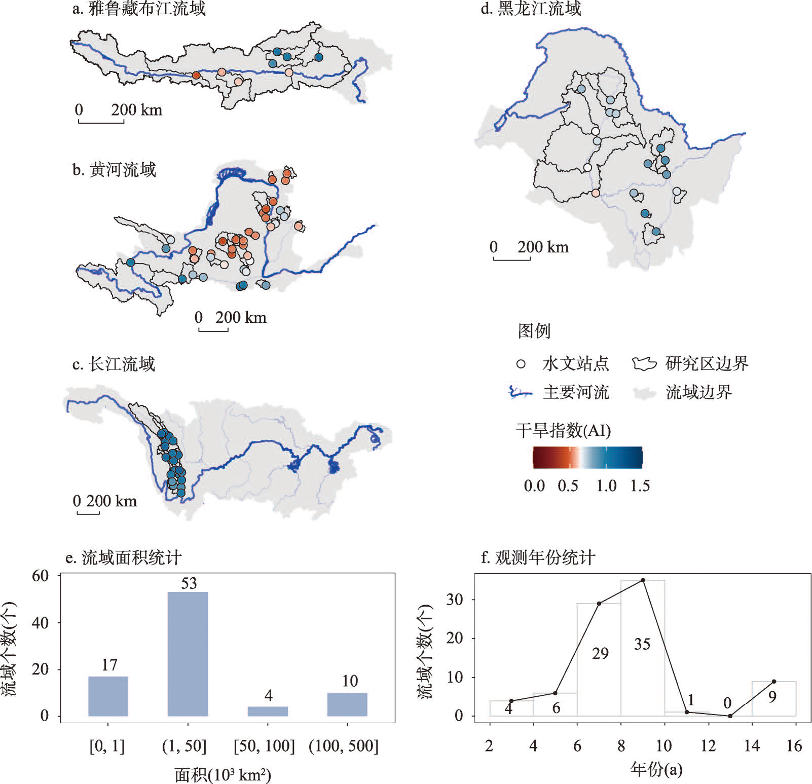
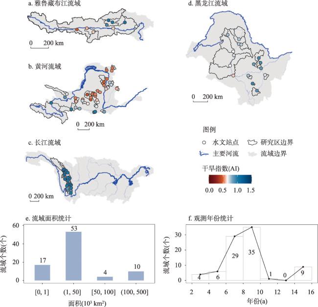
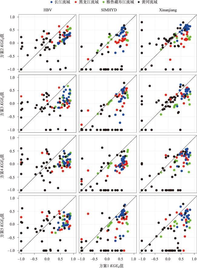
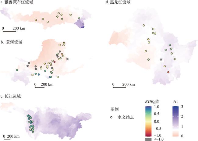
地表径流的预测和模拟是水文地理研究的核心,对水资源管理和规划都具有重要意义。传统研究借助于实测地表径流进行水文模型率定和参数移植,对“无测站流域”进行径流预测,但在实测径流稀缺或受到强人类活动(如大坝调控)干扰时,参数移植能力受到限制、预测能力不足。而遥感数据具有时空连续的优势,且不受制于地表径流观测时间序列,为径流预测提供了新思路。本文采用了遥感数据率定水文模型的方法,在中国84个流域探究该方法采用遥感蒸散发、水储量和土壤水数据不同组合率定水文模型,评估各方案预测流域径流的潜力。结果显示基于偏差校正后的网格蒸散发数据约束水文模型的新方法,在中国干旱区和湿润区均具有较大的应用潜力;在格网上约束水文模型相比集总式约束具有较为明显的优越性;应采用多个水文模型提升该方法在不同流域的应用潜力。该方法的径流预测能力具有明显的空间分异性,因地制宜方可有效发挥遥感数据的优势。
张永强 , 黄琦 , 刘昌明 , 杨永辉 . 遥感数据产品率定水文模型的潜力研究[J]. 地理学报, 2023 , 78(7) : 1677 -1690 . DOI: 10.11821/dlxb202307009
The prediction and estimation of surface runoff are core research topics in hydrology and geography, with important implications for water resource management and planning. Traditional research relies on measured surface runoff for model calibration and parameter transfer to predict runoff in ungauged basins. However, when measured runoff is scarce or disturbed by strong human activities (such as dam regulation), the ability of parameter transfer is limited, resulting in insufficient runoff prediction capacity. Remote sensing data, with its spatial and temporal continuity, and without being restricted by the observation time series of surface runoff, provides a new approach for runoff prediction. This article explores the method of calibrating hydrological models with remote sensing data in 84 basins in China. Different combinations of remote sensing evapotranspiration, water storage, and soil water data were used to evaluate the potential of predicting runoff by calibrating the hydrological models directly. The results showed that the new method of constraining hydrological models based on grid-based evapotranspiration data with bias correction has great potential for application in both arid and humid areas of China. Grid-based model constraint has a more obvious advantage over lumped model constraint, and multiple hydrological models should be used to enhance the application potential of this method in different basins. The runoff prediction capability and application potential of this method have spatial variability and should be tailored to local conditions to effectively leverage the advantages of remote sensing data.
表1 研究数据概况Tab. 1 Overview of the study data |
| 数据名称 | 全称 | 空间分辨率 | 时间分辨率 | 时间范围 | 数据链接 |
|---|---|---|---|---|---|
| MSWEP | MSWEP(V2.8) 多源加权融合 降水产品 | 0.1° | d | 1979— | http://www.gloh2o.org/mswep/ |
| MSWX | 多源气象数据 | 0.1° | d | 1979— | http://www.gloh2o.org/mswx/ |
| PML-V2(China) | 中国区域PML-V2 陆地蒸散发与总初级生产力数据集 | 500 m | d | 2000—2021 | https://DOI.org/10.11888/Terre.tpdc.272389 |
| GRACE | 重力卫星数据 | 1° | 月 | 2002—2017 | https://developers.google.com/earth-engine/datasets/catalog/NASA_GRACE_MASS_GRIDS_LAND |
| SMC | 中国土壤水数据 | 0.05° | 月 | 2002—2018 | https://DOI.org/10.5281/zenodo.4738556 |
| 日径流 | 中国84个水文站日资料 | - | d | 2000—2016 (各站点不同) | 水文年鉴、雅砻江水电开发有限公司 |
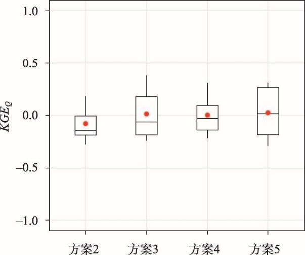
表2 不同方案日径流预测能力(KGEQ)汇总Tab. 2 Summary of runoff prediction ability (KGEQ) using different schemes |
| 方案2 | 方案3 | 方案4 | 方案5 | |
|---|---|---|---|---|
| 最大值 | 0.80 | 0.79 | 0.62 | 0.78 |
| 中值 | 0.13±2.01 | 0.07±2.46 | -0.01±4.48 | -0.03±3.37 |
注:中值数据为中位数±标准差。 |
表3 不同方案在不同流域应用不同水文模型的日径流预测能力(KGEQ)汇总Tab. 3 Summary of runoff prediction ability (KGEQ) using different hydrological models in different basins |
| 流域 | 方案 | HBV | SIMHYD | Xinanjiang |
|---|---|---|---|---|
| 黑龙江流域 | 方案2 | 0.29±0.52 | 0.09±0.53 | 0.14±0.61 |
| 方案3 | 0.06±0.21 | 0.29±0.38 | 0.34±0.55 | |
| 方案4 | -0.03±0.2 | -0.05±0.22 | 0.21±0.9 | |
| 方案5 | 0.12±0.26 | 0.14±0.41 | 0.19±1.11 | |
| 雅鲁藏布江流域 | 方案2 | 0.19±0.26 | 0.12±0.19 | 0.2±0.17 |
| 方案3 | 0.22±0.25 | 0.12±0.24 | -0.05±0.24 | |
| 方案4 | 0.13±0.17 | 0.02±0.3 | 0.02±0.22 | |
| 方案5 | 0.28±0.24 | 0.01±0.26 | 0.09±0.19 | |
| 长江流域 | 方案2 | 0.22±0.13 | 0.42±0.28 | 0.58±0.14 |
| 方案3 | 0.12±0.23 | 0.4±0.37 | 0.48±0.18 | |
| 方案4 | 0.08±0.16 | 0±0.16 | 0.36±0.21 | |
| 方案5 | 0.05±0.19 | 0.4±0.36 | 0.37±0.2 | |
| 黄河流域 | 方案2 | -0.11±1.29 | -1.69±3.95 | -0.01±1.11 |
| 方案3 | -0.17±2.02 | -2.04±4.66 | 0.05±1.7 | |
| 方案4 | -0.05±1.16 | -0.82±6.15 | -0.72±8.95 | |
| 方案5 | -0.16±2.15 | -1.7±3.84 | -1.17±6.41 |
注:表中数据为中位数±标准差。 |
| [1] |
|
| [2] |
|
| [3] |
|
| [4] |
[ 刘昌明, 白鹏, 王中根, 等. 稀缺资料流域水文计算若干研究: 以青藏高原为例. 水利学报, 2016, 47(3): 272-282. ]
|
| [5] |
[ 刘苏峡, 刘昌明, 赵卫民. 无测站流域水文预测(PUB)的研究方法. 地理科学进展, 2010, 29(11): 1333-1339.
|
| [6] |
[ 于瑞宏, 张宇瑾, 张笑欣, 等. 无测站流域径流预测区域化方法研究进展. 水利学报, 2016, 47(12): 1528-1539.]
|
| [7] |
|
| [8] |
[ 李红霞, 张新华, 张永强, 等. 缺资料流域水文模型参数区域化研究进展. 水文, 2011, 31(3): 13-17.]
|
| [9] |
|
| [10] |
|
| [11] |
|
| [12] |
|
| [13] |
|
| [14] |
|
| [15] |
|
| [16] |
|
| [17] |
|
| [18] |
|
| [19] |
|
| [20] |
|
| [21] |
|
| [22] |
|
| [23] |
[ 吴勇. MSWEP降水数据在元江流域的精度检验与水文模拟效果评估[D]. 昆明: 云南大学, 2019.]
|
| [24] |
[ 许昕彤, 朱丽, 吕潇雨, 等. MSWEP降水产品在黄河流域气象干旱监测中的适用性评价. 干旱区地理, 2023, 46(3): 371-384.]
|
| [25] |
[ 邓越, 蒋卫国, 王晓雅, 等. MSWEP降水产品在中国大陆区域的精度评估. 水科学进展, 2018, 29(4): 455-464.]
|
| [26] |
[ 黄琦, 覃光华, 王瑞敏, 等. 基于MSWEP的祁连山地区降水空间分布特性解析. 水利学报, 2020, 51(2): 232-244.]
|
| [27] |
|
| [28] |
|
| [29] |
|
| [30] |
|
| [31] |
[ 傅抱璞. 论陆面蒸发的计算. 大气科学, 1981, 5(1): 23-31.]
|
| [32] |
|
| [33] |
|
| [34] |
|
| [35] |
|
| [36] |
|
| [37] |
|
| [38] |
|
| [39] |
|
| [40] |
|
| [41] |
[ 刘剑宇, 张强, 陈喜, 等. 气候变化和人类活动对中国地表水文过程影响定量研究. 地理学报, 2016, 71(11): 1875-1885.]
|
| [42] |
[ 杨大文, 李翀, 倪广恒, 等. 分布式水文模型在黄河流域的应用. 地理学报, 2004, 59(1): 143-154.]
|
/
| 〈 |
|
〉 |
