
太湖平原地区洪水特征变化及驱动机理
|
王强(1992-), 男, 安徽安庆人, 助理研究员, 主要从事城市化地区水文观测与模拟研究。E-mail: wqianghy@nju.edu.cn |
收稿日期: 2022-06-20
修回日期: 2023-03-28
网络出版日期: 2023-05-27
基金资助
国家自然科学基金项目(42101020)
国家自然科学基金项目(U2240203)
中国博士后科学基金项目(2021M691529)
江苏省博士后科研资助计划(2021K121B)
Changes in flood characteristics and their driving mechanisms in the Taihu Plain region
Received date: 2022-06-20
Revised date: 2023-03-28
Online published: 2023-05-27
Supported by
National Natural Science Foundation of China(42101020)
National Natural Science Foundation of China(U2240203)
China Postdoctoral Science Foundation(2021M691529)
Jiangsu Postdoctoral Research Funding Program(2021K121B)
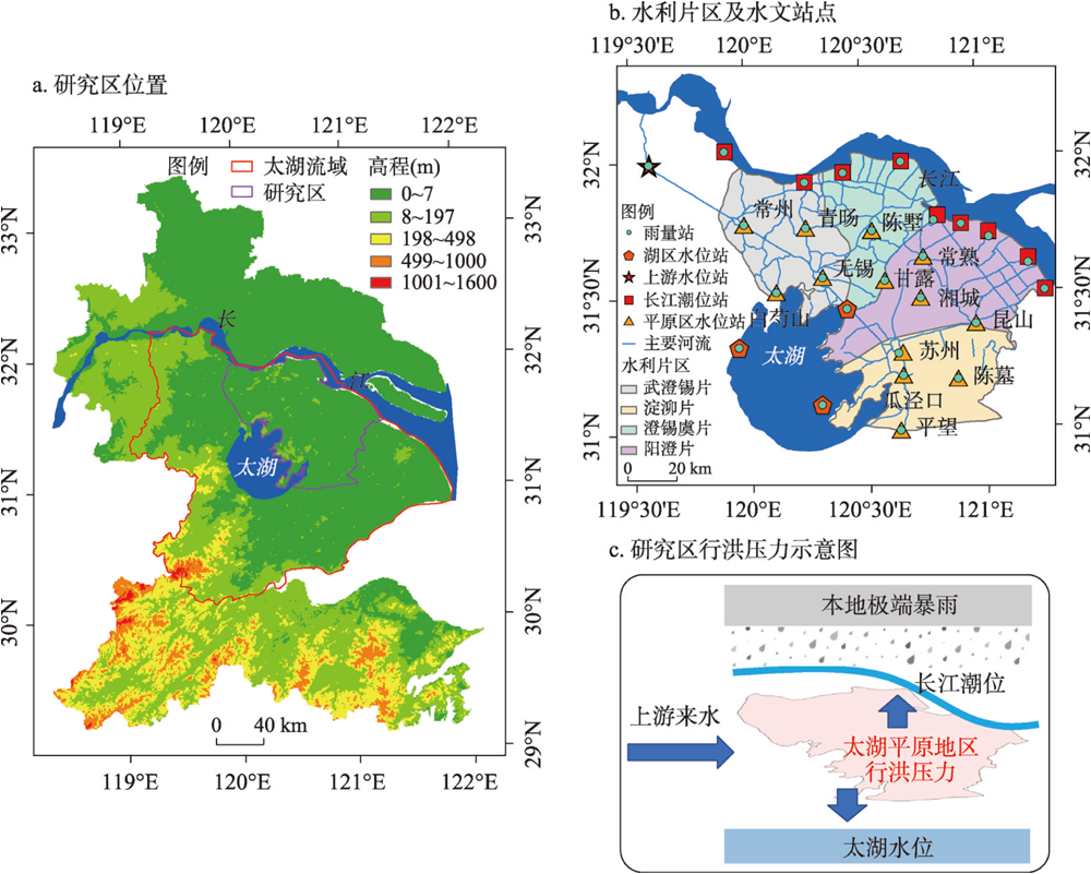
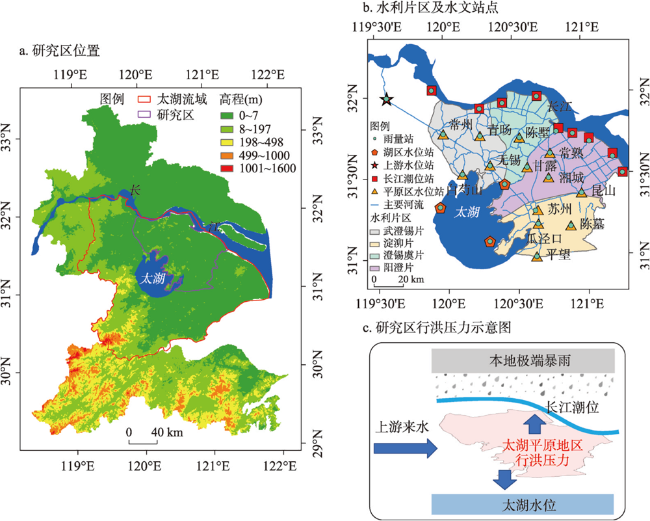
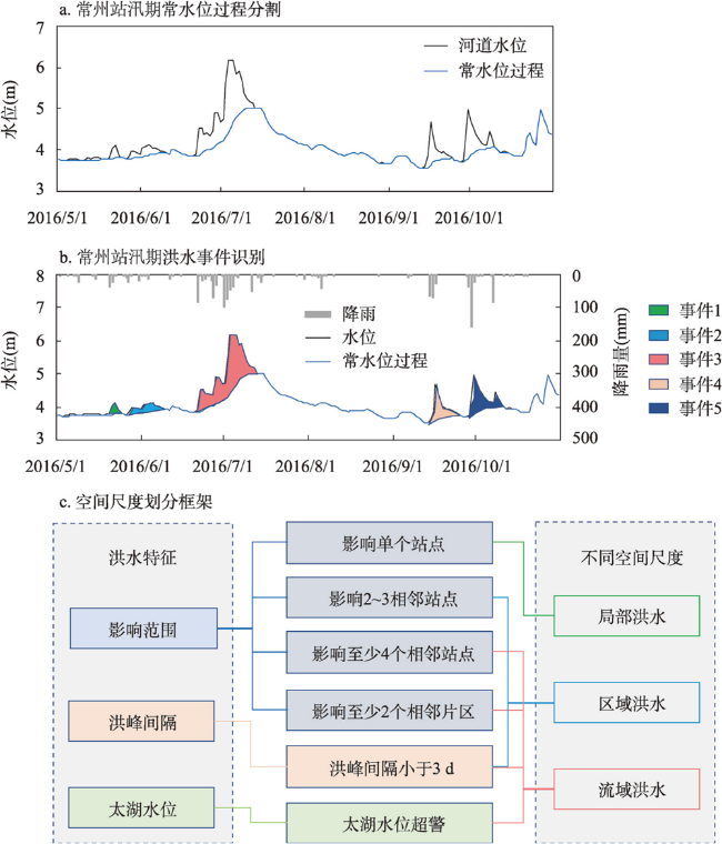
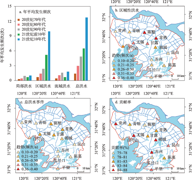
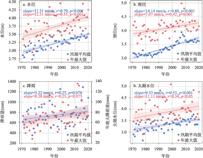
城市化及气候变化影响下洪水问题日益突出,其有从单点向多点、局部向区域、城区向郊区转移的趋势,传统洪水演变规律研究多关注量级变化,对于变化环境下洪水空间尺度特征与影响范围变化的认识尚不清晰。本文以太湖平原地区为典型,建立了基于过程的平原河网地区洪水事件识别与尺度划分方法,分析了1971—2020年局部、区域、和流域不同尺度洪水的特征及变化规律。结果表明,太湖平原地区洪水事件表现出明显的空间尺度差异,以区域性洪水为主(占比69.34%),其中特大洪水主要为流域和区域性洪水。近50年来研究区洪水频次呈现显著增加趋势,主要是由于区域性洪水增加(贡献率为80.8%)。太湖平原地区洪涝成因复杂,不同尺度洪水特征与降雨、潮位、太湖水位、上游来水等因素多表现为显著性相关关系。前期水位是局部和区域性洪水主要驱动因素(贡献率分别占53.2%和54.98%);总降雨量对局部、区域和流域性洪水的洪水涨幅起主导作用,相对贡献率分别为64.91%、65.01%和78.72%。不同尺度洪水特征的主要驱动因素及其影响程度存在一定空间差异。变化环境背景下太湖平原地区不仅洪水频次和量级有所增加,同时洪水空间尺度也发生了显著变化。本文研究结果可为太湖平原及类似河口三角洲地区不同尺度洪水识别及其形成与驱动机理分析提供参考,保障变化环境下区域防洪安全。
王强 , 许有鹏 , 杨龙 , 童建 , 林芷欣 , 高斌 . 太湖平原地区洪水特征变化及驱动机理[J]. 地理学报, 2023 , 78(5) : 1088 -1103 . DOI: 10.11821/dlxb202305003
Under the background of urbanization and climate change, flood disasters are getting more and more serious. Floods tend to shift from single site to multi-sites and from urban area to suburb area, however, the mechanism of flood formation and transformation at different scales under changing environment is still unclear. In this study, we proposed a process-based flood event identification and scale division method. We then detected the characteristics, changes and driving mechanisms of local, regional and basin-scale floods at the Taihu Plain region during the past 50 years (1971-2020). The results indicate that floods in the study area showed distinct scales, with regional floods dominated (69.34%), and extraordinary floods were at basin sclae or regional scale. Floods in the study area showed a significant increase trend, mainly due to the increase of regional floods (accounting for 80.8%) in 1971-2020. Flood characteristics at different scales are significantly correlated with rainfall, tidal level, water level of the Taihu Lake, and upstream water amount. The antecedent conditions of water level were the main driving factor of local and regional floods (contributing 53.2% and 54.98%, respectively). Total rainfall played a dominant role in the rise of water level for local, regional and basin-scale floods, with the relative contributions of 64.91%, 65.01% and 78.72%, respectively. The main driving factors of flood characteristics at different scales and their influencing degree also have some spatial differences. The results of this study show that the spatial scale of floods has changed significantly under the background of changing environment in the Taihu Plain region, which would provide a feasible idea and reference for the identification of floods and mechanism analysis of its changes at different scales in this region or a similar estuary deltas area. This can help to ensure the regional flood control safety under the changing environment.
Key words: floods; scale features; influencing factors; random forest; Taihu Plain region
表1 平原河网地区洪水事件及其驱动因素特征指标Tab. 1 The characteristic index of flood events and its driving factors in plain regions |
| 水文特征要素 | 指标 | 简写 | 单位 |
|---|---|---|---|
| 降雨 | 总降雨量 | RA | mm |
| 平均降雨强度 | RI | mm/d | |
| 最大降雨强度 | RM | mm/d | |
| 降雨持续时间 | RD | d | |
| 前期(7 d)降雨 | R7 | mm | |
| 潮位 | 起始潮位 | CI | m |
| 最高潮位 | CM | m | |
| 平均潮位 | CA | m | |
| 上游水位 | 上游起始水位 | m | |
| 上游最高水位 | m | ||
| 上游平均水位 | m | ||
| 太湖水位 | 起始太湖水位 | m | |
| 太湖最高水位 | m | ||
| 太湖平均水位 | m | ||
| 洪水 | 起始水位 | m | |
| 洪峰水位 | m | ||
| 洪水涨幅 | m | ||
| 涨水速率 | m/d | ||
| 退水速率 | m/d |
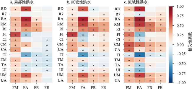
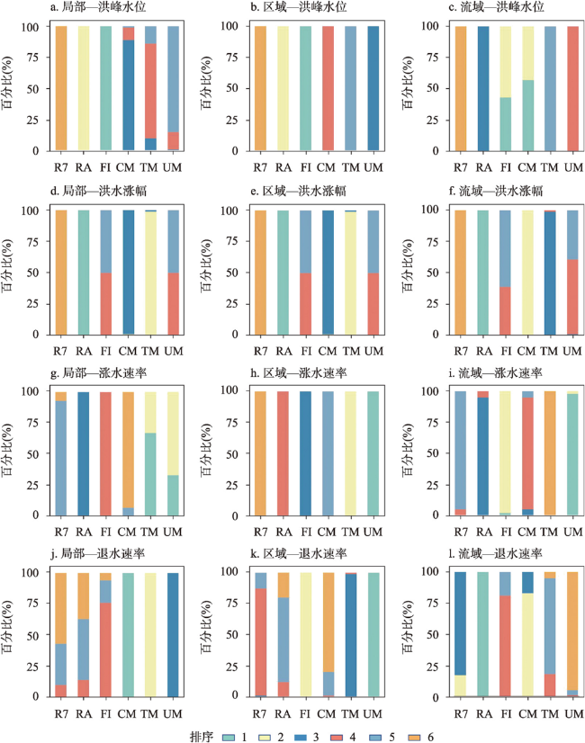
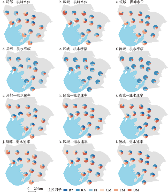
图6 不同空间尺度洪水特征指标的影响因素排序Fig. 6 The importance ranking of influencing factors for flood characteristics at different spatial scales |
表2 不同尺度洪水特征受主控因子影响的相对贡献率(%)Tab. 2 The relative contributions of influencing factors for flood characteristics at different spatial scales (%) |
| 不同尺度 | 洪水特征 | R7 | RA | FI | CM | TM | UM |
|---|---|---|---|---|---|---|---|
| 局部洪水 | 洪峰水位 | 1.95 | 22.88 | 53.20 | 8.31 | 7.19 | 6.46 |
| 洪水涨幅 | 4.19 | 64.91 | 6.11 | 8.48 | 10.19 | 6.13 | |
| 涨水速率 | 9.70 | 16.06 | 12.72 | 8.65 | 27.03 | 25.84 | |
| 退水速率 | 3.85 | 4.00 | 4.98 | 41.54 | 30.34 | 15.28 | |
| 区域洪水 | 洪峰水位 | 2.22 | 21.45 | 54.98 | 5.15 | 4.22 | 11.98 |
| 洪水涨幅 | 3.89 | 65.01 | 6.09 | 7.69 | 7.72 | 9.59 | |
| 涨水速率 | 10.07 | 15.98 | 17.48 | 12.22 | 19.38 | 24.87 | |
| 退水速率 | 13.60 | 12.68 | 21.25 | 11.82 | 16.59 | 24.05 | |
| 流域洪水 | 洪峰水位 | 2.49 | 17.91 | 33.61 | 34.04 | 5.00 | 6.94 |
| 洪水涨幅 | 2.85 | 78.72 | 3.70 | 6.71 | 4.30 | 3.73 | |
| 涨水速率 | 11.84 | 15.15 | 25.13 | 13.64 | 7.31 | 26.93 | |
| 退水速率 | 17.47 | 21.79 | 14.85 | 18.39 | 14.42 | 13.08 |
| [1] |
[ 张建云, 宋晓猛, 王国庆, 等. 变化环境下城市水文学的发展与挑战: I.城市水文效应. 水科学进展, 2014, 25(4): 594-605.]
|
| [2] |
[ 杨大文, 徐宗学, 李哲, 等. 水文学研究进展与展望. 地理科学进展, 2018, 37(1): 36-45.]
|
| [3] |
[ 徐宗学, 程涛. 城市水管理与海绵城市建设之理论基础: 城市水文学研究进展. 水利学报, 2019, 50(1): 53-61.]
|
| [4] |
[ 刘家宏, 王浩, 高学睿, 等. 城市水文学研究综述. 科学通报, 2014, 59(36): 3581-3590.]
|
| [5] |
[ 刘昌明, 郑度, 崔鹏, 等. 自然地理学创新发展与展望. 地理学报, 2020, 75(12): 2547-2569.]
|
| [6] |
|
| [7] |
[ 张建云, 王银堂, 贺瑞敏, 等. 中国城市洪涝问题及成因分析. 水科学进展, 2016, 27(4): 485-491.]
|
| [8] |
|
| [9] |
|
| [10] |
[ 李建柱, 冯平. 降雨因素对大清河流域洪水径流变化影响分析. 水利学报, 2010, 41(5): 595-600.]
|
| [11] |
[ 史培军, 袁艺, 陈晋. 深圳市土地利用变化对流域径流的影响. 生态学报, 2001, 21(7): 1041-1049.]
|
| [12] |
|
| [13] |
[ 王跃峰, 许有鹏, 张倩玉, 等. 太湖平原区河网结构变化对调蓄能力的影响. 地理学报, 2016, 71(3): 449-458.]
|
| [14] |
[ 王跃峰. 城市化地区圩垸防洪影响下的暴雨洪水演变与洪涝风险变化研究: 以太湖平原武澄锡虞区为例[D]. 南京: 南京大学, 2019.]
|
| [15] |
[ 王丹青, 许有鹏, 王思远, 等. 城镇化背景下平原河网区暴雨洪水重现期变化分析: 以太湖流域武澄锡虞区为例. 水利水运工程学报, 2019(5): 27-35.]
|
| [16] |
|
| [17] |
|
| [18] |
|
| [19] |
|
| [20] |
|
| [21] |
|
| [22] |
|
| [23] |
|
| [24] |
|
| [25] |
|
| [26] |
|
| [27] |
|
| [28] |
[ 周星, 沈忱, 倪广恒, 等. 结合退水曲线的数字滤波基流分割方法. 清华大学学报: 自然科学版, 2017, 57(3): 318-323, 330.]
|
| [29] |
[ 林荷娟, 程媛华, 梅青, 等. 太湖警戒水位研究. 中国水利, 2014(7): 55-57.]
|
| [30] |
[ 吴浩云, 王银堂, 胡庆芳, 等. 太湖流域洪水识别与洪水资源利用约束分析. 水利水运工程学报, 2016(5): 1-8.]
|
| [31] |
[ 许有鹏. 长江三角洲地区城市化对流域水系与水文过程的影响. 北京: 科学出版社, 2012: 101-118.]
|
| [32] |
[ 尹义星, 许有鹏, 陈莹. 太湖流域典型区50年代以来极值水位时空变化. 地理研究, 2011, 30(6): 1077-1088.]
|
| [33] |
[ 黄国如, 张瀚. 气候变化对广州市城市雨潮遭遇风险的影响评估. 华北水利水电大学学报: 自然科学版, 2016, 37(5): 7-15.]
|
| [34] |
[ 涂新军, 杜奕良, 陈晓宏, 等. 滨海城市雨潮遭遇联合分布模拟与设计. 水科学进展, 2017, 28(1): 49-58.]
|
| [35] |
[ 袁雯, 杨凯, 唐敏, 等. 平原河网地区河流结构特征及其对调蓄能力的影响. 地理研究, 2005, 24(5): 717-724.]
|
| [36] |
|
| [37] |
|
/
| 〈 |
|
〉 |
