
全球海底光缆网络空间格局与战略支点及通道的识别
|
谢永顺(1994-), 男, 河北石家庄人, 博士, 主要从事交通地理与区域发展研究。E-mail: ysxiee@163.com |
收稿日期: 2021-10-15
修回日期: 2022-07-17
网络出版日期: 2023-02-16
基金资助
国家自然科学基金项目(42071151)
中国科学院战略性先导科技专项(XDA20010101)
Spatial pattern of global submarine cable network and identification of strategic pivot and strategic channel
Received date: 2021-10-15
Revised date: 2022-07-17
Online published: 2023-02-16
Supported by
National Natural Science Foundation of China(42071151)
Strategic Priority Research Program of the Chinese Academy of Sciences(XDA20010101)
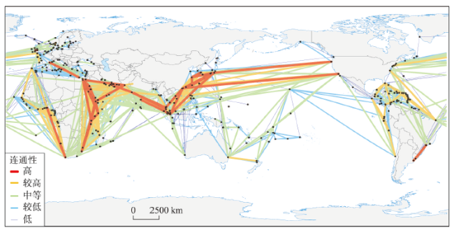
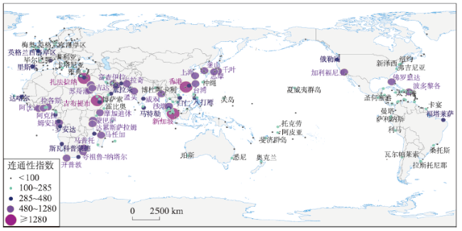
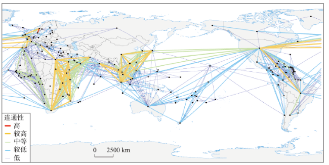
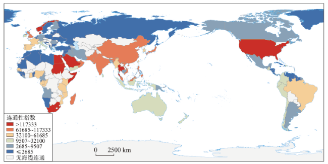
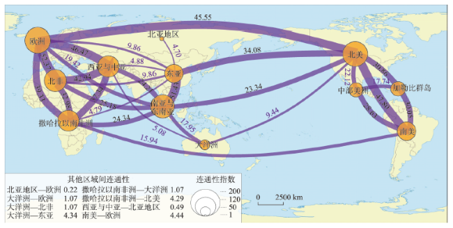
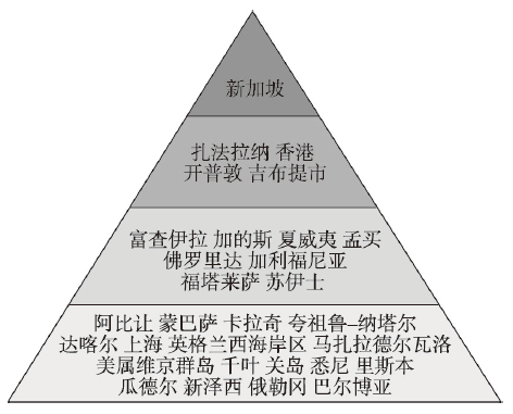
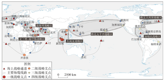
海底光缆作为大型连通性基础设施,在国际电信、社会经济乃至国防安全等领域发挥着至关重要的作用,但当前对全球海底光缆网络空间格局的了解相对有限。基于此,本文对全球海底光缆的分布格局、连通格局进行分析,并对其战略支点、战略通道进行识别。结果表明:① 全球海底光缆的空间分布具有显著非均衡性,海缆线路与海上航线极为相似,登陆站点沿海岸线不均匀地集聚分布。② 全球海底光缆网络的连通格局具有显著的尺度累加效应,在微观、中观、宏观视角下连通结构分别呈链式、组团式和轴辐式。③ 全球海底光缆网络的战略支点和战略通道呈金字塔式等级结构,新加坡的战略支点地位和亚丁湾、马六甲海峡的战略通道地位最高。在此基础上可进一步划分出6个战略区域,其战略意义和安全风险各异,需要给予特别关注和警惕。
谢永顺 , 王成金 . 全球海底光缆网络空间格局与战略支点及通道的识别[J]. 地理学报, 2023 , 78(2) : 386 -402 . DOI: 10.11821/dlxb202302008
As a kind of large-scale connectivity infrastructure, submarine cables play a vital role in international telecommunication, socio-economic development, and national defense and security. However, the current understanding about the spatial pattern of global submarine optical cable network is relatively limited. In this article, we analyze the spatial distribution and connectivity pattern of global submarine cables, and identify their strategic pivots and strategic channels. The main conclusions are as follows: (1) The spatial distribution of global submarine cables is significantly unbalanced, which is characterized by the facts that the distribution of submarine cable lines is similar to that of sea lanes, and the agglomerations of landing stations are distributed unevenly along the coastline. (2) The connectivity pattern of global submarine cable network has a significant scale effect. At the micro, meso and macro scales, the connectivity structure presents chain model, cluster model and hub-and-spoke model, respectively. (3) The distribution of strategic pivots and strategic channels shows a pyramidal hierarchical feature. Singapore ranks highest among all the strategic pivots, while the Gulf of Aden and the Strait of Malacca rank highest among the strategic channels. Based on the identification of strategic pivots and channels, 6 strategic regions have been divided, which face various network security risks and need special attention and vigilance.
表1 全球海底光缆网络战略通道等级结构Tab. 1 Hierarchical structure of strategic channels of global submarine cable network |
| 战略通道等级 | 序号 | 海域名称 | 平均路径长度 | 网络效率 | 平均度 | 孤立节点比例 | 平均变 化率 | |||
|---|---|---|---|---|---|---|---|---|---|---|
| 值 | 变化率 | 值 | 变化率 | 值 | 变化率 | |||||
| 一级 | 1 | 亚丁湾 | 4.680 | 0.063 | 0.018 | 0.143 | 6.183 | 0.137 | 0.034 | 0.377 |
| 2 | 马六甲海峡 | 4.887 | 0.110 | 0.019 | 0.095 | 6.391 | 0.108 | 0.051 | 0.365 | |
| 二级 | 3 | 中国南海 | 4.612 | 0.048 | 0.019 | 0.095 | 6.295 | 0.121 | 0.040 | 0.304 |
| 4 | 红海 | 4.589 | 0.043 | 0.019 | 0.095 | 6.308 | 0.119 | 0.037 | 0.295 | |
| 5 | 加勒比海 | 4.597 | 0.045 | 0.019 | 0.095 | 6.419 | 0.104 | 0.040 | 0.284 | |
| 三级 | 6 | 新加坡海峡 | 4.830 | 0.097 | 0.019 | 0.095 | 6.608 | 0.078 | 0.040 | 0.263 |
| 7 | 阿拉伯海 | 4.500 | 0.022 | 0.019 | 0.095 | 6.395 | 0.107 | 0.031 | 0.256 | |
| 8 | 阿曼湾 | 4.483 | 0.019 | 0.019 | 0.095 | 6.454 | 0.099 | 0.040 | 0.253 | |
| 9 | 地中海—东部盆地 | 4.583 | 0.041 | 0.020 | 0.048 | 6.452 | 0.099 | 0.057 | 0.245 | |
| 10 | 直布罗陀海峡 | 4.824 | 0.096 | 0.020 | 0.048 | 6.901 | 0.037 | 0.026 | 0.206 | |
| 四级 | 11 | 南太平洋 | 4.472 | 0.016 | 0.020 | 0.048 | 6.649 | 0.072 | 0.051 | 0.187 |
| 12 | 印度洋 | 4.743 | 0.078 | 0.020 | 0.048 | 6.926 | 0.033 | 0.026 | 0.184 | |
| 13 | 凯尔特海 | 4.642 | 0.055 | 0.020 | 0.048 | 6.810 | 0.049 | 0.031 | 0.183 | |
| 14 | 北大西洋 | 4.606 | 0.047 | 0.020 | 0.048 | 6.805 | 0.050 | 0.031 | 0.176 | |
| 15 | 苏伊士湾 | 4.557 | 0.035 | 0.020 | 0.048 | 6.706 | 0.064 | 0.029 | 0.175 | |
| 16 | 北太平洋 | 4.589 | 0.043 | 0.020 | 0.048 | 6.845 | 0.044 | 0.026 | 0.160 | |
| 17 | 南大西洋 | 4.577 | 0.040 | 0.020 | 0.048 | 6.869 | 0.041 | 0.029 | 0.157 | |
| 18 | 菲律宾海 | 4.495 | 0.021 | 0.021 | 0.000 | 6.904 | 0.036 | 0.026 | 0.083 | |
| [1] |
|
| [2] |
|
| [3] |
[ 叶银灿. 海底光缆工程发展20年. 海洋学研究, 2006, 24(3): 1-10.]
|
| [4] |
|
| [5] |
|
| [6] |
|
| [7] |
|
| [8] |
|
| [9] |
[ 章卓凡, 张维阳, 翟庆华, 等. 全球海底光缆传输网络的节点职能与鲁棒性评价. 世界地理研究, 2022, 31(5): 929-940.]
|
| [10] |
|
| [11] |
|
| [12] |
[ 刘晴. 美国互联网企业参与海底光缆修建动因分析. 保密科学技术, 2019(10): 59-62.]
|
| [13] |
|
| [14] |
Mitchell L Moss A M T. The Internet backbone and the American metropolis. The Information Society, 2000, 16(1): 35-47.
|
| [15] |
|
| [16] |
|
| [17] |
|
| [18] |
|
| [19] |
|
| [20] |
|
| [21] |
|
| [22] |
|
| [23] |
|
| [24] |
|
| [25] |
|
| [26] |
|
| [27] |
|
| [28] |
|
| [29] |
|
| [30] |
|
| [31] |
|
| [32] |
|
| [33] |
[ 巴凯斯, 路紫. 从地理空间到地理网络空间的变化趋势: 兼论西方学者关于电信对地区影响的研究. 地理学报, 2000, 55(1): 104-111.]
|
| [34] |
[ 孙中伟, 路紫, 贺军亮. 世界互联网信息流的空间格局及其组织机理. 人文地理, 2009, 24(4): 43-49.]
|
| [35] |
[ 孙中伟, 王杨. 中国信息与通信地理学研究进展与展望. 地理科学进展, 2011, 30(2): 149-156.]
|
| [36] |
|
| [37] |
[ 叶银灿, 姜新民, 潘国富. 海底光缆工程. 北京: 海洋出版社, 2015: 71-74.]
|
| [38] |
|
/
| 〈 |
|
〉 |


