
第一次世界大战初期德国东亚驻军跨岛链作战的军事地理分析
|
杨霄(1988-), 男, 山东青岛人, 博士, 青年副研究员, 中国地理学会会员(S110009064M), 主要从事历史地理研究。E-mail: yangx0607@126.com |
收稿日期: 2022-05-30
修回日期: 2022-12-21
网络出版日期: 2023-01-16
基金资助
国家社会科学基金重大项目(15ZDB039)
An investigation of the German naval operations across the island chain around China at the beginning of World War I
Received date: 2022-05-30
Revised date: 2022-12-21
Online published: 2023-01-16
Supported by
Major Project of National Social Science Foundation of China(15ZDB039)
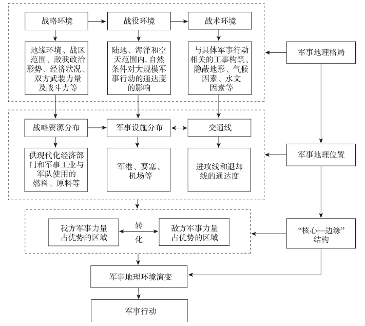
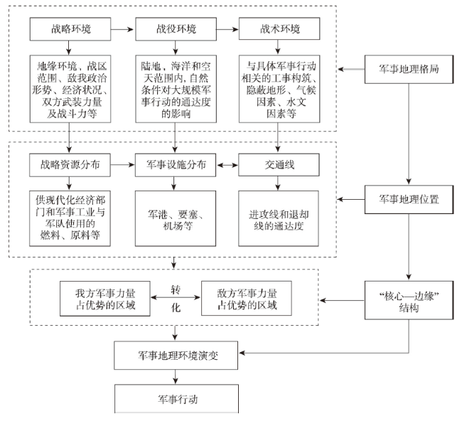
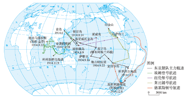
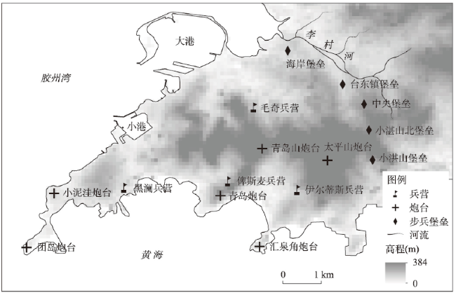
就军事地理环境而言,当代中国在海洋方向面临的最主要威胁来自环中国岛链的封锁,研究这一限制性地理环境对准备和实施军事活动的影响与相应对策,具有重要的现实意义。第一次世界大战(简称“一战”)初期,德国东亚驻军进行了跨岛链作战的实践,但在日本海军依托岛链和优势兵力的封锁下,其战略目标未能达成,并且出现了军事地理位置上的优劣转换。本文通过对“一战”初期德国东亚驻军跨岛链作战行动的军事地理分析,尝试提出军事地理研究思路、跨学科融合路径和分析框架。本文分析认为,彼时德占青岛虽然具有良好的战略态势和强大的军事力量,但孤悬海外,且缺乏战略纵深;从宏观的区域尺度分析来看,基地与舰队间的联系被岛链分隔,腹背受敌,军事地理上的劣势凸显。但依托岛链进行封锁,需要集结大量兵力,利用对方边缘区内作战力量相对比较薄弱的有利条件,原本实力较弱的德国东亚舰队取得了重大战果,形成反转式的“核心—边缘”结构。本文为中国的海疆安全和海洋强国建设提出了5条建议。
杨霄 . 第一次世界大战初期德国东亚驻军跨岛链作战的军事地理分析[J]. 地理学报, 2023 , 78(1) : 230 -240 . DOI: 10.11821/dlxb202301015
In terms of military geographical environment, the severest threat for the marine security of contemporary China comes from the blockade of the island chains around the country's coastline built by the United States and its allies. It is of obvious practical significance for war preparedness and national defense to study the comprehensive influences of this special geographical environment. This paper focuses on this practical problem and tries to reveal the complex and dynamic relationship between military geography environment and wars and thus proposes a research approach and analytical framework for military geography study from an interdisciplinary perspective integrating history, geography and military science. This process is further illustrated based on the analysis of a specific war case: The German naval operations across the island chain around China at the early stage of the World War I. At the early stage of World War I, German troops in East Asia tried to conduct cross-island chain warfare, but soon defeated by the superior forces of Japanese navy and its blockade relying on island chains. This process had led to a transformation of military geographical position to both sides of this military operation. This paper elaborates this transformation applying the theory of "core-periphery" structure: As a seaport under German occupation, Qingdao had advantageous strategic location and military strength. But it was relatively geographic isolated and lacked strategic depth. From the perspective of macro region, Qingdao as a German navy base was separated with its fleet by island chains built by its enemy, making it easily attacked from both front and rear. On the other hand, it required a large number of troops for Japanese army to carry out the blockade, leading to the weakening of the forces in its border areas. It is precisely in this weakened area that the German East Asia Fleet, which was originally at a disadvantage, found new opportunity and made significant achievement. Thereby, the previous military structure of "core-periphery" was dramatically reversed, forming a new military geographical situation. Finally, this paper put forward five suggestions for the study of maritime security and the construction of China's maritime power.
表1 环中国岛链及其附近主要海峡与水道Tab. 1 Island chain around China and main straits and waterways nearby |
| 名称 | 位置 | 宽度(km) | 水深(m) |
|---|---|---|---|
| 宗谷海峡 | 北海道最北端与库页岛最南端之间 | 42 | 30~67 |
| 津轻海峡 | 北海道与本州之间 | 20~50 | 200 |
| 朝鲜海峡 | 朝鲜半岛东南部与本州岛和九州岛之间 | 180 | 50~150 |
| 对马海峡 | 对马岛与九州岛之间 | >46 | 92~129 |
| 大隅海峡 | 九州岛南端 | 28 | 80~200 |
| 吐噶喇海峡 | 日久良布岛、屋久岛与口之岛之间 | 43 | 400~600 |
| 大岛海峡 | 奄美大岛与加计吕麻岛之间 | 1~22 | 30~100 |
| 口之岛水道 | 口之岛与中之岛之间 | 9 | 200~500 |
| 中之岛水道 | 中之岛与诹访濑岛之间 | 19 | 500~700 |
| 诹访濑水道 | 诹访濑岛恶石岛之间 | 17 | 600~900 |
| 德之北水道 | 奄美群岛中部 | 22 | 150~500 |
| 冲奄海峡 | 冲绳岛与奄美大岛之间 | >9 | 200~600 |
| 德之南水道 | 德之岛与冲水良部岛之间 | 33 | 350~600 |
| 宫古海峡 | 冲绳岛与宫古岛之间 | 269 | 500~1500 |
| 古垣海峡 | 宫古岛与石垣岛之间 | 48 | 70~500 |
| 与那国东水道 | 与那国岛与西表岛之间 | 65 | 200~1000 |
| 台湾海峡 | 台湾岛与福建之间 | 130~200 | 60~80 |
| 巴士海峡 | 台湾岛与巴坦群岛之间 | 94~185 | 2200~5126 |
注:数据来源:刘宝银, 杨晓梅. 环中国岛链: 海洋地理、军事区位、信息系统. 北京: 海洋出版社, 2003: 6-7. |
本文在收集资料的过程中得到海德堡大学刘峰博士的帮助,匿名专家提出了宝贵的修改意见,在此表示衷心的感谢。
| [1] |
[ 冯配岳, 沈伟烈. 关于军事地理学几个问题的探讨. 地理科学, 1984, 4(2): 183-187.]
|
| [2] |
[ 刘建忠. 对军事地理学学科体系构成的认识. 解放军测绘学院学报, 1993, 10(1): 62-65.]
|
| [3] |
[ 黄平. 现代军事地理学的科学化和理论化. 解放军测绘学院学报, 1992, 9(2): 64-68.]
|
| [4] |
[ 刘思和. 军事地理学研究之我见. 地域研究与开发, 1989, 8(2): 55-57.]
|
| [5] |
[ 潘忠岐, 黄仁伟. 中国的地缘政治与安全战略. 社会科学, 2011(10): 4-11.]
|
| [6] |
[ 史春林, 李秀英. 美国岛链封锁及其对我国海上安全的影响. 世界地理研究, 2013, 22(2): 1-10.]
|
| [7] |
[ 杜德斌, 马亚华, 范斐, 等. 中国海上通道安全及保障思路研究. 世界地理研究, 2015, 24(2): 1-10.]
|
| [8] |
[ 吴良, 秦奇, 张丹, 等. 印度洋通道及其对中国地缘环境影响. 地理科学进展, 2018, 37(11): 1510-1520.]
|
| [9] |
[ 杜哲元. 中国海军战略演变中的作战海区问题研究. 太平洋学报, 2017, 25(4): 66-80.]
|
| [10] |
|
| [11] |
[ 孙立新. 海洋战略与德占胶州湾. 北京师范大学学报(社会科学版), 2010(3): 32-39.]
|
| [12] |
[ 李乐曾. 胶州湾在德国“世界政策”中的地位与作用. 历史教学问题, 2000(6): 6-9.]
|
| [13] |
|
| [14] |
|
| [15] |
[ 胡杰. 英国视角下的英日一战海军合作. 边界与海洋研究, 2018, 3(2): 104-113.]
|
| [16] |
[ 李洋. 菊花与鹰: 1914年青岛战役中的德日海军作战. 近现代国际关系史研究, 2014(2): 213-234.]
|
| [17] |
[ 李双成, 蔡运龙. 地理尺度转换若干问题的初步探讨. 地理研究, 2005, 24(1): 11-18.]
|
| [18] |
[ 傅伯杰. 地理学综合研究的途径与方法: 格局与过程耦合. 地理学报, 2014, 69(8): 1052-1059.]
|
| [19] |
[ 修春亮, 钱肖颖. 井冈山斗争的军事地理分析. 人文地理, 2016, 31(3): 116-121.]
|
| [20] |
[ 韩茂莉, 于家明. 军事地理视角下的中国古代历史空间进程. 军事历史研究, 2016, 30(5): 113-124.]
|
| [21] |
[ 张九辰. 春秋战国时期兵书中的军事地理思想. 自然科学史研究, 1995, 14(3): 274-279.]
|
| [22] |
[ 阎盛国. 顾祖禹对《孙子兵法》军事地理思想的继承与超越. 复旦学报(社会科学版), 2017, 59(4): 61-70.]
|
| [23] |
[ 许倩雅, 王尚义. 文献视野下长平之战的区域地理分析. 山西大同大学学报(社会科学版), 2021, 35(2): 34-38.]
|
| [24] |
[ 孙宏年, 苗鹏举. 清代西藏地方军事地理格局的演变. 中国边疆史地研究, 2020, 30(3): 47-57, 214.]
|
| [25] |
|
| [26] |
|
| [27] |
|
| [28] |
|
| [29] |
[ 瓦德西. 瓦德西拳乱笔记. 王光祈, 译. 北京: 中华书局, 2009: 90-204.]
|
| [30] |
|
| [31] |
|
/
| 〈 |
|
〉 |