
1992—2020年横断山区植被分布与植被活动变化
|
杨靖(1998-), 男, 山西高平人, 硕士生, 主要从事植物地理研究。E-mail: 2020127001@chd.edu.cn |
收稿日期: 2022-06-02
修回日期: 2022-10-16
网络出版日期: 2022-12-27
基金资助
中国科学院战略性先导科技专项(XDA23090302)
中国科学院战略性先导科技专项(XDA26010202)
国家重点研发计划(2018YFA0606102)
国家自然科学基金项目(41771056)
Vegetation distribution and vegetation activity changes in the Hengduan Mountains from 1992 to 2020
Received date: 2022-06-02
Revised date: 2022-10-16
Online published: 2022-12-27
Supported by
Strategic Priority Research Program of Chinese Academy of Sciences(XDA23090302)
Strategic Priority Research Program of Chinese Academy of Sciences(XDA26010202)
National Key R&D Program of China(2018YFA0606102)
National Natural Science Foundation of China(41771056)
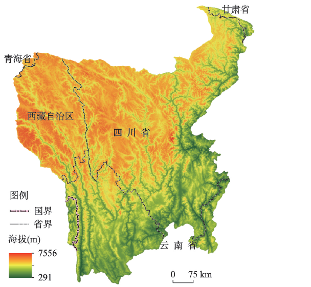
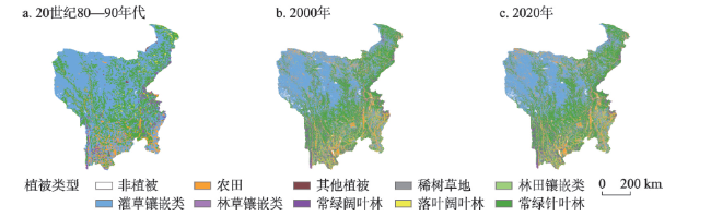
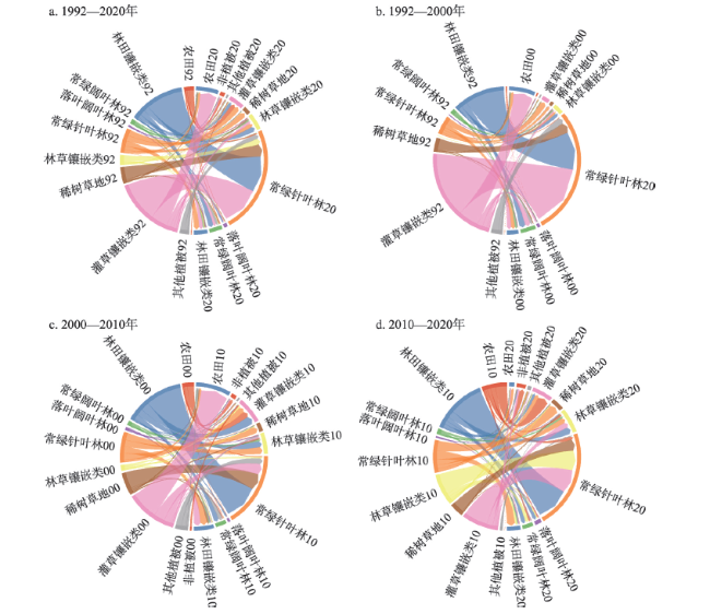
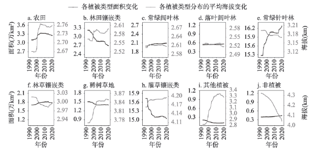
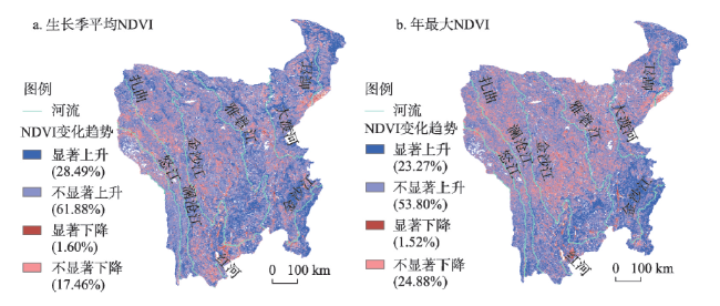
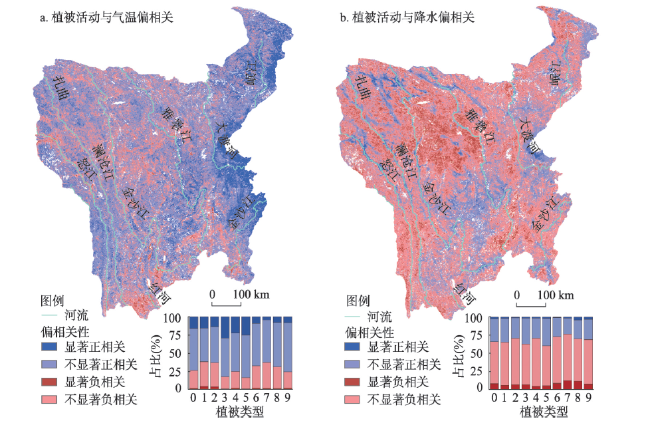
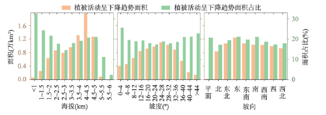
横断山区位于青藏高原东缘和多条重要江河的上游,是全球生物多样性最丰富的地区和生态保护的优先区域之一,区域植被对维系区域生态安全和可持续发展起着十分重要的作用。20世纪90年代以来,中国在横断山区实施了多项重大生态恢复和建设工程,但囿于资料和调查不足,对于横断山区全域性、长时段的植被变化及其与海拔关系研究相对较少。鉴此,本文结合使用1992—2020年间多种基于卫星遥感资料生产的土地覆被数据和2000—2020年间MODIS的归一化植被指数(NDVI)数据,采用转移矩阵、Theil-Sen Median趋势分析与偏相关分析等方法研究不同植被类型转换、植被覆被面积与平均海拔变化关系以及植被活动的时空变化趋势,并分析时空变化的主要影响因素。结果表明:① 横断山区分布最广泛的植被类型是常绿针叶林与灌丛—草地镶嵌类型。植被发生变化的区域集中分布在河谷和南部低海拔区域,草地多向森林特别是常绿针叶林转换,植被覆被逐渐向好。这表明封山育林、植树造林、退耕还林等生态保护政策起到重要积极作用。时间序列数据显示,植被覆被面积变化剧烈的时期往往处在政策实施的起始阶段。② 植被活动整体呈现增强趋势。在植被类型未变化的区域中,75%以上区域植被活动增强,其中超20%的区域显著增强(P < 0.05),且森林植被活动增强趋势大于草地。③ 对植被活动影响较大的环境因子主要是气候变化和地形条件。尽管大部分区域植被活动受气候变暖影响而增强,但在干热河谷的植被活动明显受到降水减少的限制。有近1/4面积的植被活动在减弱,主要分布在山地东坡或南坡,或与降水较多、山高坡陡而造成滑坡、泥石流等自然灾害有关。这些发现可为横断山区生态保护政策效益评估、自然灾害综合风险评估和未来气候变化影响下的植被变化预测提供参考。
关键词: 横断山区; 植被分布; 植被活动; 转移矩阵; Theil-Sen Median趋势分析
杨靖 , 戴君虎 , 姚华荣 , 陶泽兴 , 朱梦瑶 . 1992—2020年横断山区植被分布与植被活动变化[J]. 地理学报, 2022 , 77(11) : 2787 -2802 . DOI: 10.11821/dlxb202211007
The Hengduan Mountains is one of the most biologically diverse areas in the world, geographically located in the eastern part of the Qinghai-Tibet Plateau and the upstream of several major rivers. These mountains are ecologically conservated, with an extremely important ecological barrier function. Since 1990s, China has implemented several significant ecological restoration and construction projects in the research area. Due to limited data and lack of field investigations, few studies explored the integrity and long-term vegetation changes in this area. Hardly any of them discussed the systematical relationship between vegetation changes and elevation factors of the Hengduan Mountains. In view of filling this research gap, we used the Climate Change Initiative Land Cover (CCI-LC) dataset for the period 1992-2020 and the Normal Difference Vegetation Index (NDVI) dataset from MODIS for the period 2000-2020 to reflect changes in vegetation distribution and activity, respectively. Here, we used transfer matrices to investigate the transition relationships among different vegetation types, and used Theil-Sen Median trend analysis to explore the spatial and temporal trends of vegetation activities. We also used the partial correlation analysis to quantify the influencing factors of vegetation activities. Herein, the relationship between vegetation coverage area and mean elevation change was also investigated. The results showed that: (1) The most widely distributed vegetation in the study area contained evergreen coniferous forests and shrub-grass types. Vegetation changes were distributed in river valleys, and southern low-altitude areas. The grasslands were mainly converted to evergreen coniferous forests to gradually improve the vegetation coverage. This showed that ecological protection policies played an essential role. However, vegetation coverage changes are generally in the initial stage of policy implementation. (2) The overall vegetation activity showed an increasing trend. In unchanged vegetation regions, vegetation activities increased in more than 75% of the area, and more than 20% of the area increased significantly (P < 0.05). The changing trend of forest vegetation was more significant than that of grassland. (3) The environmental factors that significantly impact vegetation activities are climate change and topographic slope. Although vegetation coverage was enhanced by increasing temperatures, the precipitation influenced the vegetation in hot and dry valleys. Nearly 25% of the total research area shows a decreasing. This decreasing trend is due to natural disasters such as landslides and mudslides caused by much precipitation and steep mountain slopes. These findings can provide a reference for the evaluation of ecological protection policies, the comprehensive risk assessment of natural disasters, and the prediction of vegetation changes under the influence of future climate change in the Hengduan Mountains.
表1 横断山区各植被类型年均NDVI增长趋势及显著性Tab. 1 Trends of the annual mean NDVI of each vegetation type in the Hengduan Mountains |
| 生长季平均NDVI | 生长季平均NDVI增速 | R2 | 增长趋势在该类型的占比(%) | 显著增长趋势在该类型的占比(%) | |
|---|---|---|---|---|---|
| 农田 | 0.479 | 0.016/10a** | 0.32 | 72.36 | 30.85 |
| 林田镶嵌类 | 0.483 | 0.019/10a** | 0.32 | 76.20 | 28.27 |
| 常绿阔叶林 | 0.633 | 0.024/10a** | 0.43 | 90.30 | 40.75 |
| 落叶阔叶林 | 0.558 | 0.012/10a | 0.08 | 68.69 | 19.68 |
| 常绿针叶林 | 0.582 | 0.021/10a** | 0.45 | 87.40 | 40.26 |
| 林草镶嵌类 | 0.544 | 0.015/10a** | 0.15 | 76.68 | 18.65 |
| 稀树草地 | 0.493 | 0.011/10a | 0.09 | 74.23 | 12.77 |
| 灌草镶嵌类 | 0.426 | 0.012/10a* | 0.24 | 76.69 | 16.18 |
| 其他植被 | 0.405 | 0.005/10a | 0.03 | 74.65 | 15.76 |
注:**表示在P < 0.01下显著,*表示在P < 0.05下显著。 |
| [1] |
|
| [2] |
|
| [3] |
[吴绍洪, 潘韬, 曹杰, 等. 西南纵向岭谷地形对季风的“通道—阻隔”作用. 地理研究, 2012, 31(1): 1-13.]
|
| [4] |
[陈昌笃. 都江堰地区─横断山北段生物多样性交汇、分化和存留的枢纽地段. 生态学报, 2000, 20(1): 28-34.]
|
| [5] |
|
| [6] |
[李宗省, 何元庆, 辛惠娟, 等. 我国横断山区1960—2008年气温和降水时空变化特征. 地理学报, 2010, 65(5): 563-579.]
|
| [7] |
[徐飞, 贾仰文, 牛存稳, 等. 横断山区气温和降水年季月变化特征. 山地学报, 2018, 36(2): 171-183.]
|
| [8] |
[李静, 夏传福, 柳钦火, 等. 1 km growing season length data product over China-ASEAN (2013). Journal of Global Change Data & Discovery, 2017, 1(3): 278-281, 278.]
|
| [9] |
[毛刚, 胡月萍, 陈媛. 地质灾害频发山区聚落安全性探索: 以横断山系的集镇和村庄为例. 西安建筑科技大学学报(自然科学版), 2014, 46(1): 101-108.]
|
| [10] |
[胡凯衡, 魏丽, 刘双, 等. 横断山区泥石流空间格局和激发雨量分异性研究. 地理学报, 2019, 74(11): 2303-2313.]
|
| [11] |
[胡实, 占车生, 赵茹欣, 等. 横断山区植被绿度的时空变化特征及其成因. 山地学报, 2019, 37(5): 669-680.]
|
| [12] |
[王强, 张廷斌, 易桂花, 等. 横断山区2004—2014年植被NPP时空变化及其驱动因子. 生态学报, 2017, 37(9): 3084-3095.]
|
| [13] |
|
| [14] |
|
| [15] |
|
| [16] |
[陈国阶. 长江上游退耕还林与天然林保护的问题与对策. 长江流域资源与环境, 2001, 10(6): 544-549.]
|
| [17] |
[刘伦辉, 余有德, 张建华. 横断山自然植被垂直带的划分. 云南植物研究, 1984, 6(2): 205-216.]
|
| [18] |
[刘伦辉, 余有德, 张建华. 横断山地区植被分布规律的探讨. 云南植物研究, 1985, 7(3): 323-335.]
|
| [19] |
[姚永慧, 张百平, 韩芳, 等. 横断山区垂直带谱的分布模式与坡向效应. 山地学报, 2010, 28(1): 11-20.]
|
| [20] |
[张新时, 中国科学院中国植被图编辑委员会. 中华人民共和国植被图(1:1000000). 北京: 地质出版社, 2007.]
|
| [21] |
[陈珊珊, 温兆飞, 马茂华, 等. 气候变化背景下定量解析生态工程对植被动态影响的研究方法综述. 生态学报, 2022, 42(15): 6439-6449.]
|
| [22] |
[吴桐雯, 李江海, 闻丞. 申遗背景下的中国自然遗产潜力评估. 中国园林, 2019, 35(6): 56-60.]
|
| [23] |
[郑景云, 尹云鹤, 李炳元. 中国气候区划新方案. 地理学报, 2010, 65(1): 3-12.]
|
| [24] |
[吴征镒, 中国植被编辑委员会. 中国植被. 北京: 科学出版社, 1980.]
|
| [25] |
|
| [26] |
[刘琼欢, 张镱锂, 刘林山, 等. 七套土地覆被数据在羌塘高原的精度评价. 地理研究, 2017, 36(11): 2061-2074.]
|
| [27] |
|
| [28] |
|
| [29] |
|
| [30] |
[朴世龙, 方精云, 郭庆华. 利用CASA模型估算我国植被净第一性生产力. 植物生态学报, 2001, 25(5): 603-608, 644.]
|
| [31] |
[南希, 李爱农, 边金虎, 等. 典型山区SRTM3与ASTER GDEM数据精度对比分析: 以青藏高原东麓深切河谷区为例. 地球信息科学学报, 2015, 17(1): 91-98.]
|
| [32] |
[汤国安, 宋佳. 基于DEM坡度图制图中坡度分级方法的比较研究. 水土保持学报, 2006, 20(2): 157-160, 192.]
|
| [33] |
|
| [34] |
[肖笃宁, 赵羿, 孙中伟, 等. 沈阳西郊景观格局变化的研究. 应用生态学报, 1990, 1(1): 75-84.]
|
| [35] |
|
| [36] |
[蔡博峰, 于嵘. 基于遥感的植被长时序趋势特征研究进展及评价. 遥感学报, 2009, 13(6): 1170-1186.]
|
| [37] |
[侯西勇, 应兰兰, 高猛, 等. 1998—2008年中国东部沿海植被覆盖变化特征. 地理科学, 2010, 30(5): 735-741.]
|
| [38] |
[穆少杰, 李建龙, 陈奕兆, 等. 2001—2010年内蒙古植被覆盖度时空变化特征. 地理学报, 2012, 67(9): 1255-1268.]
|
| [39] |
[丁一汇, 张莉. 青藏高原与中国其他地区气候突变时间的比较. 大气科学, 2008, 32(4): 794-805.]
|
| [40] |
[张风春, 杨小玲, 钦立毅. 《中国生物多样性保护战略与行动计划》解读. 环境保护, 2010, 38(19): 8-10.]
|
| [41] |
The Compilation Group of China National Research Report on Biodiversity. China National Research Report on Biodiversity. Beijing: China Environmental Science Press, 1998: 147-156.
[《中国生物多样性国情研究报告》编写组. 中国生物多样性国情研究报告. 北京: 中国环境科学出版社, 1998: 147-156.]
|
| [42] |
[肖能文, 赵志平, 李果, 等. 中国生物多样性保护优先区域生物多样性调查和评估方法. 生态学报, 2022, 42(7): 2523-2531.]
|
| [43] |
[吴学靖, 余昌元. 哈巴雪山省级自然保护区植被分布特征及其多样性保护研究. 林业调查规划, 2020, 45(1) : 47-51.]
|
| [44] |
[朱华. 云南植被多样性研究. 西南林业大学学报(自然科学), 2022, 42(1): 1-12.]
|
| [45] |
[邓喜庆, 皇宝林, 温庆忠, 等. 云南松林在云南的分布研究. 云南大学学报(自然科学版), 2013, 35(6): 843-848.]
|
| [46] |
[张雪梅, 房世波. 干旱河谷地区退耕还林调查与生态还林分析. 干旱区资源与环境, 2007, 21(6): 146-150.]
|
| [47] |
[马海云, 张林林, 魏学琼, 等. 2000—2015年西南地区土地利用与植被覆盖的时空变化. 应用生态学报, 2021, 32(2): 618-628.]
|
| [48] |
[金振洲, 区普定. 我国的硬叶常绿阔叶林. 云南大学学报(自然科学版), 1981, 3(2): 13-20.]
|
| [49] |
|
| [50] |
[张镱锂, 刘林山, 王兆锋, 等. 青藏高原土地利用与覆被变化的时空特征. 科学通报, 2019, 64(27): 2865-2875.]
|
| [51] |
[刘纪远, 匡文慧, 张增祥, 等. 20世纪80年代末以来中国土地利用变化的基本特征与空间格局. 地理学报, 2014, 69(1): 3-14.]
|
| [52] |
[熊巧利, 何云玲, 李同艳, 等. 西南地区生长季植被覆盖时空变化特征及其对气候与地形因子的响应. 水土保持研究, 2019, 26(6): 259-266.]
|
| [53] |
[张亮, 丁明军, 张华敏, 等. 1982—2015年长江流域植被覆盖度时空变化分析. 自然资源学报, 2018, 33(12): 2084-2097.]
|
| [54] |
[刘静, 温仲明, 刚成诚. 黄土高原不同植被覆被类型NDVI对气候变化的响应. 生态学报, 2020, 40(2): 678-691.]
|
| [55] |
[阎建忠, 张镱锂, 摆万奇, 等. 基于植被演替的土地覆被变化研究: 大渡河上游的森林采伐、更新和退化. 中国科学(D辑: 地球科学), 2005, 35(11): 1060-1073.]
|
| [56] |
|
| [57] |
[刘星雨, 周广胜, 吕晓敏, 等. 横断山区地表真实面积与垂直投影面积差异分析: 以雅江县为例. 测绘通报, 2021, 67(8): 37-41.]
|
/
| 〈 |
|
〉 |

