
地形位指数模型改进及其在植被覆盖评价中的应用
|
张玉(1999-), 女, 江苏宿迁人, 硕士生, 中国地理学会会员(S110015164A), 主要从事土地利用与生态政策评价研究。E-mail: xn_zhangyu@126.com |
收稿日期: 2022-02-28
修回日期: 2022-08-26
网络出版日期: 2022-12-27
基金资助
国家自然科学基金项目(42071416)
Improvement of terrain niche index model and its application in vegetation cover evaluation
Received date: 2022-02-28
Revised date: 2022-08-26
Online published: 2022-12-27
Supported by
National Natural Science Foundation of China(42071416)
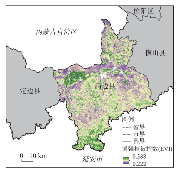
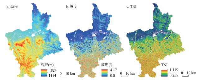
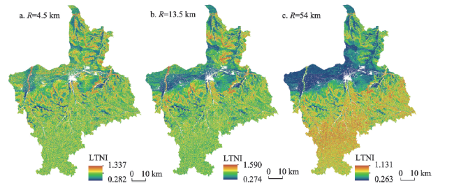
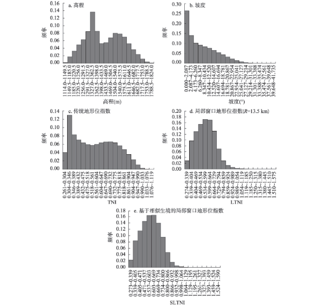
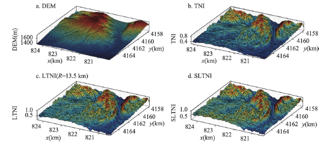
地形作为影响植被覆盖的重要因素,对植被恢复评价以及生态修复规划意义重大。地形位作为测度地形因子综合效应的指标,具有单一地形因子难以比拟的优势。然而,现有地形位指数算法以整个研究区为参照,未考虑空间异质性,难以反映植被生长的局部环境特征。基于地理学第三定律对地理环境相似的强调,融合“空间位置邻近”和“环境特征相似”,对传统地形位模型进行改进:① 引入局部窗口算法,以突出局部地形特征;② 在不同生境因子组合下测算地形位指数,以排除环境差异对地形位作用的干扰。案例研究表明,新模型有效提升了地形位指数对植被覆盖水平的解释力度;当考虑生境因子组合,且采用最优窗口时,局部窗口地形位指数与植被覆盖度之间的相关性最高。此外,通过观察不同生境组合下的地形位指数发现,在高热少水阴坡和高热少水阳坡条件下,植被覆盖度与局部窗口地形位指数具有更高相关性;可见,越是水资源相对匮乏区域,植被覆盖对局部窗口地形位的响应越敏感。本文有望为植被恢复评价与规划提供新的指标。

张玉 , 张道军 . 地形位指数模型改进及其在植被覆盖评价中的应用[J]. 地理学报, 2022 , 77(11) : 2757 -2772 . DOI: 10.11821/dlxb202211005
As an important factor affecting vegetation coverage, the terrain is of great importance to vegetation restoration evaluation and ecological restoration planning. The terrain niche index (TNI), a comprehensive index proposed to measure the combined topographic effect, has incomparable advantages over any single terrain factor. However, the whole study area was taken as a unit reference for the TNI calculation in the previous algorithms, which did not consider the spatial heterogeneity of terrain factors. As a result, the old TNI cannot well reflect the local environment of vegetation growth. Inspired by the geographical environment similarity emphasized in the Third Law of Geography, this study integrated the "proximity of spatial location" and the "similarity of environmental characteristics", and modified and improved the traditional TNI model in the following two aspects: (1) local window algorithm was introduced to highlight the local terrain features; and (2) the new TNI was calculated in each habitat unit formed by the combination of different environmental factors to eliminate the interference of environmental heterogeneity on the topographic effect. The case study shows that the improved model can increase the explanatory power of TNI on vegetation coverage, and the correlation coefficient between TNI and vegetation coverage can be maximized when considering the habitat unit and adopting the optimized local window. In addition, among different habitat factor combinations, it can be found that locations with higher temperature values and less precipitation values show a much closer correlation between the new TNI and vegetation coverage, which indicates that the more the water-deficient areas are, the more the sensitive vegetation coverage is to the local terrain conditions. As a result, this study is expected to provide new indicators for vegetation restoration evaluation and planning.
表1 生境因子组合编码方法Tab. 1 Habitat combination coding method |
| 序号 | 热量 | 水分 | 坡向 | 生境编码 |
|---|---|---|---|---|
| 1 | A | B | C | A×102+B×10+C |
注:A取值1、2,分别代表低热和高热;B取值1、2,分别代表少水和多水;C取值1、2,分别代表阴坡和阳坡。 |
表2 传统地形指标与EVI的相关系数矩阵Tab. 2 Correlation matrix between traditional topographic indicators and EVI |
| EVI | 高程 | 坡度 | TNI | |
|---|---|---|---|---|
| 高程 | 0.036 | 1.000 | ||
| 坡度 | -0.030 | 0.442 | 1.000 | |
| TNI | -0.049 | 0.555 | 0.974 | 1.000 |
注:EVI表示增强型植被指数;TNI表示传统地形位指数。 |
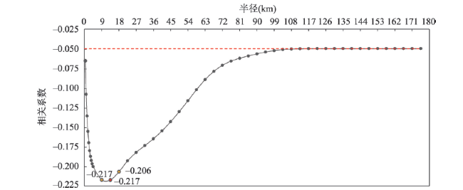
图7 局部窗口地形位指数(LTNI)与增强型植被指数(EVI)间相关系数的变化趋势注:红色水平直线对应的相关系数值为传统地形位指数(TNI)与EVI的相关系数;红色圆点表示LTNI与EVI的最优相关系数;黄色圆点则表示与最优相关系数对应窗口相邻的两个窗口下LTNI与EVI的相关系数。 Fig. 7 Correlation coefficient variation trend between local window terrain niche index (LTNI) and enhanced vegetation index (EVI) with the change of local window size |
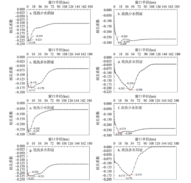
表3 不同生境单元最优尺度局部窗口地形位指数(LTNI)与增强型植被指数(EVI)的相关系数排序Tab. 3 The rank of correlation coefficients between the EVI and the optimal scale LTNI for different habitat combinations |
| 生境分区 | 半径(km) | 最优尺度相关系数 | 排名 |
|---|---|---|---|
| 高热少水阴坡 | 13.5 | -0.299 | 1 |
| 高热少水阳坡 | 18.0 | -0.278 | 2 |
| 低热少水阳坡 | 4.5 | -0.265 | 3 |
| 低热少水阴坡 | 4.5 | -0.223 | 4 |
| 低热多水阳坡 | 9.0 | -0.221 | 5 |
| 高热多水阴坡 | 45.0 | -0.210 | 6 |
| 高热多水阳坡 | 45.0 | -0.176 | 7 |
| 低热多水阴坡 | 13.5 | -0.171 | 8 |
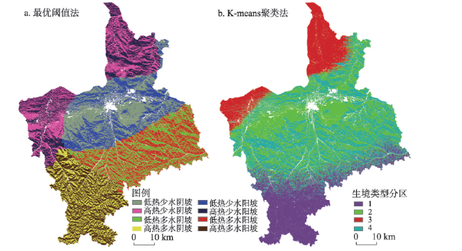
图9 基于最优阈值法和基于K-means聚类法的相似生境分区Fig. 9 Jingbian county division obtained by the spatial overlay of similar habitat based on the optimal threshold method and K-means clustering method |
表4 基于最优阈值法的相似生境下最优尺度局部窗口地形位指数(LTNI)与增强型植被指数(EVI)的相关系数排序Tab. 4 The rank of correlation coefficients between the EVI and the optimal scale LTNI for different habitat combinations based on the optimal threshold method |
| 生境分区 | 半径(km) | 最优尺度相关系数 | 排名 |
|---|---|---|---|
| 高热少水阴坡 | 13.5 | -0.309 | 1 |
| 高热少水阳坡 | 18.0 | -0.301 | 2 |
| 低热少水阳坡 | 4.5 | -0.296 | 3 |
| 低热少水阴坡 | 4.5 | -0.224 | 4 |
| 高热多水阴坡 | 45.0 | -0.194 | 5 |
| 高热多水阳坡 | 45.0 | -0.189 | 6 |
| 低热多水阳坡 | 18.0 | -0.155 | 7 |
| 低热多水阴坡 | 18.0 | -0.133 | 8 |
| [1] |
|
| [2] |
|
| [3] |
|
| [4] |
|
| [5] |
|
| [6] |
|
| [7] |
|
| [8] |
|
| [9] |
|
| [10] |
|
| [11] |
|
| [12] |
|
| [13] |
|
| [14] |
|
| [15] |
|
| [16] |
|
| [17] |
|
| [18] |
[熊礼阳, 汤国安, 杨昕, 等. 面向地貌学本源的数字地形分析研究进展与展望. 地理学报, 2021, 76(3): 595-611.]
|
| [19] |
|
| [20] |
|
| [21] |
|
| [22] |
[彭文甫, 张冬梅, 罗艳玫, 等. 自然因子对四川植被NDVI变化的地理探测. 地理学报, 2019, 74(9): 1758-1776.]
|
| [23] |
|
| [24] |
|
| [25] |
[喻红, 曾辉, 江子瀛. 快速城市化地区景观组分在地形梯度上的分布特征研究. 地理科学, 2001, 21(1): 64-69.]
|
| [26] |
[马士彬, 张勇荣, 安裕伦, 等. 喀斯特石漠化景观空间分布特征分析: 以贵州六枝特区为例. 长江科学院院报, 2015, 32(12): 30-35.]
|
| [27] |
|
| [28] |
[李京京, 吕哲敏, 石小平, 等. 基于地形梯度的汾河流域土地利用时空变化分析. 农业工程学报, 2016, 32(7): 230-236.]
|
| [29] |
[路昌, 雷国平, 周浩, 等. 挠力河流域土地利用变化及地形梯度效应分析. 中国土地科学, 2017, 31(8): 53-60, 97.]
|
| [30] |
|
| [31] |
[方炫, 李壁成, 白小梅, 等. 基于GIS的黄土高原小流域植被格局与地形关系研究: 以固原上黄试区为例. 水土保持研究, 2010, 17(5): 92-95, 100.]
|
| [32] |
|
| [33] |
[马士彬, 安裕伦, 杨广斌, 等. 不同地形梯度上的植被变化趋势及原因分析. 生态环境学报, 2019, 28(5): 857-864.]
|
| [34] |
[陈学兄, 毕如田, 张小军, 等. 太原市城区植被覆盖变化地形分异效应. 水土保持通报, 2020, 40(5): 299-309.]
|
| [35] |
|
| [36] |
|
| [37] |
|
| [38] |
|
| [39] |
[朱阿兴, 闾国年, 周成虎, 等. 地理相似性: 地理学的第三定律? 地球信息科学学报, 2020, 22(4): 673-679.]
|
| [40] |
|
| [41] |
|
| [42] |
|
| [43] |
|
| [44] |
[叶琦, 赵萍, 孙静. 基于MODIS/NDVI与EVI的皖江流域植被覆盖比较分析. 长江流域资源与环境, 2012, 21(3): 361-368.]
|
| [45] |
|
| [46] |
[史巍巍, 裘昱, 戴宗友. 数字高程模型与等高线质量相关性研究. 测绘通报, 2006(2): 23-26.]
|
| [47] |
|
| [48] |
|
| [49] |
|
| [50] |
[周成虎, 孙九林, 苏奋振, 等. 地理信息科学发展与技术应用. 地理学报, 2020, 75(12): 2593-2609.]
|
| [51] |
|
| [52] |
[周明星, 李登秋, 邹建军. 基于稠密Landsat数据的邛崃山大熊猫栖息地植被变化研究. 植物生态学报, 2021, 45(4): 355-369.]
|
| [53] |
[刘玉祯, 刘文亭, 冯斌, 等. 坡向和海拔对高寒山地草甸植被分布格局特征的影响. 草地学报, 2021, 29(6): 1166-1173.]
|
/
| 〈 |
|
〉 |
