
西北“水三线”地区生态经济枢纽区基本理论与建设布局
|
张甜(1991-), 女, 陕西汉中人, 博士, 讲师, 主要从事综合自然地理学与景观生态学研究。E-mail: zhangtiangis@163.com |
收稿日期: 2021-06-21
修回日期: 2022-03-15
网络出版日期: 2022-11-03
基金资助
中国工程院重点咨询项目(2020-XZ-15)
国家自然科学基金项目(42001097)
Basic theories and construction layout of eco-economic pivotal zonesin northwest China based on "Three Water Lines" strategy
Received date: 2021-06-21
Revised date: 2022-03-15
Online published: 2022-11-03
Supported by
Major Academician Consultation Project of Chinese Academy of Engineering(2020-XZ-15)
National Natural Science Foundation of China(42001097)
中国西北地区长期面临资源组合不匹配、区域发展不平衡的问题,而空间区位又决定了其具备促进区域协调、沟通国际国内、调整经济结构、筑牢生态屏障的战略地位。建设具有引领作用的生态经济枢纽区,将有助于改善西北及全国的生态环境问题、提升全域生态安全水平,同时也对国家经济发展具有推动作用。本文立足中国西北“水三线”空间格局,依据国家战略定位与生态经济功能,基于对研究区人地环境、城市群与城镇发展体系、人口布局与民族构成的全面解析,解读生态经济枢纽区的基本内涵,其可归纳为生态功能区、经济枢纽区、文化融生区、深陆通道区四个方面。进一步,本文综合宏观布局、资源禀赋、生态环境、陆海统筹等视角,阐明了生态经济枢纽区建设的功能定位,构建了西北“水三线”地区极点带动、轴带支撑的总体空间布局。并提出河西、兰西、天山北坡、环塔里木盆地绿洲四大生态经济枢纽区的建设格局与发展途径,探索了生态经济枢纽区与国家战略布局的互动关系。以期助力中国新时期西部大开发形成新格局,为中国“一带一路”的“深陆”研究提供科学依据。

张甜 , 黄晓燕 , 李鹏 , 党小虎 , 曹小曙 , 邓铭江 . 西北“水三线”地区生态经济枢纽区基本理论与建设布局[J]. 地理学报, 2022 , 77(9) : 2154 -2173 . DOI: 10.11821/dlxb202209002
Water shortage, unmatched combination of resources and unbalanced regional development are acute problems in northwest China. This region has a strategic location in promoting coordinated regional development, communicating international and domestic markets, adjusting economic structure and building ecological barriers. Therefore, the construction of eco-economic pivotal zones in northwest China would contribute to relieving the eco-environmental dilemma and improving the level of regional ecological security, which has a positive influence on the national economic development. Based on the analysis of human-environment interaction, urban agglomeration and development system, population distribution and ethnic composition in northwest China under the "Three Water Lines" pattern, this study firstly interprets the basic connotation of the eco-economic pivotal zones in this region. We propose that the eco-economic pivotal zone is a strategic area for national and global man-land coordination, which could be defined from the perspectives of ecological function zone, economic hub zone, cultural integration zone and deep-land passage zone. Based on the needs of national macro-strategic layout and land-sea coordination, we clarify the multi-functional orientations of eco-economic pivotal zones. Furthermore, this paper constructs a comprehensive development pattern in northwest China under "Three Water Lines" strategy, which is composed of 9 urban growth poles, 71 city nodes, 4 development axes and 4 eco-economic pivotal zones. And the construction layout as well as the development paths of Hexi, Lanzhou-Xining, north slope of Tianshan Mountains and circum-Tarim Basin eco-economic pivotal zones are also proposed. Finally, this paper discusses the interactive mode between the eco-economic pivotal zones and China's national development strategy layout, which would help the formation of a new pattern of development in western China, and provide a scientific basis for a better understanding of the Belt and Road Initiative.
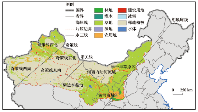
图1 西北“水三线”地区空间范围及分区注:基于自然资源部标准地图服务网站GS(2016)1570号标准地图制作,底图边界无修改。 Fig. 1 Location and subareas of the "Three Water Lines" area in northwest China |
表1 西北“水三线”地区自然生态要素统计Tab. 1 Statistics of natural ecological elements of "Three Water Lines" area in northwest China |
| 分区 | NDVI | NPP(gC/m2) | 降水(mm) | 气温(°C) | |||||||
|---|---|---|---|---|---|---|---|---|---|---|---|
| 均值 | 偏差 | 均值 | 偏差 | 均值 | 偏差 | 均值 | 偏差 | ||||
| 半干旱草原 | 0.35 | 0.12 | 157.06 | -21.85 | 269.05 | 79.13 | 5.19 | -2.97 | |||
| 河西内陆河 | 0.13 | -0.10 | 160.70 | -18.21 | 108.40 | -81.52 | 8.66 | 0.50 | |||
| 黄河流域 | 0.48 | 0.25 | 209.72 | 30.81 | 354.00 | 164.08 | 6.55 | -1.61 | |||
| 柴达木盆地 | 0.24 | 0.01 | 136.31 | -42.60 | 204.05 | 14.13 | 3.49 | -4.67 | |||
| 奇策线西北 | 0.36 | 0.13 | 152.53 | -26.38 | 272.46 | 82.54 | 6.85 | -1.31 | |||
| 奇策线东北 | 0.10 | -0.13 | 96.75 | -82.16 | 98.00 | -91.92 | 10.11 | 1.95 | |||
| 奇策线东南 | 0.11 | -0.12 | 115.34 | -63.57 | 80.38 | -109.54 | 9.99 | 1.83 | |||
| 奇策线西南 | 0.13 | -0.10 | 129.33 | -49.58 | 85.83 | -104.09 | 11.25 | 3.09 | |||
| 小计 | 0.23 | - | 178.91 | - | 189.92 | - | 8.16 | - | |||
注:NDVI及NPP统计自MODIS-MODND1M及MODIS-MOD17A3数据集,降水及气温统计自气象站点插值数据。 |
表2 西北“水三线”地区社会经济要素统计Tab. 2 Statistics of socio-economic elements of "Three Water Lines" area in northwest China |
| 分区 | 人口 | GDP | 一产 | 二产 | 三产 | ||||||||||||
|---|---|---|---|---|---|---|---|---|---|---|---|---|---|---|---|---|---|
| 总值(万人) | 占比(%) | 总值(万人) | 占比(%) | 总值(亿元) | 占比(%) | 结构(%) | 总值(亿元) | 占比(%) | 结构(%) | 总值(亿元) | 占比(%) | 结构(%) | |||||
| 半干旱草原 | 1105 | 10 | 7931 | 15 | 637 | 13 | 8 | 2772 | 12 | 35 | 4522 | 19 | 57 | ||||
| 河西内陆河 | 516 | 4 | 2321 | 5 | 320 | 7 | 14 | 920 | 4 | 40 | 1082 | 4 | 46 | ||||
| 黄河流域 | 7410 | 66 | 27003 | 52 | 1750 | 35 | 7 | 13006 | 58 | 48 | 12247 | 51 | 45 | ||||
| 柴达木盆地 | 81 | 1 | 709 | 1 | 56 | 1 | 8 | 447 | 2 | 63 | 206 | 1 | 29 | ||||
| 奇策线西北 | 1088 | 10 | 9291 | 18 | 1196 | 24 | 13 | 3624 | 16 | 39 | 4471 | 18 | 48 | ||||
| 奇策线东北 | 119 | 1 | 847 | 2 | 90 | 2 | 11 | 479 | 2 | 56 | 278 | 1 | 33 | ||||
| 奇策线东南 | 124 | 1 | 1028 | 2 | 155 | 3 | 15 | 560 | 3 | 55 | 312 | 1 | 30 | ||||
| 奇策线西南 | 813 | 7 | 2599 | 5 | 742 | 15 | 28 | 773 | 3 | 30 | 1085 | 5 | 42 | ||||
| 小计 | 11255 | / | 51729 | / | 4945 | / | 9 | 22581 | / | 44 | 24202 | / | 47 | ||||
注:数据汇总自2018年对应区域县域社会经济统计年鉴。 |
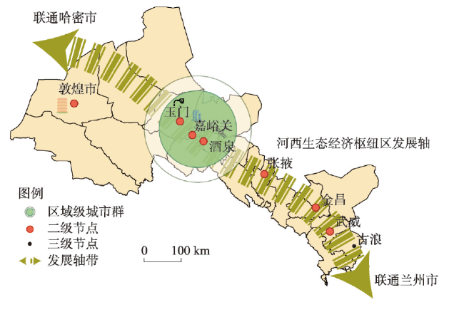
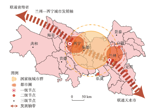
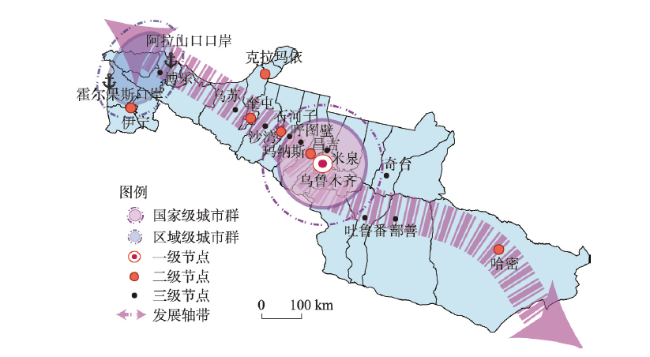
表3 西北“水三线”地区重点发展节点Tab. 3 The important city nodes of "Three Water Lines" area in northwest China |
| 节点等级 | 具体城市 |
|---|---|
| 一级节点 | 乌鲁木齐、西宁、兰州、银川、呼和浩特、西安 |
| 二级节点 | 阿图什、喀什、和田、阿克苏、库尔勒、若羌、伊宁、奎屯、石河子、克拉玛依、昌吉、哈密、敦煌、玉门、嘉峪关、酒泉、张掖、金昌、武威、白银、临夏、定西、天水、宝鸡、咸阳、吴忠、石嘴山、包头、鄂尔多斯、榆林 |
| 三级节点 | 疏附、疏勒、伽师、图木舒克、柯坪、阿拉尔、温宿、库车、铁门关、尉犁、铁干里克、皮山、昆玉、民丰、且末、格尔木、博乐、乌苏、吐鲁番、沙湾、玛纳斯、呼图壁、米泉、奇台、鄯善、海晏、共和、贵德、乐都、夏河、古浪、景泰、漳县、临河、乌海 |
| [1] |
[邓铭江. 中国西北“水三线”空间格局与水资源配置方略. 地理学报, 2018, 73(7): 1189-1203.]
|
| [2] |
[石玉林, 任阵海, 雷志栋, 等. 西北地区土地荒漠化与水土资源利用研究. 北京: 科学出版社, 2004.]
|
| [3] |
[邓铭江, 龙爱华, 李江, 等. 西北内陆河流域“自然—社会—贸易”三元水循环模式解析. 地理学报, 2020, 75(7): 1333-1345.]
|
| [4] |
[杨红伟, 高原. 论西北在中国边防与国家安全史上的地位与作用. 西北第二民族学院学报(哲学社会科学版), 2005(2): 5-9.]
|
| [5] |
[冀朝鼎. 中国历史上的基本经济区. 北京: 商务印书馆, 2014.]
|
| [6] |
[魏晓文. 陆大道, 解读中国经济的“地理密码”. 科技创新与品牌, 2019(8): 21-23.]
|
| [7] |
[杜德斌, 马亚华. “一带一路”: 中华民族复兴的地缘大战略. 地理研究, 2015, 34(6): 1005-1014.]
|
| [8] |
[钱正英, 沈国舫, 潘家铮. 西北地区水资源配置生态环境建设和可持续发展战略研究(综合卷). 北京: 科学出版社, 2004.]
|
| [9] |
The Central People's Government of the People's Republic of China. China unveils guideline on advancing western development in new era. http://www.gov.cn/zhengce/2020-05/17/content_5512456.htm, 2020-05-18.
[中华人民共和国中央人民政府. 中共中央国务院关于新时代推进西部大开发形成新格局的指导意见. http://www.gov.cn/zhengce/2020-05/17/content_5512456.htm, 2020-05-18.]
|
| [10] |
[原伟鹏, 孙慧. 改革开放40年我国西北地区经济高质量发展评价. 新疆大学学报(哲学·人文社会科学版), 2021, 49(1): 23-33.]
|
| [11] |
[方创琳. 中国西部地区城市群形成发育现状与建设重点. 干旱区地理, 2010, 33(5): 667-675.]
|
| [12] |
[叶裕民, 陈丙欣. 中国城市群的发育现状及动态特征. 城市问题, 2014(4): 9-16.]
|
| [13] |
[方创琳. 中国城市群研究取得的重要进展与未来发展方向. 地理学报, 2014, 69(8): 1130-1144.]
|
| [14] |
[陆大道. 论区域的最佳结构与最佳发展: 提出“点—轴系统”和“T”型结构以来的回顾与再分析. 地理学报, 2001, 56(2): 127-135.]
|
| [15] |
[郭爱君, 毛锦凰. 丝绸之路经济带与西北城市群协同发展研究. 甘肃社会科学, 2016(1): 74-79.]
|
| [16] |
Research Group of the Macroeconomic Research Center of the CASS. Research on the potential growth of the Chinese's economy in the next 15 years and the main goals and indicators of economic and social development during the 14th Five-Year Plan period. China Industrial Economics, 2020(4): 5-22.
[中国社会科学院宏观经济研究中心课题组. 未来15年中国经济增长潜力与“十四五”时期经济社会发展主要目标及指标研究. 中国工业经济, 2020(4): 5-22.]
|
| [17] |
[李铭, 方创琳. 基于自组织模型的酒嘉玉地区城市化动态演变. 地理研究, 2006, 25(3): 551-559.]
|
| [18] |
[雷军, 李建刚, 段祖亮, 等. 喀什城市圈城镇化与生态环境交互胁迫效应研究综述. 干旱区地理, 2018, 41(6): 1358-1366.]
|
| [19] |
[陈明星, 李扬, 龚颖华, 等. 胡焕庸线两侧的人口分布与城镇化格局趋势: 尝试回答李克强总理之问. 地理学报, 2016, 71(2): 179-193.]
|
| [20] |
[郑长德. 2000年以来中国少数民族人口的增长与分布. 西北人口, 2013, 34(2): 1-5.]
|
| [21] |
[王朋岗. 我国少数民族人口发展分析: 来自“六普”数据的初步分析. 广西民族研究, 2013(1): 144-153.]
|
| [22] |
[张远鹏, 张莉. 陆海统筹推进“一带一路”建设探索. 太平洋学报, 2019, 27(2): 63-70.]
|
| [23] |
[刘慧, 刘卫东. “一带一路”建设与我国区域发展战略的关系研究. 中国科学院院刊, 2017, 32(4): 340-347.]
|
| [24] |
[董志勇, 李成明. 国内国际双循环新发展格局: 历史溯源、逻辑阐释与政策导向. 中共中央党校(国家行政学院)学报, 2020, 24(5): 47-55.]
|
| [25] |
[范恒山, 肖金成, 陈耀, 等. 西部大开发: 新时期新格局. 区域经济评论, 2020(5): 1-15.]
|
| [26] |
[李营辉, 毕颖. 新时代总体国家安全观的理论逻辑与现实意蕴. 人民论坛·学术前沿, 2018(17): 84-87.]
|
| [27] |
[李世勇, 杨玉良. 边疆安全视角下的西北地区和谐民族关系建构. 西北民族大学学报(哲学社会科学版), 2017(6): 57-63.]
|
| [28] |
[黄征学, 覃成林, 李正图, 等. “十四五”时期的区域发展. 区域经济评论, 2019(6): 1-12, 165.]
|
| [29] |
[董锁成, 黄永斌, 李泽红, 等. 丝绸之路经济带经济发展格局与区域经济一体化模式. 资源科学, 2014, 36(12): 2451-2458.]
|
| [30] |
[邓铭江. 南疆未来发展的思考: 塔里木河流域水问题与水战略研究. 干旱区地理, 2016, 39(1): 1-11.]
|
| [31] |
People's Government of Gansu Province, Department of Housing and Urban-Rural Development of Gansu Province. Urban System Planning of Gansu Province(2013—2030).
[甘肃省人民政府, 甘肃省住房和城乡建设厅. 甘肃省城镇体系规划(2013—2030).]
|
| [32] |
National Development and Reform Commission, Ministry of Housing and Urban-Rural Development of the People's Republic of China. Lanzhou-Xining Urban Agglomeration Development Planning. 2018.
[国家发展改革委, 住房城乡建设部. 兰州—西宁城市群发展规划. 2018.]
|
| [33] |
[方创琳. 天山北坡城市群可持续发展战略思路与空间布局. 干旱区地理, 2019, 42(1): 1-11.]
|
| [34] |
[杨荣金, 孟伟, 段宁, 等. 天山北坡经济带生态文明建设战略研究. 中国工程科学, 2017, 19(4): 40-47.]
|
| [35] |
The Government of Xinjiang Uygur Autonomous Region of China. Urban System Planning of Xinjiang Uygur Autonomous Region (2012-2030).
[新疆维吾尔自治区人民政府. 新疆城镇体系规划(2012-2030).]
|
| [36] |
Department of Natural Resources of Xinjiang Uygur Autonomous Region. Territorial and Spatial Planning of Xinjiang Uygur Autonomous Region (2021-2035).
[新疆维吾尔自治区自然资源厅. 新疆维吾尔自治区国土空间规划(2021—2035年).]
|
| [37] |
Literature Research Office of the CPC Central Committee, CPC Xinjiang Production and Construction Corps Committee. Selected Working Documents of Xinjiang Production and Construction Corps (1949-2014). Beijing: Central Party Literature Press, 2014.
[中共中央文献研究室, 中共新疆生产建设兵团委员会. 新疆生产建设兵团工作文献选编(1949—2014年). 北京: 中央文献出版社, 2014.]
|
| [38] |
[李鲁奇, 马学广, 鹿宇. 飞地经济的空间生产与治理结构: 基于国家空间重构视角. 地理科学进展, 2019, 38(3): 346-356.]
|
| [39] |
[贾绍凤. 优化黄河上游水土资源配置为国家粮食安全作贡献. 中国水利, 2020(21): 29-31.]
|
| [40] |
[孙早, 谢慧莹, 刘航. 国内国际双循环新格局下的西部高水平开放型经济发展. 西安交通大学学报(社会科学版), 2021, 41(1): 1-7.]
|
/
| 〈 |
|
〉 |


