
月表地貌起伏形态分异特征及分级标准研究
|
邓佳音(1994-), 女, 河南周口人, 博士生, 主要从事数字地貌分析。E-mail: dengjy.20b@igsnrr.ac.cn |
收稿日期: 2021-12-09
修回日期: 2022-04-07
网络出版日期: 2022-09-13
基金资助
中国科学院先导科技专项(XDB41000000)
国家自然科学基金项目(42130110)
国家自然科学基金项目(41571388)
国家科技基础性工作专项(2015FY210500)
Morphological differentiation characteristics and classification criteria of lunar surface relief amplitude
Received date: 2021-12-09
Revised date: 2022-04-07
Online published: 2022-09-13
Supported by
Strategic Priority Research Program of the Chinese Academy of Sciences(XDB41000000)
National Natural Science Foundation of China(42130110)
National Natural Science Foundation of China(41571388)
Key Projects of National Basic Work of Science and Technology(2015FY210500)
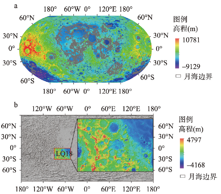
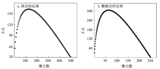
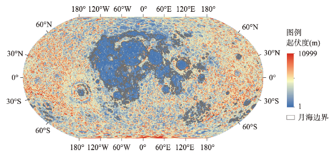
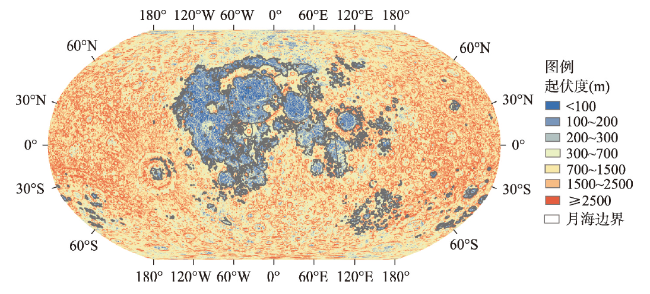
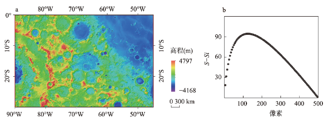
月球地貌是月球表面发生的地质和地貌过程的结果,月球地貌单元的划分和等级分类体系的构建是月球地貌学研究的基础,也是月球地貌图制图的基础和关键科学问题。地貌学是研究形态和成因的科学,高程和起伏度是最基本的地貌指标。本文基于LOLA(Lunar Orbiter Laser Altimeter) DEM数据以及LOLA和SELENE TC(Terrain Camera)融合的DEM数据(SLDEM2015,文中简称SLDEM),利用均值变点法确定月表起伏度计算的最佳窗口,并以起伏度100 m、200 m、300 m、700 m、1500 m及2500 m为阈值将月球表面分为微起伏平原(< 100 m)、微起伏台地[100 m, 200 m)、微小起伏丘陵[200 m, 300 m)、小起伏山地[300 m, 700 m)、中起伏山地[700 m, 1500 m)、大起伏山地[1500 m, 2500 m)及极大起伏山地(≥ 2500 m)地貌7个类型。划分结果显示:微起伏平原主要分布在月海平原区域、部分有玄武岩充填的撞击盆地的盆底区域以及撞击坑坑底区域;微起伏台地主要分布在月海和月陆区域的交界区域;微小起伏丘陵主要分布在月溪和皱脊等构造单元区域;小起伏山地主要分布在撞击坑中央峰及坑底断裂区域;中起伏山地主要分布在撞击坑坑底和坑壁过渡区域、撞击坑坑壁和坑缘过渡区域、撞击盆地盆底与盆壁过渡区域以及盆壁与盆缘过渡区域;大起伏和极大起伏山地主要分布在撞击坑坑壁区域及撞击盆地盆壁区域。本文确定的月表起伏度分级标准可以对月表数字地貌分类体系的构建和月球地貌图集的编研提供定量标准和重要参考。
邓佳音 , 程维明 , 刘樯漪 , 焦毅蒙 , 刘建忠 . 月表地貌起伏形态分异特征及分级标准研究[J]. 地理学报, 2022 , 77(7) : 1794 -1807 . DOI: 10.11821/dlxb202207015
The lunar landform is the result of the geological and geomorphic processes on the lunar surface. It is very important to identify the type of the lunar landforms. Geomorphology is the scientific study of the origin and evolution of topographic landforms on the planetary surface. Elevation and relief amplitude are the most commonly used geomorphic indexes in the study of geomorphological classification. Previous studies have determined the elevation classification criterion of lunar surface. In this paper, we focus on the classification criterion of the topographic relief amplitude of the lunar surface. As for the estimation of the best window to calculate the relief amplitude of the lunar surface, we used the method of change-point in the mean based on LOLA (Lunar Orbiter Laser Altimeter) DEM data and DEM that combines the LOLA and SELENE TC (Terrain Camera) merged Digital Elevation Model (SLDEM2015). According to the statistical analysis of the basic lunar landforms, the classification criterion of lunar surface relief amplitude is determined. Taking the topographic relief amplitudes of 100 m, 200 m, 300 m, 700 m, 1500 m and 2500 m as the thresholds, the lunar surface is divided into seven geomorphic types, including slightly micro-relief plains (< 100 m), slightly micro-relief platforms [100 m, 200 m), micro-relief landforms [200 m, 300 m), small relief landforms [300 m, 700 m), medium relief landforms [700 m, 1500 m), large relief landforms [1500 m, 2500 m) and extremely large relief landforms (≥ 2500 m). The slightly micro-relief plains are mainly distributed in the maria, and the floor of craters and basins that are filled with basalts, while the slightly micro-relief platforms are mainly distributed in the transition regions between the maria and highlands. The micro-relief landforms are mainly located in the regions with higher topography than the mare, such as wrinkle ridges and sinuous rilles in the mare. The small relief landforms are mainly scattered in the central peak and floor-fractured of craters. The medium relief landforms are mainly distributed in the transition regions between the rater floor and carter wall, between the crater wall and crater rim, between the basin floor and basin wall, and between the basin wall and basin rim. Large and extremely larger relief landforms are mainly scattered in the crater wall and basin wall. The determination of classification criteria of lunar surface relief amplitude in this paper can provide important references for the construction of digital geomorphology classification schemes of the lunar surface.
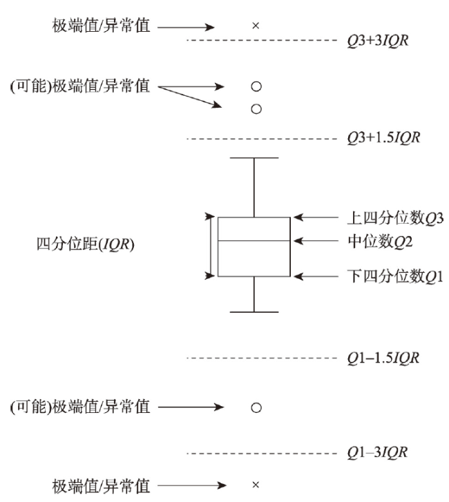
表1 月表地形起伏度统计表Tab. 1 Quantile statistics of lunar surface relief amplitude |
| 统计值 | 最小值 | 下四分位数 | 中位数 | 上四分位数 | 内限阈值 | 外限阈值 | 平均值 |
|---|---|---|---|---|---|---|---|
| 起伏度(m) | 1 | 687 | 1240 | 1939 | 3817 | 5695 | 1393.6 |
注:表中数据由DEM栅格像元数统计得到,存在一定误差。 |
表2 全月起伏度累计频率百分位数Tab. 2 Percentile of accumulated frequency of lunar surface relief amplitude |
| 累计频率(%) | 10 | 20 | 30 | 40 | 50 | 60 | 70 | 80 | 90 |
|---|---|---|---|---|---|---|---|---|---|
| 起伏度(m) | 299 | 562 | 803 | 1022 | 1240 | 1481 | 1767 | 2140 | 2688 |
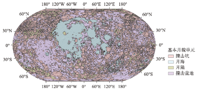
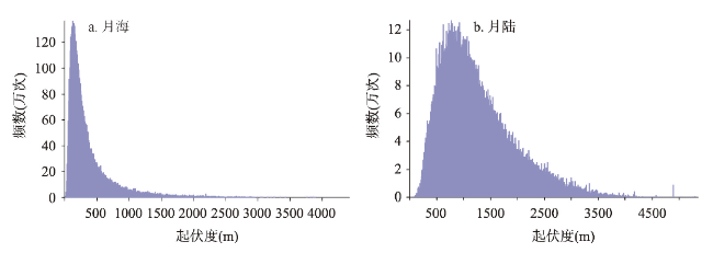
表3 月表基本地貌单元内地形起伏度统计Tab. 3 Quantile statistics of lunar surface relief amplitude in lunar basic geomorphic landforms |
| 基本地貌单元 | 起伏度统计值(m) | |||||
|---|---|---|---|---|---|---|
| 最小值 | 下四分位数 | 中位数 | 上四分位数 | 最大值 | 平均值 | |
| 月海 | 23 | 159 | 253 | 445 | 4772 | 380.27 |
| 月陆 | 1 | 735 | 1082 | 1583 | 5396 | 1231.69 |
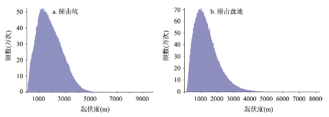
| 撞击坑 | 71 | 1132 | 1721 | 2455 | 7200 | 1842.39 |
| 撞击盆地 | 1 | 794 | 1197 | 1716 | 7200 | 1330.97 |
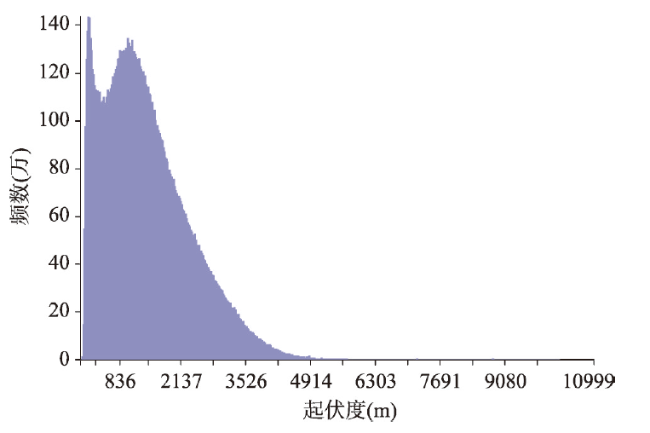
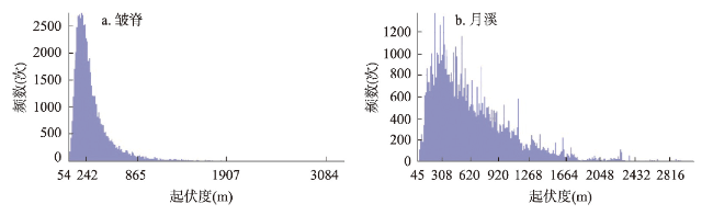
图8 月海皱脊和月溪地形起伏度频数分布直方图Fig. 8 Frequency distribution histogram of lunar wrinkle ridges and lunar sinuous rilles |
表4 月表基本地貌单元起伏度的累积频率以及累积频率对应的地貌单元起伏度值Tab. 4 Cumulative frequency of lunar surface relief amplitude in basic geomorphic landforms and |
| 基本地貌单元 | 累积频率对应的地貌单元起伏度值(m) | ||||||||
|---|---|---|---|---|---|---|---|---|---|
| 10% | 20% | 30% | 40% | 50% | 60% | 70% | 80% | 90% | |
| 月海 | 111 | 143 | 173 | 210 | 253 | 308 | 388 | 521 | 795 |
| 月陆 | 507 | 665 | 802 | 937 | 1082 | 1250 | 1457 | 1734 | 2177 |
| 撞击坑 | 730 | 1013 | 1247 | 1478 | 1721 | 1987 | 2287 | 2642 | 3125 |
| 撞击盆地 | 520 | 709 | 975 | 1034 | 1197 | 1378 | 1589 | 1866 | 2307 |
the relief amplitude corresponding to cumulative frequency |
表5 月表地形起伏度分类统计Tab. 5 Statistics of classification criterion of lunar surface relief amplitude |
| 起伏度分类(m) | |||||||
|---|---|---|---|---|---|---|---|
| <100 | [100, 200) | [200, 300) | [300, 700) | [700, 1500) | [1500, 2500) | ≥ 2500 | |
| 地形名称 | 微起伏平原 | 微起伏台地 | 微小起伏丘陵 | 小起伏山地 | 中起伏山地 | 大起伏山地 | 极大起伏山地 |
| 占比(%) | 1.06 | 4.3 | 4.71 | 15.48 | 35.18 | 27.38 | 12.89 |
| [1] |
[ 欧阳自远. 我国月球探测的总体科学目标与发展战略. 地球科学进展, 2004, 19(3): 351-358.]
|
| [2] |
|
| [3] |
[ 欧阳自远. 月球科学概论. 北京: 中国宇航出版社, 2005.]
|
| [4] |
[ 程维明, 刘樯漪, 王娇, 等. 全月球形貌类型分类方法初探. 地球科学进展, 2018, 33(9): 885-897.]
|
| [5] |
[ 程维明, 周增坡, 万从, 等. 月球形貌科学概论. 北京: 地质出版社, 2016.]
|
| [6] |
[ 周增坡, 程维明, 周成虎, 等. 基于“嫦娥一号”的月表形貌特征分析与自动提取. 科学通报, 2011, 56(1): 18-26.]
|
| [7] |
|
| [8] |
[ 程维明, 王娇, 周成虎. 月表形貌特征研究进展及趋势分析. 地理研究, 2014, 33(6): 1003-1014.]
|
| [9] |
Institute of Geographic Sciences and Natural Resources Research, Chinese Academy of Sciences. 1∶1000000 Geomorphological Mapping Specification (trail). Beijing: Science Press, 1987.
[中国科学院地理研究所. 中国1∶100万地貌图制图规范(试行). 北京: 科学出版社, 1987.]
|
| [10] |
[ 李炳元, 李钜章. 中国1∶400万地貌图. 北京: 科学出版社, 1994.]
|
| [11] |
[ 李炳元, 潘保田, 韩嘉福. 中国陆地基本地貌类型及其划分指标探讨. 第四纪研究, 2008, 28(4): 535-543.]
|
| [12] |
[ 刘樯漪, 程维明, 阎广建, 等. 月表高程分布特征及其分级标准初探. 地理学报, 2021, 76(1): 106-119.]
|
| [13] |
|
| [14] |
|
| [15] |
|
| [16] |
|
| [17] |
|
| [18] |
[ 韩海辉, 高婷, 易欢, 等. 基于变点分析法提取地势起伏度: 以青藏高原为例. 地理科学, 2012, 32(1): 101-104.]
|
| [19] |
[ 涂汉明, 刘振东. 中国地势起伏度最佳统计单元的求证. 湖北大学学报(自然科学版), 1990, 12(3): 266-271.]
|
| [20] |
|
| [21] |
|
| [22] |
|
| [23] |
|
| [24] |
|
| [25] |
|
| [26] |
|
| [27] |
|
| [28] |
|
| [29] |
|
| [30] |
|
| [31] |
|
| [32] |
|
/
| 〈 |
|
〉 |
