
黄河下游水沙关系模型参数随河段距离变化规律
|
申红彬(1981-), 男, 河南安阳人, 博士, 讲师, 主要从事水文学、河流动力学方面的研究工作。E-mail: hongbinshen2012@163.com |
收稿日期: 2021-02-22
要求修回日期: 2021-12-30
网络出版日期: 2022-05-23
基金资助
国家自然科学基金项目(51809013)
城市水循环与海绵城市技术北京市重点实验室开放基金(HYD2019OF02)
版权
Parameters variation law with distance in the discharge-sediment relation model of the Lower Yellow River
Received date: 2021-02-22
Request revised date: 2021-12-30
Online published: 2022-05-23
Supported by
National Natural Science Foundation of China(51809013)
Opening Foundation of Beijing Key Laboratory of Urban Hydrological Cycle and Sponge City Technology(HYD2019OF02)
Copyright
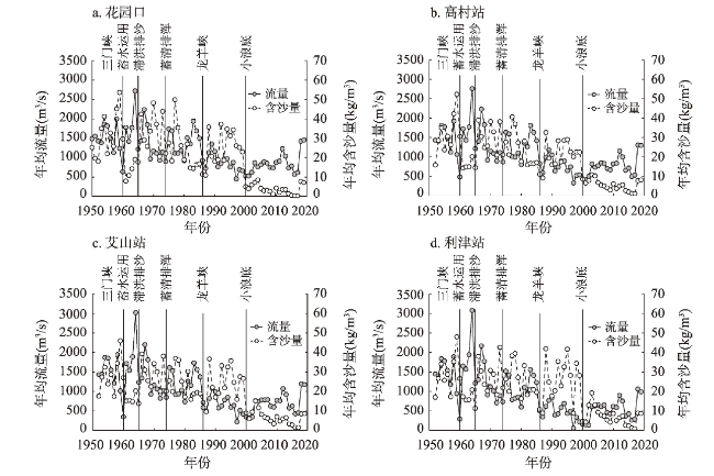
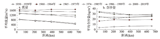
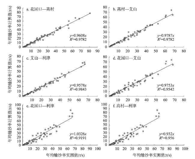
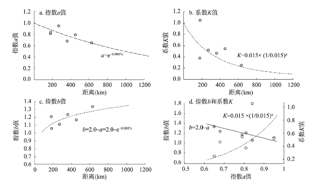
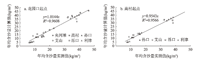
对于多沙河流或河段,水沙关系模型多表示为考虑来水含沙量的幂律函数形式:Qs=KSuaQb,本质反映了河道的不平衡输沙规律,模型参数变化主要受到河道边界条件的影响。河段距离作为反映沿程空间尺度的一个重要指标,对模型系数K与指数a、b具有重要的影响。以黄河下游河道为研究对象,分析研究了模型系数K与指数a、b随河段距离的变化规律与计算方法,并用于黄河下游河道输沙沿程变化模拟。模型参数变化规律分析表明:指数a随河段距离的增大而减小,两者呈指数负相关关系;系数K随河段距离的增大而减小,且与指数a呈指数正相关关系;指数b随河段距离的增大而增大,且与指数a呈线性负相关关系,两者之和约为2.0。通过建立模型系数K与指数a、b随河段距离变化的计算表达式,构成了考虑来水含沙量的水沙关系模型的参数条件补充方程。对黄河下游河道输沙沿程变化模拟结果表明,黄河下游河道沿程含沙量的计算值与实测值变化趋势基本符合,确定性系数R2值可以达到0.96,Nash-Sutcliffe效率系数NSE值在0.93以上,模拟效果良好。研究结果有助于深入认识考虑来水含沙量的水沙关系模型参数的物理意义与探索模型参数的确定方法。
申红彬 , 曹兵 , 吴华莉 , 乔伟 . 黄河下游水沙关系模型参数随河段距离变化规律[J]. 地理学报, 2022 , 77(3) : 635 -649 . DOI: 10.11821/dlxb202203010
The discharge-sediment relation model is an important research technique in river dynamics. Previous studies established a statistical relationship between the sediment transport rate and the flow discharge that follows a power-law form, shown as Qs=AQ b. Studies have also shown that how to determine the model parameters is an important question. However, for heavy sediment-laden rivers, the discharge-sediment relation model is often expressed by a modified power-law relationship between the sediment transport rate and flow discharge, as well as an upstream sediment supply function: Qs=KSuaQb, where the model parameters become more complex. Essentially, the modified model reflects a non-equilibrium sediment transport law, and model parameters including coefficient K and exponents a and b are mainly influenced by river boundary geomorphologic conditions. As an important index reflecting the spatial scale along the river, distance has an important impact on the modified model parameters, namely, coefficient K and exponents a and b. Taking the Lower Yellow River as the research object, we studied the variation laws of the model coefficient K and indexes a and b with distance. The results showed that the exponent a decreases exponentially with the increase of downstream distance; the coefficient K decreases with the increase of downstream distance and has a positive exponential correlation with the exponent a; the exponent b increases with the increase of downstream distance and has a negative linear correlation with the exponent a; and the sum of exponents a and b is about 2.0. From that, the calculation expressions of model coefficient K and exponents a and b varying with the distance were established. As such, it can be regarded as the parameter supplementary equations for the discharge-sediment relation model. Simulation results of sediment transport along the Lower Yellow River showed that the trend of calculated sediment concentrations are consistent with that of measured sediment concentrations. The values of the determination coefficient and Nash-Sutcliffe efficiency are 0.96 and 0.93, respectively. This study helps us to have a better understanding of the physical meaning and exploration of calculation methods for the discharge-sediment relation model parameters in heavy sediment-laden rivers.
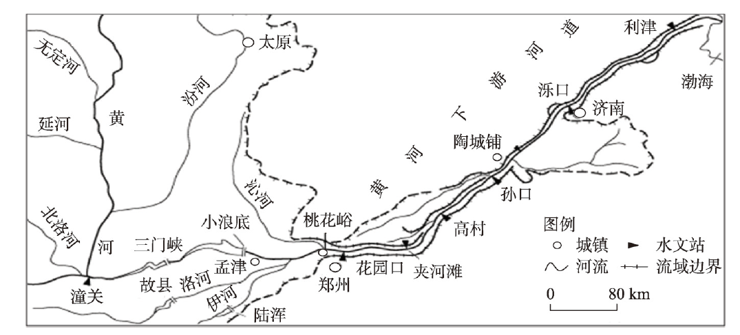
表1 黄河下游河道不同河段特征参数Tab. 1 Characteristic parameters for different reaches in the Lower Yellow River |
| 类型 | 河段 | 分河段 | 距离(km) | 平均比降(‰) | 主槽河宽(km) |
|---|---|---|---|---|---|
| 游荡型 | 桃花峪—高村 | 桃花峪—花园口 | 28.6 | 0.198 | 0.8~2.5 |
| 花园口—夹河滩 | 100.8 | ||||
| 夹河滩—高村 | 77.1 | ||||
| 过渡型 | 高村—陶城铺 | 高村—孙口 | 118.2 | 0.120 | 0.5~1.6 |
| 孙口—陶城铺 | 46.8 | ||||
| 弯曲型 | 陶城铺—利津 | 陶城铺—艾山 | 17.1 | 0.110 | 0.3~0.8 |
| 艾山—泺口 | 101.8 | ||||
| 泺口—利津 | 167.8 |
表2 黄河下游河道不同河段模型参数Tab. 2 Model parameters for different reaches in the Lower Yellow River |
| 河段 | 距离(km) | 模型参数 | 模型效果指标 | |||||
|---|---|---|---|---|---|---|---|---|
| 系数K | 指数a | 指数b | R2 | NSE | ||||
| 基本河段 | 花园口—高村 | 177.9 | 0.38* | 0.81* | 1.21* | 0.978 | 0.975 | |
| 高村—艾山 | 182.1 | 1.05* | 0.84* | 1.06* | 0.978 | 0.977 | ||
| 艾山—利津 | 269.6 | 0.52* | 0.95* | 1.11* | 0.984 | 0.980 | ||
| 扩展河段 | 花园口—艾山 | 360.0 | 0.46+ | 0.68+ | 1.24+ | 0.954 | 0.949 | |
| 花园口—利津 | 629.6 | 0.25+* | 0.65+* | 1.35+* | 0.919 | 0.890 | ||
| 高村—利津 | 451.7 | 0.54+ | 0.79+ | 1.17+ | 0.956 | 0.946 | ||
注:*为参考结果;+为递推结果;+*为参考与递推综合结果。 |
表3 黄河下游河道不同河段模型参数计算值Tab. 3 Calculation values of model parameters for different reaches in the Lower Yellow River |
| 河段 | 模型参数 | 刘月兰等[15] (1987年) | 赵业安等[16] (1989年) | 吴保生等[17] (2007年) | 本文 (2021年) | 他人研究 参数平均值 | ||||||||
|---|---|---|---|---|---|---|---|---|---|---|---|---|---|---|
| 汛期 | 非汛期 | 汛期 | 全年 | 汛期 | 全年 | |||||||||
| 不漫滩 | 漫滩 | |||||||||||||
| 花园口—高村 | 系数K | 0.46 | 5.40 | 0.39 | 0.55 | 0.38 | 0.44 | 0.61 | 1.27 | |||||
| 指数a | 0.76 | 0.76 | 0.49 | 0.76 | 0.81 | 0.81 | 0.88 | 0.73 | ||||||
| 指数b | 1.21 | 1.16 | 1.33 | 1.18 | 1.21 | 1.21 | 1.12 | 1.22 | ||||||
| 高村—艾山 | 系数K | 0.65 | 0.79 | 0.15 | 0.51 | 1.05 | 1.13 | 0.6 | 0.71 | |||||
| 指数a | 0.83 | 0.81 | 1.02 | 0.92 | 0.84 | 0.84 | 0.88 | 0.88 | ||||||
| 指数b | 1.08 | 1.06 | 1.25 | 1.12 | 1.06 | 1.06 | 1.12 | 1.11 | ||||||
| 艾山—利津 | 系数K | 0.43 | 0.43 | 1.23 | 0.6 | 0.52 | 0.57 | 0.49 | 0.63 | |||||
| 指数a | 1.00 | 1.00 | 1.13 | 0.96 | 0.95 | 0.95 | 0.83 | 1.00 | ||||||
| 指数b | 1.09 | 1.09 | 1.21 | 1.09 | 1.11 | 1.11 | 1.17 | 1.12 | ||||||
表4 黄河下游河道沿程模型参数计算值Tab. 4 Calculation values of model parameters along the distance of the Lower Yellow River |
| 距离断面 (km) | 方案1(花园口起点) | 距离断面 (km) | 方案2(高村起点) | ||||||||
|---|---|---|---|---|---|---|---|---|---|---|---|
| 水文站 | 系数K | 指数a | 指数b | 指数c | 水文站 | 系数K | 指数a | 指数b | 指数c | ||
| 0 | 花园口 | 1.00 | 1.00 | 1.00 | 0.00 | 0 | 高村 | 1.00 | 1.00 | 1.00 | 0.00 |
| 100 | — | 0.75 | 0.93 | 1.07 | 0.07 | 50 | — | 0.87 | 0.97 | 1.03 | 0.03 |
| 100.8 | 夹河滩 | 0.75 | 0.93 | 1.07 | 0.07 | 100 | — | 0.75 | 0.93 | 1.07 | 0.07 |
| 177.9 | 高村 | 0.61 | 0.88 | 1.12 | 0.12 | 118.2 | 孙口 | 0.72 | 0.92 | 1.08 | 0.08 |
| 200 | — | 0.58 | 0.87 | 1.13 | 0.13 | 150 | — | 0.66 | 0.90 | 1.10 | 0.10 |
| 296.1 | 孙口 | 0.46 | 0.81 | 1.19 | 0.19 | 182.1 | 艾山 | 0.60 | 0.88 | 1.12 | 0.12 |
| 300 | — | 0.45 | 0.81 | 1.19 | 0.19 | 200 | — | 0.58 | 0.87 | 1.13 | 0.13 |
| 360 | 艾山 | 0.39 | 0.78 | 1.22 | 0.22 | 250 | — | 0.51 | 0.84 | 1.16 | 0.16 |
| 400 | — | 0.36 | 0.76 | 1.24 | 0.24 | 283.9 | 泺口 | 0.47 | 0.82 | 1.18 | 0.18 |
| 461.8 | 泺口 | 0.31 | 0.72 | 1.28 | 0.28 | 300 | — | 0.45 | 0.81 | 1.19 | 0.19 |
| 500 | — | 0.29 | 0.70 | 1.30 | 0.30 | 350 | — | 0.40 | 0.78 | 1.22 | 0.22 |
| 600 | — | 0.24 | 0.66 | 1.34 | 0.34 | 400 | — | 0.36 | 0.76 | 1.24 | 0.24 |
| 629.6 | 利津 | 0.22 | 0.64 | 1.36 | 0.36 | 451.7 | 利津 | 0.32 | 0.73 | 1.27 | 0.27 |
| 700 | — | 0.20 | 0.61 | 1.39 | 0.39 | 500 | — | 0.29 | 0.70 | 1.30 | 0.30 |
| [1] |
[余凤玲. 长江干流水沙关系模型特征、河流地貌学意义及其应用浅析[D]. 上海: 华东师范大学, 2006.]
|
| [2] |
[周文浩, 曾庆华, 赵华侠, 等. 黄河下游河道输沙能力的分析. 泥沙研究, 1994(3): 1-11.]
|
| [3] |
[申冠卿, 张原锋, 侯素珍, 等. 黄河上游干流水库调节水沙对宁蒙河道的影响. 泥沙研究, 2007(1): 67-75.]
|
| [4] |
|
| [5] |
|
| [6] |
|
| [7] |
|
| [8] |
|
| [9] |
|
| [10] |
|
| [11] |
[彭文昌, 李永山. 黄河内蒙古段异源水沙输移特性. 中国沙漠, 2016, 36(3): 805-813.]
|
| [12] |
|
| [13] |
[申红彬, 吴保生. 河流泥沙水文学模型边界条件参数化方法探讨. 水利学报, 2020, 51(2): 193-200.]
|
| [14] |
[钱宁, 张仁, 李九发, 等. 黄河下游挟沙能力自动调整机理的初步探讨. 地理学报, 1981, 36(2): 143-156.]
|
| [15] |
[刘月兰, 韩少发, 吴知. 黄河下游河道冲淤计算方法. 泥沙研究, 1987(3): 30-42.]
|
| [16] |
[赵业安, 潘贤娣, 樊左英, 等. 黄河下游河道冲淤情况及基本规律. 黄河水利委员会水利科学研究所文集: 第一集: 泥沙、水土保持. 郑州: 河南科学技术出版社, 1989: 12-26.]
|
| [17] |
[吴保生, 张原锋. 黄河下游输沙量的沿程变化规律和计算方法. 泥沙研究, 2007(1): 30-35.]
|
| [18] |
|
| [19] |
[傅旭东, 姜立伟, 吴保生, 等. 黄河下游河道场次洪水排沙比及其不确定性. 中国科学: 技术科学, 2010, 40(4): 349-357.]
|
| [20] |
[吴保生, 刘可晶, 申红彬, 等. 黄河内蒙古河段输沙量与淤积量计算方法. 水科学进展, 2015, 26(3): 311-321.]
|
| [21] |
|
| [22] |
[姚文艺, 严忠民, 李勇. 黄河下游河道萎缩过程中输沙能力的调整. 水利水电科技进展, 2006, 26(3): 10-14.]
|
| [23] |
[申红彬, 吴保生. 冲积河流泥沙输移幂律函数指数变化规律. 水科学进展, 2018, 29(2): 179-185.]
|
| [24] |
[孙高虎. 水沙变异条件下黄河下游河道纵横剖面的响应[D]. 北京: 中国水利水电科学研究院, 2006.]
|
| [25] |
[胡胜, 曹明明, 邱海军, 等. CFSR气象数据在流域水文模拟中的适用性评价: 以灞河流域为例. 地理学报, 2016, 71(9): 1571-1586.]
|
| [26] |
|
| [27] |
|
| [28] |
[许炯心. 人类活动影响下的黄河下游河道泥沙淤积宏观趋势研究. 水利学报, 2004, 35(2): 8-16.]
|
| [29] |
[吴保生, 申冠卿. 来沙系数物理意义的探讨. 人民黄河, 2008, 30(4): 15-16.]
|
/
| 〈 |
|
〉 |


