
气候变化影响下藏东南帕隆藏布流域高山区泥石流的地貌效应
|
余国安(1978-), 男, 安徽怀宁人, 博士, 副研究员, 研究方向为泥沙运动、河流地貌及灾害。E-mail: yuga@igsnrr.ac.cn |
收稿日期: 2021-06-02
要求修回日期: 2021-12-30
网络出版日期: 2022-05-23
基金资助
国家重点研发计划(2018YFC1505201)
国家自然科学基金项目(41971010)
第二次青藏高原综合科学考察研究(2019QZKK0903)
版权
Geomorphic effects of debris flows in high mountain areas of the Parlung Zangbo basin, southeast Tibet under the influence of climate change
Received date: 2021-06-02
Request revised date: 2021-12-30
Online published: 2022-05-23
Supported by
National Key R&D Program of China(2018YFC1505201)
National Natural Science Foundation of China(41971010)
The Second Tibetan Plateau Scientific Expedition and Research(2019QZKK0903)
Copyright
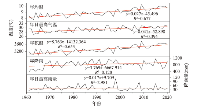
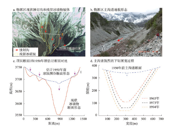
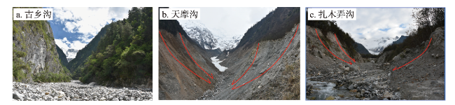
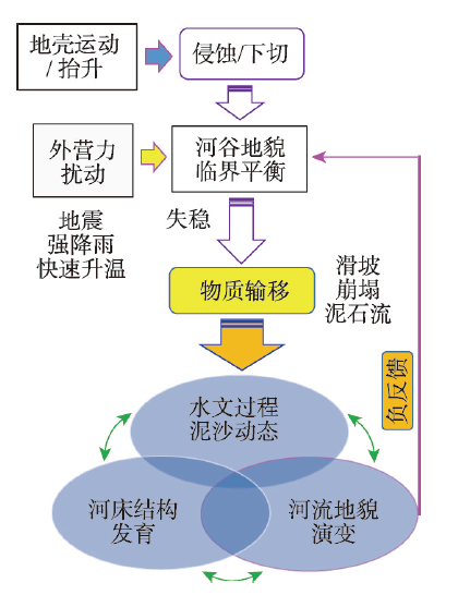
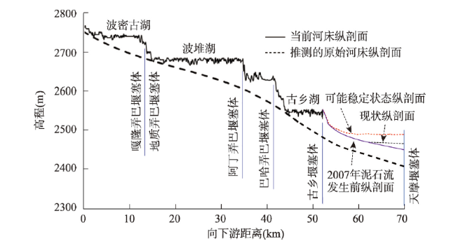
高海拔或高纬度山区(尤其高山冰川及冻土急剧消退区)常孕育适宜泥石流发育的地形和物源条件。气候变化(如升温、强降雨事件增多等)影响下,高山区潜在孕灾环境更易于成灾,泥石流成为主要的灾害类型和物质输移方式,也是高山区地貌变化的重要驱动力。由于野外监测困难,数据资料匮乏,鲜有针对高山区泥石流过程地貌效应的分析报道。以中国藏东南高山区泥石流多发的帕隆藏布流域为研究区,以古乡沟、天摩沟和扎木弄沟为典型小流域,结合遥感影像、DEM数据、无人机航拍、高精度RTK测量和野外踏勘调查,分析泥石流沟道地貌发育特征(冲淤变化、平面摆动)及其对主河河流地貌的影响,并探讨大规模泥石流事件影响下河谷地貌的长期演变趋势。高山区泥石流过程强烈塑造沟道自身地貌,上游物源区深切展宽和溯源蚀退,沟口堆积扇冲淤变化受控于泥石流事件规模和水流强度。泥石流过程显著影响主河道河流地貌,造成主河道横向冲淤和摆动,并影响堰塞体上游河段平面形态发育。长时间尺度上,河谷地貌在平面上发育形成宽窄相间的藕节状而在纵剖面上形成台阶状形态。
余国安 , 鲁建莹 , 李志威 , 侯伟鹏 . 气候变化影响下藏东南帕隆藏布流域高山区泥石流的地貌效应[J]. 地理学报, 2022 , 77(3) : 619 -634 . DOI: 10.11821/dlxb202203009
High altitude or high latitude mountain areas, especially alpine glaciers and rapidly shrinking permafrost regions, provide suitable topography and material source for the development of debris flow. Under the influence of climate change, such as rising temperature and increasing heavy rainfall events, the potential hazard inducing environment of alpine regions is more likely to trigger hazards. As an important natural hazard and mass flow type, debris flow has become an important driving force of geomorphologic evolution in alpine regions. However, few research reported debris flow processes and its geomorphologic effects in alpine regions due to the difficulty of field monitoring and lack of data. We first analyzed the morphologic effects of alpine debris flow based on a case study on the Parlung Zangbo basin (with three typical debris flow prone gullies, i.e., Zhamunong, Guxiang and Tianmo), located in southeast Tibet, where debris flow occurs frequently. Combined with remote sensing image, DEM data, UAV aerial photography, high-accuracy survey of RTK and field recording, the geomorphic development characteristics of debris flow gully (such as erosion-deposition variation and wandering) and its influence on river morphology of main channels were analyzed. The long-term evolution of river valley morphology under the influence of large-scale debris flow events was also discussed. The debris flow processes in alpine regions strongly shaped gully morphology. The upstream gully channel is eroded and expanded strongly, and the erosion-deposition variation of debris flow deposited fan is determined by the scale of debris flow events and flow intensity. Debris flows significantly affect the river morphology of a main channel, which lead to lateral scouring/silting and wandering of the main channel, and affect the planform channel pattern development of upstream of the landslide dam. In the long term, the river valley morphology would evolve into a wide and narrow alternating planform and a stair-case like longitudinal profile.
Key words: debris flow; southeast Tibet; high mountains; geomorphic effect; long-term evolution
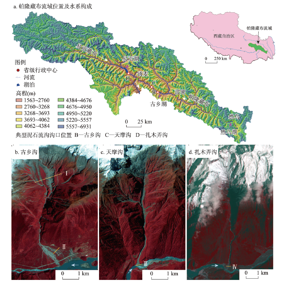
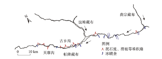
图1 帕隆藏布流域及3条典型泥石流沟示意图注:图b~c为2016年资源3号卫星影像;图d为2018年Landsat 8影像;虚线I-IV为横断面位置。 Fig. 1 The Parlung Zangbo basin and three typical debris flow gullies |
表1 古乡沟、天摩沟、扎木弄沟基本特征及典型泥石流事件Tab. 1 Characteristics and typical debris flow events in Guxiang, Tianmo and Zhamunong gullies |
| 流域面积(km2) | 主沟长度(km) | 高程 (m) | 平均纵坡(%) | 泥石流暴发 时间 | 泥石流规模(106 m3) | 成因 | 参考 文献 | |
|---|---|---|---|---|---|---|---|---|
| 古乡沟 | 25.2 | 8.7 | 6298~2530 | 25.6 | 1953.09.29 | 11 | 1950年地震引发滑坡堵塞沟谷上游形成堰塞体;1953年降雨和升温造成堰塞体溃决 | [33-35] |
| 1975 | / | 冰崩 | [33-35] | |||||
| 2005.07.30—08.06 | 0.3~0.4 | 升温及强降雨引发冰崩滑坡 | [36] | |||||
| 2020.07 | / | 降雨 | 本文 | |||||
| 天摩沟 | 17.8 | 7.1 | 5560~ 2460 | 27.2 | 2007.09.04 | ~1.0 | 升温和降雨引发冰崩/岩崩/滑坡 | [37-38] |
| 2010.07.25 | 0.1~0.5 | 强降雨和升温引发崩滑堵塞沟道,后溃决 | [37-38] | |||||
| 2010.09.03 | 0.1~0.5 | 降雨升温 | [37-38] | |||||
| 2018.07.11 | 0.18 | 升温及降雨引发岩崩 | [39] | |||||
| 扎木弄沟 | 29.4 | 9.7 | 5616~ 2186 | 27.7 | 1900 | 510 | 前期降雨和升温 | [40-41] |
| 2000.04.09 | 280~300 | 升温和降雨引起滑坡 | [42-43] | |||||
| 2015.08 | 0.06 | 降雨 | [44] | |||||
| 2020.07 | 0.01~0.1 | 降雨 | 本文 |
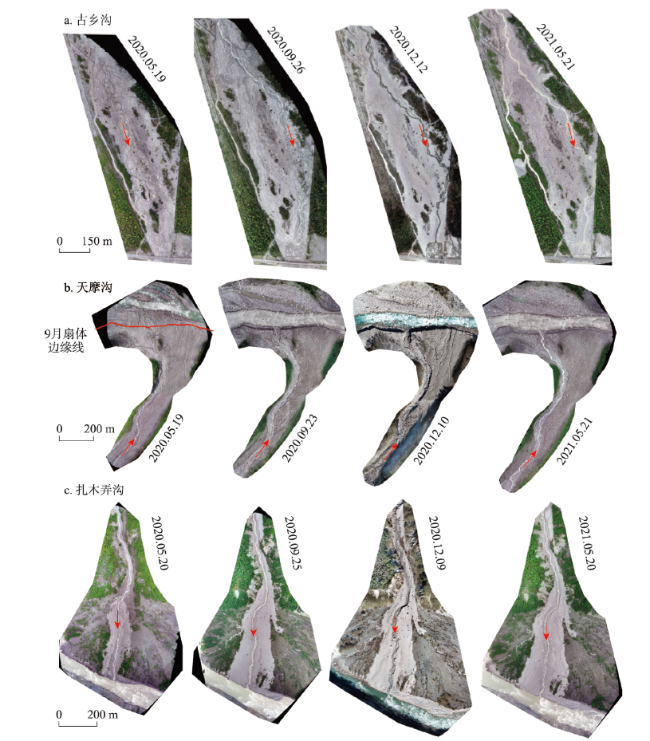
图5 基于无人机航拍数据生成的泥石流沟沟口堆积扇Fig. 5 The deposit fans of the three gullies produced based on UAV data |
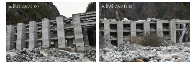
图6 古乡沟中游峡谷出口泥石流工程设施拦蓄泥石流固相(视角向沟道上游)注:余国安于2020年拍摄。 Fig. 6 Engineering works built at the canyon outlet of the Guxiang Gully to intercept sediment (facing upstream of the gully) |
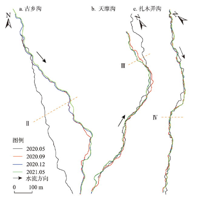
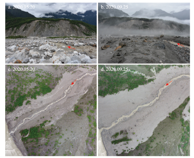
图7 3条泥石流沟出口冲积扇沟道主流线摆动情况Fig. 7 Wandering of main stream of the three gullies before and after the flood season |
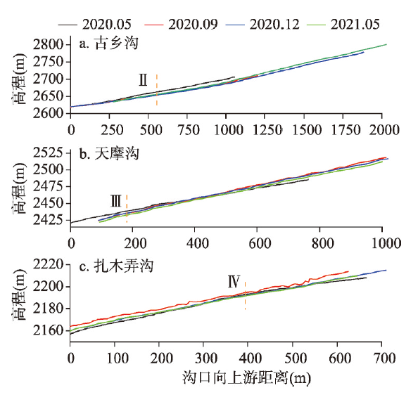
图8 沟口冲积扇主流道纵剖面冲淤变化Fig. 8 Incision/siltation of the longitudinal profile of the main streams of the three gullies at the deposit fan |
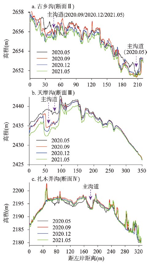
图9 汛期前后泥石流沟出口堆积扇典型横断面冲淤及主沟道摆动Fig. 9 Variation of cross sectional profiles and wandering of main stream before and after the flood season |
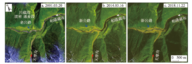
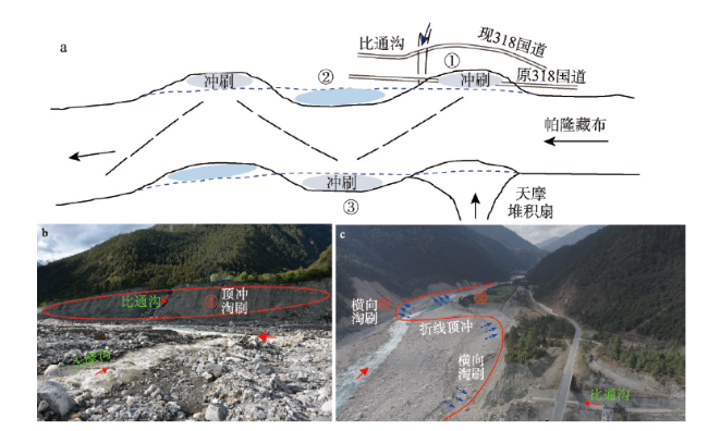
图11 天摩沟泥石流事件前后帕隆藏布河流地貌变化Fig. 11 Change of morphology of Parlung Zangbo River before and after debris flows from Tianmo Gully |
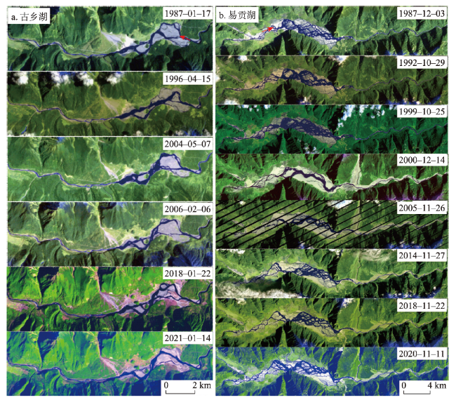
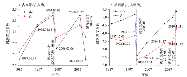
图13 1987—2021年古乡湖和易贡湖遥感影像Fig. 13 Remote sensing images of Guxiang and Yigong lakes from 1987 to 2021 |
| [1] |
|
| [2] |
|
| [3] |
|
| [4] |
|
| [5] |
|
| [6] |
|
| [7] |
|
| [8] |
|
| [9] |
|
| [10] |
|
| [11] |
[魏学利, 陈宁生. 官坝河泥石流发育特征及对四川邛海的泥沙淤积效应. 地理学报, 2018, 73(1): 81-91.]
|
| [12] |
|
| [13] |
|
| [14] |
[舒安平, 张欣, 唐川, 等. 不同坡度条件下非均质泥石流堆积过程与特征. 水利学报, 2013, 44(11): 1333-1337, 1346.]
|
| [15] |
|
| [16] |
|
| [17] |
|
| [18] |
[蒋忠信. 藏东南泥石流沟纵剖面演化的最小功模式. 地理科学, 2003, 23(1): 25-31.]
|
| [19] |
|
| [20] |
|
| [21] |
[梁馨月, 徐梦珍, 吕立群, 等. 基于地貌特征的青藏高原边缘泥石流沟分类. 地理学报, 2020, 75(7): 1373-1385.]
|
| [22] |
[崔鹏, 何易平, 陈杰. 泥石流输沙及其对山区河道的影响. 山地学报, 2006, 24(5): 539-549.]
|
| [23] |
|
| [24] |
|
| [25] |
Tibetan Plateau Scientific Expedition Team of Chinese Academy of Sciences. Rivers and Lakes in Tibet. Beijing: Science Press, 1984.
[中国科学院青藏高原综合科学考察队. 西藏河流与湖泊. 北京: 科学出版社, 1984.]
|
| [26] |
Institute of Mountain Hazards and Environment, Chinese Academy of Sciences and Ministry of Water Resources of China, Institute of the Traffic Science, Tibet Autonomous Region. A Study of Typical Mountain Hazards along Sichuan-Tibet Highway. Chengdu: Chengdu Science and Technology University Publishing House, 1999.
[中国科学院成都山地灾害与环境研究所, 西藏自治区交通科学研究所. 川藏公路典型山地灾害研究. 成都: 成都科技大学出版社, 1999.]
|
| [27] |
Mountaineering and Scientific Expedition Team of Chinese Academy of Sciences. Geology of the Namcha Barwa Aera. Beijing: Science Press, 1992.
[中国科学院登山科学考察队. 南迦巴瓦峰地区地质. 北京: 科学出版社, 1992.]
|
| [28] |
Tibetan Plateau Scientific Expedition Team of Chinese Academy of Sciences. Glaciers in Tibet. Beijing: Science Press, 1986.
[中国科学院综合科学考察队. 西藏冰川. 北京: 科学出版社, 1986.]
|
| [29] |
[尚彦军, 杨志法, 袁广祥, 等. 雅鲁藏布江大拐弯北部川藏公路地质灾害发育与分布研究. 北京: 中国铁道出版社, 2010.]
|
| [30] |
[杨威, 姚檀栋, 徐柏青, 等. 近期藏东南帕隆藏布流域冰川的变化特征. 科学通报, 2010, 55(18): 1775-1780.]
|
| [31] |
[鲁建莹, 余国安, 黄河清. 气候变化影响下高山区泥石流形成机制研究及展望. 冰川冻土, 2021, 43(2): 555-567.]
|
| [32] |
|
| [33] |
[朱平一, 罗德富, 寇玉贞. 西藏古乡沟泥石流发展趋势. 山地研究, 1997, 15(4): 296-299.]
|
| [34] |
[胡凯衡, 崔鹏, 游勇, 等. 物源条件对震后泥石流发展影响的初步分析. 中国地质灾害与防治学报, 2011, 22(1): 1-6.]
|
| [35] |
[刘建康, 程尊兰. 西藏古乡沟泥石流与气象条件的关系. 科学技术与工程, 2015, 15(9): 45-49, 55.]
|
| [36] |
[鲁安新, 邓晓峰, 赵尚学, 等. 2005年西藏波密古乡沟泥石流暴发成因分析. 冰川冻土, 2006, 28(6): 956-960.]
|
| [37] |
|
| [38] |
|
| [39] |
[高波, 张佳佳, 王军朝, 等. 西藏天摩沟泥石流形成机制与成灾特征. 水文地质工程地质, 2019, 46(5): 144-153.]
|
| [40] |
[李俊, 陈宁生, 欧阳朝军, 等. 扎木弄沟滑坡型泥石流物源及堵河溃坝可能性分析. 灾害学, 2017, 32(1): 80-84, 116.]
|
| [41] |
[朱平一, 王成华, 唐邦兴. 西藏特大规模碎屑流堆积特征. 山地学报, 2000, 18(5): 453-456.]
|
| [42] |
[殷跃平. 西藏波密易贡高速巨型滑坡特征及减灾研究. 水文地质工程地质, 2000, 27(4): 8-11.]
|
| [43] |
|
| [44] |
[王伟宇, 李俊, 赵苑迪. 降雨频率与泥石流暴发频率关系研究: 以2015年8月西藏扎木弄沟泥石流为例. 甘肃科学学报, 2020, 32(1): 60-65.]
|
| [45] |
|
| [46] |
[李炳元, 潘保田. 青藏高原古地理环境研究. 地理研究, 2002, 21(1): 61-70.]
|
/
| 〈 |
|
〉 |
