
青藏高原东北部甘加盆地古梯田地层与年代初探
|
张陈彬(1998-), 男, 浙江海宁人, 硕士生, 研究方向为全新世人—环境相互作用。E-mail: zhangchb20@itpcas.ac.cn |
收稿日期: 2021-01-04
要求修回日期: 2021-10-20
网络出版日期: 2022-03-25
基金资助
国家自然科学基金项目(42171150)
国家自然科学基金项目(41988101)
第二次青藏高原综合科学考察研究(2019QZKK0601)
中央高校基本科研业务费专项资金(lzujbky-2020-73)
版权
A preliminary study of the strata and age of ancient agricultural terraces in the Ganjia Basin, northeastern Tibetan Plateau
Received date: 2021-01-04
Request revised date: 2021-10-20
Online published: 2022-03-25
Supported by
National Natural Science Foundation of China(42171150)
National Natural Science Foundation of China(41988101)
The Second Tibetan Plateau Scientific Expedition and Research(2019QZKK0601)
The Fundamental Research Funds for the Central Universities(lzujbky-2020-73)
Copyright
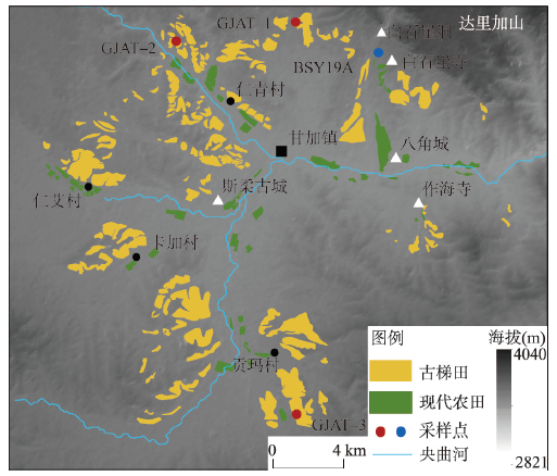
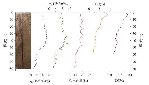
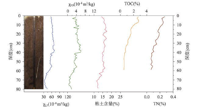
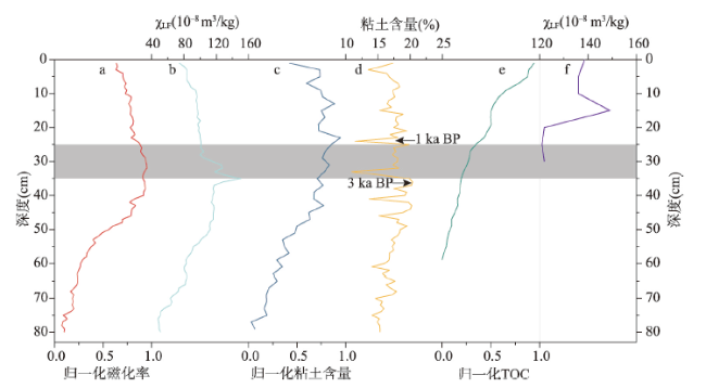
梯田是人类几千年来利用和改造自然能力的象征,在人类社会发展中发挥了重要的作用。甘加盆地位于青藏高原东北部甘肃省夏河县,盆地内的丘陵、山麓地带分布大面积的层状梯形景观,疑似弃耕的古代梯田。本文在实地考察的基础上,基于卫星遥感资料,通过GIS手段分析发现古梯田面积为42.2 km2(约63000亩),主要分布在盆地内央曲河及其支流两侧海拔2936~3326 m间的山坡上。通过对3个古梯田剖面样品的磁化率、总有机碳/氮(TOC、TN)含量、孢粉、粒度等环境代用指标分析,同时对比具有准确年代控制的自然剖面磁化率与粒度。研究结果显示:梯田开垦于晚全新世(距今3000 a)古土壤,梯田剖面顶部25~35 cm不同于自然剖面而呈均一化的指标证实了耕作层的存在(距今约1000 a以下层位);但耕作层之上TOC、TN含量的增多,以及梯田剖面与自然剖面整体一致的指标变化趋势说明了梯田被短期利用后长期废弃;结合历史文献资料推断夏河古梯田是在北宋“弓箭手屯田”制度(1074—1125年)下开垦的;气候重建资料显示该时段温度较高、降水增加,整体有益于农业生产。本文提供了过去人类社会适应气候变化的典型案例。
张陈彬 , 吴铎 , 陈雪梅 , 袁子杰 , 陈发虎 . 青藏高原东北部甘加盆地古梯田地层与年代初探[J]. 地理学报, 2022 , 77(1) : 66 -78 . DOI: 10.11821/dlxb202201005
Agricultural terraces are a manifestation of man's ability to transform nature during the past thousands of years, and they have played an important role in the development of human society. The Ganjia Basin in Xiahe County, Gansu Province, is located in the northeastern Tibetan Plateau. A large area of banded landscape is distributed on the hills and piedmonts in the Ganjia Basin, which is claimed to be composed of large-scale abandoned ancient terraces. Based on fieldwork, satellite remote sensing data and GIS analysis in the present study, we found that the ancient terraces cover an area of 42.2 km2 and are mainly distributed on slopes between 2936 and 3326 m a.m.s.l. (meters above mean sea level) on both sides of the Yangqu River and its tributaries in the basin. Additionally, we analyzed various environmental proxies, including magnetic susceptibility (MS), grain size, the contents of total organic carbon (nitrogen) (TOC, TN), and palynological assemblages, from three representative sections of ancient agricultural terraces (GJAT-1, GJAT-1, and GJAT-3), and compared them with the MS values and clay content of a natural profile with accurate chronological control in the Ganjia Basin. The results indicate that the terraces are reclaimed paleosols dating to the Late Holocene (3000 kyr BP), and that the homogeneous MS values of the top 25-35 cm of the terrace profiles differ from those of the natural soil section, which confirms the existence of a cultivation layer in the terraces. However, the increases in the contents of TOC and TN above the cultivated layer, and the fact that the trend of MS in the terrace profile is broadly in line with the natural profile, indicate that the terraces were only used for a short interval and have been abandoned for a relatively long time. Combined with historical documentary evidence, we infer that the ancient Xiahe agricultural terraces were constructed as a result of the "Gongjianshou (bowman) militia farming" policy during the Northern Song China (1074-1125 CE). Climate reconstructions for the Northern Hemisphere and northern China demonstrate that the temperature was higher and that the precipitation increased during this interval, providing a favorable environment for agricultural production. Overall, our results provide a typical example of societal adaptation to climate change in the past.
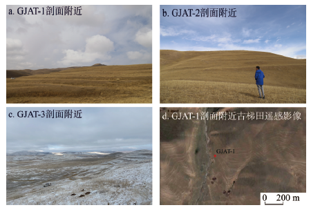
表1 夏河古梯田剖面位置信息Table 1 Location information for the profiles from the Xiahe ancient terraces |
| 剖面名称 | 位置 | 海拔(m) |
|---|---|---|
| GJAT-1 | 35°27′09.75″N, 102°31′32.93″E | 3193 |
| GJAT-2 | 35°26′41.39″N, 102°27′58.09″E | 3129 |
| GJAT-3 | 35°17′34.75″N, 102°31′34.75″E | 3184 |
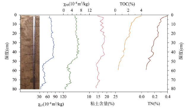
图3 GJAT-1剖面低频质量磁化率(χLF)、频率磁化率(χFD)、粘土含量、总有机碳(TOC)、总氮(TN)随地层深度变化特征Fig. 3 Low-frequency magnetic susceptibility (χLF), mass-specific frequency-dependent magnetic susceptibility (χFD), and the contents of clay, total organic carbon (TOC), and total nitrogen (TN) of the GJAT-1 profile |
图4 GJAT-2剖面质量低频磁化率(χLF)、频率磁化率(χFD)、粘土含量、总有机碳(TOC)、总氮(TN)随地层深度变化特征Fig. 4 Low-frequency magnetic susceptibility (χLF), mass-specific frequency-dependent magnetic susceptibility (χFD), and the contents of clay, total organic carbon (TOC), and total nitrogen (TN) of the GJAT-2 profile |
感谢兰州大学资源环境学院博士研究生张姚与任秀秀、中国科学院青藏高原研究所博士研究生王彦人参与孢粉与植硅体前处理实验。
| [1] |
[ 董广辉, 张山佳, 杨谊时, 等. 中国北方新石器时代农业强化及对环境的影响. 科学通报, 2016, 61(26): 2913-2925.]
|
| [2] |
|
| [3] |
|
| [4] |
|
| [5] |
|
| [6] |
|
| [7] |
|
| [8] |
|
| [9] |
|
| [10] |
|
| [11] |
Toqto. The History of Song Dynasty. Beijing: Zhonghua Book Company, 1977.
[脱脱. 宋史. 北京: 中华书局, 1977.]
|
| [12] |
[ 尚小生, 靳玉平. 甘南州夏河县天然草场植被类型特征及其分布规律. 草业与畜牧, 2012(1): 39-40.]
|
| [13] |
[ 杨延彪, 王永国, 何月芳. 夏河县高山地区草地及农田害虫的初步调查. 四川草原, 2000(1): 33-43.]
|
| [14] |
|
| [15] |
|
| [16] |
|
| [17] |
[ 洲塔, 樊秋丽. 唃厮啰遗城“雍仲卡尔”考释. 中国藏学, 2010(1): 77-83.]
|
| [18] |
[ 聂传平, 侯甬坚. 采造务、堡寨、弓箭手: 北宋对西北吐蕃居地的开发与开拓. 中国边疆史地研究, 2015, 25(1): 56-64, 180.]
|
| [19] |
[ 刘琳, 刁忠民, 舒大刚. 宋会要辑稿. 上海: 古籍出版社, 2014.]
|
| [20] |
|
| [21] |
[ 刘青松, 邓成龙. 磁化率及其环境意义. 地球物理学报, 2009, 52(4): 1041-1048.]
|
| [22] |
|
| [23] |
[ 陈慧, 杨胜利, 成婷, 等. 青藏高原东部表土磁化率特征与环境意义. 冰川冻土, 2018, 40(6): 1187-1194.]
|
| [24] |
[ 刘现彬, 夏敦胜, 贾佳, 等. 兰州九州台黄土磁性特征及其古气候意义研究. 第四纪研究, 2012, 32(4): 761-770.]
|
| [25] |
[ 张彩云, 庞奖励, 常美蓉, 等. 农业耕作土壤与人工经济林地土壤磁化率和质地特征对比. 农业系统科学与综合研究, 2009, 25(1): 91-94.]
|
| [26] |
|
| [27] |
[ 许文强, 罗格平, 陈曦, 等. 干旱区绿洲不同土地利用方式和强度对土壤粒度分布的影响. 干旱区地理, 2005, 28(6): 800-804.]
|
| [28] |
[ 刁桂仪, 文启忠. 黄土中的有机质. 地理科学, 1988, 8(3): 226-231, 295.]
|
| [29] |
[ 张俊华, 李国栋, 南忠仁, 等. 耕作历史和种植制度对绿洲农田土壤有机碳及其组分的影响. 自然资源学报, 2012, 27(2): 196-203.]
|
| [30] |
|
| [31] |
[ 饶志国, 郭文康, 薛骞, 等. 黄土高原西部地区黄土地层有机质主要来源分析. 第四纪研究, 2015, 35(4): 819-827.]
|
| [32] |
|
| [33] |
[ 许清海, 李曼玥, 张生瑞, 等. 中国第四纪花粉现代过程: 进展与问题. 中国科学: 地球科学, 2015, 45(11): 1661-1682.]
|
| [34] |
|
| [35] |
|
| [36] |
|
| [37] |
|
| [38] |
|
| [39] |
[ 李宜垠, 周力平, 崔海亭. 人类活动的孢粉指示体. 科学通报, 2008, 53(9): 991-1002.]
|
| [40] |
[ 陈蝶, 卫伟, 陈利顶. 梯田景观的历史分布及典型国际案例分析. 应用生态学报, 2017, 28(2): 689-698.]
|
| [41] |
[ 班固. 汉书. 北京: 中华书局, 1996.]
|
| [42] |
[ 安丽卿. 甘肃夏河方言音系. 兰州文理学院学报: 社会科学版, 2017, 33(4): 106-112.]
|
| [43] |
[ 石越. 论唐蕃经济交往. 西北民族大学学报: 哲学社会科学版, 2016(6): 89-95.]
|
| [44] |
[ 魏明孔. 唐代吐蕃畜牧业与农业经济初探: 以敦煌文书为主的考察. 中国经济史研究, 2013(2): 47-53, 175.]
|
| [45] |
[ 李焘. 续资治通鉴长编. 北京: 中华书局, 1980.]
|
| [46] |
[ 衣保中. 金代屯田制度初探. 北方文物, 1990, 23(3): 76-81.]
|
| [47] |
[ 李倩. 试论《元史·兵志》中关于元代屯田的漏载. 江汉论坛, 2003(12): 73-75.]
|
| [48] |
[ 李莎. 元代屯田中的人口迁移. 郑州航空工业管理学院学报: 社会科学版, 2007, 26(6): 47-48.]
|
| [49] |
[ 赵旭国. 明清时期甘南藏区农牧业开发研究[D]. 兰州: 西北师范大学, 2010.]
|
| [50] |
[ 葛全胜, 刘健, 方修琦, 等. 过去2000年冷暖变化的基本特征与主要暖期. 地理学报, 2013, 68(5): 579-592.]
|
| [51] |
|
| [52] |
[ 郑景云, 刘洋, 吴茂炜, 等. 中国中世纪气候异常期温度的多尺度变化特征及区域差异. 地理学报, 2019, 74(7): 1281-1291.]
|
| [53] |
|
| [54] |
|
| [55] |
|
/
| 〈 |
|
〉 |
