
黄河三角洲潮沟网络形态特征的时空分异规律及其发育过程
|
牟奎南(1996-), 女, 山东烟台人, 硕士生, 研究方向为遥感技术与地学应用。E-mail: moukuinan@163.com |
收稿日期: 2020-10-22
要求修回日期: 2021-05-20
网络出版日期: 2021-11-25
基金资助
国家重点研发计划(2017YFC0505903)
国家自然科学基金项目(41971381)
版权
Spatiotemporal differentiation and development process of tidal creek network morphological characteristics in Yellow River Delta
Received date: 2020-10-22
Request revised date: 2021-05-20
Online published: 2021-11-25
Supported by
National Key R&D Program of China(2017YFC0505903)
National Natural Science Foundation of China(41971381)
Copyright
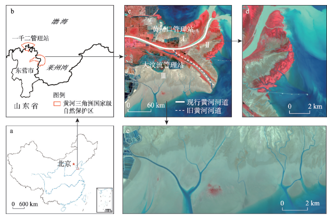
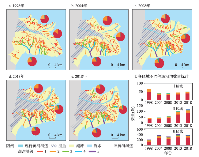
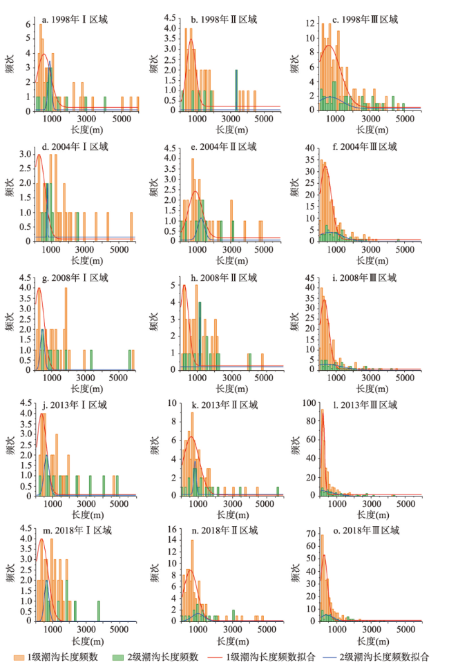
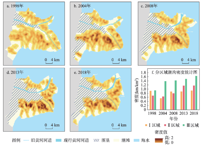
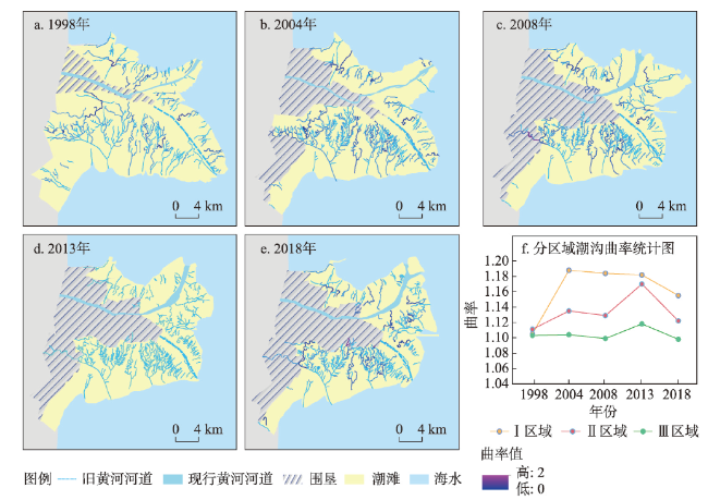
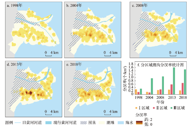
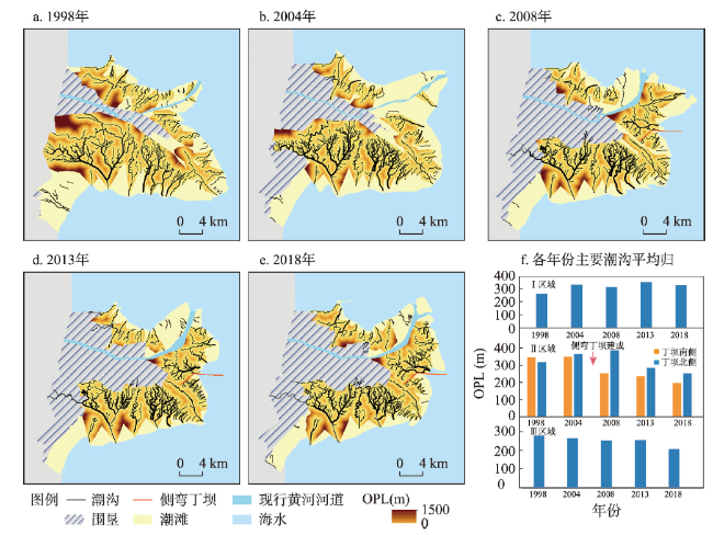
潮沟是陆海生态系统交互作用的主要通道,具有高度的时空动态性。以黄河三角洲新旧河道为界,划分黄河北岸(Ⅰ区)、南岸东(Ⅱ区)、南岸西(Ⅲ区)为对比研究区,选择1998—2018年5个关键时间节点的遥感影像为数据源,利用GIS空间分析功能,定量表征了潮沟发育程度的典型形态特征参数,剖析了黄河改道、湿地恢复工程和外来物种入侵等因子对潮沟发育过程的影响,挖掘潮沟网络的时空演变规律。结果表明:① 潮沟的形态特征具有明显的时空异质性。从1998年黄河改道初期至2004年湿地恢复初期,Ⅰ区各等级潮沟数量大幅减少;由于潮滩淤进和互花米草固滩作用,Ⅱ区潮沟数量、密度、分汊率呈现增长趋势,在2013年互花米草的快速扩张期,潮沟曲率、分汊率明显增大;Ⅲ区潮沟发育的等级、长度、密度最大,等级间的转化频率最高,湿地恢复工程导致低等级潮沟数量、长度明显减少,较强的海洋动力抑制了潮沟曲流的发育。② 黄河改道和侧弯丁坝建设导致平均归槽长度(OPL)增大,潮沟网络的排水效率减少。互花米草的快速扩张使排水效率增大,OPL不断降低;潮沟发育程度Ⅲ区>Ⅱ区>Ⅰ区。③ 潮沟系统由快速变化青年期整体进入缓慢变化中年期,发育状态趋于动态平衡。研究成果有助于了解大范围潮沟的发育过程及演变机制,为沿岸潮滩开发与利用提供科学的决策支撑。

牟奎南 , 宫兆宁 , 邱华昌 . 黄河三角洲潮沟网络形态特征的时空分异规律及其发育过程[J]. 地理学报, 2021 , 76(9) : 2312 -2328 . DOI: 10.11821/dlxb202109019
The tidal creek is the main channel for the interaction of the land-sea ecosystem and has a high degree of spatiotemporal dynamics. Taking the old and new river courses in the Yellow River Delta as the boundary, the North Bank of the Yellow River (Area I), the East of the South Bank (Area II), and the West of the South Bank (Area III) are divided into comparative study areas. Remote-sensing images of five key time nodes from 1998 to 2018 are selected as the data source. Using the GIS spatial analysis function, the typical morphological characteristics of the tidal creek development degree are quantitatively characterized. The influence of factors such as the Yellow River diversion, wetland restoration project, and alien species invasion on the development process of tidal creeks is analyzed. Mining the temporal and spatial evolution of the tidal creek network through morphological parameters. Results are shown as follows. (1) The morphological characteristics of tidal creeks have obvious spatiotemporal heterogeneity. From the early stage of the Yellow River diversion in 1998 to the early stage of wetland restoration in 2004, the number of tidal creeks at all levels in Area I decreased significantly. Owing to the siltation of tidal flats and the effect of Spartina alterniflora, the number, density, and bifurcation ratio of tidal creeks in Area II showed an increasing trend. During the rapid expansion period of Spartina alterniflora in 2013, the curvature and bifurcation ratio of the tidal creek increased significantly. The level, length, and density of tidal creek development in Area III were the highest, as is the frequency of conversion between levels. The wetland restoration project has resulted in a significant reduction in the number and length of low-grade tidal creeks. Strong ocean dynamics inhibited the development of meanders in tidal creeks. (2) The diversion of the Yellow River and construction of side-curved spur dams have led to an increase in the overmarsh path length (OPL). This reduces the drainage density of the tidal creek network The rapid expansion of Spartina alterniflora increased the drainage density and the OPL continued to decrease. The degree of tidal creek development is Area III>Area II>Area I. (3) The tidal creek system changed rapidly from adolescence to middle age, and the development tended to be in dynamic equilibrium. The research results aid an understanding of the development process and evolution mechanism of large-scale tidal creeks, and provide scientific decision support for the development and utilization of coastal tidal flats.
表1 遥感影像的基本信息Tab. 1 Essential information of remote-sensing images |
| 影像类别 | 时段 | 影像类型 | 行列号 | 成像时间 |
|---|---|---|---|---|
| 实验影像 | 1998 | TM | 121/34 | 04/19,06/06,09/26,12/15 |
| 2004 | TM | 121/34 | 03/18,05/21,09/10,10/12 | |
| 2008 | TM | 121/34 | 04/14,07/03,10/07,10/23 | |
| 2013 | OLI | 121/34 | 04/02,06/15,09/03,11/22 | |
| 2018 | OLI | 121/34 | 03/25,07/31,09/17,10/19 | |
| 验证影像 | 2013 | SPOT-6 | - | 09/03 |
| 2018 | GF-1 PMS | - | 07/16 |
| [1] |
[吕亭豫, 龚政, 张长宽, 等. 粉砂淤泥质潮滩潮沟形态特征及发育演变过程研究现状. 河海大学学报(自然科学版), 2016, 44(2): 178-188.]
|
| [2] |
|
| [3] |
[李春初. 论河口体系及其自动调整作用: 以华南河流为例. 地理学报, 1997, 52(4): 353-360.]
|
| [4] |
|
| [5] |
|
| [6] |
|
| [7] |
|
| [8] |
[陈才俊. 江苏中部海堤大规模外迁后的潮水沟发育. 海洋通报, 2001, 20(6): 71-79.]
|
| [9] |
[沈永明, 张忍顺, 王艳红. 互花米草盐沼潮沟地貌特征. 地理研究, 2003, 22(4): 520-527.]
|
| [10] |
[吴德力, 沈永明, 方仁建. 江苏中部海岸潮沟的形态变化特征. 地理学报, 2013, 68(7): 955-965.]
|
| [11] |
|
| [12] |
[龚政, 张岩松, 赵堃, 等. 风暴作用下淤泥质潮滩—潮沟系统地貌演变研究进展. 水利水电科技进展, 2019, 39(4): 75-84.]
|
| [13] |
[李加林, 杨晓平, 童亿勤. 潮滩围垦对海岸环境的影响研究进展. 地理科学进展, 2007, 26(2): 43-51.]
|
| [14] |
|
| [15] |
[张磊, 宫兆宁, 王启为, 等. Sentinel-2影像多特征优选的黄河三角洲湿地信息提取. 遥感学报, 2019, 23(2): 313-326.]
|
| [16] |
|
| [17] |
|
| [18] |
|
| [19] |
|
| [20] |
|
| [21] |
[燕守广. 江苏淤长型淤泥质潮滩上潮沟的发育与演变[D]. 南京: 南京师范大学, 2002.]
|
| [22] |
|
| [23] |
|
| [24] |
|
| [25] |
[刘红玉, 吕宪国, 刘振乾. 环渤海三角洲湿地资源研究. 自然资源学报, 2001, 16(2): 101-106.]
|
| [26] |
[彭俊, 陈沈良. 近60年黄河水沙变化过程及其对三角洲的影响. 地理学报, 2009, 64(11): 1353-1362.]
|
| [27] |
[王启为, 宫兆宁, 关鸿亮, 等. 异质背景下黄河三角洲潮沟的遥感提取方法. 应用生态学报, 2019, 30(9): 3097-3107.]
|
| [28] |
|
| [29] |
[王青, 骆梦, 邱冬冬, 等. 滨海盐沼水文特征对盐地碱蓬定植过程的影响. 自然资源学报, 2019, 34(12): 2569-2579.]
|
| [30] |
|
| [31] |
[单凯. 黄河三角洲自然保护区湿地生态恢复的原理、方法与实践. 湿地科学与管理, 2007, 3(4): 16-20.]
|
| [32] |
[武亚楠, 王宇, 张振明. 黄河三角洲潮沟形态特征对湿地植物群落演替的影响. 生态科学, 2020, 39(1): 33-41.]
|
| [33] |
|
| [34] |
|
| [35] |
|
| [36] |
|
| [37] |
[于小娟, 张仲胜, 薛振山, 等. 1989年以来7个时期黄河三角洲潮沟的形态特征及连通性研究. 湿地科学, 2018, 16(4): 517-523.]
|
| [38] |
[黄海军, 樊辉. 黄河三角洲潮滩潮沟近期变化遥感监测. 地理学报, 2004, 59(5): 723-730.]
|
| [39] |
|
| [40] |
[任美锷, 张忍顺, 杨巨海, 等. 风暴潮对淤泥质海岸的影响: 以江苏省淤泥质海岸为例. 海洋地质与第四纪地质, 1983, 3(4): 1-24.].
|
| [41] |
|
| [42] |
[王爱军, 高抒, 贾建军. 互花米草对江苏潮滩沉积和地貌演化的影响. 海洋学报, 2006, 28(1): 92-99.]
|
| [43] |
[刘建华, 杨世伦, 史本伟, 等. 长江口崇明东滩潮沟地貌形态和演变. 海洋学研究, 2012, 30(2): 43-50.]
|
| [44] |
|
| [45] |
|
| [46] |
|
| [47] |
|
| [48] |
|
| [49] |
[陈勇, 何中发, 黎兵, 等. 崇明东滩潮沟发育特征及其影响因素定量分析. 吉林大学学报(地球科学版), 2013, 43(1): 212-219.]
|
| [50] |
|
| [51] |
|
| [52] |
[路兵, 蒋雪中. 滩涂围垦对崇明东滩演化影响的遥感研究. 遥感学报, 2013, 17(2): 342-349, 335.]
|
| [53] |
[李建国, 濮励杰, 徐彩瑶, 等. 1977—2014年江苏中部滨海湿地演化与围垦空间演变趋势. 地理学报, 2015, 70(1): 17-28.]
|
| [54] |
|
| [55] |
[杜景龙, 杨世伦, 张文祥, 等. 长江口北槽深水航道工程对九段沙冲淤影响研究. 海洋工程, 2005, 23(3): 78-83.]
|
/
| 〈 |
|
〉 |
