
信息地理学学科体系与发展战略要点
收稿日期: 2021-04-13
要求修回日期: 2021-08-27
网络出版日期: 2021-11-25
基金资助
国家自然科学基金项目(41988101)
版权
Disciplinary structure and development strategy ofinformation geography in China
Received date: 2021-04-13
Request revised date: 2021-08-27
Online published: 2021-11-25
Supported by
National Natural Science Foundation of China(41988101)
Copyright
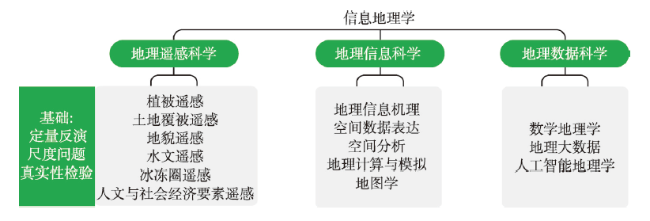
信息时代的到来极大地促进了地理科学的发展,地理科学的研究已从传统的自然地理空间、人文地理空间拓展到了信息地理空间,催生了信息地理学的发展,并逐渐形成了地理遥感科学、地理信息科学和地理数据科学3个分支学科。在《中国学科及前沿领域发展战略研究(2021—2035)》地理科学的学科规划背景下,本文梳理了信息地理学的形成、定义和学科体系,重点阐述了信息地理学的学科发展战略布局、优先领域发展目标和重点方向。以期本文有助于促进遥感、地理信息科学与技术的发展和应用回归地理科学,进一步强化地理科学研究,使其更加系统化、科学化和现代化,促进地理科学的整体发展。

李新 , 袁林旺 , 裴韬 , 黄昕 , 刘广 , 郑东海 . 信息地理学学科体系与发展战略要点[J]. 地理学报, 2021 , 76(9) : 2094 -2103 . DOI: 10.11821/dlxb202109004
The arrival of the information era has exceptionally advanced the development of geographic science. The research scope of the discipline has expanded from the space of traditional physical and human geography to the space of information geography. Meanwhile, the discipline gradually formed three subdisciplines, i.e., geographic remote sensing science, geographic information science, and geographic data science. In the context of preparing the disciplinary structure of geographic science of the "Development Strategy of Discipline and Frontier Research in China (2021-2035)", this paper summarized the history, definition, and disciplinary structure of information geography. Additionally, it highlighted the strategic layout of the discipline, as well as the goals and key directions of its priority development fields. We expect this paper to provide insight into the new discipline that could help promote the developments and applications of remote sensing and geographic information within the framework of geographic science, strengthening the synthesis of geographic research and promoting the integrated development of geographic science.
表1 信息地理学、地理信息科学、遥感与地理信息科学等学科名称对比Tab. 1 Comparisons of the concept and definition of Information Geography, Geographic Information Science (GIScience), and Remote Sensing (RS) and GIScience |
| 学科名称 | 优点 | 缺点 |
|---|---|---|
| 信息地理学 | 和自然地理、人文地理对应,把地理学的技术——遥感、GIS、地理大数据、表层地球系统科学模拟进行统一 | 有把信息的空间关系作为唯一研究对象的歧义 |
| 地理信息科学 | 学界广泛接受 | 对遥感涵盖不多,也基本不涉及地球表层系统科学的模拟,偏重于地理信息系统和地图学 |
| 遥感与地理信息科学 | 同时涵盖遥感和地理信息科学 | 学科名称太长,遥感不全是地理科学研究范畴,如传感器、大气、海洋遥感等 |
成文过程中得到陈发虎、郭华东、龚健雅、闾国年、黎夏、刘瑜、张兵、葛咏、刘良云等学者的帮助和建议,在此表示感谢。
| [1] |
[陈发虎, 李新, 吴绍洪, 等. 我国地理科学学科体系浅析. 地理学报, 2021, 76(9): 2069-2073.]
|
| [2] |
|
| [3] |
[李召良, 段四波, 唐伯惠, 等. 热红外地表温度遥感反演方法研究进展. 遥感学报, 2016, 20(5): 899-920.]
|
| [4] |
|
| [5] |
|
| [6] |
[李小文, 王祎婷. 定量遥感尺度效应刍议. 地理学报, 2013, 68(9): 1163-1169.]
|
| [7] |
[刘良云. 植被定量遥感原理与应用. 北京: 科学出版社, 2014.]
|
| [8] |
[陈军, 陈晋. GlobeLand30遥感制图创新与大数据分析. 中国科学: 地球科学, 2018, 48(10): 1391-1392.]
|
| [9] |
[李新, 车涛, 李新武, 等. 冰冻圈遥感学. 北京: 科学出版社, 2020.]
|
| [10] |
[徐冠华, 柳钦火, 陈良富, 等. 遥感与中国可持续发展: 机遇和挑战. 遥感学报, 2016, 20(5): 679-688.]
|
| [11] |
|
| [12] |
|
| [13] |
[周成虎, 程维明. 《中华人民共和国地貌图集》的研究与编制. 地理研究, 2010, 29(6): 970-979.]
|
| [14] |
|
| [15] |
|
| [16] |
[龚健雅, 夏宗国. 矢量与栅格集成的三维数据模型. 武汉测绘科技大学学报, 1997, 22(1): 7-15.]
|
| [17] |
[龚健雅. GIS中面向对象时空数据模型. 测绘学报, 1997, 26(4): 289-298.]
|
| [18] |
[闾国年. 地理分析导向的虚拟地理环境: 框架、结构与功能. 中国科学: 地球科学, 2011, 41(4): 549-561.]
|
| [19] |
[陈军, 郭薇. 三维空间实体间拓扑关系的矩阵描述. 武汉测绘科技大学学报, 1998, 23(4): 359-363.]
|
| [20] |
[王劲峰, 徐成东. 地理探测器: 原理与展望. 地理学报, 2017, 72(1): 116-134.]
|
| [21] |
[黎夏, 李丹, 刘小平. 地理模拟优化系统(GeoSOS)及其在地理国情分析中的应用. 测绘学报, 2017, 46(10): 1598-1608.]
|
| [22] |
[李德仁, 姚远, 邵振峰. 智慧城市中的大数据. 武汉大学学报·信息科学版, 2014, 39(6): 631-640.]
|
| [23] |
[龚健雅, 张翔, 向隆刚, 等. 智慧城市综合感知与智能决策的进展及应用. 测绘学报, 2019, 48(12): 1482-1497.]
|
| [24] |
[裴韬, 刘亚溪, 郭思慧, 等. 地理大数据挖掘的本质. 地理学报, 2019, 74(3): 586-598.]
|
| [25] |
[周成虎. 全空间地理信息系统展望. 地理科学进展, 2015, 34(2): 129-131.]
|
| [26] |
[周成虎, 朱欣焰, 王蒙, 等. 全息位置地图研究. 地理科学进展, 2011, 30(11): 1331-1335.]
|
| [27] |
[闾国年, 俞肇元, 袁林旺, 等. 地图学的未来是场景学吗? 地球信息科学学报, 2018, 20(1): 1-6.]
|
| [28] |
|
| [29] |
[郭华东. 地球大数据科学工程. 中国科学院院刊, 2018, 33(8): 818-824.]
|
| [30] |
|
| [31] |
|
| [32] |
|
| [33] |
|
| [34] |
|
| [35] |
|
| [36] |
|
| [37] |
|
/
| 〈 |
|
〉 |