
中国暴雨洪涝灾情时空格局及影响因素
|
胡畔(1994-), 女, 湖北荆门人, 硕士生, 研究方向为洪水灾害。E-mail: hupan@mail.bnu.edu.cn |
收稿日期: 2019-08-07
要求修回日期: 2021-04-29
网络出版日期: 2021-07-25
基金资助
国家重点研发计划(2016YFA0602404)
国家自然科学基金项目(41621061)
版权
Spatiotemporal patterns and influencing factors of rainstorm-induced flood disasters in China
Received date: 2019-08-07
Request revised date: 2021-04-29
Online published: 2021-07-25
Supported by
National Key Research and Development Program(2016YFA0602404)
National Natural Science Foundation of China(41621061)
Copyright
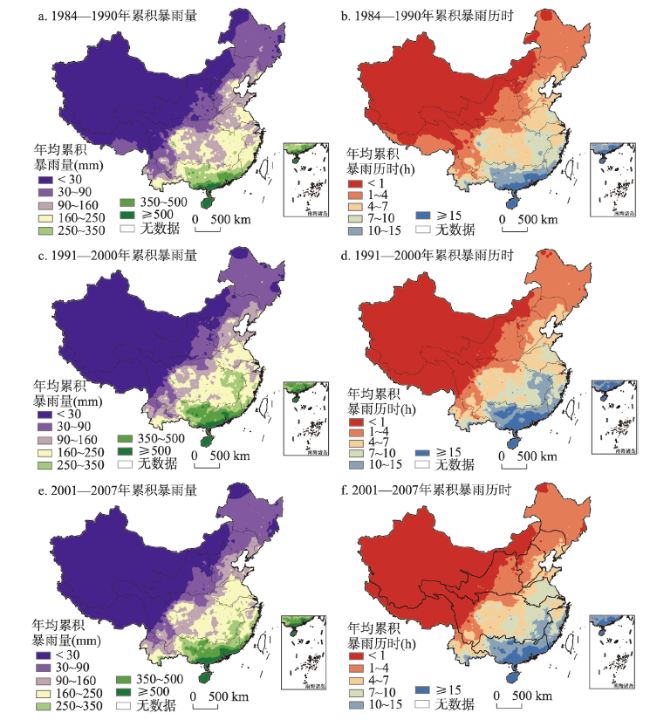
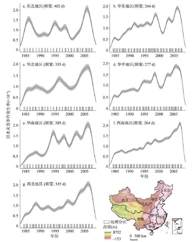
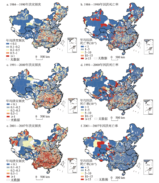
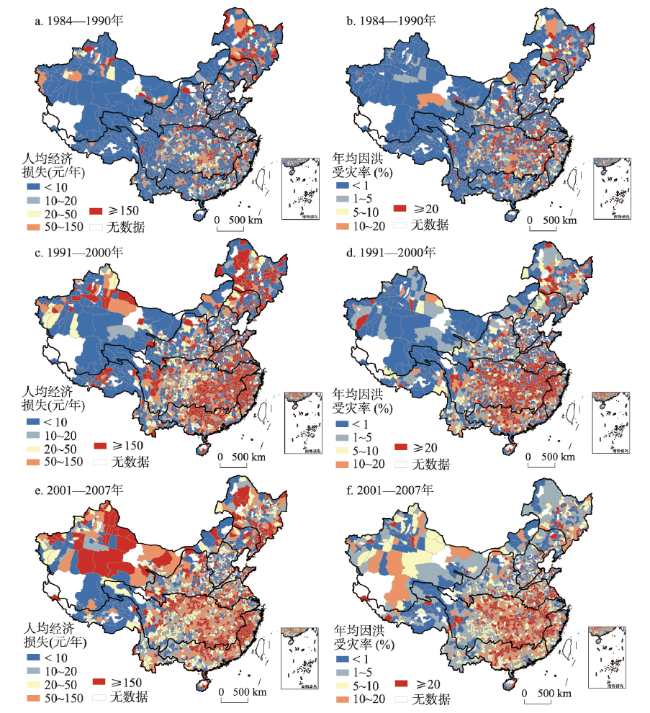
暴雨洪涝灾害给中国造成了巨大人口和经济损失。本文通过对中国气象灾情普查数据的分析,结合小时降水数据、统计年鉴等资料,研究了1984—2007年间中国极端降水和暴雨洪涝灾情时空分异特征。在此基础上,采用地理探测器研究了中国暴雨洪涝灾情时空格局的影响因素。结果表明,研究时段内全国极端降雨指标没有一致的变化趋势。长江、珠江及东南沿海等流域暴雨洪涝频次显著增加,但因灾人口死亡率下降,表明设防能力的提升对人口损失的缓减影响明显;西北地区因灾死亡人数和人口受灾率、经济损失等均增加,表明设防能力薄弱;因暴雨洪涝受灾人口贡献率最高的因子是气象致灾因素,又因暴雨洪涝死亡人口贡献率最高的是地理等孕灾环境和社会经济等承灾体因素,故暴雨洪涝直接经济损失贡献率最高的是地理等孕灾环境因素。该研究可为洪水灾情的影响因素定量化分析提供理论参考。
胡畔 , 陈波 , 史培军 . 中国暴雨洪涝灾情时空格局及影响因素[J]. 地理学报, 2021 , 76(5) : 1148 -1162 . DOI: 10.11821/dlxb202105008
Understanding the influencing factors and controls of rainstorm-induced floods, which have caused tremendous losses of human lives and national economy, is a pressing need for flood risk management in China. Based on the meteorological disaster census data of counties in China, hourly precipitation data at 2420 stations, statistical yearbook, terrain data and other data, the authors (1) investigated the spatiotemporal pattern of flood impacts in China over the period from 1984 to 2007 using trend analysis techniques and (2) explored the driving factors of the spatiotemporal pattern by adopting the geospatial statistical analysis tool (Geodetector). This study considered the spatiotemporal patterns and their interplays among county-level flood impacts (i.e., flood-induced mortality rate, proportion of population affected, and economic loss in percentage), disaster-formative environmental factors (i.e., population density, urban population percentages, average elevation, river density, average slope, and average distance to the seashore), and extreme precipitation characteristics (i.e., annual average volume and duration of extreme rainfall). The results show that: (1) there were no consistent temporal trends of extreme rainfall characteristics over the study period across China. (2) The frequencies of flood disasters in the Yangtze and Pearl rivers and southeast coastal areas increased significantly, but the casualties over these regions decreased. (3) Flood-induced casualties, proportion of population affected and economic loss in percentage increased in Northwest China; and meteorological factors, disaster-formative environment factors such as geographical conditions and social economy, and geographical conditions contribute mostly to the proportion of population affected, flood-induced death and economic loss in percentage. These results indicate that more attention should be paid to improving the flood control capacity of small or medium-sized cities in the inland river basins, especially in Northwest China, and we should recognize the important roles that disaster-formative environment plays in triggering flood losses.
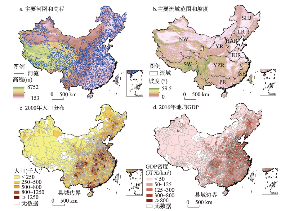
图1 中国主要河网和高程、流域范围和坡度、人口分布与GDP密度注:基于自然资源部标准地图服务网站审图号为GS(2019)1786号的标准地图制作,底图无修改;图b中缩写NW为西北内陆河流域、SW为西南诸河流域、YR为黄河流域,YZR为长江流域、PR为珠江流域、SE为东南诸河流域、HUR为淮河流域、HAR为海河流域、LR为辽河流域、SHJ为松花江流域。 Fig. 1 Spatial distribution of river streams, elevation, major river basins, slope, population and GDP in China |
图6 中国县域不同时段洪灾频次和因洪人口死亡率注:基于自然资源部标准地图服务网站审图号为GS(2019)1786号的标准地图制作,底图无修改。 Fig. 6 Annual frequency of flood events and flood-induced mortality rate in counties of China |
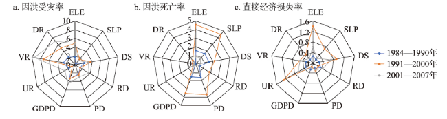
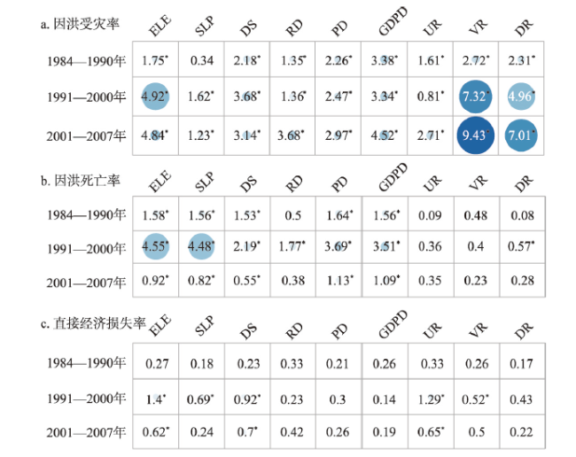
图8 气象及社会经济因素对中国暴雨洪水灾情的贡献率雷达图Fig. 8 Radar diagram of the contributions of meteorological and socio-economic variables |
| [1] |
|
| [2] |
|
| [3] |
|
| [4] |
[ 史培军, 王静爱, 周俊华, 等. 中国水灾风险综合管理: 平衡大都市区水灾致灾强度与脆弱性. 自然灾害学报, 2004,13(4):1-7.]
|
| [5] |
|
| [6] |
|
| [7] |
|
| [8] |
|
| [9] |
|
| [10] |
|
| [11] |
|
| [12] |
|
| [13] |
|
| [14] |
|
| [15] |
[ 王静爱, 毛佳, 贾慧聪. 中国水旱灾害危险性的时空格局研究. 自然灾害学报, 2008,17(1):115-121.]
|
| [16] |
[ 於琍, 徐影, 张永香. 近25 a中国暴雨及其引发的暴雨洪涝灾害影响的时空变化特征. 暴雨灾害, 2018,37(1):67-72.]
|
| [17] |
[ 史培军. 三论灾害研究的理论与实践. 自然灾害学报, 2002,11(3):1-9.]
|
| [18] |
|
| [19] |
|
| [20] |
EM-DAT: The CRED/OFDA International Disaster Database. [2017/12/10]. www.emdat.be.
|
| [21] |
|
| [22] |
Public Security Administration of the Ministry of Public Security of the People's Republiic of China. National Population Statistics by County and City of People's Republic of China. Beijing: Public Publishing House, 2014.
[ 公安部治安管理局. 中华人民共和国全国分县市人口统计资料. 北京:群众出版社, 2014.]
|
| [23] |
Department of Rural Socio-Economic Survey,National Bureau of Statistics. China County and City Social and Economic Statistics Yearbook. Beijing: China Statistics Press, 2004.
[ 国家统计局农村社会经济调查司. 中国县市社会经济统计年鉴. 北京:中国统计出版社, 2004.]
|
| [24] |
The Global Land One-kilometer Base Elevation (GLOBE)Digital Elevation Model, Version 1.0. National Oceanic and Atmospheric Administration, National Geophysical Data Center. 1999. www.ngdc.noaa.gov/mgg/topo/globe.html.
|
| [25] |
|
| [26] |
|
| [27] |
|
| [28] |
|
| [29] |
|
| [30] |
|
| [31] |
|
| [32] |
|
| [33] |
|
| [34] |
|
| [35] |
|
| [36] |
|
| [37] |
|
| [38] |
|
| [39] |
|
| [40] |
[ 王劲峰, 徐成东. 地理探测器: 原理与展望. 地理学报, 2017,72(1):116-134.]
|
| [41] |
|
| [42] |
|
| [43] |
|
| [44] |
[ 李华威, 万庆. 小流域山洪灾害危险性分析之降雨指标选取的初步研究. 地球信息科学学报, 2017,19(3):425-435.]
|
| [45] |
[ 熊俊楠, 赵云亮, 程维明, 等. 四川省山洪灾害时空分布规律及其影响因素研究. 地球信息科学学报, 2018,20(10):1443-1456.]
|
| [46] |
[ 刘业森, 杨振山, 黄耀欢, 等. 建国以来中国山洪灾害时空演变格局及驱动因素分析. 中国科学: 地球科学, 2019,49(2):408-420.]
|
| [47] |
[ 王思梦. 中国暴雨山洪时空分布规律及其驱动因素研究[D]. 西安: 西北大学, 2019.]
|
| [48] |
[ 刘业森. 中国山洪灾害时空分布格局及驱动力异质性评价研究[D]. 天津: 天津大学, 2017.]
|
| [49] |
|
| [50] |
|
| [51] |
|
| [52] |
|
/
| 〈 |
|
〉 |