
中国村庄空间分布规律及其影响因素
|
周扬(1984-), 男, 贵州普安人, 副研究员, 硕士生导师, 主要从事贫困地理与乡村振兴研究。E-mail: zhouyang@igsnrr.ac.cn |
收稿日期: 2020-01-11
要求修回日期: 2020-07-20
网络出版日期: 2020-12-25
基金资助
中国科学院战略性先导科技专项(XDA23070300)
国家自然科学基金项目(41931293)
国家自然科学基金项目(41871183)
国家自然科学基金项目(41601172)
版权
The spatial distribution characteristics and influencing factors of Chinese villages
Received date: 2020-01-11
Request revised date: 2020-07-20
Online published: 2020-12-25
Supported by
Strategic Priority Research Program of the Chinese Academy of Sciences(XDA23070300)
National Natural Science Foundation of China(41931293)
National Natural Science Foundation of China(41871183)
National Natural Science Foundation of China(41601172)
Copyright
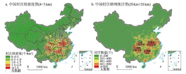
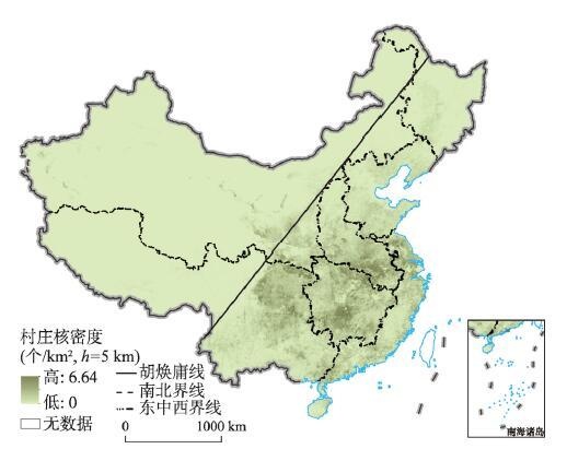
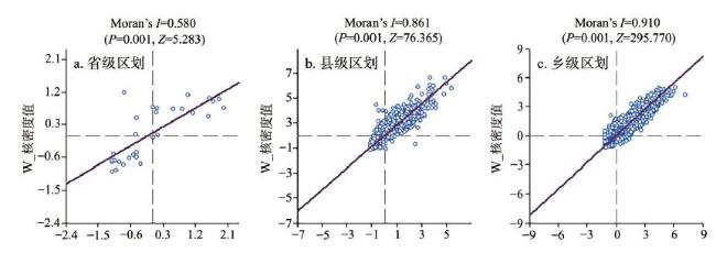
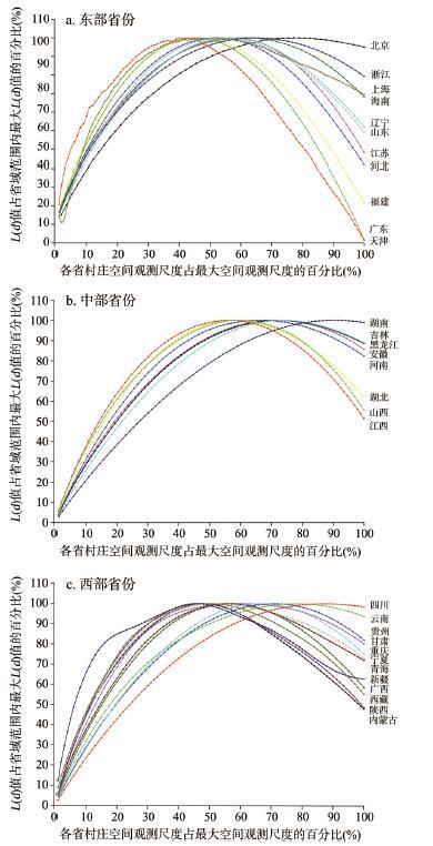
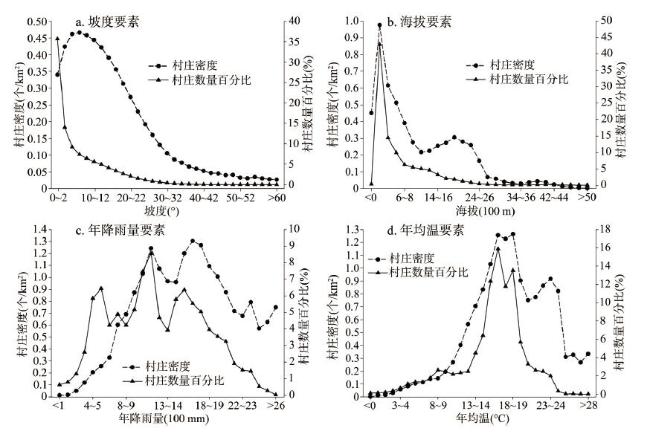
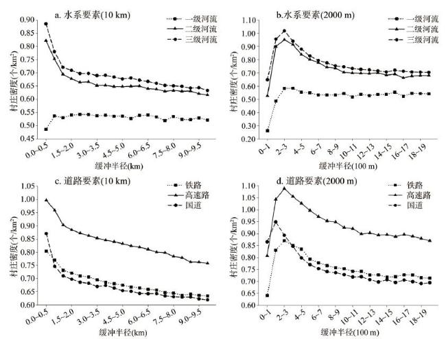
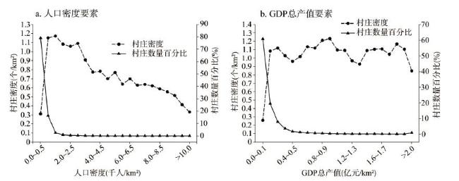
村庄是乡村治理和乡村振兴的基本单元,开展村庄空间分布特征及其影响因素研究对全面推进乡村振兴国家战略落地具有重要的理论价值和实践意义。本文在解析村庄系统演进生命周期规律的基础上,系统集成村庄点位、地理环境、地理区位、交通条件、社会经济等多源数据,综合运用缓冲区分析、核密度估计、空间自相关分析、Ripley's K函数等方法,刻画了中国村庄空间分布特征,识别了村庄空间分异的影响因子,揭示了中国村庄的空间分异规律。结果表明:① 村庄的演进遵循形成、发展、稳定、衰退与振兴的“生命周期”规律,其演进受自然地理环境和人文社会经济要素共同影响,不同地区村庄演进的速度、强度、方向和结果各异。② 中国村庄分布密度为0.35个/km 2,整体上呈现“南多北少、南聚北散”、“东多西少、东聚西散”的特征,以长江中下游及淮河流域等地区村庄分布最为密集。以“胡焕庸”线为界,东南半壁村庄密度显著高于西北半壁。③ 全国省、县、乡级尺度上村庄核密度值的莫兰指数分别为0.58、0.86、0.91,呈现明显的空间聚集特征;各省内村庄空间分布呈倒“U”型分布模式,不同省份村庄空间分布模式差异明显。④ 中国村庄分布格局是地理环境、区位条件、社会经济要素交互耦合作用的结果。在坡度6°~8°、海拔0~200 m、降雨量1100~1200 mm、年均温15~19 ℃、人为土和栽培植被等条件下村庄分布较为集聚,且村庄沿道路与河流聚集分布特征明显,在沿道路和河流100~300 m缓冲区内村庄密度最大,随缓冲距离增加村庄密度逐渐降低。全面推进乡村振兴战略背景下,亟待系统开展乡村衰退成因与动力机制解析、衰退乡村地理空间识别与地域类型划分、乡村振兴可行途径与地域模式研究。

周扬 , 黄晗 , 刘彦随 . 中国村庄空间分布规律及其影响因素[J]. 地理学报, 2020 , 75(10) : 2206 -2223 . DOI: 10.11821/dlxb202010012
Village is the object of rural governance and revitalization. It is of great scientific value to carry out the research on the spatial distribution characteristics and influencing factors for comprehensively promoting the implementation of the rural revitalization strategy. This study systematically integrated the multi-source data such as the longitude and latitude coordinates of the village, geo-environment, traffic conditions and socio-economic level, and comprehensively applied spatial analysis, kernel density estimation and Ripley's K-function to describe the spatial distribution characteristics of Chinese villages and identify the influencing factors of village spatial differentiation. The results demonstrated that the evolution of villages follows the life cycle laws of formation, development, stability, decline, and revitalization, which is affected by the natural geographical environment and human, social, and economic factors. The speed, intensity, direction, and outcome of village evolution vary across regions over time. Further analysis results showed that the distribution density of villages in China is 0.353 per square kilometer. Overall, the number of villages in China is larger in the south than in the north, and larger in the east than in the west, and characterized by agglomeration in the southeast and dispersion in the northwest. Villages are most densely distributed in the middle and lower reaches of the Yangtze River and the Huaihe River Basin. With Hu's line as the boundary, the density of villages in the southeast is higher than that in the northwest. The Moran indexes of the kernel density of villages on the scales of province, county and township are 0.580, 0.861 and 0.910, respectively, showing obvious spatial aggregation characteristics. The spatial distribution of villages in each province presents an inverted U-shaped pattern, and the difference is obvious between provinces. The distribution pattern of Chinese villages is the result of the interactive coupling of geographical environment, location conditions, and social and economic factors. The spatial distribution of Chinese villages is relatively concentrated under the conditions of a slope of 6°-8°, an altitude of less than 200 m, rainfall of 1100-1200 mm, average annual temperature of 15-19 ℃, and anthropogenic soil and cultivated vegetation. The spatial distribution of villages is clustered along roads and rivers. The density of villages in the buffer zone of 100-300 m around roads and rivers is the largest, and gradually decreases as the buffer distance increases. Under the background of comprehensively promoting the strategy of rural revitalization, it is urgent to systematically analyze the causes and dynamic mechanism of rural recession, identify the geographical distribution and types of declining villages, and explore the feasible ways and regional models of rural revitalization.
图1 中国村庄空间分布特征注:基于自然资源部标准地图服务网站审图号为GS(2019)1698号的标准地图制作,底图无修改。 Fig. 1 Spatial distribution characteristics of Chinese villages |
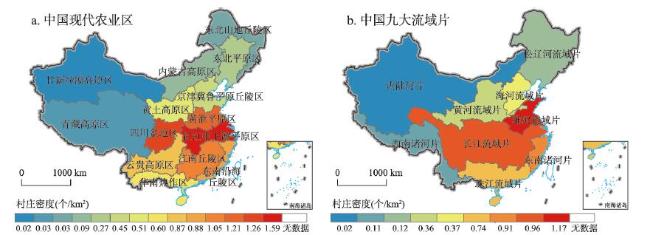
表1 不同土壤和植被类型下中国村庄统计结果Tab. 1 Statistical results of Chinese villages under different soil and vegetation types |
| 土纲分类 | 数量百分比(%) | 村庄密度(个/km2) | 植被类型 | 数量百分比(%) | 村庄密度(个/km2) |
|---|---|---|---|---|---|
| 淋溶土 | 11.818 | 0.370 | 针叶林 | 14.078 | 0.591 |
| 半淋溶土 | 5.141 | 0.403 | 针阔叶混交林 | 0.013 | 0.019 |
| 钙层土 | 2.152 | 0.122 | 阔叶林 | 5.722 | 0.276 |
| 干旱土 | 0.361 | 0.039 | 灌丛 | 14.126 | 0.531 |
| 漠土 | 0.168 | 0.009 | 荒漠 | 0.363 | 0.010 |
| 初育土 | 20.513 | 0.421 | 草原 | 1.961 | 0.046 |
| 半水成土 | 10.442 | 0.461 | 草丛 | 6.082 | 0.686 |
| 水成土 | 0.120 | 0.027 | 草甸 | 1.224 | 0.040 |
| 盐碱土 | 0.306 | 0.060 | 沼泽 | 0.092 | 0.048 |
| 人为土 | 22.549 | 1.564 | 高山植被 | 0.006 | 0.001 |
| 高山土 | 0.666 | 0.011 | 栽培植被 | 55.838 | 0.897 |
| 铁铝土 | 25.766 | 0.776 | 其他 | 0.495 | 0.025 |
| [1] |
[ 金其铭 . 我国农村聚落地理研究历史及近今趋向. 地理学报, 1988,43(4):311-317.]
|
| [2] |
Urban and Rural Planning Term Review Committee. Chinese Terms in Urban and Rural Planning. Beijing: Science Press, 2020.
[ 城乡规划学名词审定委员会. 城乡规划学名词. 北京: 科学出版社, 2020.]
|
| [3] |
[ 刘彦随, 周扬, 李玉恒 . 中国乡村地域系统与乡村振兴战略, 地理学报, 2019,74(12):2511-2528.]
|
| [4] |
[ 李红波, 张小林 . 国外乡村聚落地理研究进展及近今趋势. 人文地理, 2012,27(4):103-108.]
|
| [5] |
[
[ 金其铭, 董昕, 张小林 . 乡村地理学. 南京: 江苏教育出版社, 1990.]
|
| [6] |
[ 沃尔特·克里斯塔勒 . 德国南部的中心地原理. 常正义, 等, 译. 北京: 商务印书馆, 1998.]
|
| [7] |
|
| [8] |
|
| [9] |
|
| [10] |
|
| [11] |
|
| [12] |
|
| [13] |
|
| [14] |
|
| [15] |
[ 林超 . 聚落分类之讨论. 地理, 1938,6(1):17-18.]
|
| [16] |
[ 吴传钧 . 人地关系与经济布局: 吴传钧文集. 北京: 学苑出版社, 2008.]
|
| [17] |
[ 金其铭 . 中国农村聚落地理. 南京: 江苏科学技术出版社, 1989.]
|
| [18] |
[ 张佰林, 张凤荣, 周建 , 等. 农村居民点功能演变的微尺度分析: 山东省沂水县核桃园村的实证. 地理科学, 2015,35(10):1272-1279.]
|
| [19] |
[ 马雯秋, 何新, 姜广辉 , 等. 基于土地功能的农村居民点内部用地结构分类. 农业工程学报, 2018,34(4):269-277.]
|
| [20] |
[ 张天柱, 张凤荣, 谢臻 , 等. 精准扶贫背景下云南少数民族山区农村居民点空间格局演变. 农业工程学报, 2019,35(9):246-254.]
|
| [21] |
[ 海贝贝, 李小建, 许家伟 . 巩义市农村居民点空间格局演变及其影响因素. 地理研究, 2013,32(12):2257-2269.]
|
| [22] |
[ 谭雪兰, 钟艳英, 段建南 , 等. 快速城市化进程中农村居民点用地变化及驱动力研究: 以长株潭城市群为例. 地理科学, 2014,34(3):309-315.]
|
| [23] |
[ 高小琛, 石培基, 潘竟虎 , 等. 基于耦合关系的干旱绿洲区农村居民点整理分区研究: 以张掖市甘州区为例. 地球科学进展, 2011,26(10):1071-1078.]
|
| [24] |
[ 曲衍波, 张凤荣, 宋伟 , 等. 农村居民点整理潜力综合修正与测算: 以北京市平谷区为例. 地理学报, 2012,67(4):490-503.]
|
| [25] |
[ 杨忍, 刘彦随, 陈秧分 . 中国农村空心化综合测度与分区. 地理研究, 2012,31(9):1697-1706.]
|
| [26] |
[ 龙花楼, 李裕瑞, 刘彦随 . 中国空心化村庄演化特征及其动力机制. 地理学报, 2009,64(10):1203-1213.]
|
| [27] |
[ 刘彦随, 刘玉, 翟荣新 . 中国农村空心化的地理学研究与整治实践. 地理学报, 2009,64(10):1193-1202.]
|
| [28] |
[ 谭雪兰, 于思远, 欧阳巧玲 , 等. 快速城市化区域农村空心化测度与影响因素研究: 以长株潭地区为例. 地理研究, 2017,36(4):684-694.]
|
| [29] |
[ 杨成波, 刘秀华 . 重庆市北碚区农村居民点用地景观变化及驱动因素分析. 山地学报, 2017,35(6):890-898.]
|
| [30] |
[ 段小薇, 李小建 . 山区县域聚落演化的空间分异特征及其影响因素: 以豫西山地嵩县为例. 地理研究, 2018,37(12):2459-2474.]
|
| [31] |
[ 刘明皓, 戴志中, 邱道持 , 等. 山区农村居民点分布的影响因素分析与布局优化: 以彭水县保家镇为例. 经济地理, 2011,31(3):476-482.]
|
| [32] |
[ 焦贝贝, 石培基, 刘春芳 , 等. 黄土高原低山丘陵区农村居民点分布与地形因子关系研究: 以兰州市七里河区为例. 资源科学, 2013,35(8):1719-1727.]
|
| [33] |
[ 陈宗峰, 李裕瑞, 刘彦随 . 黄土丘陵沟壑区乡村聚落分布格局特征与类型. 农业工程学报, 2017,33(14):266-274.]
|
| [34] |
[ 郑文升, 姜玉培, 罗静 , 等. 平原水乡乡村聚落空间分布规律与格局优化: 以湖北公安县为例. 经济地理, 2014,34(11):120-127.]
|
| [35] |
[ 周宁, 郝晋珉, 孟鹏 , 等. 黄淮海平原县域农村居民点布局优化及其整治策略. 农业工程学报, 2015,31(7):256-263.]
|
| [36] |
[ 谭雪兰, 张炎思, 谭洁 , 等. 江南丘陵区农村居民点空间演变特征及影响因素研究: 以长沙市为例. 人文地理, 2016,31(1):89-93.]
|
| [37] |
[ 刘彦随 . 中国东部沿海地区乡村转型发展与新农村建设. 地理学报, 2007,62(6):563-570.]
|
| [38] |
[ 郭晓东, 马利邦, 张启媛 . 陇中黄土丘陵区乡村聚落空间分布特征及其基本类型分析: 以甘肃省秦安县为例. 地理科学, 2013,33(1):45-51.]
|
| [39] |
[ 陈永林, 谢炳庚 . 江南丘陵区乡村聚落空间演化及重构: 以赣南地区为例. 地理研究, 2016,35(1):184-194.]
|
| [40] |
[ 李孝坤, 李忠峰, 冯敏 . 重庆三峡库区乡村聚落空间分布辨析. 水土保持研究, 2013(20):243-252.]
|
| [41] |
[ 龙花楼, 李裕瑞, 刘彦随 . 中国空心化村庄演变特征及其动力机制. 地理学报, 2009,64(10):1203-1213.]
|
| [42] |
[ 周国华, 贺艳华, 唐承丽 , 等. 中国农村聚居演变的驱动机制及态势分析. 地理学报, 2011,66(4):515-524.]
|
| [43] |
[ 周扬, 郭远智, 刘彦随 . 中国乡村地域类型及分区发展途径. 地理研究, 2019,38(3):467-481.]
|
| [44] |
[ 杨忍, 刘彦随, 龙花楼 , 等. 中国村庄空间分布特征及空间优化重组解析. 地理科学, 2016,36(2):170-179.]
|
| [45] |
Beijing Lingtu Software Technologies Ltd. China Electronic Map [CD]. Beijing: People Traffic Audiovisual Electronic Press, 2012.
[ 北京灵图软件技术有限公司. 中国电子地图[CD]. 北京: 人民交通音像电子出版社, 2012.]
|
| [46] |
[ 刘彦随 . 中国新时代城乡融合与乡村振兴. 地理学报, 2018,73(4):637-650.]
|
| [47] |
|
| [48] |
[ 刘彦随 . 中国乡村振兴规划的基础理论与方法论. 地理学报, 2020,75(6):1120-1133.]
|
| [49] |
|
| [50] |
|
| [51] |
[ 王耕, 李素娟, 马奇飞 . 中国生态文明建设效率空间均衡性及格局演变特征. 地理学报, 2018,73(11):2198-2209.]
|
| [52] |
[ 付强, 诸云强, 孙九林 , 等. 中国畜禽养殖的空间格局与重心曲线特征分析. 地理学报, 2012,67(10):1383-1398.]
|
| [53] |
[ 王士君, 浩飞龙, 姜丽丽 . 长春市大型商业网点的区位特征及其影响因素. 地理学报, 2015,70(6):893-905.]
|
| [54] |
[ 刘大均, 胡静, 陈君子 , 等. 中国传统村落的空间分布格局研究. 中国人口·资源与环境, 2014,24(4):157-162.]
|
| [55] |
[ 刘彦随, 张紫雯, 王介勇 . 中国农业地域分异与现代农业区划方案. 地理学报, 2018,73(2):203-218.]
|
/
| 〈 |
|
〉 |