
现代农业地理工程与农业高质量发展——以黄土丘陵沟壑区为例
|
刘彦随(1965-), 男, 研究员, 博士生导师, 中国地理学会会员(S110005331M), 主要从事农业地理学与乡村地理学、土地利用与区域可持续发展研究。E-mail: liuys@igsnrr.ac.cn |
收稿日期: 2020-02-12
要求修回日期: 2020-06-28
网络出版日期: 2020-12-25
基金资助
国家自然科学基金重点项目(41931293)
国家重点研发计划项目(2017YFC0504701)
版权
Modern agricultural geographical engineering and agricultural high-quality development: Case study of loess hilly and gully region
Received date: 2020-02-12
Request revised date: 2020-06-28
Online published: 2020-12-25
Supported by
National Natural Science Foundation of China(41931293)
National Key Research and Development Program(2017YFC0504701)
Copyright
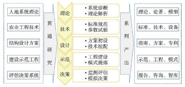
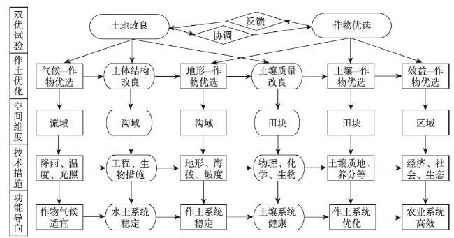
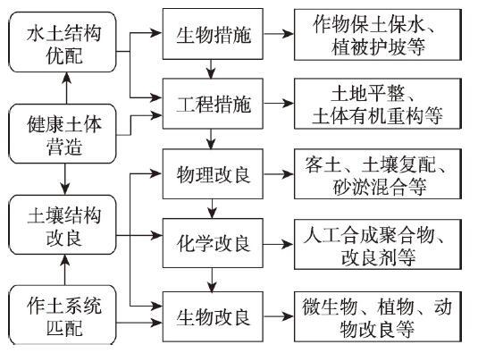
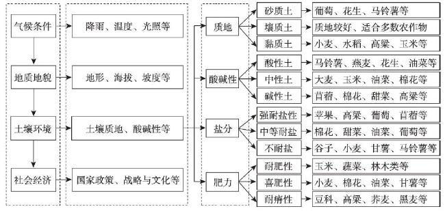
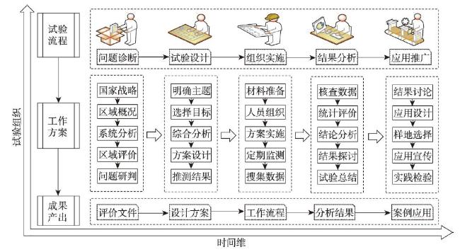
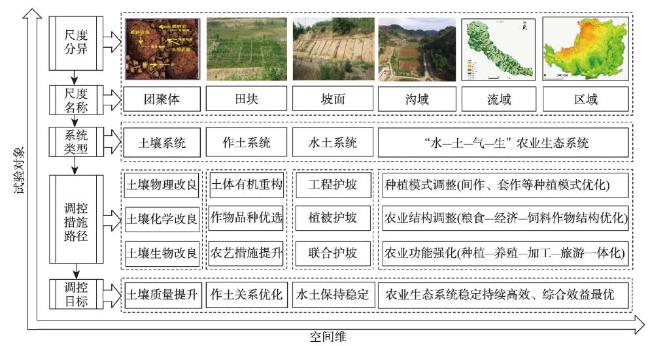
农业地理学是农业科学与地理科学的交叉学科,农业地理工程是地理学与工程学交叉研究在现代农业与乡村领域的进一步深化和系统应用。随着现代农业科学技术和人地系统科学的创新发展,区域农业基础建设的科技需求日益旺盛,农业地理工程试验成为农业工程技术研发和农田系统管理的重要任务。本文阐述了农业地理工程的科学内涵、试验原理与技术方法,并以黄土丘陵沟壑区为例开展了地理工程试验研究和农业高质量发展对策探讨。结果表明:① 农业地理工程试验主要包括针对特定区域地理环境和农业发展问题的水土配置、土层复配、大田试验、生态防护、地理空间分析与监测,旨在探明区域高标准农田建设、健康农业生态系统营造的水土气生资源要素耦合规律,建立可持续土地利用系统与多功能农业经营模式。② 农业生态系统试验主要包括沟道边坡防护方式、健康农田系统结构、作物与土壤匹配关系、耕地投入产出经济分析,通过开展土地改良、作物优选交互试验和田间试种,揭示新造地“作土关系”耦合机理与优化调控途径。③ 作土关系优化调控是工程试验设计的主要内容,包括气候—作物优选、土体结构改良、地形—作物优选、土壤质量改良、土壤—作物优选、效益—作物优选6个阶段。④ 农业地理工程技术应用的核心任务是深化贯通综合研究、揭示微观耦合机理、建立工程试验范式,其应用路径主要体现在时间维、空间维与逻辑维三个维度。新时期农业地理工程试验与示范应用,有利于丰富农业地理学前沿理论与方法论,对于推进地理工程化研究和服务农业农村高质量发展决策具有重要意义。

刘彦随 , 冯巍仑 , 李裕瑞 . 现代农业地理工程与农业高质量发展——以黄土丘陵沟壑区为例[J]. 地理学报, 2020 , 75(10) : 2029 -2046 . DOI: 10.11821/dlxb202010001
Agricultural geography is the interdisciplinary subject of agricultural science and geographical science, and agricultural geographical engineering is the further deepening and systematic application of the interdisciplinary research of geography and engineering in the field of modern agriculture and rural revitalization, and it is an important material basis to ensure the agricultural high-quality development. With the innovative development of modern agricultural science and technology and human-earth system science, the scientific and technological needs of regional agricultural infrastructure are increasingly strong, and agricultural geographical engineering experiments have become an important task of agricultural engineering technology research and farmland system management. This article expounds the scientific connotation, experimental principles and technical methods of agricultural geographical engineering, and takes the loess hilly and gully region as an example to carry out the experimental research on geographical engineering and discussed the countermeasures for high-quality agricultural development. Results show that: (1) Agricultural geographical engineering experiments mainly include soil and water allocation, soil layer composition, field experiment, ecological protection, geospatial analysis and monitoring for specific regional geographical environment and agricultural development issues, aiming to explore coupling law of resource elements for regional high-standard farmland construction and healthy agricultural ecosystem construction, and establish a sustainable land use system and multifunctional agricultural management model. (2) Agro-ecosystem experiments mainly includes trench slope protection methods, healthy farmland system structure, crop-soil matching relationship, economic analysis of farmland input and output, which aimed to reveals the coupling mechanism and optimal control approach of "crop-soil relationship" by carrying out interactive experiments and field trials for land improvement and crop optimization. (3) Optimization and regulation of crop-soil relationship is the main content of engineering experiment design, which includes six stages: climate-crop optimization, soil-body structure improvement, terrain-crop optimization, soil quality improvement, soil-crop optimization and benefit-crop optimization. (4) The core tasks of the application of agricultural geoengineering technology are to deepen the comprehensive research, reveal the micro-coupling mechanism and establish the engineering test paradigm, and its application path is mainly reflected in three dimensions of time, space, and logic. The geographical engineering experiment of modern agriculture and its application in the new era are conducive to enriching the frontier theories and methodology of agricultural geography, and are of great significance to the advancement of geographical engineering research and the decision-making of agricultural and rural high-quality development.
表1 农业地理工程试验机理与技术要点Tab. 1 The principle and technical points of agricultural geographical engineering experiment |
| 地域类型及特性 | 工程机理 | 技术要点 | 建设目标 |
|---|---|---|---|
| 沙地(沙化地)土地整治结构互补性 | 沙地缺什么:粘性 | 组分实验 | 沙土匹配 |
| 沙地需什么:粘土 | 结构试验 | 粘土特性 | |
| 方案是什么:土层 | 效能检验 | 复配构型 | |
| 沟道(水毁地)土地整治系统稳定性 | 沟道怕什么:洪灾 | 模拟实验 | 三流形态 |
| 沟道要什么:安全 | 平衡试验 | 三优方案 | |
| 方案是什么:土体 | 效能检验 | 水土配置 | |
| 村庄(空废地)土地整治空间组织性 | 村庄有什么:空宅 | 行为实验 | 农户选择 |
| 村庄要什么:安居 | 结构试验 | 土地挂钩 | |
| 方案是什么:社区 | 效能检验 | 三产融合 | |
| 山区(荒山地)土地整治人地协调性 | 农户缺什么:收入 | 家庭实验 | 增收潜力 |
| 农户要什么:资产 | 政策试验 | 土地资产 | |
| 方案是什么:三变 | 效能检验 | 股份合作 |
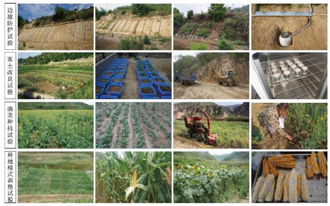
表2 农业地理工程试验方案设计的逻辑分析Tab. 2 Logical analysis of the scheme design of agricultural geographical engineering experiment |
| 逻辑维 | 边坡防护试验 | 客土改良试验 | 油菜种植试验 | 种植模式调整试验 |
|---|---|---|---|---|
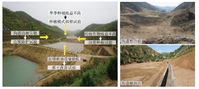
| 明确问题 | 工程边坡安全性与稳定性不高 | 新增耕地质量不高、土体沉降与湿陷 | 传统作物种植单一、经济效益低 | 单季种植模式的效益不高、资源浪费 |
| 选择目标 | 植被护坡技术与坡度适宜控制技术 | 客土改良技术,土壤快速熟化 | 作物优选技术,提升土地利用效率 | 一季改两季的作物优配与种植技术 |
| 系统综合 | 植被—土壤系统 | 水土耦合系统 | 作土匹配系统 | 农田利用系统 |
| 系统分析 | 控制坡度、植被护坡,保持水土资源 | 土体营造、土壤改良,提升土壤质量 | 引进高收益、多功能的作物品种 | 探索两季作物种植的沟道农业新模式 |
| 做出决策 | 不同坡度及植被措施的坡面综合效益 | 不同覆土类型和厚度的土壤改良效果 | 不同播期和播种密度的油菜种植 | 不同种植模式的作物产量与经济效益 |
| 付诸实施 | 延安羊圈沟流域,人工建设不同坡度边坡模拟工程削坡 | 延安羊圈沟流域,选取红粘土和马兰黄土取土场,机械施工 | 延安顾屯流域,购买华油杂62饲料油菜,种植测产 | 延安顾屯流域,购买试验作物良种,早春物候观测,种植测产 |
| [1] |
[ 蔡建明, 杨振山 . 国际都市农业发展的经验及其借鉴. 地理研究, 2008,27(2):362-374.]
|
| [2] |
[ 刘彦随 . 中国新时代城乡融合与乡村振兴. 地理学报, 2018,73(4):637-650.]
|
| [3] |
|
| [4] |
[ 刘彦随, 张紫雯, 王介勇 . 中国农业地域分异与现代农业区划方案. 地理学报, 2018,73(2):203-218.]
|
| [5] |
[ 胡焕庸 . 中国之农业区域. 地理学报, 1936,3(1):1-17.]
|
| [6] |
[ 周立三 . 试论农业区域的形成演变、内部结构及其区划体系. 地理学报, 1964,30(1):14-22.]
|
| [7] |
[ 黄秉维 . 生态平衡与农业地理研究: 生态平衡概念. 地理研究, 1982,1(1):3-8.]
|
| [8] |
[ 刘彦随 . 现代农业地理与土地利用创新研究: 贺吴传钧先生90华诞. 地理学报, 2008,63(4):353-358.]
|
| [9] |
[ 邓静中 . 全国综合农业区划的若干问题. 地理研究, 1982,1(1):9-18.]
|
| [10] |
[ 龙花楼, 刘彦随, 张小林 , 等. 农业地理与乡村发展研究新近进展. 地理学报, 2014,69(8):1145-1158.]
|
| [11] |
[ 吴传钧 . 因地制宜发挥优势逐步发展我国农业生产的地域专业化. 地理学报, 1981,48(4):349-357.]
|
| [12] |
[ 李裕瑞, 刘彦随, 龙花楼 , 等. 大城市郊区村域转型发展的资源环境效应与优化调控研究: 以北京市顺义区北村为例. 地理学报, 2013,68(6):825-838.]
|
| [13] |
[ 刘彦随 . 中国新农村建设地理论. 北京: 科学出版社, 2011.]
|
| [14] |
[ 王永生, 李玉恒, 刘彦随 . 现代农业双优工程试验原理与方法: 以毛乌素沙地为例. 中国工程科学, 2019,21(2):48-54.]
|
| [15] |
|
| [16] |
[ 姜凯斯, 刘正佳, 李裕瑞 , 等. 黄土丘陵沟壑区典型村域土地利用变化及对区域乡村转型发展的启示. 地理科学进展, 2019,38(9):1305-1315.]
|
| [17] |
|
| [18] |
|
| [19] |
[ 陈群利, 姚建陆, 孟天友 . 喀斯特山区坡耕地整治工程效益分析. 中国水土保持, 2007(7):27-28.]
|
| [20] |
[ 崔鹏, 王道杰, 韦方强 . 干热河谷生态修复模式及其效应: 以中国科学院东川泥石流观测研究站为例. 中国水土保持科学, 2005,3(3):60-64.]
|
| [21] |
|
| [22] |
[ 钱学森 . 要区别“地球科学”和地球表层学: 在地球表层学学术讨论会上的发言. 灾害学, 1987,2(3):1-5.]
|
| [23] |
[ 肖平 . 试论地理工程: 以红壤山区小流域开发治理的新模式设计为例. 地理研究, 1995,14(4):97-103.]
|
| [24] |
[ 唐登银 . 实验地理学与地理工程学. 地理研究, 1997,16(1):1-10.]
|
| [25] |
[ 刘彦随 . 土地综合研究与土地资源工程. 资源科学, 2015,37(1):1-8.]
|
| [26] |
|
| [27] |
[ 朱显谟 . 黄土高原国土整治“28字方略”的理论与实践. 中国科学院院刊, 1998,13(3):232-236.]
|
| [28] |
[ 山仑 . 我国著名水土保持专家工程院山仑院士论黄土高原治理与黄河断流问题. 水土保持通报, 1999,19(2):3-5.]
|
| [29] |
[ 傅伯杰 . 陕北黄土地区土地合理利用的途径与措施. 水土保持学报, 1989,3(3):33-39.]
|
| [30] |
[ 邵明安, 贾小旭, 王云强 , 等. 黄土高原土壤干层研究进展与展望. 地球科学进展, 2016,31(1):14-22.]
|
| [31] |
[ 刘彦随, 靳晓燕, 胡业翠 . 黄土丘陵沟壑区农村特色生态经济模式探讨. 自然资源学报, 2006,21(5):7438-7450.]
|
| [32] |
[ 刘彦随, 李裕瑞 . 黄土丘陵沟壑区沟道土地整治工程原理与设计技术. 农业工程学报, 2017,33(10):1-9.]
|
| [33] |
[ 谢冰祥 . 延安市治沟造地工程植被恢复及坡面水土保持工程设计. 水利科技与经济, 2014,20(5):38-39.]
|
| [34] |
[ 王铮, 吴必虎 . PRED问题与地理工程. 中国人口·资源与环境, 1992,2(2):45-47.]
|
| [35] |
[ 刘彦随 . 新时代乡村振兴地理学研究. 地理研究, 2019,38(3):461-466.
|
| [36] |
[ 蔡艳蓉, 李永红, 高照良 . 黄土高原地区土地资源分区研究. 农业灾害研究, 2015,5(5):38-47.]
|
| [37] |
[ 刘彦随, 冯德显 . 陕北绥德县可持续农业与农村经济发展评价. 陕西师范大学学报, 2001,29(1):85-89.]
|
| [38] |
[ 刘旭晔 . 土地可持续利用研究进展及未来研究趋势. 经济研究导刊, 2015, ( 9):172-176.]
|
| [39] |
[ 傅伯杰 . 黄土高原景观格局变化与土壤侵蚀. 北京: 科学出版社, 2014.]
|
| [40] |
|
| [41] |
[ 张志强, 程国栋 . 论西北地区生态环境建设问题与战略. 干旱区地理, 2001,6(3):243-250.]
|
| [42] |
[ 黄志霖, 陈利顶, 傅伯杰 . 黄土丘陵沟壑区不同土地利用类型水保效应动态变化研究. 土地变化科学与生态建设学术研讨会论文集, 2002: 249-257.]
|
| [43] |
[ 钟莉娜, 赵文武, 吕一河 , 等. 黄土丘陵沟壑区景观格局演变特征: 以陕西省延安市为例. 生态学报, 2014,34(12):3368-3377.]
|
| [44] |
|
| [45] |
|
| [46] |
|
| [47] |
|
| [48] |
|
| [49] |
|
| [50] |
|
| [51] |
|
| [52] |
[ 刘彦随, 陈宗峰, 李裕瑞 . 黄土丘陵沟壑区饲料油菜种植试验及其产业化前景: 以延安治沟造地典型项目区为例. 自然资源学报, 2017,32(12):2065-2074.]
|
| [53] |
[ 张子龙, 鹿晨昱, 陈兴鹏 , 等. 陇东黄土高原农业生态效率的时空演变分析: 以庆阳市为例. 地理科学, 2014,34(4):472-478.]
|
| [54] |
|
| [55] |
[ 贺春雄 . 延安治沟造地工程的现状、特点及作用. 地球环境学报, 2015,6(4):255-260.]
|
| [56] |
[ 刘振明 . 治沟造地过程中存在的问题与保障措施. 科技创新与应用, 2019(24):150-151.]
|
| [57] |
[ 王鹏, 段星星, 赵禹 , 等. 治沟造地新增耕地的土壤质量评价: 延安宝塔区为例. 土地开发工程研究, 2019,4(1):41-45.]
|
| [58] |
|
| [59] |
|
| [60] |
[ 刘彦随 . 现代人地关系与人地系统科学. 地理科学, 2020,40(8):1221-1234.]
|
/
| 〈 |
|
〉 |