
基于多主体模型的典型区域退耕还林工程实施空间模拟
|
杨微石(1985-), 男, 江西赣州人, 博士, 研究方向为土地利用模拟。E-mail: 43106363@qq.com |
收稿日期: 2019-01-21
要求修回日期: 2020-04-24
网络出版日期: 2020-11-25
基金资助
国家自然科学基金项目(41571098)
国家自然科学基金项目(41530749)
中国科学院战略性先导科技专项(XDA19040304)
国家重点研发计划(2017YFC1502903)
国家重点研发计划(2018YFC1508805)
中国科学院重点部署项目(ZDRW-ZS-2016-6-4)
版权
Spatial simulation of "Grain to Green Program" implementation in a typical region based on agent-based model
Received date: 2019-01-21
Request revised date: 2020-04-24
Online published: 2020-11-25
Supported by
National Natural Science Foundation of China(41571098)
National Natural Science Foundation of China(41530749)
Strategic Priority Research Program of Chinese Academy of Sciences(XDA19040304)
National Key R&D Program of China(2017YFC1502903)
National Key R&D Program of China(2018YFC1508805)
Key Program of Chinese Academy of Sciences(ZDRW-ZS-2016-6-4)
Copyright
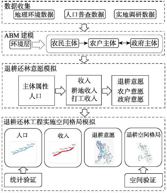
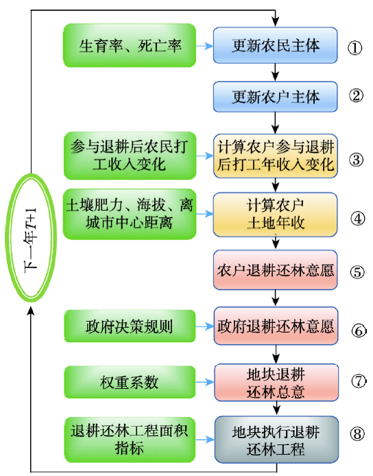
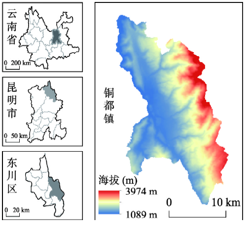
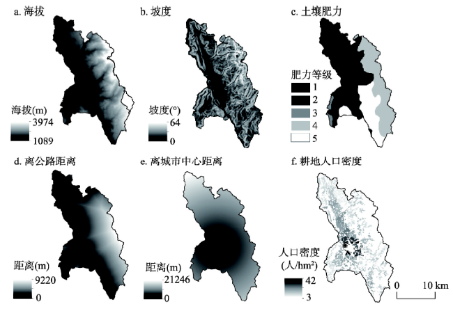
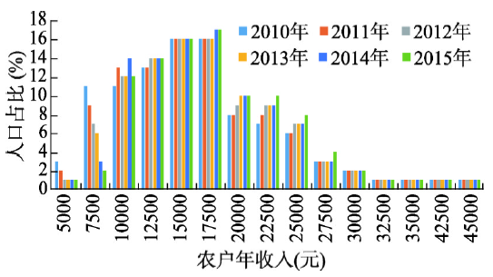
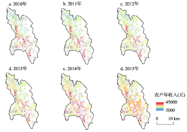
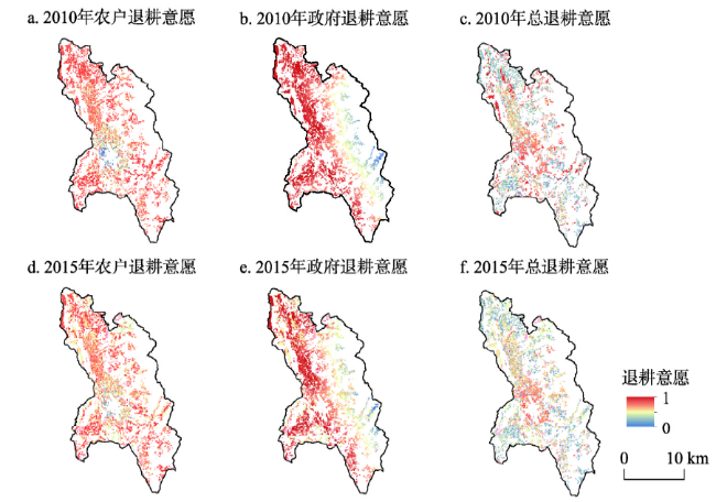
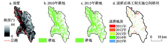
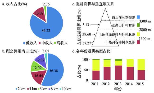
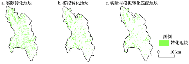
土地利用变化是全球变化的重要驱动力,模拟是研究土地变化重要的方法。退耕还林是中国山区土地利用变化的重要原因。当前退耕还林模拟在综合社会与空间途径方面的不足限制了退耕还林模拟的空间精度及后续社会效益研究。结合社会和空间途径精确模拟退耕还林的空间过程可为该工程实施提供科学依据。本文以云南省东川区铜都镇为研究区,基于人口普查数据、地理环境数据、实地调研数据,综合考虑农民、农户和政府3类主体,基于多主体模型构建了退耕还林工程实施的空间模型,模拟了2010—2015年铜都镇具有空间特征的农户年收入、农户/政府退耕意愿和退耕还林工程空间实施过程。研究发现退耕还林工程实施主要与坡度、交通和农户收入有关,与土壤肥力相关性较小,坡度25°~30°的耕地占了81.47%,离道路0~2 km交通条件较好的地段占56.37%,农户年收入较低的区域退耕还林比例较高,且退耕还林工程的实施显著提高了铜都镇收入,2010—2015年户均收入提高了1475元。本文模拟结果空间精度为91.12%。本文构建的退耕还林工程实施空间模拟方法可为其它区域提供方法借鉴,以期为中国生态保护和精准扶贫等工程实施提供科学支撑。

杨微石 , 戴尔阜 , 郑度 , 董玉祥 , 尹乐 , 马良 , 王隽雄 , 潘理虎 , 秦世鹏 . 基于多主体模型的典型区域退耕还林工程实施空间模拟[J]. 地理学报, 2020 , 75(9) : 1983 -1995 . DOI: 10.11821/dlxb202009012
Landuse change is an essential driving force of global climate change. Dynamic simulations are helpful for understanding and explaining the changing rules and characteristics of the land system. The "Grain to Green Program" (GTGP) is a critical contributing factor to landuse change in China's mountainous areas. Presently, the deficiency of integrated social and spatial approaches in the simulation of the "GTGP" limits the spatial accuracy of the social benefits simulation and its subsequent research. The accurate simulation of the "GTGP", by combining social and spatial approaches, can provide scientific evidence for the completion of this project. Taking Tongdu Town, Dongchuan district in Yunnan province as the research area, this study identified three kinds of agents: farmers, farmer households, and the government based on census, geographical information and field survey data. In addition, this research constructed a regional spatial simulation of the "GTGP" implementation based on agent-based model. It conducted spatial simulations of Tongdu Town from 2011 to 2015, including the annual income of farmer households, the willingness of farmer households and the government towards the program, and the spatial processes implementation of the "GTGP". The results showed that the implementation of the "GTGP" was mainly related to the slope, the traffic, and the income of farmer households. Specifically, 81.47% of the "GTGP" program conducted in this areas was on slopes of 25°-30°, and 56.37% of them was 0-2 km away from the road with convenient traffic conditions, and the proportion of the "GTGP" areas with low annual income of farmers was relatively high. The correlation between "GTGP" areas and soil fertility was low. The implementation of the project significantly enhanced the revenue of the study area, with an average household income increase of 1475 yuan from 2010 to 2015. The spatial accuracy of the simulation results was 91.12%. The spatial simulation methods constructed in this study can provide references for the implementation of the "GTGP" in other regions, which can contribute to applications of ecological protection and targeted poverty alleviation programs in China.
Key words: Grain to Green Program; agent-based model; land use; Tongdu Town; mountainous areas
表1 区域退耕还林工程实施空间模拟数据列表Tab. 1 Spatial simulated data list for the regional spatial simulation of "Grain to Green Program" |
| 数据类别 | 数据项 | 数据来源 |
|---|---|---|
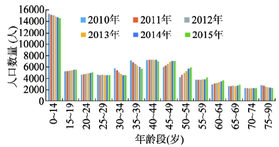
| 主体属性数据 | 农户家庭规模比例 | 人口普查数据、实地调研 |
| 年龄结构 | ||
| 生育率(分年龄段) | ||
| 死率亡(分年龄段) | ||
| 农业人口总量 | ||
| 打工收入(分年龄段) | ||
| 耕地收入数据 | 同海拔最高肥力耕地最大年收入() | 实地调研 |
| 耕地坡度系数(αSD) | ||
| 耕地肥力等级系数(αSQ) | ||
| 耕地年交通费用(CostTra) | ||
| 单位耕地最低需求劳动力(LaborMin) | ||
| 地理环境数据 | 海拔 | 中国科学院资源环境科学数据中心、遥感影像处理、部门调研等 |
| 坡度等级 | ||
| 土壤肥力等级 | ||
| 土地利用类型 | ||
| 离公路网距离 | ||
| 离城市中心距离 | ||
| 行政区划 | ||
| 退耕数据 | 退耕还林工程面积指标 | 部门调研 |
| [1] |
|
| [2] |
|
| [3] |
|
| [4] |
[ 戴尔阜, 马良. 土地变化模型方法综述. 地理科学进展, 2018,37(1):152-162.]
|
| [5] |
[ 李少英, 刘小平, 黎夏, 等. 土地利用变化模拟模型及应用研究进展. 遥感学报, 2017,21(3):329-340.]
|
| [6] |
|
| [7] |
[ 薛领, 杨开忠. 复杂性科学理论与区域空间演化模拟研究. 地理研究, 2002,21(1):79-88.]
|
| [8] |
[ 翟瑞雪, 戴尔阜. 基于主体模型的人地系统复杂性研究. 地理研究, 2017,36(10):1925-1935.]
|
| [9] |
|
| [10] |
|
| [11] |
|
| [12] |
|
| [13] |
[ 刘博杰, 张路, 逯非, 等. 中国退耕还林工程温室气体排放与净固碳量. 应用生态学报, 2016,27(6):1693-1707.]
|
| [14] |
State Forestry Administration. Grain to Green Project Ecological Benefits Monitoring National Reports (2014). Beijing: China Forestry Publishing House, 2015: 15-43.
[ 国家林业局. 退耕还林工程生态效益监测国家报告(2014). 北京: 中国林业出版社, 2015: 15-43.]
|
| [15] |
|
| [16] |
|
| [17] |
|
| [18] |
|
| [19] |
[ 余强毅, 吴文斌, 唐华俊, 等. 复杂系统理论与Agent模型在土地变化科学中的研究进展. 地理学报, 2011,66(11):1518-1530.]
|
| [20] |
|
| [21] |
|
| [22] |
|
| [23] |
|
| [24] |
[ 樊杰. 中国主体功能区划方案. 地理学报, 2015,70(2):186-201.]
|
| [25] |
[ 贾松伟, 韦方强, 崔鹏. 小江流域土地利用变化及其趋势分析. 水土保持学报, 2006,20(5):154-157.]
|
| [26] |
[ 兰恒星, 伍法权, 周成虎, 等. 基于GIS的云南小江流域滑坡因子敏感性分析. 岩石力学与工程学报, 2002,21(10):1500-1506.]
|
| [27] |
[ 陈循谦. 云南小江流域泥石流成因初步分析. 中国水土保持, 1987(4):12-65.]
|
| [28] |
[ 陈循谦. 云南小江流域的泥石流灾害. 灾害学, 1990,5(2):53-57.]
|
| [29] |
|
/
| 〈 |
|
〉 |