
1570—1971年长江镇扬河段江心沙洲的演变过程及原因分析
|
杨霄(1988-), 男, 山东青岛人, 博士后, 中国地理学会会员(S110009064M), 主要从事历史自然地理研究。E-mail: yangx0607@126.com |
收稿日期: 2019-06-05
要求修回日期: 2020-04-14
网络出版日期: 2020-09-25
基金资助
国家社会科学基金重大项目(19ZDA192)
中国博士后科学基金项目(2019M661577)
版权
Evolution processes of the sandbanks in the Zhenjiang-Yangzhou reach of the Yangtze River and their driving forces (from 1570 to 1971)
Received date: 2019-06-05
Request revised date: 2020-04-14
Online published: 2020-09-25
Supported by
Major Project of National Social Science Foundation of China(19ZDA192)
China Postdoctoral Science Foundation(2019M661577)
Copyright
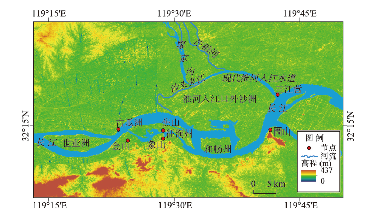
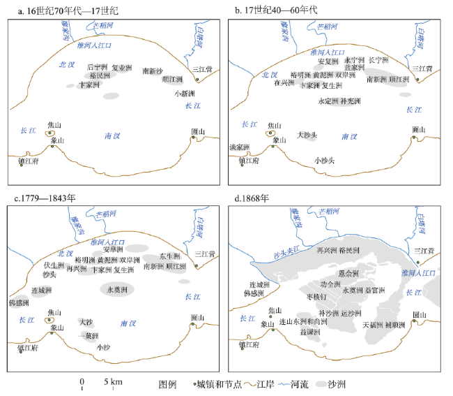
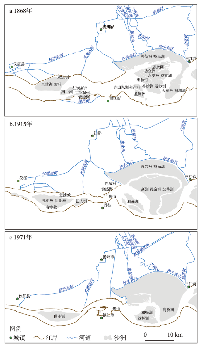
受黄河夺淮的影响,从1570年开始淮河下游由向东独流入海逐渐演变为南下入江,成为长江一条支流。这一变化为长江河流地貌的演变增加了新的变量,改变了长江镇扬河段原有的河槽特征和水流结构,洲滩冲淤、岸线进退随之发生变化。本文使用历史文献考证与古地图判读相结合的研究方法,对淮河入江口外沙洲群的形成年代与演变过程进行考证,认为裕民洲、南新洲等沙洲至少在17世纪前已经存在于淮河入江口外,是成化、弘治年间藤料沙等沦没后新淤长的沙洲。淮河入江后上述沙洲不断扩大、与新淤长沙洲一起向北并岸,致使镇扬河段北汊消亡,并由江心洲型河床向弯曲型河床转化。曲流的形成又使位于上游凹岸的瓜洲受到侵蚀,而位于凸岸的镇江不断淤积,长江镇扬河段逐渐演变为今天的面貌。
杨霄 . 1570—1971年长江镇扬河段江心沙洲的演变过程及原因分析[J]. 地理学报, 2020 , 75(7) : 1512 -1522 . DOI: 10.11821/dlxb202007013
Under the influence of the changing relationship between the Yellow River and the Huaihe River, the lower reaches of the Huaihe River had gradually drained into the Yangtze River since 1570 AD, and finally became a tributary of the Yangtze River. This transformation added new variations to the evolution of the Yangtze River's fluvial processes by changing the original riverbed features and currents of the Zhenjiang-Yangzhou reach. This article analyzed three surveyed maps, discussed related historical literature and investigated some antique maps to explore the formation and the evolution of the sandbanks outside the estuary of the Huaihe River. Some sandbanks including the Yumin Sandbar and Nanxin Sandbar appeared before the 17th century due to the disintegration of original sandbars such as Tengliao Sandbar,which disappeared during the Chenghua and Hongzhi reigns in the Ming Dynasty (1465-1505 AD). Since the Huaihe River entered into the Yangtze River, the Yumin Sandbar and Nanxin Sandbar had continued to expand and banked to the north along with the newly-formed sandbanks. At last, the northern channel of the Zhenjiang-Yangzhou reach demised and the riverbed transformed from a straightforward bifurcation into a curved one. Accordingly, the formation of meandering flow began to erode Guazhou Town on the upstream concave bank and silt Zhenjiang Town on the convex bank, gradually reshaping the Zhenjiang-Yangzhou reach of the Yangtze River into its current configuration.
| [1] |
[ 徐近之. 淮北平原与淮河中游的地文. 地理学报, 1953,19(2):203-233.]
|
| [2] |
[ 邹德森. 黄、淮水对长江下游镇澄河段影响的探讨//中国水利学会水利史研究会. 水利史研究会成立大会论文集. 北京: 水利电力出版社, 1984: 155-161.]
|
| [3] |
Institute of Geography of Chinese Academy of Sciences, Institute of Water Resources and Hydropower Research of the Yangtze River, Yangtze River Waterway Bureau Planning and Design Institute. River Characteristics and Evolution of the Middle and Lower Reaches of the Yangtze River. Beijing: Science Press, 1985: 73-143.
[ 中国科学院地理研究所, 长江水利水电科学研究院, 长江航道局规划设计研究所. 长江中下游河道特性及其演变. 北京: 科学出版社, 1985: 73-143.]
|
| [4] |
[ 王庆, 陈吉余. 淮河入长江河口的形成及其动力地貌演变//历史地理第16辑. 上海: 上海人民出版社, 2000: 40-49.]
|
| [5] |
[ 黄锡荃, 曹沛奎. 长江镇扬河段河槽演变过程. 华东师范大学学报(自然科学版), 1964(2):143-154.]
|
| [6] |
[ 李从先, 李萍, 成鑫荣. 海洋因素对镇江以下长江河段沉积的影响. 地理学报, 1983,38(2):128-140.]
|
| [7] |
[ 陈吉余, 沈焕庭, 恽才兴, 等. 长江河口动力过程和地貌演变. 上海: 上海科学技术出版社, 1988.]
|
| [8] |
[ 杨怀仁, 徐馨, 杨达源, 等. 长江中下游环境变迁与地生态系统. 南京: 河海大学出版社, 1995.]
|
| [9] |
[ 印志华. 从出土文物看长江镇扬河段的历史变迁. 东南文化, 1997(4):18-24.]
|
| [10] |
[ 李义天, 唐金武, 朱玲玲, 等. 长江中下游河道演变与航道整治. 北京: 科学出版社, 2012.]
|
| [11] |
[ 夏云峰, 闻云呈, 徐华, 等. 长江河口段水沙运动及河床演变. 北京: 人民交通出版社, 2015.]
|
| [12] |
[ 杨霄, 韩昭庆. 1717—2011年高宝诸湖的演变过程及其原因分析. 地理学报, 2018,73(1):129-137.]
|
| [13] |
[ 陈吉余, 恽才兴. 南京吴淞间长江河槽的演变过程. 地理学报, 1959,25(3):221-239.]
|
| [14] |
[ 孙仲明, 濮静娟. 长江城陵矶—江阴河道历史变迁的特点//中国科学院地理研究所. 地理集刊第13号地貌. 北京: 科学出版社, 1981: 1-17.]
|
| [15] |
[ 陈吉余. 长江河口治理: 过去、现在和未来//陈吉余(伊石)2000—从事河口海岸研究55年论文选. 上海: 华东师范大学出版社, 2000: 421-431.]
|
| [16] |
[ 卢雪燕. 故宫典藏古地图选粹(上册). 台北: 故宫博物院, 2018: 25.]
|
| [17] |
[ 谢国兴, 林天人. 方舆搜览:大英图书馆所藏中文历史地图. 台北: 中研院台湾史研究所, 2015: 168-169.]
|
| [18] |
[ 韩昭庆. 洪泽湖演变的历史过程及其背景分析. 中国历史地理论丛, 1998(2):61-76.]
|
| [19] |
The Huaihe River Commission of the Ministry of Water Resources. A Brief History of Huaihe River Water Conservancy. Beijing: Water Conservancy and Electric Power Press, 1990: 253.
[ 水利部治淮委员会. 淮河水利简史. 北京: 水利电力出版社, 1990: 253.]
|
| [20] |
The Experimental Group of the Yangtze River, Division of Geomorphology, Institute of Geography of Chinese Academy of Sciences. An experimental study on the fluvial processes of the braided stream in the middle and lower reaches of the Yangtze River. Acta Geographica Sinica, 1978,32(2):128-141.
[ 中国科学院地理研究所地貌室长江实验小组. 长江中下游分汊河道演变的实验研究. 地理学报, 1978,32(2):128-141.]
|
| [21] |
[ 余文畴. 长江下游分汊河道节点在河床演变中的作用. 泥沙研究, 1987,12(4):14-23.]
|
| [22] |
[ 黄锡荃, 柳中坚. 长江下游分汊河型内部结构和空间效应的研究. 地理学报, 1991,46(2):169-177.]
|
| [23] |
|
| [24] |
[ 倪晋仁, 马蔼乃. 河流动力地貌学. 北京: 北京大学出版社, 1998: 70-302.]
|
/
| 〈 |
|
〉 |