
长三角地区城市化空间关联特征及内在机制
|
崔耀平(1984-), 男, 河南周口人, 教授, 博导, 研究方向为国土资源利用。E-mail: cuiyp@lreis.ac.cn |
收稿日期: 2018-12-30
要求修回日期: 2020-02-20
网络出版日期: 2020-08-25
基金资助
国家自然科学基金项目(41671425)
国家自然科学基金项目(41401504)
河南大学人才特区科研项目
版权
Urban spatial correlation characteristics and intrinsic mechanism in the Yangtze River Delta region
Received date: 2018-12-30
Request revised date: 2020-02-20
Online published: 2020-08-25
Supported by
National Natural Science Foundation of China(41671425)
National Natural Science Foundation of China(41401504)
Scientific Research Start-up Funding of Special Talent Zone in Henan University (Feng)
Copyright
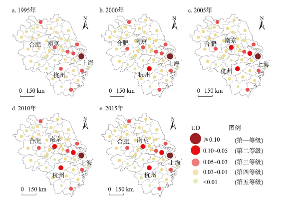
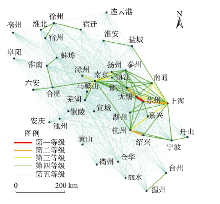
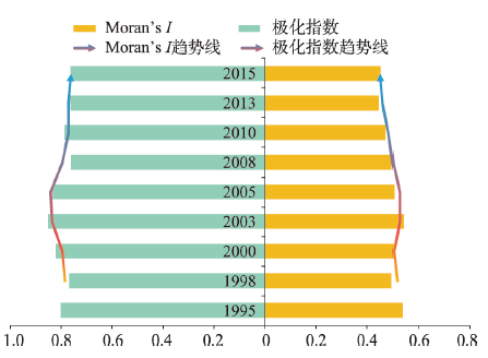
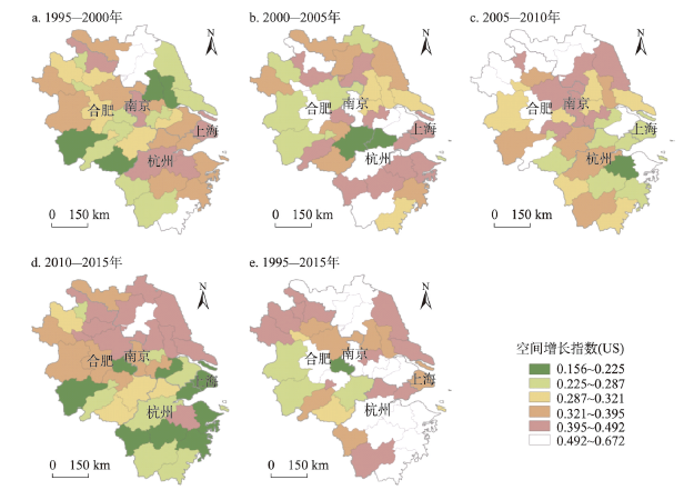
中国正处于城市化快速发展阶段,但当前研究在综合反映城市化的时空特征时,往往忽略区域城市间的空间关联及其演化过程,无法有效地揭示区域城市间的相互影响和内在机制。基于空间极化及扩散理论和系统分析方法,剖析了长三角地区城市化的空间演化过程。结果显示:① 1995—2015年间长三角地区城市化的规模等级特征明显,作为区域增长极,上海处于第一等级,南京、杭州、苏州为第二等级;城市化空间关联指数也表明,以上海、苏州、杭州等10个城市构成区域最为密集的空间联系网络。② 研究时段内,城市化过程中空间极化和空间扩散同时存在,且空间极化的城市往往会进入新的扩散阶段,以南京、杭州等城市表现最为明显。该结果证实了各城市间在不同发展阶段具有不同的空间作用关系。本文还探讨了区域城市化的驱动机制,表明区域内产业升级和转移是形成空间极化或扩散作用的主要内生动力。本研究可为区域发展规划提供重要的科学支撑。
崔耀平 , 刘玄 , 李东阳 , 邓晴心 , 徐佳宁 , 石欣瑜 , 秦耀辰 . 长三角地区城市化空间关联特征及内在机制[J]. 地理学报, 2020 , 75(6) : 1301 -1315 . DOI: 10.11821/dlxb202006015
China is experiencing rapid urbanization. It is of great significance to clarify the characteristics of urban spatial expansion and its evolution law for regional coordinated development. Urbanization involves many aspects such as economy and population. However, current researches still face challenges in comprehensively reflecting the spatial pattern, evolution process, and intrinsic mechanism of regional urbanization, and they cannot effectively reveal and quantify the spatial correlation and evolution process of regional urbanization. Based on the data of economy, population and urban space in the Yangtze River Delta region from 1995 to 2015, this paper used spatial polarization and diffusion theory to quantitatively analyze the spatial evolution process and characteristics of urbanization. The results showed that: (1) The characteristics of urbanization level in the study area were obvious. Shanghai was at the first level, Nanjing, Hangzhou and Suzhou were at the second level, and the rest of the cities were at the third, fourth and fifth levels. The spatial correlation intensity of urbanization shows that the high-value level was concentrated in the eastern part of the region and 10 cities, such as Shanghai, Suzhou and Hangzhou, constituted the most intensive urbanization development spatial network. (2) During the study period, the spatial polarization and spatial diffusion characteristics existed simultaneously in the Yangtze River Delta region. During the study period, a diffused region always rapidly presented a patttern of polarization in space, then the polarization weakened and turned into a new diffusion phase. It is most obvious in Nanjing and Hangzhou among all the 41 cities. Our findings completely demonstrate that the spatial correlation among cities is changing over time. This study also explored the driving mechanism of regional urbanization, indicating that industrial upgrading and transfer within the study area is the main endogenous driving force for spatial polarization or diffusion. Our study has important theoretical and practical value for future regional development planning.
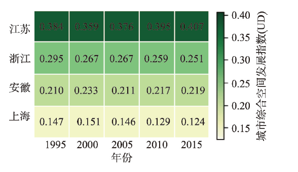
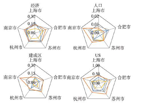
表1 长三角地区主要城市的综合空间发展指数(UD)值Tab. 1 Urbanization comprehensive development (UD) values of major cities in the Yangtze River Delta region |
| 主要城市* | 1995年UD值 | 2000年UD值 | 2005年UD值 | 2010年UD值 | 2015年UD值 |
|---|---|---|---|---|---|
| 上海市 | 0.147 | 0.151 | 0.146 | 0.129 | 0.124 |
| 南京市 | 0.049 | 0.049 | 0.061 | 0.059 | 0.059 |
| 苏州市 | 0.047 | 0.043 | 0.053 | 0.058 | 0.058 |
| 杭州市 | 0.045 | 0.054 | 0.057 | 0.056 | 0.054 |
| 合肥市 | 0.029 | 0.033 | 0.036 | 0.041 | 0.042 |
| 宁波市 | 0.037 | 0.036 | 0.037 | 0.043 | 0.040 |
| 徐州市 | 0.040 | 0.036 | 0.034 | 0.041 | 0.039 |
| 无锡市 | 0.040 | 0.038 | 0.042 | 0.040 | 0.039 |
| 南通市 | 0.038 | 0.033 | 0.031 | 0.032 | 0.035 |
| 温州市 | 0.038 | 0.041 | 0.037 | 0.034 | 0.034 |
注:*主要城市是指在研究时段内的UD持续排名前10位的城市。 |
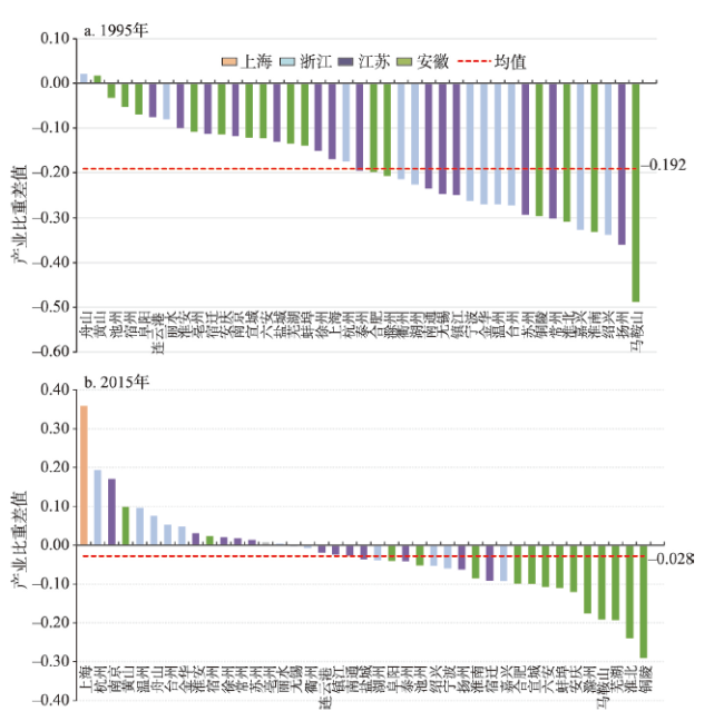
表2 1995年和2015年长三角城市二、三产业产值指标统计Tab. 2 Statistic indicators of secondary and tertiary industries in the Yangtze River Delta region in 1995 and 2015 |
| 指标量 | 年份 | 均值 | 标准差 | 变异系数 | Rc(%) |
|---|---|---|---|---|---|
| 第二产业 | 1995 | 165.93 | 237.97 | 143.42 | -31.58 |
| 第二产业 | 2015 | 1775.26 | 1741.10 | 98.13 | |
| 第三产业 | 1995 | 99.47 | 161.30 | 162.16 | -10.34 |
| 第三产业 | 2015 | 2001.46 | 2910.20 | 145.40 |
注:Rc表示变异系数在1995—2015年的变动幅度。 |
| [1] |
[ 方创琳, 王岩. 中国新型城镇化转型发展战略与转型发展模式. 中国城市研究, 2015,6:3-17.]
|
| [2] |
[ 关伟, 曹佳宾, 许淑婷. 东北三省服务业发展空间极化的演变及驱动因子分析. 地理科学, 2015,35(6):733-741.]
|
| [3] |
|
| [4] |
|
| [5] |
|
| [6] |
|
| [7] |
|
| [8] |
|
| [9] |
|
| [10] |
|
| [11] |
[ 刘帅宾, 杨山, 王钊. 基于人口流的中国省域城镇化空间关联特征及形成机制. 地理学报, 2019,74(4):648-663.]
|
| [12] |
|
| [13] |
[ 叶磊, 欧向军. 长三角地区经济极化过程与空间演变分析. 地理科学进展, 2012,31(12):1668-1677.]
|
| [14] |
[ 葛莹, Miron J, 蒲英霞, 等. 基于边际K函数的长三角地区城市群经济空间划分. 地理学报, 2015,70(4):528-538.]
|
| [15] |
[ 王钊, 杨山, 龚富华, 等. 基于城市流空间的城市群变形结构识别: 以长江三角洲城市群为例. 地理科学, 2017,37(9):1337-1344.]
|
| [16] |
[ 陈伟, 刘卫东, 柯文前, 等. 基于公路客流的中国城市网络结构与空间组织模式. 地理学报, 2017,72(2):224-241.]
|
| [17] |
[ 王丰龙, 曾刚, 叶琴, 等. 基于创新合作联系的城市网络格局分析: 以长江经济带为例. 长江流域资源与环境, 2017,26(6):797-805.]
|
| [18] |
[ 王姣娥, 焦敬娟, 金凤君. 高速铁路对中国城市空间相互作用强度的影响. 地理学报, 2014,69(12):1833-1846.]
|
| [19] |
[ 高金龙, 包菁薇, 刘彦随, 等. 中国县域土地城镇化的区域差异及其影响因素. 地理学报, 2018,73(12):2329-2344.]
|
| [20] |
[ 李玏, 顾朝林. 基于等级—网络分析框架的泛长江三角洲中心城市评价研究. 长江流域资源与环境, 2018,27(5):949-959.]
|
| [21] |
[ 李正华, 徐小平, 杜建国. 长三角区域经济发展不均衡和极化的演化分析. 经济问题探索, 2008(6):23-29.]
|
| [22] |
[ 徐建华. 计量地理学. 北京: 高等教育出版社, 2014.]
|
| [23] |
|
| [24] |
[
|
| [25] |
|
| [26] |
|
| [27] |
|
| [28] |
[ 陈建军. 长江三角洲地区产业结构与空间结构的演变. 浙江大学学报(人文社会科学版), 2007,37(2):88-98.]
|
| [29] |
|
| [30] |
[ 胡安俊, 孙久文. 中国制造业转移的机制、次序与空间模式. 经济学(季刊), 2014,13(4):1533-1556.]
|
| [31] |
[ 金凤君, 王成金, 李秀伟. 中国区域交通优势的甄别方法及应用分析. 地理学报, 2008,63(8):787-798.]
|
| [32] |
[ 范辉, 刘卫东, 吴泽斌, 等. 浙江省人口城市化与土地城市化的耦合协调关系评价. 经济地理, 2014,34(12):21-28.]
|
| [33] |
|
| [34] |
[ 方创琳. 中国城市群形成发育的政策影响过程与实施效果评价. 地理科学, 2012,32(3):257-264.]
|
| [35] |
[ 腾云, 陆大道, 甘国辉. 中国开放政策对区域发展的作用. 地理学报, 2001,56(5):580-588.
|
/
| 〈 |
|
〉 |