
喜马拉雅山脉中段土地覆被的垂直分异特征
|
张镱锂(1962-), 男, 研究员, 博士生导师, 主要从事生物地理与自然地理综合研究。E-mail: zhangyl@igsnrr.ac.cn; wuxuexxl@163.com |
收稿日期: 2018-10-10
要求修回日期: 2020-01-07
网络出版日期: 2020-07-25
基金资助
国家自然科学基金项目(41761144081)
中国科学院战略性先导科技专项(XDA20040201)
第二次青藏高原综合科学考察研究(2019QZKK0603)
版权
Vertical variation of land cover in the Central Himalayas
Received date: 2018-10-10
Request revised date: 2020-01-07
Online published: 2020-07-25
Supported by
National Nature Sciences Foundation of China(41761144081)
Strategic Priority Research Program of Chinese Academy of Sciences(XDA20040201)
The Second Tibetan Plateau Scientific Expedition and Research(2019QZKK0603)
Copyright
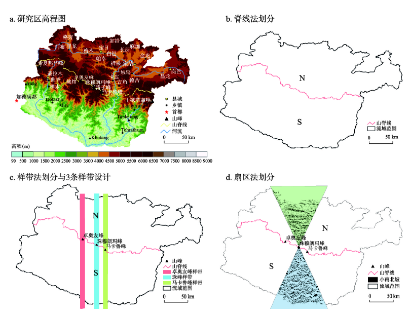
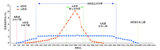
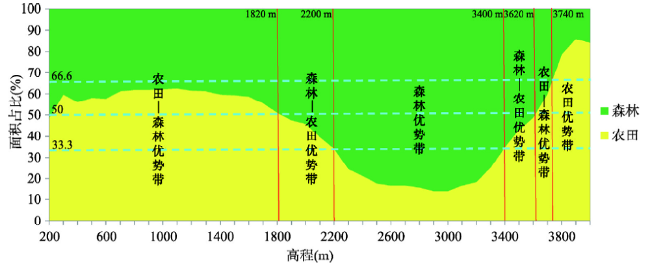
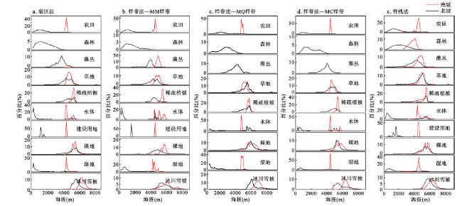
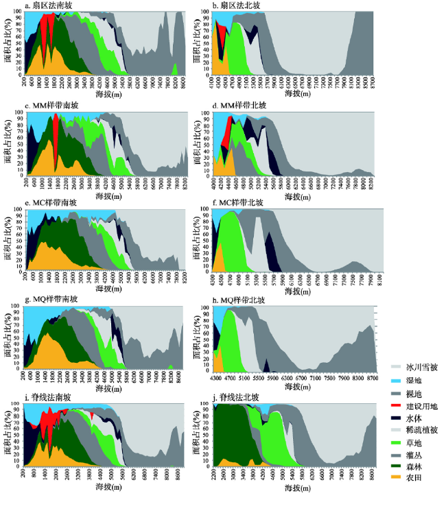
喜马拉雅山脉中段的珠穆朗玛峰等地,海拔高差巨大、生境复杂多变、土地覆被类型多样且植被垂直带谱完整,是全球范围内研究土地覆被垂直变化的理想场所。本文基于30 m空间分辨率的土地覆被数据(2010年)和DEM数据,在ArcGIS和Matlab平台的支持下,提出并运用脊线法、样带法和扇区法3种山地南北坡划分方法,研究了喜马拉雅山土地覆被垂直分布与结构差异。结果表明:① 山地土地覆被分布具有明确的垂直地带性结构特征,喜马拉雅中部土地覆被垂直带谱为南六北四式,土地覆被垂直带谱中具有人类活动的特点。② 南北坡之间的土地覆被垂直带谱差异明显,南坡土地覆被类型完整多样,北坡相对简单;对同类型土地覆被而言,南坡较北坡分布高程低、幅度宽。③ 依据各类型分布面积比随海拔变化情况,土地覆被类型在南北坡上的垂直分布可分为4种模式:冰川雪被、稀疏植被和草地为单峰分布型,裸地为南单峰北双峰分布型。④ 3种划分方法中,南坡的土地覆被垂直带结构具有相似性,而北坡的土地覆被垂直带结构存在差异,扇区法较好地反映了土地覆被自然分布格局。
张镱锂 , 吴雪 , 郑度 . 喜马拉雅山脉中段土地覆被的垂直分异特征[J]. 地理学报, 2020 , 75(5) : 931 -948 . DOI: 10.11821/dlxb202005004
The Qomolangma Mountain region within the Central Himalayas is characterized by obvious altitudinal variation, habitat complexity, and land cover diversity. This region is therefore one of the most sensitive areas to climate change in the world. Besides, because this region has the most complete natural vertical spectrum in the world, it is ideal for studying the vertical structure of alpine land cover. Utilizing land cover data for 2010 (30 m resolution) along with digital elevation model outputs, three division methods were defined that encompass the northern and southern slopes of Qomolangma Mountain. These comprised the ridgeline method, the sample transect method, and the sector method. The study investigated altitudinal distributions, similarities and differences, and changes in the degree of land cover on the northern and southern slopes of the Himalayas area using the software ArcGIS and MATLAB tools and division models. The main results of this analysis are listed as follows:
Firstly, the distribution of land cover in mountainous areas was characterized by an obvious vertical spectrum structure, with the south-six and north-four pattern of vertical spectrum of land cover in the Central Himalayas marked by the influence of human activities. Secondly, zonal distribution was exhibited by forests, grasslands, sparse vegetation, barren land, glaciers, and snow covers from low to high altitudes. It was markedly different in the composition and structure of land cover vertical spectrum between the northern and southern slopes of this mountain area. The vertical spectrum of land cover types on the southern slope was complete and diverse, but it was relatively simple on the northern slope. The study shows that given the same land cover type, the amplitude of elevation distribution on the southern slope was wide, while that on the northern slope was narrow. The distribution of land cover types on the southern slope was low. Thirdly, the results show that the area distribution ratio of each land cover type varied with elevation according to change mode. Vertical distribution patterns of land cover types on the southern and northern slopes were therefore divided into four categories, with glaciers, snow, sparse vegetation, and grasslands conforming to unimodal distribution patterns. The bare land also followed a unimodal distribution pattern on the southern slope, but it followed a bimodal one on the northern slope. Fourthly, all kinds of vertical belt structures and land cover divisions on the southern slope were similar, but they were different from one another on the northern slope due to division methods. In comparison with field survey data, results reported here for the sector method were more in line with the actual situation.
Key words: land cover; altitudinal zonation; Central Himalayas; Mt. Qomolangma; Mt. Makalu; Mt. Cho Oyu
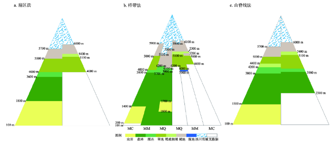
表1 3种坡向划分方法中南、北坡高程范围及其土地覆被类型组成Tab. 1 Elevation range and composition of land cover types on north and south slopes based on three division methods |
| 南北坡划分 | 高程范围(m) | 类型组成 | 无分布的主要类型 | ||||||
|---|---|---|---|---|---|---|---|---|---|
| 南坡 | 北坡 | 南坡 | 北坡 | 南坡 | 北坡 | ||||
| 脊线法 | 96~8844 | 2100~8844 | 一级类型10个 二级类型21个 | 一级类型10个 二级类型20个 | 常绿阔叶林 | ||||
| 样带法 | 珠峰样带 | 146~8844 | 4167~8844 | 一级类型9个 二级类型20个 | 一级类型7个 二级类型10个 | 建设用地 | 森林、灌丛和建设用地 | ||
| 马卡鲁峰样带 | 115~8463 | 3962~8460 | 一级类型10个 二级类型21个 | 一级类型9个 二级类型13个 | 湖泊 | 森林 | |||
| 卓奥友峰样带 | 228~8200 | 3962~8200 | 一级类型9个 二级类型20个 | 一级类型7个 二级类型10个 | 建设用地 | 森林、灌丛和建设用地 | |||
| 扇区法 | 96~8844 | 4000~8844 | 一级类型10个 二级类型21个 | 一级类型8个 二级类型11个 | 森林、灌丛 | ||||
表2 南、北坡土地覆被类型面积组成Tab. 2 Composition of area of land cover types on north and south slopes |
| 类型 | 划分方法 | 南坡 | 北坡 | 南北面积比 | |||||||||||||
|---|---|---|---|---|---|---|---|---|---|---|---|---|---|---|---|---|---|
| 面积(km2) | 百分比(%) | 面积(km2) | 百分比(%) | 南:北 | |||||||||||||
| 农田 | 扇区法 | 374.20 | 44.94 | 5.66 | 1.05 | 66.11:1 | |||||||||||
| 样带法—MM样带 | 304.75 | 27.24 | 23.35 | 2.08 | 13.05:1 | ||||||||||||
| 样带法—MQ样带 | 240.29 | 19.52 | 8.21 | 0.87 | 29.27:1 | ||||||||||||
| 样带法—MC样带 | 406.96 | 31.88 | 9.04 | 1.02 | 45.02:1 | ||||||||||||
| 脊线法* | 7917.95 | 26.91 | 243.64 | 0.99 | 32.50:1 | ||||||||||||
| 森林 | 扇区法 | 342.38 | 41.12 | - | - | - | |||||||||||
| 样带法—MM样带 | 516.34 | 46.16 | - | - | - | ||||||||||||
| 样带法—MQ样带 | 559.99 | 45.50 | - | - | - | ||||||||||||
| 样带法—MC样带 | 406.80 | 31.87 | - | - | - | ||||||||||||
| 脊线法 | 11177 | 37.99 | 262.54 | 1.08 | 42.60:1 | ||||||||||||
| 灌丛 | 扇区法 | 13.62 | 1.64 | - | - | - | |||||||||||
| 样带法—MM样带 | 38.65 | 3.45 | 10.41 | 0.93 | 3.71:1 | ||||||||||||
| 样带法—MQ样带 | 34.85 | 2.83 | - | - | - | ||||||||||||
| 样带法—MC样带 | 36.13 | 2.83 | - | - | - | ||||||||||||
| 脊线法 | 1433.42 | 4.87 | 660.56 | 2.69 | 2.17:1 | ||||||||||||
| 草地 | 扇区法 | 22.17 | 2.66 | 340.08 | 62.99 | 0.07:1 | |||||||||||
| 样带法—MM样带 | 41.97 | 3.75 | 553.23 | 49.38 | 0.08:1 | ||||||||||||
| 样带法—MQ样带 | 43.26 | 3.51 | 522.06 | 55.10 | 0.08:1 | ||||||||||||
| 样带法—MC样带 | 106.15 | 8.31 | 450.42 | 50.94 | 0.24:1 | ||||||||||||
| 脊线法 | 2041.39 | 6.94 | 11886.72 | 48.40 | 0.17:1 | ||||||||||||
| 稀疏植被 | 扇区法 | 10.16 | 1.22 | 69.57 | 12.89 | 0.15:1 | |||||||||||
| 样带法—MM样带 | 28.04 | 2.51 | 96.74 | 8.63 | 0.29:1 | ||||||||||||
| 样带法—MQ样带 | 28.56 | 2.32 | 72.77 | 7.68 | 0.39:1 | ||||||||||||
| 样带法—MC样带 | 66.06 | 5.17 | 35.49 | 4.01 | 1.86:1 | ||||||||||||
| 脊线法 | 1016.77 | 3.46 | 1073.82 | 4.37 | 0.95:1 | ||||||||||||
| 水体 | 扇区法 | 9.50 | 1.14 | 0.01 | 0.00 | 950:1 | |||||||||||
| 样带法—MM样带 | 9.67 | 0.86 | 6.90 | 0.62 | 1.40:1 | ||||||||||||
| 样带法—MQ样带 | 7.90 | 0.64 | 1.43 | 0.15 | 5.52:1 | ||||||||||||
| 样带法—MC样带 | 13.69 | 1.07 | 2.40 | 0.27 | 5.70:1 | ||||||||||||
| 脊线法 | 182.87 | 0.62 | 152.43 | 0.62 | 1.20:1 | ||||||||||||
| 建设用地 | 扇区法 | 0.32 | 0.04 | 1.17 | 0.22 | 0.27:1 | |||||||||||
| 样带法—MM样带 | 0.19 | 0.02 | 0.48 | 0.04 | 0.40:1 | ||||||||||||
| 样带法—MQ样带 | - | - | - | - | - | ||||||||||||
| 样带法—MC样带 | - | - | - | - | - | ||||||||||||
| 脊线法 | 13.68 | 0.05 | 0.79 | 0.00 | 17.30:1 | ||||||||||||
| 裸地 | 扇区法 | 34.37 | 4.13 | 88.18 | 16.33 | 0.39:1 | |||||||||||
| 样带法—MM样带 | 87.34 | 7.81 | 277.88 | 24.80 | 0.31:1 | ||||||||||||
| 样带法—MQ样带 | 176.45 | 14.34 | 192.32 | 20.30 | 0.92:1 | ||||||||||||
| 样带法—MC样带 | 145.79 | 11.42 | 203.95 | 23.06 | 0.71:1 | ||||||||||||
| 脊线法 | 4010.33 | 13.63 | 7750.94 | 31.56 | 0.52:1 | ||||||||||||
| 扇区法 | 3.18 | 0.38 | 14.93 | 2.77 | 0.21:1 | ||||||||||||
| 沼泽湿地 | 样带法—MM样带 | 8.35 | 0.75 | 12.86 | 1.15 | 0.65:1 | |||||||||||
| 样带法—MQ样带 | 9.07 | 0.74 | 22.95 | 2.42 | 0.40:1 | ||||||||||||
| 样带法—MC样带 | 11.91 | 0.93 | 81.77 | 9.25 | 0.15:1 | ||||||||||||
| 脊线法 | 279.49 | 0.95 | 787.95 | 3.21 | 0.36:1 | ||||||||||||
| 冰川雪被** | 扇区法 | 22.83 | 2.74 | 20.26 | 3.75 | 1.13:1 | |||||||||||
| 样带法—MM样带 | 83.27 | 7.44 | 138.51 | 12.36 | 0.60:1 | ||||||||||||
| 样带法—MQ样带 | 130.48 | 10.60 | 127.74 | 13.48 | 1.02:1 | ||||||||||||
| 样带法—MC样带 | 83.11 | 6.51 | 101.19 | 11.44 | 0.82:1 | ||||||||||||
| 脊线法 | 1355.58 | 4.61 | 1740.59 | 7.09 | 0.78:1 | ||||||||||||
| 总计 | 扇区法 | 832.73 | 100.00 | 539.87 | 100.00 | 1.54:1 | |||||||||||
| 样带法—MM样带 | 1118.57 | 100.00 | 1120.36 | 100.00 | 1.00:1 | ||||||||||||
| 样带法—MQ样带 | 1230.85 | 100.00 | 947.48 | 100.00 | 1.30:1 | ||||||||||||
| 样带法—MC样带 | 1276.59 | 100.00 | 884.27 | 100.00 | 1.44:1 | ||||||||||||
| 脊线法 | 29428.43 | 100.00 | 24559.97 | 100.00 | 1.20:1 | ||||||||||||
注:*脊线法数据在Wu等(2017)基础上更新;**指冰川与永久积雪。 |
表3 南、北坡土地覆被类型垂直分布范围(m)Tab. 3 Altitudinal distribution range of land cover types on north and south slopes based on different division methods |
| 类型 | 划分方法 | 南坡 | 北坡 | ||||||||||||||
|---|---|---|---|---|---|---|---|---|---|---|---|---|---|---|---|---|---|
| 海拔范围 | 核心分布带 | 优势带 | 海拔范围 | 核心分布带 | 优势带 | ||||||||||||
| 农田 | 扇区法 | 100~4000 | 600~1700 | 100~1800 | 4000~4500 | 4100~4500 | - | ||||||||||
| 样带法—MQ样带 | 100~4000 | 1100~2200 | 1000~1700 | 4200~4600 | 4200~4500 | - | |||||||||||
| 样带法—MM样带 | 100~4000 | 700~1500 | - | 3900~4500 | 4300~4500 | - | |||||||||||
| 样带法—MC样带 | 200~4000 | 500~1400 | 200~1400 | 4200~4500 | 4400~4500 | - | |||||||||||
| 脊线法 | 96~4300 | 700~1700 | 100~1500 | 2300~4500 | 4100~4500 | - | |||||||||||
| 森林 | 扇区法 | 100~4000 | 500~2000 | 1800~3600 | - | - | - | ||||||||||
| 样带法—MQ样带 | 100~4000 | 1700~3100 | 100~1000 1700~3900 | - | - | - | |||||||||||
| 样带法—MM样带 | 100~4000 | 600~1900 | 100~3700 | - | - | - | |||||||||||
| 样带法—MC样带 | 200~4000 | 700~2200 | 1400~3800 | - | - | - | |||||||||||
| 脊线法 | 100~4000 | 1100~2600 | 1500~3800 | 2100~4000 | 3200~4000 | 2300~3900 | |||||||||||
| 灌丛 | 扇区法 | 1700~5100 | 3300~4200 | 3600~4000 | - | - | - | ||||||||||
| 样带法—MQ样带 | 1700~5000 | 3200~4200 | 3900~4100 | - | - | - | |||||||||||
| 样带法—MM样带 | 1600~5000 | 3700~4200 | 3700~4200 | 4300~5300 | 4500~5000 | - | |||||||||||
| 样带法—MC样带 | 1600~5100 | 3500~4300 | 3800~4000 | - | - | - | |||||||||||
| 脊线法 | 300~4800 | 3400~4600 | 3800~4200 | 2400~4800 | 4200~4800 | 3900~4100 | |||||||||||
| 草地 | 扇区法 | 1600~5900 | 4100~5100 | 4000~5000 | 4000~5100 | 4500~5000 | 4000~5100 | ||||||||||
| 样带法—MQ样带 | 3000~5100 | 4600~5100 | - | 4200~5100 | 4400~4900 | 4200~5100 | |||||||||||
| 样带法—MM样带 | 1500~5100 | 4100~5000 | - | 3900~5100 | 4400~5000 | 4000~5100 | |||||||||||
| 样带法—MC样带 | 2500~5100 | 4300~5000 | 4000~5000 | 4200~5100 | 4300~4700 | 4400~5000 | |||||||||||
| 脊线法 | 1400~5100 | 4400~5000 | 4400~5000 | 2500~5100 | 4400~5000 | 4100~5100 | |||||||||||
| 稀疏植被 | 扇区法 | 3000~5300 | 4400~5300 | - | 4600~5400 | 5000~5400 | 5100~5400 | ||||||||||
| 样带法—MQ样带 | 3000~5300 | 4500~5300 | - | 4700~5300 | 5000~5300 | 5100~5300 | |||||||||||
| 样带法—MM样带 | 3300~5300 | 4100~4800 | - | 4700~5300 | 5200~5300 | 5100~5300 | |||||||||||
| 样带法—MC样带 | 3100~5300 | 4500~5200 | - | 4700~5300 | 5200~5300 | 5200~5300 | |||||||||||
| 脊线法 | 2100~5300 | 4600~5300 | - | 4000~5400 | 5000~5400 | 5100~5400 | |||||||||||
| 水体 | 扇区法 | 100~2500 4200~5300 | 100~500 | - | 4200-4500 5000~5800 | 4200~4400 | - | ||||||||||
| 样带法—MQ样带 | 100~800 1400-2200 4600~5400 | 4900~5400 | - | 4200~4400 5700~6100 | 4200~4300 | - | |||||||||||
| 样带法—MM样带 | 100~900 3700~5300 | 100~500 | - | 4200~5300 | 4200~4300 4800~5000 | - | |||||||||||
| 样带法—MC样带 | 200~1800 4200~5300 | 200~700 | - | 4200~4400 5500~5800 | 4300~4400 | - | |||||||||||
| 脊线法 | 96~2900 3700~5300 | 200~700 4900~5300 | - | 2200~5300 | 4100~4600 | - | |||||||||||
| 建设用地 | 扇区法 | 1000~1700 | 1100~1300 1500~1600 | - | 4200~4400 | 4300~4400 | - | ||||||||||
| 样带法—MQ样带 | - | - | - | - | - | - | |||||||||||
| 样带法—MM样带 | 1500~1700 | 1500~1600 | - | 4200~4400 | 4300~4400 | - | |||||||||||
| 样带法—MC样带 | - | - | - | - | - | - | |||||||||||
| 脊线法 | 400~2400 | 1000~1600 | - | 4200~4400 | 4200~4400 | - | |||||||||||
| 裸地 | 扇区法 | > 3000 | 4800~5900 | 5000~5700 | > 4200 | 5100~5600 | 5400~6000 | ||||||||||
| 样带法MQ样带 | > 3000 | 5000~5900 | 4100~5500 | > 4200 | 5000~5900 | 5300~6100 | |||||||||||
| 样带法MM样带 | > 3400 | 4300~5200 | 4200~5100 | > 4300 | 5100~5700 | 5300~5900 | |||||||||||
| 样带法MC样带 | > 3100 | 5000~5500 | 5000~5900 | > 4300 | 5000~5800 | 5000~5200 5300~6100 | |||||||||||
| 脊线法 | > 1100 | 4700~5700 | 4200~4400 5000~5700 | > 3000 | 5000~5700 | 5400~6000 | |||||||||||
| 沼泽湿地 | 扇区法 | < 2800 | 100~500 | - | 4000~5000 | 4200~4500 | - | ||||||||||
| 样带法MQ样带 | < 4900 | 100~1000 | - | 4200~5200 | 4200~4500 | - | |||||||||||
| 样带法MM样带 | 100~4500 | 400~1100 | - | 3900~5300 | 4000~4400 | 3900~4000 | |||||||||||
| 样带法MC样带 | < 5200 | 200~1400 | - | < 5500 | 4300~4400 | - | |||||||||||
| 脊线法 | < 5100 | 200~1400 | - | 3500~5300 | 4100~4400 | - | |||||||||||
| 冰川雪被 | 扇区法 | > 4400 | 5200~5900 | > 5700 | > 5100 | 6000~6600 | > 6000 | ||||||||||
| 样带法MQ样带 | > 4800 | 5100~5800 | > 5500 | > 5400 | 6000~6700 | > 6100 | |||||||||||
| 样带法MM样带 | > 4100 | 5000~6000 | > 5100 | > 4300 | 5200~6300 | > 5900 | |||||||||||
| 样带法MC样带 | > 4600 | 4700~5700 | > 5900 | > 5400 | 6000~6600 | > 6100 | |||||||||||
| 脊线法 | > 4000 | 5100~5900 | > 5700 | > 3800 | 5400~6300 | > 6000 | |||||||||||
表4 珠穆朗玛峰南北坡土地覆被与气候和土壤带类型垂直分布关系Tab. 4 Comparison of altitudinal distribution of land cover, climate and soil on south and north slopes of Mt. Qomolangma |
| 珠峰气候垂直带a | 珠峰土壤垂直带a | 珠峰(扇区法)土地覆被优势带b | ||||||
|---|---|---|---|---|---|---|---|---|
| 海拔(m) | 垂直气候带类型 | 海拔(m) | 垂直土壤带类型 | 优势带 | 土地覆被类型 | |||
| 南坡 | 1600~2500 | 山地亚热带 | 1600~2500 | 山地黄棕壤 | 100~1800 | 农田 | ||
| 2500~3100 | 山地暖温带 | 2400~3100 | 山地酸性棕壤 | 1800~3600 | 森林 | |||
| 3100~3900 | 山地寒温带 | 3100~4100 | 山地漂灰土 | 3600~4000 | 灌丛 | |||
| 3900~4700 | 亚高山寒带 | 4100~4500 | 亚高山灌丛草甸土 | |||||
| 4100~4500 | 亚高山草甸土 | 4000~5000 | 草地 | |||||
| 4500~4800 | 高山草甸土 | |||||||
| 4700~5500 | 高山寒冻带 | 4800~5600 | 高山寒漠土 | 5000~5700 | 裸地 | |||
| > 5500 | 高山冰雪带 | > 5600 | 冰和雪 | > 5700 | 冰川雪被 | |||
| 北坡 | 4000~5000 | 高原寒冷带 | 4400~4700 | 亚高山草原土 | 4000~5100 | 草地 | ||
| 5000~6000 | 高山寒冻带 | 4700~5200 | 高山草甸草原土 | 5100~5400 | 稀疏植被 | |||
| 5200~5500 | 高山寒漠土 | 5400~6000 | 裸地 | |||||
| > 6000 | 高山冰雪带 | > 5500 | 冰和雪 | > 6000 | 冰川雪被 | |||
注:a文献[21]数据;b本文数据。 |
表5 珠穆朗玛峰土地覆被与植被垂直分布比较Tab. 5 Comparison of altitudinal distribution of land cover and vegetation on the slope of Mt. Qomolangma |
| 珠峰(扇区法)土地覆被类型垂直分布a | 珠峰植被垂直分带b | |||||||||||||
|---|---|---|---|---|---|---|---|---|---|---|---|---|---|---|
| 分布范围 (m) | 核心分布 (m) | 优势带 (m) | 土地覆被类型 及构成信息 | 分布范围 (m) | 植被类型及组成 | |||||||||
| 南坡 | 100~4000 | 600~1700 | 100~1800 | 农田 < 1000 m,农田—常绿阔叶林交错分布。 1400~1800 m,农田—常绿落叶阔叶混交林交错分布。 农作物主要有水稻、玉米、小麦、黍类、土豆。 | < 1000(1200) | 季雨林带 娑罗双树季雨林带的上限一般在海拔1000 m左右,局部达1200 m。 | ||||||||
| 1000~2500 | 常绿阔叶林带 通常海拔2000 m以下以印栲、木荷为主,2000 m以上中国境内被铁椆、粗穗石柯替代,尼泊尔境内被L.spicata为主的山地常绿阔叶林替代。 | |||||||||||||
| 100~4000 | 500~2000 | 1800~3600 | 森林 常绿落叶阔叶混交林 | |||||||||||
| 2500~3000 (3100) | 山地针叶阔叶(常绿、落叶)混交林带 局部上限达海拔3100m,是整个南坡植被垂直带谱中幅度较窄的一个带。主要由铁杉和高山栎的纯林或混交林组成。 | |||||||||||||
| 3000~3800 (4100) | 亚高山针叶林带 主要由冷杉林构成。阴坡分布冷杉林和糙皮桦林,阳坡高山栎林、还有桧柏梳林和灌丛。 | |||||||||||||
| 1700~5100 | 3300~4200 | 3600~4000 | 灌丛 优势种以钟花杜鹃、高山柏和刚毛杜鹃等为主。 | 3800(4100)~4500 | 高山灌丛 南坡以扁芒草禾草草甸和桧柏灌丛为主。北坡以杜鹃为主的小叶矮灌丛。 | |||||||||
| 1600~5900 | 4100~5100 | 4000~5000 | 草地 伴有撂荒地。 | 4500~5200 | 高山草甸 冰草苔原和多种垫状植物、杂草类的高山草甸。 | |||||||||
| 3000~5300 | 4400~5300 | 稀疏植被 | ||||||||||||
| > 3000 | 4800~5900 | 5000~5700 | 裸地 | 5200~5500 (5600) | 地衣砾石带 地面覆盖砾石、冰碛物,表面生有地图黄绿衣、粗糙碟衣、鸡皮衣、裂叶石耳、红橙衣、菊叶梅衣印等。 | |||||||||
| > 4400 | 5200~5900 | > 5700 | 冰川雪被 | > 5500(5600) | 永久冰雪带 | |||||||||
| 100~2500 4200~5300 | 100~500 | 水体 河流与湖泊 | ||||||||||||
| < 2800 | 100~500 | 沼泽湿地 | ||||||||||||
| 1000~1700 | 1100~1300 1500~1600 | 建设用地 | ||||||||||||
| 北坡 | 4000~4500 | 4100~4500 | 4000~5100 | 草地 以高寒草地分布为主,在河谷中分布农田。 | 3900~4400 | 草原带 以白草、固砂草草原为主。 | ||||||||
| 4000~5100 | 4500~5000 | 草地 高寒草原,以藏沙蒿,藏白蒿,细裂叶莲蒿,固沙草等为主。 | 4400~5000 | 高山草原带 以紫花针茅草原为主。 | ||||||||||
| 北坡 | 4600~5400 | 5000~5400 | 5100~5400 | 稀疏植被 主要植物为垫状点地梅,山地蚤缀,绢毛棘豆。 | 5000~5700 | 高山草甸与稀疏垫状植被带 分布冰川苔原、嵩草草甸,并且杂有多种垫状植物。 | ||||||||
| > 4200 | 5100-5600 | 5400~6000 | 裸地 | |||||||||||
| 5700~5800 (6200) | 地衣、砾石带 | |||||||||||||
| > 5100 | 6000~6600 | > 6000 | 冰川雪被 | >5800~6200 | 永久冰雪带 | |||||||||
| 4200~4500 5000~5800 | 4200~4400 | 水体 河流与湖泊 | ||||||||||||
| 4000~5000 | 4200~4500 | 沼泽湿地 | ||||||||||||
| 4200~4400 | 4300~4400 | 建设用地 | ||||||||||||
注:a本文数据;b文献[22]数据。 |
王秀红、摆万奇和朱会义先生在论文撰写和修改中提出了宝贵的建议,刘林山和王兆锋等在研究分析中给予支持和帮助,特此感谢。
| [1] |
|
| [2] |
|
| [3] |
|
| [4] |
|
| [5] |
|
| [6] |
|
| [7] |
|
| [8] |
|
| [9] |
|
| [10] |
[ 牟长城 . 长白山落叶松和白桦—沼泽生态交错带群落演替规律研究. 应用生态学报, 2003,14(11):1813-1819.]
|
| [11] |
|
| [12] |
|
| [13] |
|
| [14] |
[ 许娟, 张百平, 谭靖 , 等. 青藏高原植被垂直带与气候因子的空间关系. 山地学报, 2009,27(6):663-670.]
|
| [15] |
[ 姚永慧, 徐美, 张百平 . 青藏高原增温效应对垂直带谱的影响. 地理学报, 2015,70(3):407-419.]
|
| [16] |
|
| [17] |
|
| [18] |
[ 次旦伦珠 . 珠穆朗玛峰自然保护区概况. 中国藏学, 1997(1):3-22.]
|
| [19] |
|
| [20] |
|
| [21] |
Mount Qomolangma Group of Nanjing Institute of Soil Research, Chinese Academy of Sciences. The characteristics of soil geographical distribution in the Mount Qomolangma area//Tibet Scientific Expedition Team of the Chinese Academy of Sciences. A Report on the Scientific Investigation of the Mount Qomolangma Area. Beijing: Science Press, 1975.
[ 中国科学院南京土壤研究所珠峰组. 珠穆朗玛峰地区土壤地理分布特点//中国科学院西藏科学考察队. 珠穆朗玛峰地区科学考察报告. 北京: 科学出版社, 1975.]
|
| [22] |
[ 张经炜, 姜恕 . 珠穆朗玛峰地区的植被垂直分带及其与水平地带关系的初步研究. 植物学报, 1973,15(2):221-236.]
|
| [23] |
[ 聂勇, 张镱锂, 刘林山 , 等. 近30年珠穆朗玛峰国家自然保护区冰川变化的遥感监测. 地理学报, 2010,65(1):13-28.]
|
/
| 〈 |
|
〉 |
