
南北过渡带1∶5万植被类型图遥感制图案例研究
|
姚永慧(1975-), 女, 湖北安陆人, 博士, 副研究员, 研究方向地理时空数据分析。E-mail: yaoyh@lreis.ac.cn |
收稿日期: 2018-12-17
要求修回日期: 2019-12-19
网络出版日期: 2020-05-25
基金资助
国家自然科学基金项目(41871350)
国家自然科学基金项目(41571099)
科技基础资源调查项目(2017FY100900)
版权
Compilation of 1∶50000 vegetation type map with remote sensing images based on mountain altitudinal belts of Taibai Mountain in the north-south transitional zone of China
Received date: 2018-12-17
Request revised date: 2019-12-19
Online published: 2020-05-25
Supported by
National Natural Science Foundation of China(41871350)
National Natural Science Foundation of China(41571099)
Scientific and Technological Basic Resources Survey Project(2017FY100900)
Copyright
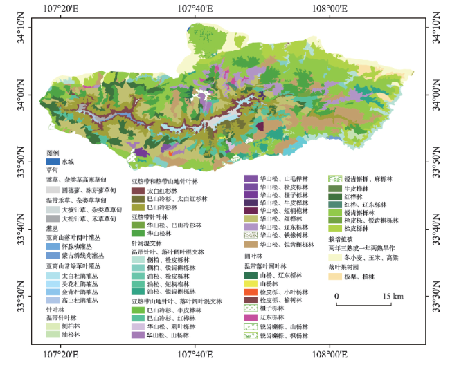
编制南北过渡带地区1∶25万和典型山地1∶5万植被类型图是南北过渡带综合科学考察的主要任务之一。以往植被类型图的编制都是采用大量的地面调查来完成的,地面调查方法虽然精确,但费时费力,并且由于自然条件的限制,地面调查往往只能覆盖较小的范围。遥感数据因为其全覆盖的优势,可以很好地弥补样方调查的局限性,但目前大范围的植被类型遥感信息提取尤其是自动提取方面仍然存在一定的困难和瓶颈。本文以1∶5万太白山植被类型图的编制为例,利用多源多时相的高分辨率遥感数据,结合地面调查数据、以往的各种比例尺的植被类型图数据和森林资源调查数据等,探讨并研究基于山地垂直带谱的中大比例尺植被类型图的遥感提取方法和制图方法。研究结果表明:① 山地植被垂直带谱可以有效地支持1∶5万山区植被类型图的遥感制图。利用太白山植被垂直带谱和1∶1万数字表面模型数据(DSM)可以生成具有垂直带谱信息的地形约束因子;将地形约束因子与多源多时相高分辨率遥感数据、地面调查数据、以往的小比例尺植被类型图数据等相结合,可以有效提取各级植被类型,从而实现中大比例尺植被类型图的编制。② 典型山地1∶5万植被类型图的遥感制图基本流程为植被型组解译→植被群系组、群系、亚群系解译→植被型、植被亚型分类,采取自上而下和自下而上相结合的分类方法来分类。本文的研究成果可以为中大比例尺植被类型图的编制提供示范和科学依据。
姚永慧 , 张俊瑶 , 索南东主 . 南北过渡带1∶5万植被类型图遥感制图案例研究[J]. 地理学报, 2020 , 75(3) : 620 -630 . DOI: 10.11821/dlxb202003013
The compilation of 1:250000 vegetation type map in the north-south transitional zone and 1:50000 vegetation type maps in typical mountainous areas is one of the main tasks of integrated scientific investigation of the north-south transitional zone of China. In the past, vegetation type maps were compiled by a large number of ground field surveys. Although the field survey method is accurate, it is not only time-consuming, but also only covers a small area due to the limitations of physical environment conditions. Remote sensing data can make up for the limitation of field survey because of its full coverage. However, there are still some difficulties and bottlenecks in the extraction of remote sensing information of vegetation types, especially in the automatic extraction. As an example of the compilation of 1:50000 vegetation type map, this paper explores and studies the remote sensing extraction and mapping methods of vegetation type with medium and large scales based on mountain altitudinal belts of Taibai Mountain, using multi-temporal high resolution remote sensing data, ground survey data, previous vegetation type map and forest survey data. The results show that: (1) mountain altitudinal belts can effectively support remote sensing classification and mapping of 1:50000 vegetation type map in mountain areas. Terrain constraint factors with mountain altitudinal belt information can be generated by mountain altitudinal belts, 1:10000 Digital Surface Model (DSM) data of Taibai Mountain. In combination of the terrain constraint factors with multi-temporal and high-resolution remote sensing data, ground survey data and previous small-scale vegetation type map data, the vegetation types at all levels can be extracted effectively. (2) The basic remote sensing interpretation and mapping process for typical mountains is interpretation of vegetation type-group→interpretation of vegetation group & subgroup→interpretation and classification of vegetation type & subtype, which is a combination method of top-down method and bottom-up method, not the top-down or the bottom-up classification according to the level of mapping units. The results of this study provide a demonstration and scientific basis for the compilation of large and medium scale vegetation type maps.
表1 太白山高分遥感数据Tab. 1 Remote sensing images of Taibai Mountain |
| 传感器 | 获取时间 | 分辨率(m) | 传感器 | 获取时间 | 分辨率(m) |
|---|---|---|---|---|---|
| GF2 | 2017年8月3日 | 0.8 | ZY3 | 2017年9月28日 | 2 |
| 2017年9月7日 | 0.8 | 2017年8月5日 | 2 | ||
| 2017年9月7日 | 0.8 | 2016年8月31日 | 2 | ||
| 2017年8月3日 | 0.8 | 2018年2月3日 | 2 | ||
| GF1 | 2016年8月28日 | 2 | 2018年2月8日 | 2 | |
| 2016年11月30日 | 2 | 2017年9月28日 | 2 | ||
| 2017年10月28日 | 2 | 2017年8月5日 | 2 | ||
| 2017年2月12日 | 2 | 2016年8月31日 | 2 | ||
| 2016年8月28日 | 2 | 2018年2月3日 | 2 | ||
| 2016年11月30日 | 2 | 2018年2月8日 | 2 | ||
| 2017年10月28日 | 2 | 2017年7月14日 | 2 | ||
| 2017年2月12日 | 2 | 2016年9月22日 | 2 | ||
| 2017年8月8日 | 16 | 2016年9月22日 | 2 | ||
| 2015年1月20日 | 16 | 2016年11月10日 | 2 | ||
| 2015年10月1日 | 16 | 2017年11月4日 | 2 | ||
| 2017年7月1日 | 16 | 2017年1月13日 | 2 | ||
| 2017年2月12日 | 16 | 2017年7月14日 | 2 | ||
| ZY3 | 2017年11月4日 | 2 | 2016年9月22日 | 2 | |
| 2017年1月13日 | 2 | 2016年11月10日 | 2 |
表2 太白山植被分类系统Tab. 2 Vegetation classification system of Taibai Mountain |
| 植被型组 | 植被型、亚型 | 植被群系组、群系和亚群系 |
|---|---|---|
| 草甸 | 蒿草、杂类草高寒草甸 | 圆穗蓼、珠芽蓼草甸 |
| 温带禾草、杂类草草甸 | 大批针草、禾草草甸 | |
| 大披针草、杂类草草甸 | ||
| 灌丛 | 亚高山落叶阔叶灌丛 | 怀腺柳灌丛 |
| 蒙古绣线菊灌丛 | ||
| 亚高山常绿革叶灌丛 | 高山杜鹃灌丛 | |
| 金背杜鹃灌丛 | ||
| 太白杜鹃灌丛 | ||
| 头花杜鹃灌丛 | ||
| 针叶林 | 温带针叶林 | 侧柏林 |
| 油松林 | ||
| 亚热带和热带山地针叶林 | 巴山冷杉、太白红杉林 | |
| 巴山冷杉林 | ||
| 太白红杉林 | ||
| 亚热带针叶林 | 华山松、巴山冷杉林 | |
| 华山松林 | ||
| 针阔混交林 | 温带针叶、落叶阔叶混交林 | 侧柏、锐齿槲栎林 |
| 侧柏、栓皮栎林 | ||
| 油松、短柄枹林 | ||
| 油松、锐齿槲栎林 | ||
| 油松、栓皮栎林 | ||
| 亚热带山地针叶、落叶阔叶混交林 | 巴山冷杉、红桦林 | |
| 巴山冷杉、牛皮桦林 | ||
| 华山松、刺叶栎林 | ||
| 华山松、短柄枹林 | ||
| 华山松、红桦林 | ||
| 华山松、橿子栎林 | ||
| 华山松、辽东栎林 | ||
| 华山松、牛皮桦林 | ||
| 华山松、锐齿槲栎林 | ||
| 华山松、山毛榉林 | ||
| 华山松、山杨林 | ||
| 华山松、栓皮栎林 | ||
| 华山松、铁橡树林 | ||
| 阔叶林 | 温带落叶阔叶林 | 红桦、辽东栎林 |
| 红桦林 | ||
| 橿子栎林 | ||
| 辽东栎林 | ||
| 牛皮桦林 | ||
| 锐齿槲栎、枫杨林 | ||
| 锐齿槲栎、麻栎林 | ||
| 锐齿槲栎、山杨林 | ||
| 锐齿槲栎、栓皮栎林 | ||
| 锐齿槲栎林 | ||
| 山杨、辽东栎林 | ||
| 山杨林 | ||
| 栓皮栎、锐齿槲栎林 | ||
| 栓皮栎、小叶杨林 | ||
| 栓皮栎、榆树林 | ||
| 栓皮栎林 | ||
| 栽培植被 | 两年三熟或一年两熟旱作 | 冬小麦、玉米、高粱 |
| 果树园 | 板栗、核桃 |
| [1] |
Chinese Vegetation Map Editorial Committee, Chinese Academy of Sciences. Vegetation and its Geographical Patterns in China: Instructions for Vegetation Maps of the People's Republic of China. Beijing: Geology Press, 2007.
[ 中国科学院中国植被图编辑委员会. 中国植被及其地理格局: 中华人民共和国植被图说明书. 北京: 地质出版社, 2007.]
|
| [2] |
Chinese Vegetation Map Editorial Committee, Chinese Academy of Sciences. Atlas of 1:1000000 Chinese Vegetation. Beijing: Science Press, 2000.
[ 中国科学院中国植被图编辑委员会. 1:1000000中国植被图集. 北京: 科学出版社, 2000.]
|
| [3] |
[ 钱崇澍 . 中国植被区划草案. 北京: 科学出版社, 1956.]
|
| [4] |
[ 侯学煜, 马溶之 . 中国植被—土壤分区图. 北京: 地图出版社, 1956.]
|
| [5] |
[ 侯学煜, 孙世洲, 张经炜 , 等. 中华人民共和国植被图(1:4000000). 北京: 地图出版社, 1979.]
|
| [6] |
[ 刘纪远 . 中国资源环境遥感宏观调查与动态研究. 北京: 中国科学技术出版社, 1996.]
|
| [7] |
|
| [8] |
[ 刘纪远, 张增祥, 庄大方 , 等. 20世纪90年代中国土地利用变化时空特征及其成因分析. 地理研究, 2003,22(1):1-12.]
|
| [9] |
|
| [10] |
|
| [11] |
[ 雷光斌, 李爱农, 谭剑波 , 等. 基于多源多时相遥感影像的山地森林分类决策树模型研究. 遥感技术与应用, 2016,31(1):31-41.]
|
| [12] |
[ 贾明明, 任春颖, 刘殿伟 , 等. 基于环境星与MODIS时序数据的面向对象森林植被分类. 生态学报, 2014,34(24):7167-7174.]
|
| [13] |
[ 胡博, 鞠洪波, 刘华 , 等. 基于证据理论组合多分类规则实现大区域植被遥感分类研究. 林业科学研究, 2017,30(2):194-199.]
|
| [14] |
|
| [15] |
[ 骆剑承, 吴国军, 李均力 , 等. 遥感图谱认知. 北京: 科学出版社, 2017.]
|
| [16] |
|
| [17] |
[ 吴田军, 骆剑承, 夏列钢 , 等. 迁移学习支持下的遥感影像对象级分类样本自动选择方法. 测绘学报, 2014,43(9):908-916.]
|
| [18] |
[ 张静静, 朱文博, 赵芳 , 等. 山地平原过渡带地形特征及其对景观格局的影响: 以太行山淇河流域为例. 中国科学: 地球科学, 2018,48(4):476-486.]
|
| [19] |
[ 刘宪锋, 潘耀忠, 朱秀芳 , 等. 2000—2014年秦巴山区植被覆盖时空变化特征及其归因. 地理学报, 2015,70(5):705-716.]
|
| [20] |
[ 张晓东, 朱文博, 张静静 , 等. 伏牛山地森林植被物候及其对气候变化的响应. 地理学报, 2018,73(1):41-53.]
|
| [21] |
[ 夏列钢 . 耦合“图—谱”特征的遥感影像自动分类方法研究[D]. 杭州: 浙江工业大学, 2011.]
|
| [22] |
[ 李海宁 . 太白山北坡植物物种多样性及其垂直分布格局研究[D]. 西安: 陕西师范大学, 2007.]
|
| [23] |
[ 方正, 高淑贞 . 秦岭太白山南北坡的植被垂直带谱. 植物生态学与地植物学丛刊, 1963,1:162-163.]
|
| [24] |
[ 岳明 . 秦岭植物垂直带谱完整复杂. 森林与人类, 2015(2):76-81.]
|
| [25] |
[ 李治, 杨晓梅, 孟樊 , 等. 物候特征辅助下的随机森林宏观尺度土地覆盖分类方法研究. 遥感信息, 2013,28(6):48-55.]
|
| [26] |
|
/
| 〈 |
|
〉 |
