
基于大数据的极端暴雨事件下城市道路交通及人群活动时空响应
|
易嘉伟(1988-), 男, 湖南衡阳人, 博士, 助理研究员, 主要从事地理数据挖掘研究。E-mail: yijw@lreis.ac.cn |
收稿日期: 2018-08-31
要求修回日期: 2019-10-08
网络出版日期: 2020-05-25
基金资助
国家重点研发计划(2017YFB0503605)
中国科学院战略性先导科技专项(A类)(XDA19040501)
版权
Spatio-temporal responses of urban road traffic and human activities in an extreme rainfall event using big data
Received date: 2018-08-31
Request revised date: 2019-10-08
Online published: 2020-05-25
Supported by
National Key Research and Development Program of China(2017YFB0503605)
Strategic Priority Research Program of the Chinese Academy of Sciences(XDA19040501)
Copyright
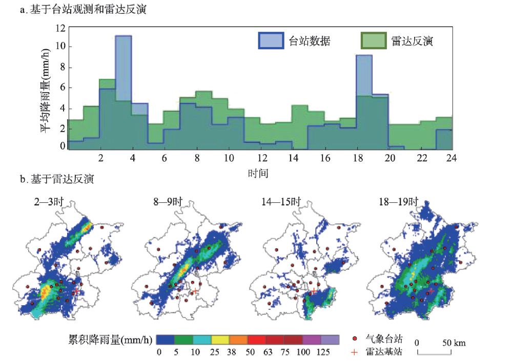
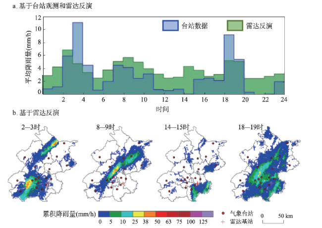
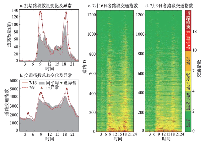
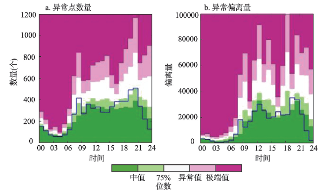
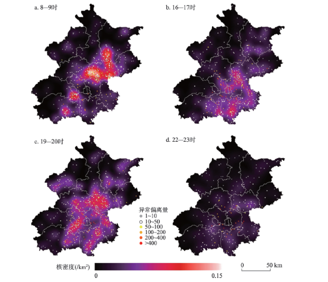
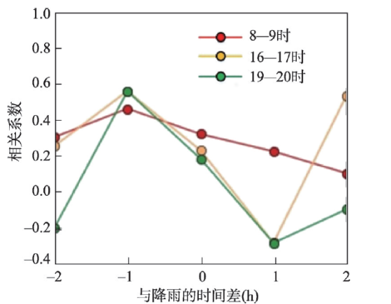
随着全球气候变化加剧,极端降雨增多,暴雨内涝灾害频发,严重威胁城市的可持续发展。快速掌握暴雨给城市交通及人群的影响,有助于提高灾害应急管理水平和事件响应能力。利用实时动态的交通路况信息和手机定位请求数据,通过一种融合STL时序分解技术与极端学生化偏差统计检验的时间序列异常探测方法,监测和分析暴雨内涝灾害事件中,城市道路交通和人群活动的时空响应特征,并以2018年7月16日发生在北京的极端暴雨事件为例开展实证研究。研究结果显示,在降雨集中的早、晚高峰两个时段(8—9时、18—19时),市区的拥堵道路数量超出往常水平最高可达150%,异常检测分析显示拥堵道路数量和交通拥堵指数均达到异常甚至极端水平。人群活动的异常响应分析结果显示,暴雨事件引起定位请求量异常升高、异常点增多,且异常点的空间分布与1 h前的降雨量分布存在较高相关性。以上结果不仅证明了大数据及异常检测方法对于快速洞察暴雨事件对城市交通及人群影响的有效性,也为城市暴雨内涝灾害的应急响应与管理提供了新的技术手段。
易嘉伟 , 王楠 , 千家乐 , 马廷 , 杜云艳 , 裴韬 , 周成虎 , 涂文娜 , 刘张 , 王会蒙 . 基于大数据的极端暴雨事件下城市道路交通及人群活动时空响应[J]. 地理学报, 2020 , 75(3) : 497 -508 . DOI: 10.11821/dlxb202003005
As global climate change intensifies, extreme rainfalls and floods become more frequent and pose a serious threat to urban sustainable development. Fast assessment of the rainfall disaster impact upon urban traffic and population plays an important role in improving disaster emergency management and incident response capabilities. This study adopts a time series anomaly detection method to discover and quantify the impact of rainfall-triggered flood on road traffic and human activities using real-time traffic condition information and mobile phone location request data. The anomaly detection method combines the STL time series decomposition technique and the extreme student deviation statistics to identify the response characteristics of traffic data and location requests during the event. The extreme rainfall event that occurred in Beijing on July 16, 2018 is used as a case study to examine the method effectiveness. The results show that the precipitation peaked in the morning and evening rush hours, during which the number of congested roads exceeded the average level by up to 150%. The anomaly detection analysis indicates that the number of congested roads and the traffic congestion index reached the outlier level. The anomaly analysis of human activity responses shows that the heavy rainfall event also caused an abnormal increase in the number of location requests, and the spatial distribution of the anomalous grids was highly correlated with the rainfall distribution one hour before. The above results not only prove the effectiveness of the big data and the anomaly detection method in understanding the impact of heavy rainfall events on urban traffic and population, but also provide new means for urban emergency response and management against rainfall disasters.
Key words: heavy rainfall; urban flood; road traffic; human activity; big data; anomaly detection
表1 道路交通指数分级标准Tab. 1 Index categorization of road traffic |
| 拥堵指数 | 0~2 | 2~4 | 4~7 | 7~10 | 10~18 | 18及以上 |
|---|---|---|---|---|---|---|
| 拥堵分级 | 畅通 | 基本畅通 | 轻度拥堵 | 拥堵 | 严重拥堵 | 道路瘫痪 |
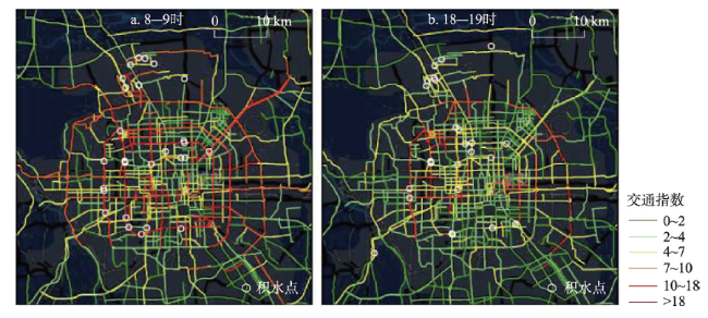
图4 早、晚高峰时段北京城区路网交通指数与积水点分布情况Fig. 4 Road traffic and inundation distribution during morning and evening rush hours |
表2 早晚高峰时段道路积水点及周边道路拥堵情况Tab. 2 Statistics of road congestion near inundation spots during morning and evening rush hours |
| 时段 | 积水点数量* | 邻近道路交通指数** | 邻近道路交通指数异常偏离量** |
|---|---|---|---|
| 8—9时 | 28 | 9.91 | 3.20 |
| 18—19时 | 25 | 6.99 | 2.10 |
注:① *积水点数据主要来自北京交通广播、新闻媒介、网友等在微博及互联网媒体上发布的图文信息整理并地理编码而来,可能存在未统计到的积水路段;② **表中的交通指数及异常偏离量指数均为积水点周边邻近道路的统计均值。 |
| [1] |
[ 王迎春, 郑大玮, 李青春 . 城市气象灾害. 北京: 气象出版社, 2009.]
|
| [2] |
|
| [3] |
[ 扈海波 . 城市暴雨积涝灾害风险突增效应研究进展. 地理科学进展, 2016,35(9):1075-1086.]
|
| [4] |
[ 叶超凡, 张一驰, 程维明 , 等. 北京市区快速城市化进程中的内涝现状及成因分析. 中国防汛抗旱, 2018,28(2):19-25.]
|
| [5] |
[ 王炜, 陈仁泽, 刘毅 , 等. 大城市为何频频内涝. 人民日报, 2012-07-24. ]
|
| [6] |
State Flood Control and Drought Relief Headquarters, Ministry of Water Resources. China Water and Drought Disaster Bulletin 2017. Beijing: Sinomap Press, 2017.
[ 国家防汛抗旱总指挥部, 中华人民共和国水利部. 中国水旱灾害公报2017. 北京: 中国地图出版社, 2017.]
|
| [7] |
[ 解以扬, 韩素芹, 由立宏 , 等. 天津市暴雨内涝灾害风险分析. 气象科学, 2004,24(3):342-349.]
|
| [8] |
[ 景垠娜, 尹占娥, 殷杰 , 等. 基于GIS的上海浦东新区暴雨内涝灾害危险性分析. 灾害学, 2010,25(2):58-63.]
|
| [9] |
[ 顾孝天, 李宁, 周扬 , 等. 北京“7·21”暴雨引发的城市内涝灾害防御思考. 自然灾害学报, 2013,22(2):1-6.]
|
| [10] |
[ 张冬冬, 严登华, 王义成 , 等. 城市内涝灾害风险评估及综合应对研究进展. 灾害学, 2014,29(1):144-149.]
|
| [11] |
[ 殷杰, 许世远, 经雅梦 , 等. 基于洪涝情景模拟的城市公共服务灾害应急响应空间可达性评价: 以医疗急救为例. 地理学报, 2018,73(9):1737-1747.]
|
| [12] |
[ 孙超, 钟少波, 邓羽 . 基于暴雨内涝灾害情景推演的北京市应急救援方案评估与决策优化. 地理学报, 2017,72(5):804-816.]
|
| [13] |
[ 尹占娥, 许世远, 殷杰 , 等. 基于小尺度的城市暴雨内涝灾害情景模拟与风险评估. 地理学报, 2010,65(5):553-562.]
|
| [14] |
|
| [15] |
|
| [16] |
|
| [17] |
|
| [18] |
|
| [19] |
|
| [20] |
|
| [21] |
[ 刘望保, 石恩名 . 基于ICT的中国城市间人口日常流动空间格局: 以百度迁徙为例. 地理学报, 2016,71(10):1667-1679.]
|
| [22] |
[ 甄峰, 秦萧 . 大数据在智慧城市研究与规划中的应用. 国际城市规划, 2014,29(6):44-50.]
|
| [23] |
[ 程昌秀, 史培军, 宋长青 , 等. 地理大数据为地理复杂性研究提供新机遇. 地理学报, 2018,73(8):1397-1406.]
|
| [24] |
|
| [25] |
|
| [26] |
[ 吴先华, 肖扬, 李廉水 , 等. 大数据融合的城市暴雨内涝灾害应急管理评述. 科学通报, 2017,62(9):920-927.]
|
| [27] |
|
| [28] |
State Flood Control and Drought Relief Headquarters, Ministry of Water Resources. China Water and Drought Disaster Bulletin 2012. Beijing: China Water & Power Press, 2012.
[ 国家防汛抗旱总指挥部, 中华人民共和国水利部. 中国水旱灾害公报2012. 北京: 中国水利水电出版社, 2012.]
|
| [29] |
[ 杨进怀, 丁跃元, 刘大根 . 北京“7·21”特大暴雨自然灾害的启示与对策思考. 中国水利, 2012,17:29-31.]
|
| [30] |
Beijing Municipal Bureau of Statistics, Survey Office of the National Bureau of Statistics in Beijing. Beijing Statistical Yearbook 2017. Beijing: China Statistics Press, 2018.
[ 北京市统计局, 国家统计局北京调查总队. 北京统计年鉴-2017. 北京: 中国统计出版社, 2018.]
|
| [31] |
|
| [32] |
|
| [33] |
|
| [34] |
|
| [35] |
|
/
| 〈 |
|
〉 |