
理解地理“耦合”实现地理“集成”
|
宋长青(1961-), 男, 黑龙江人, 教授, 主要从事地理学研究范式、地理区域综合研究方法等方面的研究。E-mail: songcq@bnu.edu.cn |
收稿日期: 2019-04-19
要求修回日期: 2019-12-19
网络出版日期: 2020-03-25
基金资助
第二次青藏高原综合考察研究(2019QZKK0608)
美丽中国生态文明建设科技工程专项(XDA23100303)
版权
Understanding geographic coupling and achieving geographic integration
Received date: 2019-04-19
Request revised date: 2019-12-19
Online published: 2020-03-25
Supported by
The Second Tibetan Plateau Scientific Expedition and Research Program (STEP)(2019QZKK0608)
The Strategic Priority Research Program of the Chinese Academy of Sciences(XDA23100303)
Copyright
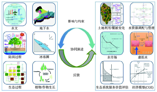
“耦合”作为物理学的经典概念,为许多学科提供了一套阐述多主体相互作用的思路和方法。“集成”不是来自特定学科,但因其高度的概括能力被广泛应用于自然和人文科学领域。地球科学是应用这两个概念最多的学科之一。地理学作为自然与人文交叉学科,具有区域性、综合性和复杂性特征。在使用耦合概念时,不同地理分支具有不同的理解,为此,地理学者有必要明确界定不同学科、不同情景下耦合概念的内涵,从而更准确地探索陆地表层格局、过程和机制。首先,从地理要素耦合、地理空间耦合、地理界面耦合、地理空间尺度耦合、地理关系耦合、地理耦合解译六个方面,对地理耦合的内涵进行全面解析和界定,并给出了相应的研究实践案例。其次,从地理学的视角认识理解集成,并以“黑河流域生态—水文集成研究”重大研究计划的地理实践为例,介绍实现地理集成的基本路径。最后,提出理解地理“耦合”与实现地理“集成”之间的联系。
宋长青 , 程昌秀 , 杨晓帆 , 叶思菁 , 高培超 . 理解地理“耦合”实现地理“集成”[J]. 地理学报, 2020 , 75(1) : 3 -13 . DOI: 10.11821/dlxb202001001
Coupling, as a classic physical concept, provides a suite of ideas and methods for describing interactions of multi-agents across disciplines. In contrast, the concept of integration is not from a certain discipline, but it is widely used in many natural and socioeconomic sciences fields due to its great generalization capacity. Both concepts are frequently mentioned in Earth science. Geography, as a multi-disciplinary research area between natural and socioeconomic sciences, owns regional, comprehensive, and complex characteristics. The understanding of coupling varies across geographic sciences. This paper presents an advanced understanding from six geographic perspectives based on different disciplines and scenarios, which is helpful to accurately explore patterns, processes, and mechanisms of land surface system. Firstly, this paper clarifies six perspectives on geographic coupling, and presents corresponding research cases, which include geographic spatial coupling, geographic features coupling, geographic interfaces coupling, geospatial scale coupling, geographic relationship coupling and geographic coupling interpretation. Secondly, the paper interprets the concept of integration from a geographic perspective, and introduces a pathway to achieving an integration in Heihe River Basin's research practice. Finally, the paper proposes intrinsic connections between geographic coupling and geographic integration.
表1 中国知网各种主题中出现“耦合”一词的文章数量(篇)Tab. 1 Number of CNKI articles with the keyword "coupling" |
| 地质学 | 地球物理学 | 气象学 | 海洋科学 | 自然地理与测绘 | |
|---|---|---|---|---|---|
| 全文 | 20421 | 8190 | 6983 | 4990 | 2793 |
| 摘要 | 10089 | 3833 | 3759 | 2549 | 1202 |
| 关键词 | 231 | 106 | 58 | 48 | 35 |
注:数据来源于中国知网统计结果,统计时间截至2018年7月。 |
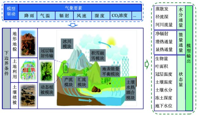
图1 黑河流域上游生态—水文集成模型的多要素耦合注:引自黑河流域生态—水文集成研究重大研究计划总结报告,由杨大文教授提供。 Fig. 1 Multi-features coupling in ecological-hydrological integrated model in the upper Heihe River Basin (From the summary report of the major research project on ecological-hydrological integration research in the Heihe River Basin, provided by Professor Yang Dawen) |
表2 中国知网各种主题中出现“集成”一词的文章数量(篇)Tab. 2 Number of CNKI articles with the keyword "integrations" |
| 地质学 | 气象学 | 自然地理与测绘 | |
|---|---|---|---|
| 全文 | 8350 | - | 20714 |
| 摘要 | 2667 | 1399 | 6499 |
| 关键词 | 41 | 27 | 239 |
注:数据来源于中国知网统计结果,统计时间截至2018年7月;“-”表示该学科排名未能进入前50位,不在统计范围。 |
表3 黑河流域生态—水文—经济集成研究格网数据的制备Tab. 3 Preparation of grid data for ecological-hydrological-economic integration research in the Heihe River Basin |
| 数据类型 | 土壤、植被 | 水热因子 | 气象、气候因子 | 经济 |
|---|---|---|---|---|
| 采集方式 | 采样、观测 | 航空、卫星遥感 | 气候模型 | 统计、调查 |
| 制备方法 | 空间模拟 | 模型反演、地面实验 | 模型模拟 | 空间模拟 |
| 时空特征 | 低分辩率 | 中分辩率 | 高分辩率 | 空间定位 |
| 集成功能 | 区域本底 | 模型参数 | 模型驱动 | 资源平衡 |
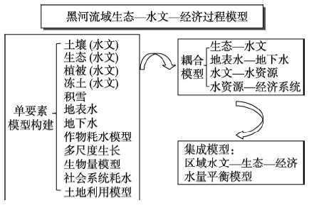
图6 黑河流域系统模型的总体目标及框架注:来源于黑河流域生态—水文集成研究重大研究计划总结报告,由李新研究员提供。 Fig. 6 The goal and framework of the integrated model in the Heihe River Basin(From the summary report of the major research project on ecological-hydrological integration research in the Heihe River Basin, provided by Professor Li Xin) |
衷心感谢北京大学杨大文教授、中国科学院青藏高原研究所李新研究员提供的图片。
| [1] |
[ 樊杰 . “人地关系地域系统”是综合研究地理格局形成与演变规律的理论基石. 地理学报, 2018,73(4):597-607.]
|
| [2] |
[ 浦汉昕 . 中国地理学会在京召开座谈会讨论钱学森教授提倡的地球表层学与数量地理学. 地理学报, 1985,40(3):289-290.]
|
| [3] |
[ 葛全胜, 赵名茶, 郑景云 , 等. 中国陆地表层系统分区: 对黄秉维先生陆地表层系统理论的学习与实践. 地理科学, 2003,23(1):1-6.]
|
| [4] |
[ 吴绍洪, 赵东升, 尹云鹤 , 等. 自然地理学综合研究理论与实践之继承与创新. 地理学报, 2016,71(9):1484-1493.]
|
| [5] |
[ 黄秉维 . 论地球系统科学与可持续发展战略科学基础(I). 地理学报, 1996,51(4):350-354.]
|
| [6] |
2200 Team, 2111 Team, 646 Factory. Requirements for explosive signals. Oil Geophysical Prospecting, 1972(7):68-69.
[ 六四六厂2200队、2111队. 对爆炸讯号的要求. 石油地球物理勘探, 1972(7):68-69.]
|
| [7] |
[ 盛茂, 李根生, 黄中伟 , 等. 页岩气藏流固耦合渗流模型及有限元求解. 岩石力学与工程学报, 2013,32(9):1894-1900.]
|
| [8] |
[ 吕厚远 . 渤海南部晚更新世以来的孢粉组合及古环境分析. 黄渤海海洋, 1989(2):11-26.]
|
| [9] |
[ 宋长青, 程昌秀, 史培军 . 新时代地理复杂性的内涵. 地理学报, 2018,73(7):1189-1198.]
|
| [10] |
[ 程昌秀, 史培军, 宋长青 , 等. 地理大数据为地理复杂性研究提供新机遇. 地理学报, 2018,73(8):1397-1406.]
|
| [11] |
[ 宋长青 . 地理学研究范式的思考. 地理科学进展, 2016,35(1):1-3.]
|
| [12] |
|
| [13] |
|
| [14] |
[ 刘海猛, 方创琳, 李咏红 . 城镇化与生态环境“耦合魔方”的基本概念及框架. 地理学报, 2019,74(8):1489-1507.]
|
| [15] |
|
| [16] |
[ 宋长青, 吕厚远, 孙湘君 . 中国北方花粉—气候因子转换函数建立及应用. 科学通报, 1997,42(20):2182-2185.]
|
| [17] |
[ 刘嘉麒, 吕厚远,
|
| [18] |
[ 程国栋, 肖洪浪, 傅伯杰 , 等. 黑河流域生态—水文过程集成研究进展. 地球科学进展, 2014,29(4):431-437.]
|
| [19] |
|
| [20] |
[ 李新, 晋锐, 刘绍民 , 等. 黑河遥感试验中尺度上推研究的进展与前瞻. 遥感学报, 2016,20(5):921-932.]
|
/
| 〈 |
|
〉 |
