
中国城市规划建设用地标准及气候和地形地貌修订
|
徐勇(1964-), 男, 陕西榆林人, 博士, 研究员, 博士生导师, 主要从事土地利用与人地关系机理模拟、农业与乡村发展、资源环境承载力评价等研究工作。E-mail: xuy@igsnrr.ac.cn |
收稿日期: 2018-06-20
要求修回日期: 2019-12-27
网络出版日期: 2020-03-25
基金资助
第二次青藏高原综合科学考察研究项目(2019QZKK0406)
版权
Urban planning construction land standard and its revision of climate and topography in China
Received date: 2018-06-20
Request revised date: 2019-12-27
Online published: 2020-03-25
Supported by
The Second Tibetan Plateau Scientific Expedition and Research Program(2019QZKK0406)
Copyright
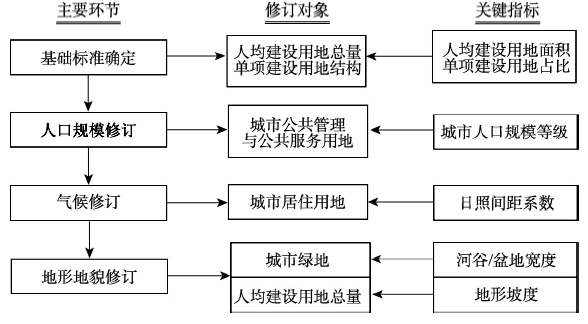
城市规划建设用地标准是科学配置城市各类建设用地的技术规范和编制、修订城市总体规划的基础。针对中国现行城市规划建设用地标准存在的用地指标控制阈值高低差距较大、气候修订缺乏地域分异和地形地貌因素缺失等问题,本文按照“总量—结构”控制的建标思路,提出了标准建立、修订的分步式流程框架和定量测算方法,通过条件设定建立了普适性的建设用地基础标准,进而选择城市人口规模、日照间距系数、河谷地(山间盆地)宽度、地形坡度等关键指标,定量分析了各指标与基础标准之间的关系,形成与基础标准配套的气候和地形地貌修订标准。主要研究结果包括:确定了设定条件下适用于全国不同地区的由人均建设用地面积和人均单项用地类型结构控制的建设用地基础标准;按城市人口规模等级对基础标准进行了量化修订;定量测算了人均居住用地面积随日照间距系数变化的情况,提出了按纬度方向变化的人均建设用地气候修订标准;阐释了河谷地(山间盆地)宽度变化与公园绿地的配置,量化分析了地形坡度与人均建设用地面积变化的关系,建立了针对山地、丘陵地区城市规划建设用地的地形地貌修订标准。
徐勇 , 赵燊 , 樊杰 . 中国城市规划建设用地标准及气候和地形地貌修订[J]. 地理学报, 2020 , 75(1) : 194 -208 . DOI: 10.11821/dlxb202001014
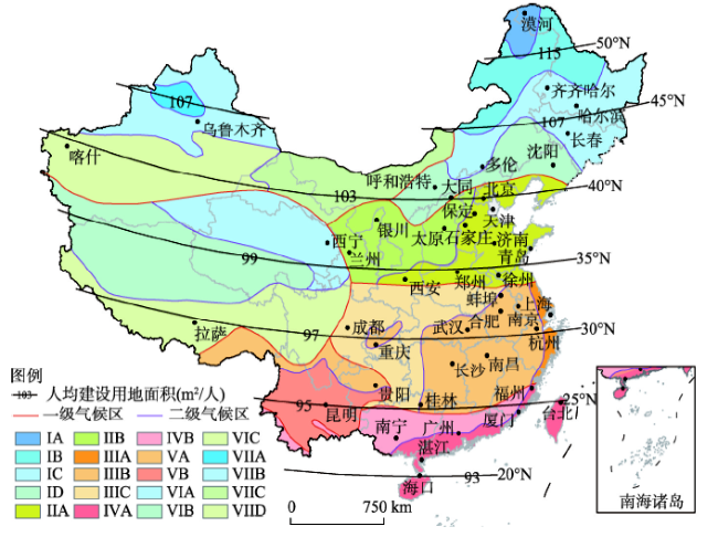
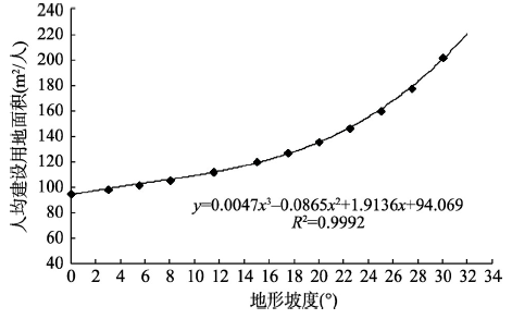
Urban planning construction land standard is the technical specification for allocating various types of urban construction land scientifically, and is the basis for drawing up and revising the overall urban planning as well. In view of China's current urban planning construction land standard, there are many problems such as the big gap of land use control threshold, the lack of regional differences in climate revision, and ignorance of the topographical and geomorphological factors. To solve these problems, this paper proposed a step-by-step process framework and quantitative calculation method for the establishment and revision of standards in accordance with the principle of "total-structure" control. Through the setting of conditions, a universal basic standard for construction land was established. Then quantitative analysis was made for the relations between each index and the basic standard with the selected key indicators such as urban population size, sunshine spacing coefficient, valley area (intermountain basin) width and terrain slope. Finally we formed a revision standard for climate, topography and geomorphology which is matched with the basic standard. The main results are as follows: (1) The per capita construction land area of 95 m 2/person can be used as the total indicator for the basic standard of urban planning in China. The percentage of corresponding per capita for each type of construction land is 32.5% for residential land, 7.42% for public administration and public service land, 22.5% for industrial land, 17.5% for transport facilities, 12.5% of green land, and 7.58% of other types of land. The results of revision value of urban population scale shows that the impact of population size difference on the per capita construction land is relatively weak. (2) The climate revision results of per capita residential land and per capita construction land in major cities show that the climate revision value varies greatly between northern and southern China. The climate revision value of the per capita area of construction land varies by latitude as follows: the figure for 20° north latitude is 93 m 2/person; the figure for 30° north latitude is 97 m 2/person; the figure for 40° north latitude is 103 m 2/person; and the figure for 50° north latitude is 115 m 2/person. The basic standard value of 95 m 2/person is roughly distributed along the Xiamen - Guilin - Kunming line. (3) The cities located in mountainous areas, hilly valleys or intermontane basins can reduce the allocation of community parks and comprehensive parks when the average width of river valley or intermontane basin is less than 2 km. When the average width of the valley or intermontane basins is between 2 km and 4 km, the allocation of the comprehensive parks can be reduced. The revised results of per capita land for construction use on slopes indicate that the terrain slope has a great impact on the revised value of per capita construction land. The revised value at 3° is 3.68% higher than the baseline value, and the increases of 8°, 15° and 25° are 11.25%, 26.49% and 68.47%, respectively.
表1 城市规划基础标准人均单项建设用地构成Tab. 1 The structure of per capita single item construction land of basic standards for urban planning |
| 用地类型 | 基础标准 | 现行标准 | |||
|---|---|---|---|---|---|
| 用地比例(%) | 人均面积(m2/人) | 用地占比区间(%) | 人均面积控制值(m2/人) | ||
| 居住用地 | 32.50 | 30.88 | 25~40 | 23~38 | |
| 公共管理与公共服务用地 | 7.42 | 7.05 | 5~8 | ≥ 5.5 | |
| 工业用地 | 22.50 | 21.38 | 15~30 | ≥ 18 | |
| 交通设施用地 | 17.50 | 16.63 | 10~25 | ≥ 12 | |
| 绿地 | 12.50 | 11.88 | 10~15 | ≥ 10 | |
| 其他用地 | 7.58 | 7.20 | - | - | |
| 合计 | 100.00 | 95.00 | - | - | |
注:其他用地包括商业服务业设施用地、物流仓储用地、公用设施用地等。 |
表2 城市规划建设用地人口规模修订标准Tab. 2 Revision standard of population scale for construction land in urban planning |
| 指标项 | 小城市 | 中等城市 | 大城市Ⅰ | 大城市Ⅱ | 大城市Ⅲ |
|---|---|---|---|---|---|
| 人均公共管理与公共服务用地面积现行标准规定的取值范围(m2/人) | 5.5~7.6 | 5.8~8.1 | 5.9~8.2 | 6.3~8.8 | 6.8~9.2 |
| 人均公共管理与公共服务用地面积(m2/人) | 6.55 | 6.95 | 7.05 | 7.55 | 8.00 |
| 人均建设用地面积(m2/人) | 94.50 | 94.90 | 95.00 | 95.50 | 95.95 |
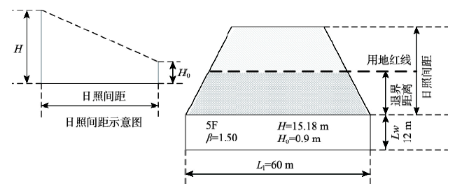
表3 中国主要城市人均居住用地和人均建设用地气候修订情况Tab. 3 Climate revision of per capita residence land and per capita construction land in major cities of China |
| 城市 | 经度(°E) | 纬度(°N) | 日照间距系数 | 日照间距 (m) | 人均居住用地面积调整量(m2) | 人均居住用地面积(m2) | 人均建设用地面积总量(m2) |
|---|---|---|---|---|---|---|---|
| 漠河 | 122°32′20″ | 52°58′21″ | 3.21 | 45.84 | 25.46 | 56.34 | 120.46 |
| 齐齐哈尔 | 123°56′15″ | 47°20′34″ | 2.32 | 33.13 | 15.21 | 46.09 | 110.21 |
| 哈尔滨 | 126°40′10″ | 45°45′35″ | 2.15 | 30.70 | 13.25 | 44.13 | 108.25 |
| 长春 | 125°19′47″ | 43°51′36″ | 1.97 | 28.13 | 11.17 | 42.05 | 106.17 |
| 乌鲁木齐 | 87°37′2″ | 43°49′30″ | 1.96 | 27.99 | 11.06 | 41.94 | 106.06 |
| 多伦 | 116°29′8″ | 42°12′13″ | 1.83 | 26.13 | 9.56 | 40.44 | 104.56 |
| 沈阳 | 123°25′52″ | 41°48′22″ | 1.80 | 25.70 | 9.22 | 40.10 | 104.22 |
| 呼和浩特 | 111°44′49″ | 40°50′37″ | 1.73 | 24.70 | 8.41 | 39.29 | 103.41 |
| 大同 | 113°18′3″ | 40°4′41″ | 1.67 | 23.85 | 7.72 | 38.60 | 102.72 |
| 北京 | 116°23′32″ | 39°54′30″ | 1.67 | 23.85 | 7.72 | 38.60 | 102.72 |
| 喀什 | 75°59′24″ | 39°28′13″ | 1.61 | 22.99 | 7.03 | 37.91 | 102.03 |
| 天津 | 117°11′60″ | 39°5′51″ | 1.61 | 22.99 | 7.03 | 37.91 | 102.03 |
| 保定 | 115°27′40″ | 38°52′32″ | 1.60 | 22.85 | 6.91 | 37.79 | 101.91 |
| 银川 | 106°13′49″ | 38°29′16″ | 1.58 | 22.56 | 6.68 | 37.56 | 101.68 |
| 石家庄 | 114°30′56″ | 38°2′35″ | 1.55 | 22.13 | 6.34 | 37.22 | 101.34 |
| 太原 | 112°32′54″ | 37°52′16″ | 1.54 | 21.99 | 6.22 | 37.10 | 101.22 |
| 济南 | 117°7′12″ | 36°39′4″ | 1.47 | 20.99 | 5.41 | 36.29 | 100.41 |
| 西宁 | 101°46′40″ | 36°37′5″ | 1.47 | 20.99 | 5.41 | 36.29 | 100.41 |
| 青岛 | 120°22′56″ | 36°4′5″ | 1.44 | 20.56 | 5.07 | 35.95 | 100.07 |
| 兰州 | 103°50′3″ | 36°3′40″ | 1.44 | 20.56 | 5.07 | 35.95 | 100.07 |
| 郑州 | 113°37′35″ | 34°44′51″ | 1.36 | 19.42 | 4.15 | 35.03 | 99.15 |
| 徐州 | 117°16′59″ | 34°20′21″ | 1.35 | 19.28 | 4.03 | 34.91 | 99.03 |
| 西安 | 108°56′56″ | 34°15′59″ | 1.35 | 19.28 | 4.03 | 34.91 | 99.03 |
| 蚌埠 | 117°21′23″ | 32°55′14″ | 1.28 | 18.28 | 3.23 | 34.11 | 98.23 |
| 南京 | 118°47′50″ | 32°3′36″ | 1.24 | 17.71 | 2.76 | 33.64 | 97.76 |
| 合肥 | 117°14′10″ | 31°49′24″ | 1.23 | 17.56 | 2.65 | 33.53 | 97.65 |
| 上海 | 121°28′23″ | 31°13′54″ | 1.21 | 17.28 | 2.42 | 33.30 | 97.42 |
| 成都 | 104°4′18″ | 30°39′27″ | 1.18 | 16.85 | 2.07 | 32.95 | 97.07 |
| 武汉 | 114°18′19″ | 30°35′40″ | 1.18 | 16.85 | 2.07 | 32.95 | 97.07 |
| 杭州 | 120°10′41″ | 30°18′16″ | 1.17 | 16.71 | 1.96 | 32.84 | 96.96 |
| 拉萨 | 91°10′21″ | 29°39′11″ | 1.15 | 16.42 | 1.73 | 32.61 | 96.73 |
| 重庆 | 106°33′3″ | 29°33′42″ | 1.14 | 16.28 | 1.61 | 32.49 | 96.61 |
| 南昌 | 115°50′47″ | 28°41′11″ | 1.11 | 15.85 | 1.27 | 32.15 | 96.27 |
| 长沙 | 112°56′18″ | 28°13′43″ | 1.09 | 15.57 | 1.04 | 31.92 | 96.04 |
| 贵阳 | 106°38′56″ | 26°37′4″ | 1.03 | 14.71 | 0.35 | 31.23 | 95.35 |
| 福州 | 119°17′48″ | 26°4′28″ | 1.01 | 14.42 | 0.12 | 31.00 | 95.12 |
| 桂林 | 110°17′24″ | 25°16′27″ | 0.99 | 14.14 | -0.12 | 30.76 | 94.88 |
| 昆明 | 102°42′32″ | 25°1′53″ | 0.98 | 13.99 | -0.23 | 30.65 | 94.77 |
| 厦门 | 118°5′23″ | 24°28′47″ | 0.96 | 13.71 | -0.46 | 30.42 | 94.54 |
| 广州 | 113°15′51″ | 23°7′45″ | 0.92 | 13.14 | -0.92 | 29.96 | 94.08 |
| 南宁 | 108°22′2″ | 22°49′1″ | 0.91 | 12.99 | -1.04 | 29.84 | 93.96 |
| 湛江 | 110°21′35″ | 21°16′17″ | 0.86 | 12.28 | -1.61 | 29.27 | 93.39 |
| 海口 | 110°11′52″ | 20°2′38″ | 0.83 | 11.85 | -1.96 | 28.92 | 93.04 |
表4 河谷地或山间盆地平均宽度与城市规划公园绿地配置情况Tab. 4 The average width of the valley or intermontane basin and the allocation of urban park green space |
| 河谷地或山间盆地平均宽度(km) | 核减公园绿地类型 |
|---|---|
| ≤ 2 | 社区公园、综合公园 |
| 2~4 | 综合公园 |
| ≥ 4 | - |
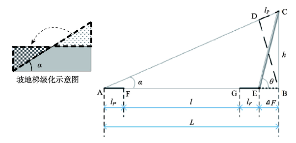
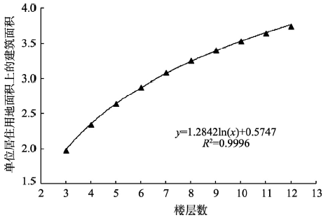
图6 人均建设用地修订值随地形坡度变化Fig. 6 Change of per capita revised value of construction land with topographic slope |
表5 不同地形坡度对应的人均建设用地修订标准Tab. 5 Revision standards of per capita construction land with different terrain slope grades |
| 地形坡度(°) | ω | SL (m2/人) | 增幅(%) |
|---|---|---|---|
| 0 | 1.00 | 95.00 | 0.00 |
| 3 | 1.04 | 98.49 | 3.68 |
| 5.5 | 1.07 | 101.84 | 7.20 |
| 8 | 1.11 | 105.68 | 11.25 |
| 11.5 | 1.18 | 112.13 | 18.03 |
| 15 | 1.26 | 120.16 | 26.49 |
| 17.5 | 1.34 | 127.25 | 33.95 |
| 20 | 1.43 | 135.85 | 43.00 |
| 22.5 | 1.54 | 146.50 | 54.21 |
| 25 | 1.68 | 160.04 | 68.47 |
| [1] |
Ministry of Housing and Urban-Rural Development of the People's Republic of China. Urban Land Classification and Planning and Construction Land Standards (GB 50137—2011).
[ 中华人民共和国住房和城乡建设部. 城市用地分类与规划建设用地标准(GB 50137—2011).]
|
| [2] |
Ministry of Natural Resources of the People's Republic of China. Current Land Use Classification (GB/T 21010—2017).
[ 中华人民共和国自然资源部. 土地利用现状分类 (GB/T 21010—2017).]
|
| [3] |
[ 陆大道, 樊杰 . 2050: 中国的区域发展. 北京: 科学出版社, 2009: 2-7.]
|
| [4] |
|
| [5] |
[ 曲福田, 陈江龙, 陈会广 . 经济发展与中国土地非农化. 北京: 高等教育出版社, 2007: 1-23.]
|
| [6] |
|
| [7] |
[ 蔡运龙, 傅泽强, 戴尔阜 . 区域最小人均耕地面积与耕地资源调控. 地理学报, 2002,57(2):127-134.]
|
| [8] |
[ 谈明洪, 李秀斌, 吕昌河 . 20世纪90年代中国大中城市建设用地扩张及其对耕地的占用. 中国科学D辑: 地球科学, 2004,34(12):1157-1165.]
|
| [9] |
[ 乔陆印, 周伟, 曹银贵 , 等. 城市土地集约利用评价指标体系研究. 生态经济, 2010(6):31-34.]
|
| [10] |
[ 李闽, 姜海 . 建设用地集约利用的理论与政策研究. 中国土地科学, 2008,22(2):55-61.]
|
| [11] |
[ 林坚, 张沛, 刘诗毅 . 论建设用地节约集约利用评价的技术体系与思路. 中国土地科学, 2009,23(4):4-10.]
|
| [12] |
[ 周克昊, 谭荣辉, 刘艳芳 , 等. 基于人均建设用地标准的区域土地利用节地潜力评估. 农业工程学报, 2012,28(19):222-231.]
|
| [13] |
[ 韩丹, 冯长春, 古维迎 . 我国农村居民点土地节约集约利用影响因素及区域差异研究. 中国农业资源与区划, 2010,31(5):29-35.]
|
| [14] |
[ 吴郁玲, 曲福田 . 中国城市土地集约利用的影响机理理论与实证研究. 资源科学, 2007,29(6):106-113.]
|
| [15] |
[ 孙强, 蔡运龙 . 日本耕地保护与土地管理的历史经验及其对中国的启示. 北京大学学报(自然科学版), 2008,44(2):249-256.]
|
| [16] |
[ 刘忠庆, 宋宪明, 王西明 , 等. 建设用地指标置换的问题与对策. 中国土地, 2005(4):25-26.]
|
| [17] |
[ 戴均良, 高晓路, 杜守帅 . 城镇化进程中的空间扩张和土地利用控制. 地理研究, 2010,29(10):1823-1832.]
|
| [18] |
Central Committee of the Communist Party of China and the State Council. Overall Plan of Ecological Civilization System Reform. Beijing: Xinhua News Agency, 2015.
[ 中共中央国务院. 生态文明体制改革总体方案. 北京: 新华社, 2015.]
|
| [19] |
Central Committee of the Communist Party of China and the State Council. Provincial Space Planning Pilot Program. Beijing: Xinhua News Agency, 2016.
[ 中共中央国务院. 省级空间规划试点方案. 北京: 新华社, 2016.]
|
| [20] |
Ministry of Housing and Urban-Rural Development of the People's Republic of China. Urban Land Classification and Planning and Construction Land Standards (GBJ 137—90).
[ 中华人民共和国住房和城乡建设部. 城市用地分类与规划建设用地标准 (GBJ 137—90).]
|
| [21] |
[ 蒋大卫 . 城市建设用地标准要量体裁衣. 城市规划, 1996,20(5):58.]
|
| [22] |
[ 涂志华, 王兴平, 成翠萍 . 城乡建设用地标准优化和改进探讨: 基于规划编制和管理的视角. 城市发展研究, 2013,20(9):58-65.]
|
| [23] |
[ 汪军, 赵民 . 规划建设用地标准的影响因素及多元控制. 现代城市研究, 2011(9):30-38.]
|
| [24] |
[ 冒亚龙 . 回应气候的山地城镇与建筑设计. 山地学报, 2009,27(5):605-611.]
|
| [25] |
Ministry of Housing and Urban-Rural Development of the People's Republic of China. Code for Design of Civil Buildings (GB 50352—2005).
[ 中华人民共和国住房和城乡建设部. 民用建筑设计通则(GB 50352—2005).]
|
| [26] |
[ 谢守穆 . 《建筑气候区划标准》GB0178—93介绍. 建筑科学, 1994(4):57-61.]
|
| [27] |
[ 赵文凯 . 日照标准. 城市规划, 2002,26(12):90-91.]
|
| [28] |
[ 田峰, 宋小冬 . 中日住宅日照规定体系比较. 城市规划学刊, 2005(1):75-78.]
|
| [29] |
[ 牛叔文, 李景满, 李升红 , 等. 基于地形复杂度的建设用地适宜性评价: 以甘肃省天水市为例. 资源科学, 2014,36(10):2092-2102.]
|
| [30] |
[ 封志明, 唐焰, 杨艳昭 , 等. 中国地形起伏度及其与人口分布的相关性. 地理学报, 2007,62(10):1073-1082.]
|
| [31] |
[ 喻红, 曾辉, 江子瀛 . 快速城市化地区景观组分在地形梯度上的分布特征研究. 地理科学, 2000,21(1):64-69.]
|
| [32] |
[ 陈燕飞, 杜鹏飞, 郑筱津 , 等. 基于GIS的南宁市建设用地生态适宜性评价. 清华大学学报(自然科学版), 2006,46(6):801-804.]
|
| [33] |
[ 黄光宇 . 山地城市学原理. 北京: 中国建筑工业出版社, 2006: 1-5.]
|
| [34] |
[ 李和平, 肖竞 . 山地城市“城—山”营建关系的多维度分析. 城市规划, 2013,20(8):40-46.]
|
| [35] |
|
| [36] |
|
| [37] |
Ministry of Housing and Urban-Rural Development of the People's Republic of China. Urban Public Facilities Planning Code (GB50442—2008).
[ 中华人民共和国住房和城乡建设部. 城市公共设施规划规范(GB50442—2008).]
|
| [38] |
Ministry of Housing and Urban-Rural Development of the People's Republic of China. Standard of Climatic Regionalization for Architecture (GB50178—93).
[ 中华人民共和国住房和城乡建设部. 建筑气候区划标准(GB50178—93).]
|
| [39] |
Ministry of Housing and Urban-Rural Development of the People's Republic of China. Code for Planning and Design of Urban Residential District (GB 50180—93, Revised Edition of 2016).
[ 中华人民共和国住房和城乡建设部. 城市居住区规划设计规范(GB 50180—93, 2016年版).]
|
| [40] |
Ministry of Housing and Urban-Rural Development of the People's Republic of China. Standard for Classification of Urban green space (CJJ/T 85—2002).
[ 中华人民共和国住房和城乡建设部. 城市绿地分类标准(CJJ/T 85—2002).]
|
| [41] |
Ministry of Housing and Urban-Rural Development of the People's Republic of China. Standard for Classification of Urban Green Space (CJJ/T 85—2017).
[ 中华人民共和国住房和城乡建设部. 城市绿地分类标准(CJJ/T 85—2017).]
|
| [42] |
Ministry of Housing and Urban-Rural Development of the People's Republic of China. Technical Code for Building Slope Engineering (GB 50330—2013).
[ 中华人民共和国住房和城乡建设部. 建筑边坡工程技术规范(GB 50330—2013).]
|
| [43] |
Ministry of Housing and Urban-Rural Development of the People's Republic of China. Code for Design of Urban Road Engineering (CJJ37—2012, Revised edition of 2016).
[ 中华人民共和国住房和城乡建设部. 城市道路工程设计规范(CJJ37—2012, 2016年版).]
|
| [44] |
[ 江海燕, 周春山, 肖荣波 . 广州公园绿地的空间差异及社会公平研究. 城市规划, 2010,34(4):43-48.]
|
/
| 〈 |
|
〉 |