Strategic Priority Research Program of the Chinese Academy of Sciences(XDA20100102) National Natural Science Foundation of China(42077415) The Second Tibetan Plateau Scientific Expedition and Research(2019QZKK0202) The 111 Project(BP0618001)
人类活动与全新世环境变化的耦合过程与机理已成为地球科学领域的研究热点。湖泊沉积物储存了丰富的环境信息,已成为反演过去气候变化的良好材料。目前古环境代用指标指示人类活动的研究多通过单一湖泊进行讨论,缺乏一定的整体区域研究,且通过古环境代用指标辨识该区域人类活动的研究相对较少,指示人类活动的古环境代用指标具有不确定性。本文分析了祁连山周边内流河流域14个终端湖泊的岩性、年代和古环境代用指标数据,重建了该区域全新世以来的气候变化,探索了全新世以来气候变化与人类活动的耦合关系。初步结果如下:全新世以来祁连山及周边地区终端湖泊中有机质多为水生和陆生植物混合来源;祁连山地区早中全新世气候温暖湿润,晚全新世以来气候干旱化明显;古环境代用指标变化与沉积相变化密切相关,不同沉积相对应的代用指标指示意义差异较大,2.0 cal ka BP以来湖泊沉积相的变化开始受到人类活动影响,距今200 a左右开始,人类活动对区域环境变化起主导作用。
关键词:祁连山;
内流区;
湖泊沉积相;
古环境代用指标;
人类活动
Abstract
The process and mechanism of coupling between human activities and Holocene environmental change has become a research hotspot in the field of earth sciences. Lake sediments store rich environmental information, which can help to reconstruct past climate changes. Up to now, most of the studies on the palaeoenvironmental proxies indicating human activities have focused on single lakes, and there is a lack of comprehensive studies at a regional scale. Furthermore, relatively few studies focus on the identification of regional human activities through the paleoenvironmental proxies, partly due to the uncertainty of their indicative significance. In this paper, we analyzed the lithology, ages, and palaeoenvironmental proxy data from 14 closed-basin lakes around the Qilian Mountains, reconstructed the Holocene climate change, and explored the coupling relationship between climate change and human activities. The results are as follows: the organic matter in the terminal lakes in the Qilian Mountains and the surroundings is mostly from the mixed sources of aquatic and terrestrial plants; it was warm and humid during the early and middle Holocene around the Qilian Mountains, then it has experienced significant regional aridification since the late Holocene; the changes of sedimentary facies are consistent with proxies, which have different significance in various sediments. The changes of lake sedimentary facies have been affected by human activities since 2.0 cal ka BP, and human activities have dominated the regional environmental changes since 1800 AD.
Keywords:Qilian Mountains;
closed basins;
lake sediments;
paleoenvironmental proxies;
human activities
GAO Mingjun, LI Yu, ZHANG Zhansen, ZHOU Xueru, LI Haiye, DUAN Junjie, XUE Yaxin. Study on lake sediments and human activities in closed basins around the Qilian Mountains. Acta Geographica Sinica, 2023, 78(5): 1192-1212 doi:10.11821/dlxb202305009
Fig. 3
Changes in lithology and paleoenvironmental proxies of terminal lake sediments in the Qilian Mountains and the surroundings
猪野泽剖面沉积相变化较为明显,TOC、C/N和δ13Corg随沉积相变化而改变,说明沉积物中有机地球化学指标受沉积相控制[26]。三角城古湖泊剖面460 cm以下主要为风成沉积层,含较粗的碎屑物质,TOC含量较低(< 2%),δ13Corg偏轻,多分布在-30‰~25‰;460 cm以上沉积层以湖相沉积为主,TOC含量明显增大,δ13Corg偏重,约为-20‰~10‰,表明不同的沉积相中代用指标的变化存在差异[28]。居延海岩芯中粉砂层 TOC含量较高,风成沉积层TOC含量较低。根据磁学性质划分的层位对应到了沉积相发生砂层和粘土层相互改变的时期,因为磁性矿物与粒径组分变化情况相一致,沉积物中粒径>30μm的磁性矿物多于粒径< 2 μm的磁性矿物。因此,沉积相的改变会导致沉积物磁性颗粒数变化,改变磁性参数[34]。花海剖面岩性、TOC、C/N、碳酸盐和粒度的演化过程表明,800 cm以下芒硝层出现和TOC含量降低象征着干旱环境;800 cm以上(8.8—10.4 cal ka BP)湖相沉积出现对应古环境代用指标指示由干旱转为湿润的环境;5.5 cal ka BP以后间断沉积相的出现标志着该区域全新世中晚期向干旱环境过渡,代用指标对应发生变化[31]。依据沉积地层变化,盐池剖面被划分成6个阶段,该剖面的岩性与粒度、矿物组成、碳酸盐含量、C/N等指标均有良好的对应关系,很好的还原了全新世以来的环境演化过程[29]。伊塘湖剖面在936~1352 cm沼泽相沉积中TOC含量波动明显,δ13Corg偏正,表明此阶段湖泊生产力提高,气候趋于暖湿,与岩性体现的湖相沉积相一致;300~936 cm岩性变为粘土和粉砂粘土,TOC含量降低,δ13Corg偏正,表明水生植被为湖泊有机质的主要输入来源,此时处于全新世中期气候适宜期;300 cm以上为粘质粉土,TOC和C/N增大,但因邻近现代,所受影响因素较多[35]。尕海岩芯共分为4个阶段:3073~3483 cm(1136—1271 cal a BP)以砂层为主,多为粉细砂和中砂,具有风成沉积特征;2280~3073 cm(8370—1136 cal a BP)以砂层、粘土层为主,代用指标变化较大,波动明显。尽管岩性没有发生太大变化,但根据岩层中碳酸盐含量、文石和石膏的变化情况可以判断出湖泊很有可能从硫酸盐沉积逆向演化成了碳酸盐沉积,δ13Ccarb和δ18O的高值指示当时温度较高,蒸发作用较强;707~2280 cm(3200—8370 cal a BP)以粘土为主,气候较稳定,指标变化相对一致;0~707 cm(0—3.2 cal ka BP)以细砂和粉砂为主,各指标波动幅度变大,气候变化显著[43]。茶卡盐湖剖面划分为 5个阶段:693~900 cm(11.4—17.2 cal ka BP)为层状粘土粉砂层,TOC和 TN含量较低,表明初级生产力较低,温度可能达到低值;582~693 cm(6.0—11.4 cal ka BP)由硫酸盐矿物和暗色粘质淤泥组成,TOC和TN含量突增,与当时温暖湿润的气候有关,石膏的出现表示湖泊从淡水到高盐度环境的改变;567~582 cm(5.3—6.0 cal ka BP)TOC和 TN含量较高,土壤湿润,但盐度仍较高;270~567 cm(1.7—5.3 cal ka BP)湖泊盐度快速升高,高盐度环境导致湖泊初级生产力低下,TOC和TN含量较低,分别为0.2%和0.03%;0~270 cm(0—1.7 cal ka BP)岩盐含量急速增加,TOC和TN含量下降至0.06%和0.02%,湖泊盐度再次增加[39]。根据沉积相、地球化学和矿物等数据,冬给错纳岩芯被划分成5个岩性单元,反映了湖泊系统发育的不同阶段。全新世沉积环境发生明显变化,沉积成分改变影响古环境代用指标的变化情况[42]。更尕海剖面主要以粘质粉土、粉砂和粉砂粘土相间存在,TOC、TN和δ13Corg指标波动较为复杂,随沉积相变化表现不明显,可能与沉积相频繁变换有关[41]。哈拉湖剖面上部57 cm呈现相对柔软的褐色物质,含水量较大;57~200 cm沉积物逐渐致密,形成层压较好的灰色和深色层,同时,黑色层出现表明有大量有机物质沉积,与LOI含量的高值相对应;200~270 cm以褐色沉积物为主。一般情况下沉积物红度较高,对应上部沉积物中碳酸盐含量较高[40]。
Fig. 4
Changes in paleoenvironmental proxies from typical records since the Holocene
孢粉常用于还原古环境的植被组成,从而反映过去环境变化[70]。青海湖江西沟2号遗迹文化层的孢粉研究发现,菊科、蔷薇科含量在4.0 cal ka BP以来大幅增加,2.0 cal ka BP以来仍持续增多,这些类型多是伴人杂草植物,与人类活动有关,表明晚全新世以来人类活动强度逐渐增强(图4i)[71-72]。沙尘暴记录作为界定人为影响的重要标志,重建的北方沙尘暴数据表明2.0—11.0 cal ka BP期间沙尘暴主要受东亚夏季风和植被覆盖控制,2.0 cal ka BP以来,随着人类对地表覆被干扰的持续加剧,人类活动开始在几十年到百年的时间尺度上主导亚洲沙尘暴(图4h)。猪野泽沉积记录指出TOC含量在1.5 cal ka BP时开始大幅减少可能与1.5 cal ka BP以来该区域人口数量明显增加,人类乱砍滥伐森林、过度放牧等造成研究区植被数量迅速减少有关(图4f)。猪野泽沉积物的中值粒径在1.5 cal ka BP以来波动幅度较大,粒径显著增大(图4g)。人类对地表的改造作用也会造成沉积物粒径增大,该结果在盐池、花海、兴凯湖和青海湖等的粒度研究中已得到证实[69,73 -74],结合猪野泽TOC的大幅减少,因此猪野泽沉积物中值粒径增大可能与人类活动对植被的破坏造成的水土流失加强有关。虽然不同地区粒径明显增大的时间略有不同,但整体而言,在2.0 cal ka BP以来粒度受人类活动影响的程度逐渐增大。
CaCO3含量通常被用来反映流域尺度的水分有效性。盐池剖面中晚全新世随着湖泊退缩CaCO3含量逐渐降低,但是在1.0 cal ka BP左右出现了波动上升的趋势(图4e)。气温在千年尺度稳定下降,降水也未出现大幅波动,因此气候并非其变化的主要因素。在该时期,西夏完成了对河西走廊完成了统一,并进行了一系列经济开发措施。由于西夏是少数民族政权,重牧轻农的开发政策使得流域土地覆被改变,导致风化增强,输入物质增加,可能导致了该时期CaCO3含量明显增高[75]。
湖泊MS是记录陆地环境变化的重要信息来源,可被置于与人类活动相关的历史背景中进行讨论[76]。2.5—1.2 cal ka BP期间MS急剧增加后又急剧减少表明了沙漠的迅速扩张和迅速退缩,CaCO3含量与之对应,表明该地区可能发生了较为剧烈的气候波动(图4d);0.2 cal ka BP以来MS和CaCO3均出现增加趋势,表明气候趋于冷干,该时期内人口数量增多,活动强度增大,导致植被覆盖减少,水土流失严重,加快了湖泊萎缩速度,使得进入湖泊的外源物质明显增加,随着湖泊干涸,可能整个流域都受到碎屑磁性矿物的再沉积作用,间接对沉积物的MS造成影响[77]。
全新世期间2.8—4.3 cal ka BP,5.0—6.5 cal ka BP和7.0—8.5 cal ka BP为中国人口增多的时期,该时段内温和的气候刺激了史前人口增长和文化进步[78]。研究区人类遗址的变化也显示出4.0—6.0 cal ka BP和3.0 cal ka BP以来人类遗址数量明显增加,与之前的研究一致。图4j显示祁连山及周边地区人口遗址数量在2.0 cal ka BP左右开始急剧增加,此时处于两汉时期,气候温暖湿润,大量人口迁入内地,遗址数量明显增多[79];在1.0 cal ka BP左右人口遗址数量也相对增加,此时正处于宋元时期,对应中世纪暖期(MWP),较适宜的气候和农耕经济的快速发展促使人类开始定居于此,遗址数量逐渐增长[80]。
图4显示古环境代用指标基本在2.0 cal ka BP左右开始发生较为剧烈的波动,与2.0 cal ka BP以来气候的一致性较差,可能是人类活动造成了地表作用形态改变,导致湖泊沉积物粒径增大,植被覆盖度的降低则使得有机质含量降低等。因此,人类活动强度增大到一定程度时可以改变代用指标在自然状态下的变化趋势,影响其指示意义。此外,本文收集了一些关于利用沉积物古环境代用指标指示人类活动的研究,结果表明人类活动对环境产生重要作用的时期多集中在2.0—3.0 cal ka BP(表3),与上述发现代用指标异常波动的时期较为接近。
Tab. 3
表3
表3沉积物古环境代用指标指示的人类活动时期
Tab. 3 The period of human activities indicated by the paleoenvironmental proxy in the sediments
晚全新世以来祁连山及周边地区整体降水较中全新世较少,尽管在中世纪暖期和小冰期阶段存在不断的冷暖交替时期,但依旧在区域内呈现干旱化趋势。在干旱化的背景下,祁连山及周边地区湖泊面积逐渐退缩。然而从西北地区湖泊的演化过程来看,近2 ka来湖泊干涸和萎缩速度已经远远超过自然时期的速度。研究显示猪野泽晚全新世以来湖泊面积明显缩小,出现泥沼相沉积物,最上面覆盖了现代风成沉积物[26];三角城古湖泊自6.4 cal ka BP以来受气候环境变化和人口活动增加的影响,被分割构成了几个碳酸盐湖和沼泽[84];盐池在4.7 cal ka BP以来湖泊退缩速度加快,最终干涸[29];居延海面积从2.0 cal ka BP的2000 km2,逐渐萎缩到现在的66.3 km2;条湖在唐代中期后变为干涸状态[85]。青海湖、尕海、哈拉湖和更尕海等水位下降,湖泊面积迅速缩小[52],如尕海地区在3.0 cal ka BP以来降水量明显降低,湖泊受到的蒸发作用增大,面积减小,湖水盐度明显增大[38];茶卡盐湖自晚全新世以来湖泊萎缩明显,咸化程度加大[39];青海湖由秦汉时期的6000 km2减少至1970年的4474 km2。以上数据表明了晚全新世以来祁连山及周边地区许多湖泊面积出现明显退缩,退缩速度远远超过了先前的湖泊演化速度,这单单依靠近千年以来的气候变化解释湖泊干涸的速度远远不够。
Fig. 5
The spatiotemporal distribution of archaeological sites in the Qilian Mountains and the surroundings since the Holocene
此外,关于区域环境变化和人类活动信息的要素,如黄土、冰芯,树轮等的相关研究也体现了近2000年以来环境变化与人类活动的耦合关系。在黄土记录中,中世纪暖期(MWP)时期对应中国的宋元时期,气候温暖湿润,旱作农业得到快速发展[87]。黄土高原六盘山北联池中晚全新世沉积记录发现,1.4—5.0 cal ka BP区域环境以自然气候为主,人类活动较少,0.8—1.4 cal ka BP人类活动开始影响湖泊周边环境,在0.8 cal ka BP以来,人类活动成为湖泊环境变化的主要影响因素[88]。中低纬度冰芯与人类活动联系更为密切[89],青藏高原冰芯中的SO42-在1870年之后浓度快速升高[90];慕士塔格冰芯发现Pb浓度在1973年以来大幅增加[91];东绒布冰芯黑炭记录在近百年来明显增多[92],均与近代工业活动增多,人类活动排放增加有关。用于火历史重建的碳屑研究中显示,美国西部火灾频率在MWP向LIA过渡时期发生较多,而LIA较少,冷湿气候会降低火灾发生频率,该结果在加拿大东部的森林研究中已被证实[93]。欧洲树轮火疤分析显示,18世纪火偏多与人类养蜂活动密切相关[94]。不同地区人类活动主要作用于环境的时间说法不一,但大多集中在18—19世纪,人类活动逐渐转变为区域环境变化的主要驱动力。
Fig. 6
Frame diagram of interactions among lake sedimentary facies, paleoenvironmental proxies, human activities, and climate change since the Holocene
IPCC. Summary for policymakers//Masson-Delmotte V P, Zhai A, Pirani S L, et al. Climate Change 2021: The Physical Science Basis. Contribution of Working Group I to the Sixth Assessment Report of the Intergovernmental Panel on Climate Change. Cambridge: Cambridge University Press, 2021.
During the past few years, an increasing number of studies in both China and abroad have highlighted a long-term warming trend during the Holocene. However, this trend challenges the traditional view of a long-term Holocene cooling trend and a "mid-Holocene Megathermal". Comparison of long-term records indicating a rising global sea level, a decreasing area of terrestrial ice-sheets, and increasing radiative forcings of insolation and GHGs (greenhouse gases) leads us to conclude that a long-term Holocene warming trend is more reasonable than the cooling trend. In the original literature documenting a "mid-Holocene Megathermal" and the subsequent late Holocene cooling trend in China, the uncertainties in the supporting evidence are clearly indicated. These uncertainties have been further demonstrated by recent results that the most significant uncertainty arises from the impacts of human activities on sedimentary proxies, especially in the late Holocene when these impacts were greatly intensified. Thus, reconstructions of late Holocene temperature history based on sedimentary proxies are potentially biased by human impacts. Given that the current debate regarding temperature history of the Holocene focuses on the late Holocene, we propose that future emphasis should be placed on the temperature history of the late Holocene. We suggest that more reliable late Holocene temperature records should come from areas and/or sedimentary proxies that are weakly influenced by human activities, which is especially important to studies on the development of Chinese civilization that lasted for over several millennia. Overall, reliable late Holocene temperature records can potentially provide a reliable foundation for improving our understanding of the following themes: (1) the development of Chinese civilization under the background of long-term temperature change; (2) the evolutionary history of "human-land relationship" during the late Holocene; and (3) the climatic and environmental issues associated with global warming.
The lack of a precisely-dated, unequivocal climate proxy from northern China, where precipitation variability is traditionally considered as an East Asian summer monsoon (EASM) indicator, impedes our understanding of the behaviour and dynamics of the EASM. Here we present a well-dated, pollen-based, ~20-yr-resolution quantitative precipitation reconstruction (derived using a transfer function) from an alpine lake in North China, which provides for the first time a direct record of EASM evolution since 14.7 ka (ka = thousands of years before present, where the “present” is defined as the year AD 1950). Our record reveals a gradually intensifying monsoon from 14.7–7.0 ka, a maximum monsoon (30% higher precipitation than present) from ~7.8–5.3 ka and a rapid decline since ~3.3 ka. These insolation-driven EASM trends were punctuated by two millennial-scale weakening events which occurred synchronously to the cold Younger Dryas and at ~9.5–8.5 ka and by two centennial-scale intervals of enhanced (weakened) monsoon during the Medieval Warm Period (Little Ice Age). Our precipitation reconstruction, consistent with temperature changes but quite different from the prevailing view of EASM evolution, points to strong internal feedback processes driving the EASM and may aid our understanding of future monsoon behaviour under ongoing anthropogenic climate change.
LiMingqi, ShaoXuemei, ZhangYong.
Precipitation variation and its linkage with solar activity and large volcanic eruptions during 392 BC-2017 AD in northeastern Qaidam Basin, China
Based on the tree-ring increment cores of Juniperus przewalskii Kom. collected from the Maoniu Mountain in inner Qaidam Basin, the new 2710-year tree-ring width chronology was developed, and the correlation coefficients were calculated between the chronology and meteorological data during the instrumental period of 1957-2017. The results showed that the highest correlation existed between the total precipitation from July of previous year to June of current year and the chronology (r = 0.753, n = 60, p < 0.01). Based on the correlation relationship, total precipitation variation from July of previous year to June of current year was reconstructed from 392 BC to 2017 AD. The reconstruction explained 64% of the variation in the total precipitation from previous July to current June for the calibration period (1957-2017 AD). The results showed that there were nine wet periods which occurred during 106-75 BC, 6-39 AD, 179-229 AD, 581-646 AD, 823-914 AD, 1026-1095 AD, 1378-1414 AD, 1567-1609 AD and 1985-2017 AD, and seven dry periods occurring during 328-297 BC, 86-151 AD, 694-747 AD, 1168-1199 AD, 1444-1525 AD, 1680-1725 AD and 1792-1860 AD in the past 2409 years. Among these wet and dry periods, 1792-1860 AD was the driest period. Power spectral analysis revealed cyclic fluctuations of the precipitation series on 2~8 years, 40 years, 80 years and 225 years (p < 0.01). In addition, the solar minimum phases were in accord with the dry period in our study area in the past 2409 years, and the results of superposed epoch analysis showed that the precipitation decreased significantly in the following year after large volcanic eruptions observed at low-mid latitudes. The results indicated that solar activity and large volcanic eruptions were factors impacting precipitation variation in our study area.
Numerous studies have focused on environmental changes and lacustrine ecological transitions in the modern industrial era. However, little is known about the processes of ecological transitions during early human disturbances. The current lake ecosystem state is the result of long-term integrated human influences on lakes. In this study, we present multi-proxy evidence of changes in the lacustrine environment, ecosystem, and human activities inferred from a sediment core collected from Beilianchi Lake in the southwestern Chinese Loess Plateau, to document the lacustrine ecological transitions with increasing human disturbances during the past 5000 years. Our data reveal the lacustrine ecosystem was quite stable with unchanging terrestrial versus aquatic sourced organic matter before major human disturbances (4400-1400 BP), although there was a decline in precipitation and a transition from tree-to herb-dominated vegetation. From 1400 to 300 BP, when early humans began to occupy and disturb the catchment, the lake experienced high-magnitude, centennial-to decadal-scale oscillations between aquatic and terrestrial sourced organic contributions. Thereafter, as human activities further increased, the lacustrine ecosystem finally stabilized at a state with terrestrial dominated organic matter. Our results suggest that the lake experienced large-magnitude ecological oscillations during the period of 1400 -300 BP, probably indicating the lake ecosystem retained the capability of recovery from the modest early human disturbances on the catchment. The recovery of the ecosystem to these external disturbances lasted hundreds of years with centennial to decadal scales oscillations. With further increased human influences since 300 BP, the lacustrine ecosystem probably finally shifted to another state largely deviating from its natural (climate-driven) background. (C) 2018 Elsevier Ltd.
HuangX Z, LiuS S, DongG H, et al.
Early human impacts on vegetation on the northeastern Qinghai-Tibetan Plateau during the middle to late Holocene
Progress in Physical Geography, 2017, 41(3): 286-301.
HuZhujun.Ecological changes and driving mechanisms of alpine lakes in the southeastern margin of the Qinghai-Tibet Plateau[D]. Beijing: University of Chinese Academy of Sciences, 2013.
Based on the results of lacustrine environmental proxies from Erhai Lake, Yunnan Province,the lake responses of human activities recorded by lacustrine sediment in the catchment have been discussed. The Erhai Core of 310 cm long was sampled in the center of Erhai Lake with the water depth of 4 6 m. The modern sedimentation rate by 137 Cs test is ≤0 25 mm/a, which is consistent with the average sedimentation rate of the upper 100 cm with radio carbon years of 4 473±40 a BP at the bottom. Because the surface soil are rich in magnetic materials. The environmental proxy of magnetic susceptibility was obviously influenced by the way of land use especially the occurrence of farming agriculture. So the sharp increase of magnetic susceptibility at 100 cm with ca 4 500 a BP means the intensification of human activities especially the occurrence of farming agriculture. The time of the ancient farming occurrence recorded by the lake sediment is older than the archaeological relics with the radio carbon years of ca 3 800 a BP in Baiyang Village near the catchment of Erhai Lake. The surface soil is rich with elements of Fe and Al in the catchment of Erhai Lake. So the changes of chemical elements contents (Fe, Al) had close relationship with surface water soil erosion which controlled by the human activities in the catchment. The huaman relics of Malong in the catchment of Erhai Lake with the age of 34003100aBP which corresponding with the sharp increase of element Fe and Al. The lower content of Fe, Al in the upper 15 cm may be affected by the aquatic vegetation which can absorb some chemical elements including Fe and Al. The variations of pigments indicated the process of lake eutrophication induced by human activities. The first and second peaks of pigments correspond with the time of Malong Relics and the first population summit of Yunnan Province. The obvious increase of pigments was occurred in 1100 AD with the large population migrated to Yunnan. The proxies of lacustrine magnetic susceptibility, chemical elements and pigments are the efficient parameters to demonstrate the human activities in the catchment, which has important significance in the research on archaeology.
Characteristics of agricultural activities and its impact on the environment at Xintala site, Xinjiang, reconstructed from archaeological plant remains
According to the Second Chinese Glacier Inventory (SCGI) that were mostly compiled based on Landsat TM/ETM+images, the Qilian Mountains contained 2684 glaciers covering an area of 1597.81±70.30βkm2 and ice volume of ~84.48βkm3 from 2005 to 2010. While most glaciers are small (85.66% are smaller than 1.0βkm2), some larger ones (12.74%, with each having 1.0 and 5.0βkm2) cover 42.44% of the total glacier area. The Laohugou No.12 Glacier (20.42βkm2) located on the north slope of the Daxue Range is the only one larger than 20 km2 in the Qilian Mountains. The average median altitude of glacier was 4972.7βm a.s.l. and gradually rose from east to west. Glaciers in the Qilian Mountains are mostly distributed in Gansu and Qinghai provinces, which have 1492 glaciers (760.96βkm2) and 1192 glaciers (836.85βkm2), respectively. In 11 watersheds, the Shule River contains most of the glaciers in either area or volume. However, the Heihe River, the second longest interior river in China, has the minimum average area of glacier. Comparison of glaciers from the SCGI and the revised glacier inventory based on topographic maps and aerial photos taken from 1956 to 1983 indicated that all the glaciers in the Qilian Mountains were receding, which is consistent with other mountains and plateaus in western China. In the past half century, the area and volume of glaciers decreased by 420.81βkm2 (-20.88%) and 21.63βkm3 (-20.26%), respectively. The glaciers which are smaller than 1.0βkm2 constituted the main body of glacier number depression and area recession. Due to shrinkage, the glaciers below 4000βm a.s.l. completely disappeared.
Arid and semi-arid ecosystems are increasingly recognized as important carbon storage sites. In these regions, extensive sequestration of dissolved inorganic carbon can occur in the terminal lakes of endorheic basins-basins that do not drain to external bodies of water. However, the global magnitude of this dissolved inorganic carbon sink is uncertain. Here we present isotopic, radiocarbon, and chemical analyses of groundwater, river water, and sediments from the terminal region of the endorheic Shiyang River drainage basin, in arid northwest China. We estimate that 0.13 Pg of dissolved inorganic carbon was stored in the basin during the mid-Holocene. Pollen-based reconstructions of basin-scale productivity suggest that the mid-Holocene dissolved inorganic carbon sink was two orders of magnitude smaller than terrestrial productivity in the basin. We use estimates of dissolved inorganic carbon storage based on sedimentary data from 11 terminal lakes of endorheic basins around the world as the basis for a global extrapolation of the sequestration of dissolved organic carbon in endorheic basins. We estimate that 0.152 Pg of dissolved inorganic carbon is buried per year today, compared to about 0.211 Pg C yr(-1) during the mid-Holocene. We conclude that endorheic basins represent an important carbon sink on the global scale, with a magnitude similar to deep ocean carbon burial.
FuC F, AnZ S, QiangX K, et al.
Origin of the yellow-brown earth sediment on the bottom of Yilangjian core from Lake Qinghai and its environmental implication
The paleoenvironmental significance of organic carbon isotope in lacustrine sediments in the arid China: An example from sanjiaocheng palaeolake in Minqin
Millennial-scale environmental changes in the Asian monsoon margin during the Holocene, implicated by the lake evolution of Huahai Lake in the Hexi Corridor of northwest China
The Holocene environmental change of Juyan Lake in northwestern China was studied through combination of analyzing magnetic parameters of lacustrine core from G36 drilling hole in Juyan Lake, investigating total organic carbon content and grain size and other environmental proxies, and precisely AMS14C dating. Results show that most magnetic carrier minerals appeared in coarse sediments and the main magnetic minerals are contained in coarse multi-domain magnetite particles. The change mechanism of magnetic susceptibility is complicated and there is no simple positive or negative relationship between magnetic susceptibility change and environmental arid-wet change. Analysis of environmental proxies showed that the Holocene environmental changes of Juyan Lake could be divided into four arid-wet alternating periods: arid period in 6 700~4 600 a BP, wet period in 4 600~3 100 a BP, arid period in 3 100~2 500 a BP, and the lake drying up period since 1 800 a BP. In this four periods, two significant wet events and two outstanding arid events are recorded by magnetic parameters.
对居延海G36钻孔进行了系统磁性特征分析,并结合总有机碳含量和粒度等环境代用指标,在精确测年的基础上,探讨了居延海地区全新世时期以来的环境变化。结果显示,居延海岩芯磁性矿物主要存在于粗颗粒的沉积物中,载磁矿物为颗粒较粗的多畴磁铁矿;磁化率变化机制比较复杂,与干湿环境变化没有简单正(反)关系。根据G36沉积物环境代用指标的变化,大致可以将其分为4个干湿交替时期:6 700~4 600 a BP干旱时期,4 600~3 100 a BP湿润时期,3 100~2 500 a BP干旱时期以及1 800 a BP以来湖泊干涸。在这4个时期中,磁学参数记录了两次显著湿润事件和两次显著干旱事件。
ZhaoLiyuan, LuHuayu, ZhangEnlou, et al.
Lake-level and paleoenvironment variations in Yitang Lake (northwestern China) during the past 23 ka revealed by stable carbon isotopic composition of organic matter of lacustrine sediments
LiuSong.Lacustrine sediment variations based on multi-proxy records and potential implications from Hala Lake, NW China[D]. Nanjing: Nanjing University, 2014.
GuoXiaoyan.Holocene climate change documented by lake sediments from Lake Gahai in the monsoonal margin region, Northwest China[D]. Lanzhou: Lanzhou University, 2012.
Late Quaternary water depth changes in Hala Lake, northeastern Tibetan Plateau, derived from ostracod assemblages and sediment properties in multiple sediment records
HuYu.Vegetation evolution and climatic change documented by Hala Lake sediments in the northeasten Qinghai-Tibetan Plateau since the Last Glacial Maximum[D]. Lanzhou: Lanzhou University, 2016.
Quantitative reconstruction of precipitation changes on the NE Tibetan Plateau since the Last Glacial Maximum: Extending the concept of pollen source area to pollen-based climate reconstructions from large lakes
. Pollen records from large lakes have been used for quantitative palaeoclimate reconstruction, but the influences that lake size (as a result of species-specific variations in pollen dispersal patterns that smaller pollen grains are more easily transported to lake centre) and taphonomy have on these climatic signals have not previously been systematically investigated. We introduce the concept of pollen source area to pollen-based climate calibration using the north-eastern Tibetan Plateau as our study area. We present a pollen data set collected from large lakes in the arid to semi-arid region of central Asia. The influences that lake size and the inferred pollen source areas have on pollen compositions have been investigated through comparisons with pollen assemblages in neighbouring lakes of various sizes. Modern pollen samples collected from different parts of Lake Donggi Cona (in the north-eastern part of the Tibetan Plateau) reveal variations in pollen assemblages within this large lake, which are interpreted in terms of the species-specific dispersal and depositional patterns for different types of pollen, and in terms of fluvial input components. We have estimated the pollen source area for each lake individually and used this information to infer modern climate data with which to then develop a modern calibration data set, using both the multivariate regression tree (MRT) and weighted-averaging partial least squares (WA-PLS) approaches. Fossil pollen data from Lake Donggi Cona have been used to reconstruct the climate history of the north-eastern part of the Tibetan Plateau since the Last Glacial Maximum (LGM). The mean annual precipitation was quantitatively reconstructed using WA-PLS: extremely dry conditions are found to have dominated the LGM, with annual precipitation of around 100 mm, which is only 32% of present-day precipitation. A gradually increasing trend in moisture conditions during the Late Glacial is terminated by an abrupt reversion to a dry phase that lasts for about 1000 yr and coincides with \"Heinrich event 1\" in the North Atlantic region. Subsequent periods corresponding to the Bølling/Allerød interstadial, with annual precipitation (Pann) of about 350 mm, and the Younger Dryas event (about 270 mm Pann) are followed by moist conditions in the early Holocene, with annual precipitation of up to 400 mm. A drier trend after 9 cal. ka BP is followed by a second wet phase in the middle Holocene, lasting until 4.5 cal. ka BP. Relatively steady conditions with only slight fluctuations then dominate the late Holocene, resulting in the present climatic conditions. The climate changes since the LGM have been primarily driven by deglaciation and fluctuations in the intensity of the Asian summer monsoon that resulted from changes in the Northern Hemisphere summer solar insolation, as well as from changes in the North Atlantic climate through variations in the circulation patterns and intensity of the westerlies.
YuY T, YangT B, LiJ J, et al.
Millennial-scale Holocene climate variability in the NW China drylands and links to the tropical Pacific and the North Atlantic
Paleoenvironmental history in the monsoonal margin in the northeast Tibetan Plateau provides important clue to the regional climate. Previous researches have been limited by either poor chronology or low resolution. Here we present a high-resolution pollen record from a 40.92-m-long sediment core (DLH) taken from Dalianhai, a terminal lake situated in the Gonghe Basin, the northeast Tibetan Plateau for reconstructing the vegetation and climate history since the last deglacial on the basis of a chronology controlled by 10 AMS 14C dates on plant remains preserved in the core sediments. The pollen assemblages in DLH core can be partitioned into 6 pollen zones and each zone is mainly characterized by the growth and decline of tree or herb pollen percentage. During the periods of 14.8-12.9 ka and 9.4-3.9 ka, the subalpine arboreal and local herbaceous pollen increased, indicating the subalpine forest developed in the surrounding mountains and a desert steppe or typical steppe developed in Gonghe Basin under a relatively moister climate. During the periods of 15.8-14.8 ka, 12.9-9.4 ka and 3.9-1.4 ka, the forest shrank or disappeared according to different degrees of aridity, and the desert steppe degraded to a more arid steppe desert in the basin, indicating a dry climate. After 1.4 ka, vegetation type around Dalianhai was mainly dominated by steppe suggested by increased Artemisia. Our results suggested the climate history in this region was dry from 15.8-14.8 ka, humid from 14.8-12.9 ka and dry from 12.9-9.4 ka, after which the climate was humid during 9.4-3.9 ka, followed by dry conditions during 3.9-1.4 ka and humid conditions in the last 1.4 ka. The change of pollen percentage and the evolution of palaeovegetation in Dalianhai since the last deglacial were similar to those recorded in Qinghai Lake. The forest expanded in the mountains around Dalianhai during the B?lling-Aller?d period, shrank during the Younger Dryas and the early Holocene, then it developed and reached its maximum in the mid-Holocene. During the late Holocene, the vegetation began to shrink till disappearance. However, the timing of forest expansion in the Holocene lagged behind that of Qinghai Lake, and this spatial heterogeneity was probably caused by the different forest species between these two places. The maximum of forest development in the mid-Holocene was inconsistent with the period of stronger summer monsoon in the early Holocene indicated by stalagmite records, the reason might be related to the complexity of vegetation response to a large-scale climatic change.
HerzschuhU, TarasovP, WünnemannB, et al.
Holocene vegetation and climate of the Alashan Plateau, NW China, reconstructed from pollen data
Holocene is one of the most important period in PAGES. Haxi section sites on the first terrace of Haxi river in the north piedmont of eastern Qilian Mountains, and it has a thickness of 324 cm for aeolian loess and palaeosol. Susceptibility, CaCO 3 content and Organic Carbon content are used as the good indexes of climatic changes(mainly the precipitation changes) in loess palaeosol research. Study on Haxi section indicates that in this area it entered Holocene before 9560 a B.P.. In the early Holocene,climate changed frequently and had a obvious instability. The climate suitable stage and climate optimum took place within about 6.8-3.6 ka B.P. and about 5.0-3.6 ka B.P. respectively; scores of climatic indexes kept high during these two stages. There was a cold but still a little humid stage during 6.0-5.0 ka B.P., while evidences from other region showed it was cold and dry in those area during this period. After 3.6 ka B.P., it became drier. In 1.5-0.8 ka B.P., score of susceptibility was high than that of the climatic optimum, but the leaching depth of CaCO 3 was shallow than the latter. These conclusions are different from other climate records and traditional climate characteristics. In arid and semi arid region of northern China, the increase of summer monsoon will engenders more precipitation and an increase of temperature; but, the higher temperature may increase more evaporation and reduce humidity. So the Megathermal Maximum is different from the climatic optimum in conception,the former referred to temperature and the latter to assembly of climate(mainly water and thermal).And those two maybe not occurred in the same time. Comparison with Dunde Ice-core record shows it was cold wet during 7.8-7.2 ka B.P. and 1.5-0.8 ka B.P., especially the latter has plenty of proofs. During the Megathermal Maximum(7.2-6.0 ka B.P.), the environment was not at the best (optimum) in the whole Holocene because of intense evaporation. In the climatic transition processes(from cold to warm or from warm to cold), it was usually dry. It was the most dry stage during 9.0-8.7 ka B.P. when the climate changed abruptly and drastically(from the coldest to the warmest within 200 years)and deposited silt loess. The precipitation reached its maximum during 5.0-3.6 ka B.P., and, an ancient civilization was flourishing in our research region. Many researches indicate that during 5.0-3.6 ka B.P. it was warm and wet in other regions, such as in eastern and northern China. In arid and semi arid regions, water is the most important environment factor, so, warm wet climate assembly may be the finest of climate in these areas.
A high-resolution pollen record, c. 50 yr/sample, from terminal lake sediments in the Shiyang River drainage basin on the present margin of the summer monsoon was used to reconstruct vegetation and climate history during the Holocene. Forest trees from mountainous areas of the drainage, including Sabina, Picea and Pinus, dominated pollen assemblages in the early Holocene (11.6-7.1 cal. ka). In the mid-Holocene (7.1-3.8 cal. ka) desert and steppe shrubs and herbs around the lake, including Nitraria, Poaceae, Compositae and Artemisia, were dominant. The late Holocene (3.8-0 cal. ka) was again dominated by alternation of Pinus-Sabina tree pollen and desert-steppe pollen. The early Holocene forest expansion in the mountains and subsequent increase in the river transport of tree pollen corresponds with maximum precipitation during the East Asian summer monsoon maximum. The timing of these changes in our record from arid China is different from that of East China, where the Holocene monsoon maximum appeared in the middle Holocene. This difference indicates that the extent and development of summer monsoon circulation in the Holocene was complex. Changes in the pollen record appear to show pervasive and persistent centennial-to millennial-scale oscillations throughout both wet and dry periods of the Holocene. Our results imply the continental interior was sensitive to changing moisture conditions and responsive to Holocene climatic events.
BowenR. Isotopes and Climates. New York: Elsevier Applied Science, 1991.
Several factors influence the long-term 13C record of the organic component in lake sediments. Two of the more predominant ones are changes in hardness of the water and changes in organic productivity. In general, during colder climatic episodes, 13C values are lower. Of 12 lakes studied, 4 have 13C records with large changes in 13C content that are to a certain degree correlative with climatic changes.
KrishnamurthyR, BhattacharyaS K, KusumgarS.
Palaeoclimatic changes deduced from 13C/12C and C/N ratios of Karewa Lake sediments, India
Studies on the amount and spatial distribution of soil organic carbon/nitrogen in Inner Mongolia and their relationship to main climate factors showed that the content of soil organic carbon and nitrogen was 3.24~43.24 kg·m<sup>-3</sup> and 269.56~3085.60 g·m<sup>-3</sup>,respectively, and the C/N ratio was about 4.46~17.13. The correlation between soil organic carbon/nitrogen and temperature was negative, and R was 0.557 and 0.460,respectively.Soil organic carbon/nitrogen had a weak positive correlation to precipitation, and Rwas 0.285 and 0.203. Soil organic carbon and nitrogen appeared a reducing trend with increasing temperature and decreasing precipitation from northeast to southwest.
ZhengM P, ZhaoY Y, LiuJ Y.
Palaeoclimatic indicators of China's Quaternary saline lake sediments and hydrochemistry
Acta Geologica Sinica: English Edition, 2000, 74(2): 259-265.
Based on salt mineral composition and chronology, we reconstructed the lake evolution of Huahai Lake since the Late Glacial in the marginal area of the Asian monsoon in the Hexi Corridor of China. Results show that mirabilite deposition in the Late Glacial and Younger Dryas periods indicated high water salinity. Alluvial and aeolian deposition before 10.47 cal ka BP indicated an arid environment. During 10.47-8.87 cal ka BP, carbonate mineral deposition indicated water salinity decreasing and high lake levels. Between 8.87cal ka BP and 5.50 cal ka BP, salt minerals fluctuated intensively. In 8.8 cal ka BP, the layers were formed mainly on sulphate depositions, suggesting a salination process. After that, carbonate mineral became the main mineral in the layers and the lake salinity was low. After 5.50 cal ka BP, hiatus indicated the lake shrank. Holocene millennial-scale lake evolution and climate changes in Huahai Lake was controlled by the Asian monsoon and westerly winds.
通过分析河西走廊花海古湖泊沉积物中的盐类矿物组成,结合年代序列,重建了花海晚冰期以来湖泊演化过程及其对气候变化的响应。结果表明:晚冰期及新仙女木时期,花海湖泊以芒硝沉积为主,属硫酸盐型湖泊,湖水的盐度较高且周期性波动频繁;全新世早期(10.47 cal ka BP以前),湖泊以洪泛堆积和风成沉积为主,揭示了湖泊萎缩、甚至干涸;全新世早期至全新世中期(10.47~8.87 cal ka BP)盐类矿物以碳酸盐沉积为主,为碳酸盐型湖泊,湖水淡化,湖泊水位开始逐渐回升;全新世中期(8.87~5.50 cal ka BP)盐类矿物呈现一定的波动变化,其中,8.8 cal ka BP 时期盐类矿物以硫酸盐沉积为主,湖泊由碳酸盐型转化为硫酸盐型,湖水咸化,盐度升高;随后盐类矿物以碳酸盐沉积为主,湖泊由硫酸盐型转化为碳酸盐型,湖水盐度降低、湖泊扩张;全新世中晚期(5.50 cal ka BP以来)出现沉积间断,表明中晚全新世时期湖泊逐渐萎缩。在全新世期间,花海湖泊千年尺度演化过程揭示了该区域气候干湿状况受亚洲季风和西风共同控制的影响。
MarcottS A, ShakunJ D, ClarkP U, et al.
A reconstruction of regional and global temperature for the past 11,300 years
Surface temperature reconstructions of the past 1500 years suggest that recent warming is unprecedented in that time. Here we provide a broader perspective by reconstructing regional and global temperature anomalies for the past 11,300 years from 73 globally distributed records. Early Holocene (10,000 to 5000 years ago) warmth is followed by ~0.7°C cooling through the middle to late Holocene (<5000 years ago), culminating in the coolest temperatures of the Holocene during the Little Ice Age, about 200 years ago. This cooling is largely associated with ~2°C change in the North Atlantic. Current global temperatures of the past decade have not yet exceeded peak interglacial values but are warmer than during ~75% of the Holocene temperature history. Intergovernmental Panel on Climate Change model projections for 2100 exceed the full distribution of Holocene temperature under all plausible greenhouse gas emission scenarios.
HouGuangliang, EChongyi, XiaoJingyi.
Synthetical reconstruction of the precipitation series of the Qinghai-Tibet Plateau during the Holocene
The precipitation change over the Qinghai-Tibet Plateau in Holocene is of great importance to the study of global change in the past. There is a lack of practical and effective methods to reconstruct precipitation in a large-scale region in the previous studies on global change, and in order to solve this problem, this study takes the Qinghai-Tibet Plateau as the research area and combines the method of partitioned space simulation of ancient precipitation and multi-area weighted method for the purpose of reconstructing the precipitation series of Qinghai-Tibet Plateau in Holocene. As the vegetation variation of Qinghai-Tibet Plateau can well reflect the precipitation change, this study mainly takes pollen as the circumstantial evidence, selects ten pollen reconstructed precipitation series of sampling points on the plateau, acquires 716 signaled quantitative precipitation records and reconstructs the precipitation series of the plateau in Holocene. With the help of GIS analysis, based on the geographical simulation of spatial distribution of modern plateau precipitation, and integrated with the ancient precipitation records, this paper quantitatively reconstructed the 200-resolution precipitation series of the plateau during the Holocene. The results indicated that during the Holocene the precipitation went up rapidly, reaching a peak of 500 mm at 9 ka BP, 170 mm more than that in modern times. The period 9-5.6 ka BP was a moist period with the total precipitation 80 mm more than that at present. However it showed a downward trend. Since 5.6 ka BP the precipitation went down compared with the present time with small fluctuation. Synthetic series are comparable to the other records in a high or low resolution, which means synthetic series are representative and accurate.
A 5-year-resolution absolute-dated oxygen isotope record from Dongge Cave, southern China, provides a continuous history of the Asian monsoon over the past 9000 years. Although the record broadly follows summer insolation, it is punctuated by eight weak monsoon events lasting approximately 1 to 5 centuries. One correlates with the "8200-year" event, another with the collapse of the Chinese Neolithic culture, and most with North Atlantic ice-rafting events. Cross-correlation of the decadal- to centennial-scale monsoon record with the atmospheric carbon-14 record shows that some, but not all, of the monsoon variability at these frequencies results from changes in solar output.
LiY, WangN A, LiZ L, et al.
Holocene climate cycles in northwest margin of Asian monsoon
Chinese Geographical Science, 2012, 22(4): 450-461.
Human activities and environmental change in Holocene in the northeastern margin of Qinghai-Tibet Plateau: A case study of JXG 2 relic site in Qinghai Lake
Stratigraphically precise AMS-radiocarbon-dated plant remains, pollen, charcoal, and microtephra analyses from the Faroe Islands were used to establish the timing and effects of the first human settlement. The first occurrence of cultivated crops from three locations dated from as early as the sixth century A.D. and was older than implied from previous archaeological and historical studies, but consistent with earlier palaeoecological investigations. The effects of settlement on the vegetation were rapid and widespread. The transformation of the flora of this fragile ecosystem was best expressed by the large assemblage of ruderal, postsettlement plants recorded as macrofossils. The earliest known introduction of domestic animals (sheep/goat) was ca. A.D. 700. Their arrival on these relatively small islands probably contributed to the widespread change in vegetation and the loss of restricted native woody cover. Settlement was the critical disturbance that transformed an ecosystem that was already stressed by climatic change, as sensed by regional marine sediments. The settlement dates conform to a pattern of older dates developing from throughout the north Atlantic region.
ZhangLongwu, ZhangHucai, ChangFengqin, et al.
Spatial variation characteristics of sediment size and its environmental indication significance in Lake Yilong, Yunnan province
Modern human societies live in strongly altered ecosystems. However, anthropogenic environmental disturbances occurred long before the industrial revolution. About 2,600 y ago, a forest–savannah mosaic replaced dense rainforests in Western Central Africa. This rainforest crisis was previously attributed either to the impact of climate change or, to a lesser extent, to the expansion of Bantu peoples through Central Africa. A 10,500-y sedimentary record from Lake Barombi, Southwest Cameroon, demonstrates that the rainforest crisis was not associated with any significant hydrological change. Based on a detailed investigation of a regional archaeological database, we present evidence that humans altered the rainforest ecosystem and left detectable traces in the sediments deposited in Lake Barombi.
TaoHui, WangJianhua, Chenhuixian, et al.
Characteristics of δ13C and C/N in the Holocene organic material of borehole ZK19 in Lingdingyang Bay and the records of east Asian Monsoon variation
Acta Scientia Rum Naturalium Universitatis Sunyatseni, 2019, 58(3): 1-12.
Gansu Provincial Institute of Cultural Relics and Archaeology.Prehistoric Archaeological Investigation Report of Hexi Corridor. Beijing: Cultural Relics Press, 2011.
The relationship between environmental changes and human activities during the medieval warm period and the little ice age in Otindag sandland by OSL dating
ZhangCan.Climate, human activities and their impact on lake ecology in the Loess Plateau during the Middle and Late Holocene: Taking Beilianchi of Liupan Mountain as an example[D]. Beijing: University of Chinese Academy of Sciences, 2019.
We find evidence that black soot aerosols deposited on Tibetan glaciers have been a significant contributing factor to observed rapid glacier retreat. Reduced black soot emissions, in addition to reduced greenhouse gases, may be required to avoid demise of Himalayan glaciers and retain the benefits of glaciers for seasonal fresh water supplies.
BlarquezO, AliA A, GirardinM P, et al.
Regional paleofire regimes affected by non-uniform climate, vegetation and human drivers
Climate, vegetation and humans act on biomass burning at different spatial and temporal scales. In this study, we used a dense network of sedimentary charcoal records from eastern Canada to reconstruct regional biomass burning history over the last 7000 years at the scale of four potential vegetation types: open coniferous forest/tundra, boreal coniferous forest, boreal mixedwood forest and temperate forest. The biomass burning trajectories were compared with regional climate trends reconstructed from general circulation models, tree biomass reconstructed from pollen series and human population densities. We found that non-uniform climate, vegetation and human drivers acted on regional biomass burning history. In the open coniferous forest/tundra and dense coniferous forest, the regional biomass burning was primarily shaped by gradual establishment of less climate-conducive burning conditions over 5000 years. In the mixed boreal forest an increasing relative proportion of flammable conifers in landscapes since 2000 BP contributed to maintaining biomass burning constant despite climatic conditions less favourable to fires. In the temperate forest, biomass burning was uncoupled with climatic conditions and the main driver was seemingly vegetation until European colonization, i.e. 300 BP. Tree biomass and thus fuel accumulation modulated fire activity, an indication that biomass burning is fuel-dependent and notably upon long-term co-dominance shifts between conifers and broadleaf trees.
NiklassonM, ZinE, ZielonkaT, et al.
A 350-year tree-ring fire record from Białowieża Primeval Forest, Poland: Implications for Central European lowland fire history
Variations in discharge from the Qilian Mountains, Northwest China, and its effect on the agricultural communities of the Heihe Basin, over the last two millennia
We present a 2000-year high-resolution diatom record from Bosten Lake (Yanqi Basin, Xinjiang), which is the largest inland freshwater lake in China. Our aims were to investigate the influence of climate change and human activity on its aquatic ecology during the late Holocene. During AD 280–480, a low water level and high salinity occurred, based on the dominance of epipelic and brackish diatoms. In addition, the diatom stratigraphy, combined with records of mean grain size and carbonate content, suggests that the lake experienced a high level of eolian input from the surrounding dunes. We hypothesize that during this interval, Loulan Kingdom, an important city of the Han Dynasty, located downstream of Bosten Lake, was abandoned due to the increasing scarcity of water resources and related harsh environmental conditions, including stronger eolian activity, which were the consequences of climate change. The dominance of meso-eutrophic small fragilarioid diatoms coincides with warm and arid intervals which also correspond to intensified human activity. These intervals correspond to the development of the Tang Dynasty (from ~AD 600), the ‘Medieval Warm Period’ (AD 1000–1200), and the last ~200 years. A shift from meso-eutrophic/benthic diatoms to oligotrophic/planktonic diatoms occurred during an interval of enhanced precipitation throughout the humid ‘Little Ice Age’ (AD 1600–1800). A return to markedly eutrophic conditions and a decreasing lake level occurred after the ‘Little Ice Age’, reflecting the more arid regional environment of the last 200 years. The high variability of the proxies suggests that both climate change and human activity were the major drivers of the ecological status of Bosten Lake during the late Holocene. We suggest that both the continuous increase of human activity and ongoing global warming will cause the major eutrophication or salinization of the freshwater lakes in the arid zone of northwest China.
WangNaiang, ChengHongyi, LiYu.
The Shiyang River and the Lower Heihe Lake change: Impacts of climate change and human activities
Abstracts of Academic Papers for the Centennial Celebration of the Chinese Geographical Society, 2009: 124.
The trajectory, pattern, and mechanism of the human-land co-evolution process is a critical issue in the field of human geography. The pattern of human-environment interaction has varied significantly during different phases of human evolution, suggesting a series of changes in the driving force of human-land co-evolution. Although a variety of underlying mechanisms specific to the key periods of human history (e.g., Paleolithic, Neolithic, Bronze, and historical ages) have been intensively investigated, there are still significant gaps in the widely accepted model of the fundamental law that governs human-land co-evolution across human history. In this paper we propose the Fulcrum Cognitive Model (FCM), with the objective of disentangling the mechanism of human-land co-evolution. The FCM focuses on the equilibrium between the natural ecosystem and human social system, which can be disturbed by both climatic/environmental change and human activities, and restored by an adjustment of the human social system. Moreover, we propose a "quantitative-change equilibrium pattern" and "qualitative-change equilibrium pattern" on the basis of FCM, to further describe the mechanism of past human-land co-evolution in different contexts. In the former pattern, a new equilibrium between the natural ecosystem and human social system is rebuilt by the corresponding changes in population size, without a shift in the fulcrum position. In contrast, in the latter pattern, societies improve their social resilience to the deterioration of the living environment through social and/or technological changes. In this case, the fulcrum position of the original equilibrium shifts and the pattern of human-environment interaction is transformed. Social resilience is gradually strengthened during the evolutionary process and the dominant influencing factor moves from natural causes towards anthropogenic factors. To test its feasibility, we applied the model to the changing patterns of the human-land relationship in Shanxi, Shaanxi, and Henan provinces in central north China between the Yangshao period (~5000-3000 BCE) and Zhou Dynasty (1046-256 BCE), based on a comprehensive analysis of updated archaeological and paleoclimatic data. The results suggested that the mechanism controlling the human-land relationship during ~4000-2600 BCE and 2600-256 BCE could be explained by the "quantitative-change equilibrium pattern" and "qualitative-change equilibrium pattern", respectively. The mechanism of human-land co-evolution in the past is very complicated and the interaction of these two patterns may vary in terms of its spatiotemporal scale, which will require further study in the future.
Landscapes have been shaped by human activities for millennia and there is a pressing need to characterize pre-industrial impacts in order to mitigate present-day effects. We present the analysis of two sediment cores from Dian Lake in Yunnan, China, which span 4000 years. We compare cores from the northern and southern ends of the lake to investigate spatial variability in natural and anthropogenic environmental changes in this large (300 km2) lake. To document the initiation of human impacts on the landscape and characterize the attendant changes in the lake water and sediment quality, we rely on organic and inorganic geochemical measurements as well as sedimentology and stratigraphy. The character and magnitude of proxy changes are coherent between the two core sites with slight differences in the timing of events. At both core sites, we find definitive evidence for substantial anthropogenic change beginning AD 100 (1850 yr BP), coincident with the introduction of terraced agriculture. Sedimentological shifts are distinctive and characterized by an increase in magnetic susceptibility values and a visible change to red, fine-grained clay. The geochemistry of this sediment suggests that it was sourced from the eastern catchment of the lake and delivered into the basin following intensive agriculture and soil erosion. Anthropogenic impacts intensify after AD 900 through hydrologic modification and cultural eutrophication resulting from increased nutrient loading. This study presents evidence that human-affected landscapes have been present in this region of China for longer than previously believed and that ‘small-scale’ land use change can have measureable impacts on lakes.
HippeK, JansenJ D, SkovD S, et al.
Cosmogenic in situ 14C-10Be reveals abrupt Late Holocene soil loss in the Andean Altiplano
Soil sustainability is reflected in a long-term balance between soil production and erosion for a given climate and geology. Here we evaluate soil sustainability in the Andean Altiplano where accelerated erosion has been linked to wetter climate from 4.5 ka and the rise of Neolithic agropastoralism in the millennium that followed. We measure in situ cosmogenic 14C directly on cultivated hilltops to quantify late Holocene soil loss, which we compare with background soil production rates determined from cosmogenic 26Al and 10Be. Our Monte Carlo-based inversion method identifies two scenarios to account for our data: an increase in erosion rate by 1–2 orders of magnitude between ~2.6 and 1.1 ka, or a discrete event stripping ~1–2 m of soil between ~1.9 and 1.1 ka. Coupled environmental and cultural factors in the Late Holocene signaled the onset of the pervasive human imprint in the Andean Altiplano seen today.
... The period of human activities indicated by the paleoenvironmental proxy in the sedimentsTab. 3
研究区
时间(cal ka BP)
标志物
事件
参考文献
青藏高原
4.7
湖泊沉积物孢粉和考古学
放牧造成土壤退化
[10]
黄河流域
3.0
大型河流沉积物通量增加
人类对沉积物产生影响
[81]
长江流域
3.0
东海大陆架岩芯黑碳记录
火活动增强
[3]
非洲
2.6
湖泊沉积物植物蜡碳、2H
热带雨林系统改变
[82]
亚洲
2.0
亚洲沙尘暴、粒度
人类活动成沙尘暴的主控因素
[2]
珠江口
1.5
有机质输入减少,陆源矿物碎屑物质增多
土壤侵蚀流失加剧
[83]
4.2 近2000年以来人类活动增强对环境的影响
晚全新世以来祁连山及周边地区整体降水较中全新世较少,尽管在中世纪暖期和小冰期阶段存在不断的冷暖交替时期,但依旧在区域内呈现干旱化趋势.在干旱化的背景下,祁连山及周边地区湖泊面积逐渐退缩.然而从西北地区湖泊的演化过程来看,近2 ka来湖泊干涸和萎缩速度已经远远超过自然时期的速度.研究显示猪野泽晚全新世以来湖泊面积明显缩小,出现泥沼相沉积物,最上面覆盖了现代风成沉积物[26];三角城古湖泊自6.4 cal ka BP以来受气候环境变化和人口活动增加的影响,被分割构成了几个碳酸盐湖和沼泽[84];盐池在4.7 cal ka BP以来湖泊退缩速度加快,最终干涸[29];居延海面积从2.0 cal ka BP的2000 km2,逐渐萎缩到现在的66.3 km2;条湖在唐代中期后变为干涸状态[85].青海湖、尕海、哈拉湖和更尕海等水位下降,湖泊面积迅速缩小[52],如尕海地区在3.0 cal ka BP以来降水量明显降低,湖泊受到的蒸发作用增大,面积减小,湖水盐度明显增大[38];茶卡盐湖自晚全新世以来湖泊萎缩明显,咸化程度加大[39];青海湖由秦汉时期的6000 km2减少至1970年的4474 km2.以上数据表明了晚全新世以来祁连山及周边地区许多湖泊面积出现明显退缩,退缩速度远远超过了先前的湖泊演化速度,这单单依靠近千年以来的气候变化解释湖泊干涸的速度远远不够. ...
Human impact overwhelms long-term climate control of fire in the Yangtze River Basin since 3.0 ka BP
... The period of human activities indicated by the paleoenvironmental proxy in the sedimentsTab. 3
研究区
时间(cal ka BP)
标志物
事件
参考文献
青藏高原
4.7
湖泊沉积物孢粉和考古学
放牧造成土壤退化
[10]
黄河流域
3.0
大型河流沉积物通量增加
人类对沉积物产生影响
[81]
长江流域
3.0
东海大陆架岩芯黑碳记录
火活动增强
[3]
非洲
2.6
湖泊沉积物植物蜡碳、2H
热带雨林系统改变
[82]
亚洲
2.0
亚洲沙尘暴、粒度
人类活动成沙尘暴的主控因素
[2]
珠江口
1.5
有机质输入减少,陆源矿物碎屑物质增多
土壤侵蚀流失加剧
[83]
4.2 近2000年以来人类活动增强对环境的影响
晚全新世以来祁连山及周边地区整体降水较中全新世较少,尽管在中世纪暖期和小冰期阶段存在不断的冷暖交替时期,但依旧在区域内呈现干旱化趋势.在干旱化的背景下,祁连山及周边地区湖泊面积逐渐退缩.然而从西北地区湖泊的演化过程来看,近2 ka来湖泊干涸和萎缩速度已经远远超过自然时期的速度.研究显示猪野泽晚全新世以来湖泊面积明显缩小,出现泥沼相沉积物,最上面覆盖了现代风成沉积物[26];三角城古湖泊自6.4 cal ka BP以来受气候环境变化和人口活动增加的影响,被分割构成了几个碳酸盐湖和沼泽[84];盐池在4.7 cal ka BP以来湖泊退缩速度加快,最终干涸[29];居延海面积从2.0 cal ka BP的2000 km2,逐渐萎缩到现在的66.3 km2;条湖在唐代中期后变为干涸状态[85].青海湖、尕海、哈拉湖和更尕海等水位下降,湖泊面积迅速缩小[52],如尕海地区在3.0 cal ka BP以来降水量明显降低,湖泊受到的蒸发作用增大,面积减小,湖水盐度明显增大[38];茶卡盐湖自晚全新世以来湖泊萎缩明显,咸化程度加大[39];青海湖由秦汉时期的6000 km2减少至1970年的4474 km2.以上数据表明了晚全新世以来祁连山及周边地区许多湖泊面积出现明显退缩,退缩速度远远超过了先前的湖泊演化速度,这单单依靠近千年以来的气候变化解释湖泊干涸的速度远远不够. ...
Holocene climate change and human impact, central Mexico: A record based on maar lake pollen and sediment chemistry
... Climate change in the Qilian Mountains and the surroundings since the HoloceneTab. 2
记录点
类型
纬度 (°N)
经度 (°E)
海拔 (m)
所用代理指标
12.0—9.0 (cal ka BP)
9.0—6.0 (cal ka BP)
6.0—3.0 (cal ka BP)
3.0—0 (cal ka BP)
参考 文献
敦德
冰芯
38.10
92.40
5325
孢粉
X
W
W
D
[46]
伊塘湖
湖泊
40.30
94.97
/
岩性、TOC、C/N、 δ13Corg
D-W
W
W-D
D
[35]
克鲁克湖
湖泊
37.28
96.90
2817
孢粉、CaCO3、TOC、 δ18O、A/C
W
D
D
D-W
[47]
尕海
湖泊
37.17
97.55
/
CaCO3、LOI、δ13Corg、 δ18O
W
W
W-D
D
[43]
哈拉湖
湖泊
38.30
97.57
4072
孢粉、A/C
W
W-D
W-D
D
[48]
花海
干涸湖盆
40.44
98.08
1195
CaCO3、TOC、C/N、 Ti
D-W
W
W-D
D
[30-31]
冬给错纳
湖泊
35.35
98.52
4136
孢粉
W
W
W
D
[49]
盐池
干涸湖盆
39.75
99.30
/
MS、CaCO3、亮度
D
W-D
W-D
D
[50]
青海湖
湖泊
37.00
100.00
3200
孢粉
D-W
W
W
D
[51]
更尕海
湖泊
36.18
100.1
2680
TOC、TN、δ13Corg、CaCO3
W
D
D
D
[41]
达连海
湖泊
37.91
100.41
2850
孢粉、中值粒径、CaCO3
D
W
W
D
[52]
青海湖
湖泊
36.65
100.54
3200
介形虫δ18O、孢粉、 粒度、CaCO3
W
W
D
D
[40]
扁都口
剖面
38.22
100.87
2844
MS、亮度、CaCO3
X
W
W
D
[50]
居延海
湖泊
41.89
101.85
892
孢粉、岩性
X
D
D
D
[53]
哈溪
剖面
37.50
102.40
2450
岩性、CaCO3、TOC、 MS
X
W-D
W
D
[54]
三角城
干涸湖盆
39.01
103.34
1320
孢粉
W
W-D
D
D-W
[55]
猪野泽
干涸湖盆
39.05
103.67
1309
孢粉
D-W
W
W
D
[26]
注:X为无记录数据;W为湿润、高水位;D为干旱、低水位. ...
... 猪野泽剖面沉积相变化较为明显,TOC、C/N和δ13Corg随沉积相变化而改变,说明沉积物中有机地球化学指标受沉积相控制[26].三角城古湖泊剖面460 cm以下主要为风成沉积层,含较粗的碎屑物质,TOC含量较低(< 2%),δ13Corg偏轻,多分布在-30‰~25‰;460 cm以上沉积层以湖相沉积为主,TOC含量明显增大,δ13Corg偏重,约为-20‰~10‰,表明不同的沉积相中代用指标的变化存在差异[28].居延海岩芯中粉砂层 TOC含量较高,风成沉积层TOC含量较低.根据磁学性质划分的层位对应到了沉积相发生砂层和粘土层相互改变的时期,因为磁性矿物与粒径组分变化情况相一致,沉积物中粒径>30μm的磁性矿物多于粒径< 2 μm的磁性矿物.因此,沉积相的改变会导致沉积物磁性颗粒数变化,改变磁性参数[34].花海剖面岩性、TOC、C/N、碳酸盐和粒度的演化过程表明,800 cm以下芒硝层出现和TOC含量降低象征着干旱环境;800 cm以上(8.8—10.4 cal ka BP)湖相沉积出现对应古环境代用指标指示由干旱转为湿润的环境;5.5 cal ka BP以后间断沉积相的出现标志着该区域全新世中晚期向干旱环境过渡,代用指标对应发生变化[31].依据沉积地层变化,盐池剖面被划分成6个阶段,该剖面的岩性与粒度、矿物组成、碳酸盐含量、C/N等指标均有良好的对应关系,很好的还原了全新世以来的环境演化过程[29].伊塘湖剖面在936~1352 cm沼泽相沉积中TOC含量波动明显,δ13Corg偏正,表明此阶段湖泊生产力提高,气候趋于暖湿,与岩性体现的湖相沉积相一致;300~936 cm岩性变为粘土和粉砂粘土,TOC含量降低,δ13Corg偏正,表明水生植被为湖泊有机质的主要输入来源,此时处于全新世中期气候适宜期;300 cm以上为粘质粉土,TOC和C/N增大,但因邻近现代,所受影响因素较多[35].尕海岩芯共分为4个阶段:3073~3483 cm(1136—1271 cal a BP)以砂层为主,多为粉细砂和中砂,具有风成沉积特征;2280~3073 cm(8370—1136 cal a BP)以砂层、粘土层为主,代用指标变化较大,波动明显.尽管岩性没有发生太大变化,但根据岩层中碳酸盐含量、文石和石膏的变化情况可以判断出湖泊很有可能从硫酸盐沉积逆向演化成了碳酸盐沉积,δ13Ccarb和δ18O的高值指示当时温度较高,蒸发作用较强;707~2280 cm(3200—8370 cal a BP)以粘土为主,气候较稳定,指标变化相对一致;0~707 cm(0—3.2 cal ka BP)以细砂和粉砂为主,各指标波动幅度变大,气候变化显著[43].茶卡盐湖剖面划分为 5个阶段:693~900 cm(11.4—17.2 cal ka BP)为层状粘土粉砂层,TOC和 TN含量较低,表明初级生产力较低,温度可能达到低值;582~693 cm(6.0—11.4 cal ka BP)由硫酸盐矿物和暗色粘质淤泥组成,TOC和TN含量突增,与当时温暖湿润的气候有关,石膏的出现表示湖泊从淡水到高盐度环境的改变;567~582 cm(5.3—6.0 cal ka BP)TOC和 TN含量较高,土壤湿润,但盐度仍较高;270~567 cm(1.7—5.3 cal ka BP)湖泊盐度快速升高,高盐度环境导致湖泊初级生产力低下,TOC和TN含量较低,分别为0.2%和0.03%;0~270 cm(0—1.7 cal ka BP)岩盐含量急速增加,TOC和TN含量下降至0.06%和0.02%,湖泊盐度再次增加[39].根据沉积相、地球化学和矿物等数据,冬给错纳岩芯被划分成5个岩性单元,反映了湖泊系统发育的不同阶段.全新世沉积环境发生明显变化,沉积成分改变影响古环境代用指标的变化情况[42].更尕海剖面主要以粘质粉土、粉砂和粉砂粘土相间存在,TOC、TN和δ13Corg指标波动较为复杂,随沉积相变化表现不明显,可能与沉积相频繁变换有关[41].哈拉湖剖面上部57 cm呈现相对柔软的褐色物质,含水量较大;57~200 cm沉积物逐渐致密,形成层压较好的灰色和深色层,同时,黑色层出现表明有大量有机物质沉积,与LOI含量的高值相对应;200~270 cm以褐色沉积物为主.一般情况下沉积物红度较高,对应上部沉积物中碳酸盐含量较高[40]. ...
... 晚全新世以来祁连山及周边地区整体降水较中全新世较少,尽管在中世纪暖期和小冰期阶段存在不断的冷暖交替时期,但依旧在区域内呈现干旱化趋势.在干旱化的背景下,祁连山及周边地区湖泊面积逐渐退缩.然而从西北地区湖泊的演化过程来看,近2 ka来湖泊干涸和萎缩速度已经远远超过自然时期的速度.研究显示猪野泽晚全新世以来湖泊面积明显缩小,出现泥沼相沉积物,最上面覆盖了现代风成沉积物[26];三角城古湖泊自6.4 cal ka BP以来受气候环境变化和人口活动增加的影响,被分割构成了几个碳酸盐湖和沼泽[84];盐池在4.7 cal ka BP以来湖泊退缩速度加快,最终干涸[29];居延海面积从2.0 cal ka BP的2000 km2,逐渐萎缩到现在的66.3 km2;条湖在唐代中期后变为干涸状态[85].青海湖、尕海、哈拉湖和更尕海等水位下降,湖泊面积迅速缩小[52],如尕海地区在3.0 cal ka BP以来降水量明显降低,湖泊受到的蒸发作用增大,面积减小,湖水盐度明显增大[38];茶卡盐湖自晚全新世以来湖泊萎缩明显,咸化程度加大[39];青海湖由秦汉时期的6000 km2减少至1970年的4474 km2.以上数据表明了晚全新世以来祁连山及周边地区许多湖泊面积出现明显退缩,退缩速度远远超过了先前的湖泊演化速度,这单单依靠近千年以来的气候变化解释湖泊干涸的速度远远不够. ...
河西猪野泽沉积物有机地化指标之间的关系及古环境意义
5
2011
... Sediment information of terminal lakes in the Qilian Mountains and the surroundingsTab. 1
... Climate change in the Qilian Mountains and the surroundings since the HoloceneTab. 2
记录点
类型
纬度 (°N)
经度 (°E)
海拔 (m)
所用代理指标
12.0—9.0 (cal ka BP)
9.0—6.0 (cal ka BP)
6.0—3.0 (cal ka BP)
3.0—0 (cal ka BP)
参考 文献
敦德
冰芯
38.10
92.40
5325
孢粉
X
W
W
D
[46]
伊塘湖
湖泊
40.30
94.97
/
岩性、TOC、C/N、 δ13Corg
D-W
W
W-D
D
[35]
克鲁克湖
湖泊
37.28
96.90
2817
孢粉、CaCO3、TOC、 δ18O、A/C
W
D
D
D-W
[47]
尕海
湖泊
37.17
97.55
/
CaCO3、LOI、δ13Corg、 δ18O
W
W
W-D
D
[43]
哈拉湖
湖泊
38.30
97.57
4072
孢粉、A/C
W
W-D
W-D
D
[48]
花海
干涸湖盆
40.44
98.08
1195
CaCO3、TOC、C/N、 Ti
D-W
W
W-D
D
[30-31]
冬给错纳
湖泊
35.35
98.52
4136
孢粉
W
W
W
D
[49]
盐池
干涸湖盆
39.75
99.30
/
MS、CaCO3、亮度
D
W-D
W-D
D
[50]
青海湖
湖泊
37.00
100.00
3200
孢粉
D-W
W
W
D
[51]
更尕海
湖泊
36.18
100.1
2680
TOC、TN、δ13Corg、CaCO3
W
D
D
D
[41]
达连海
湖泊
37.91
100.41
2850
孢粉、中值粒径、CaCO3
D
W
W
D
[52]
青海湖
湖泊
36.65
100.54
3200
介形虫δ18O、孢粉、 粒度、CaCO3
W
W
D
D
[40]
扁都口
剖面
38.22
100.87
2844
MS、亮度、CaCO3
X
W
W
D
[50]
居延海
湖泊
41.89
101.85
892
孢粉、岩性
X
D
D
D
[53]
哈溪
剖面
37.50
102.40
2450
岩性、CaCO3、TOC、 MS
X
W-D
W
D
[54]
三角城
干涸湖盆
39.01
103.34
1320
孢粉
W
W-D
D
D-W
[55]
猪野泽
干涸湖盆
39.05
103.67
1309
孢粉
D-W
W
W
D
[26]
注:X为无记录数据;W为湿润、高水位;D为干旱、低水位. ...
... 猪野泽剖面沉积相变化较为明显,TOC、C/N和δ13Corg随沉积相变化而改变,说明沉积物中有机地球化学指标受沉积相控制[26].三角城古湖泊剖面460 cm以下主要为风成沉积层,含较粗的碎屑物质,TOC含量较低(< 2%),δ13Corg偏轻,多分布在-30‰~25‰;460 cm以上沉积层以湖相沉积为主,TOC含量明显增大,δ13Corg偏重,约为-20‰~10‰,表明不同的沉积相中代用指标的变化存在差异[28].居延海岩芯中粉砂层 TOC含量较高,风成沉积层TOC含量较低.根据磁学性质划分的层位对应到了沉积相发生砂层和粘土层相互改变的时期,因为磁性矿物与粒径组分变化情况相一致,沉积物中粒径>30μm的磁性矿物多于粒径< 2 μm的磁性矿物.因此,沉积相的改变会导致沉积物磁性颗粒数变化,改变磁性参数[34].花海剖面岩性、TOC、C/N、碳酸盐和粒度的演化过程表明,800 cm以下芒硝层出现和TOC含量降低象征着干旱环境;800 cm以上(8.8—10.4 cal ka BP)湖相沉积出现对应古环境代用指标指示由干旱转为湿润的环境;5.5 cal ka BP以后间断沉积相的出现标志着该区域全新世中晚期向干旱环境过渡,代用指标对应发生变化[31].依据沉积地层变化,盐池剖面被划分成6个阶段,该剖面的岩性与粒度、矿物组成、碳酸盐含量、C/N等指标均有良好的对应关系,很好的还原了全新世以来的环境演化过程[29].伊塘湖剖面在936~1352 cm沼泽相沉积中TOC含量波动明显,δ13Corg偏正,表明此阶段湖泊生产力提高,气候趋于暖湿,与岩性体现的湖相沉积相一致;300~936 cm岩性变为粘土和粉砂粘土,TOC含量降低,δ13Corg偏正,表明水生植被为湖泊有机质的主要输入来源,此时处于全新世中期气候适宜期;300 cm以上为粘质粉土,TOC和C/N增大,但因邻近现代,所受影响因素较多[35].尕海岩芯共分为4个阶段:3073~3483 cm(1136—1271 cal a BP)以砂层为主,多为粉细砂和中砂,具有风成沉积特征;2280~3073 cm(8370—1136 cal a BP)以砂层、粘土层为主,代用指标变化较大,波动明显.尽管岩性没有发生太大变化,但根据岩层中碳酸盐含量、文石和石膏的变化情况可以判断出湖泊很有可能从硫酸盐沉积逆向演化成了碳酸盐沉积,δ13Ccarb和δ18O的高值指示当时温度较高,蒸发作用较强;707~2280 cm(3200—8370 cal a BP)以粘土为主,气候较稳定,指标变化相对一致;0~707 cm(0—3.2 cal ka BP)以细砂和粉砂为主,各指标波动幅度变大,气候变化显著[43].茶卡盐湖剖面划分为 5个阶段:693~900 cm(11.4—17.2 cal ka BP)为层状粘土粉砂层,TOC和 TN含量较低,表明初级生产力较低,温度可能达到低值;582~693 cm(6.0—11.4 cal ka BP)由硫酸盐矿物和暗色粘质淤泥组成,TOC和TN含量突增,与当时温暖湿润的气候有关,石膏的出现表示湖泊从淡水到高盐度环境的改变;567~582 cm(5.3—6.0 cal ka BP)TOC和 TN含量较高,土壤湿润,但盐度仍较高;270~567 cm(1.7—5.3 cal ka BP)湖泊盐度快速升高,高盐度环境导致湖泊初级生产力低下,TOC和TN含量较低,分别为0.2%和0.03%;0~270 cm(0—1.7 cal ka BP)岩盐含量急速增加,TOC和TN含量下降至0.06%和0.02%,湖泊盐度再次增加[39].根据沉积相、地球化学和矿物等数据,冬给错纳岩芯被划分成5个岩性单元,反映了湖泊系统发育的不同阶段.全新世沉积环境发生明显变化,沉积成分改变影响古环境代用指标的变化情况[42].更尕海剖面主要以粘质粉土、粉砂和粉砂粘土相间存在,TOC、TN和δ13Corg指标波动较为复杂,随沉积相变化表现不明显,可能与沉积相频繁变换有关[41].哈拉湖剖面上部57 cm呈现相对柔软的褐色物质,含水量较大;57~200 cm沉积物逐渐致密,形成层压较好的灰色和深色层,同时,黑色层出现表明有大量有机物质沉积,与LOI含量的高值相对应;200~270 cm以褐色沉积物为主.一般情况下沉积物红度较高,对应上部沉积物中碳酸盐含量较高[40]. ...
... 晚全新世以来祁连山及周边地区整体降水较中全新世较少,尽管在中世纪暖期和小冰期阶段存在不断的冷暖交替时期,但依旧在区域内呈现干旱化趋势.在干旱化的背景下,祁连山及周边地区湖泊面积逐渐退缩.然而从西北地区湖泊的演化过程来看,近2 ka来湖泊干涸和萎缩速度已经远远超过自然时期的速度.研究显示猪野泽晚全新世以来湖泊面积明显缩小,出现泥沼相沉积物,最上面覆盖了现代风成沉积物[26];三角城古湖泊自6.4 cal ka BP以来受气候环境变化和人口活动增加的影响,被分割构成了几个碳酸盐湖和沼泽[84];盐池在4.7 cal ka BP以来湖泊退缩速度加快,最终干涸[29];居延海面积从2.0 cal ka BP的2000 km2,逐渐萎缩到现在的66.3 km2;条湖在唐代中期后变为干涸状态[85].青海湖、尕海、哈拉湖和更尕海等水位下降,湖泊面积迅速缩小[52],如尕海地区在3.0 cal ka BP以来降水量明显降低,湖泊受到的蒸发作用增大,面积减小,湖水盐度明显增大[38];茶卡盐湖自晚全新世以来湖泊萎缩明显,咸化程度加大[39];青海湖由秦汉时期的6000 km2减少至1970年的4474 km2.以上数据表明了晚全新世以来祁连山及周边地区许多湖泊面积出现明显退缩,退缩速度远远超过了先前的湖泊演化速度,这单单依靠近千年以来的气候变化解释湖泊干涸的速度远远不够. ...
Holocene environmental change in the marginal area of the Asian monsoon: A record from Zhuye Lake, NW China
1
2009
... Sediment information of terminal lakes in the Qilian Mountains and the surroundingsTab. 1
... 猪野泽剖面沉积相变化较为明显,TOC、C/N和δ13Corg随沉积相变化而改变,说明沉积物中有机地球化学指标受沉积相控制[26].三角城古湖泊剖面460 cm以下主要为风成沉积层,含较粗的碎屑物质,TOC含量较低(< 2%),δ13Corg偏轻,多分布在-30‰~25‰;460 cm以上沉积层以湖相沉积为主,TOC含量明显增大,δ13Corg偏重,约为-20‰~10‰,表明不同的沉积相中代用指标的变化存在差异[28].居延海岩芯中粉砂层 TOC含量较高,风成沉积层TOC含量较低.根据磁学性质划分的层位对应到了沉积相发生砂层和粘土层相互改变的时期,因为磁性矿物与粒径组分变化情况相一致,沉积物中粒径>30μm的磁性矿物多于粒径< 2 μm的磁性矿物.因此,沉积相的改变会导致沉积物磁性颗粒数变化,改变磁性参数[34].花海剖面岩性、TOC、C/N、碳酸盐和粒度的演化过程表明,800 cm以下芒硝层出现和TOC含量降低象征着干旱环境;800 cm以上(8.8—10.4 cal ka BP)湖相沉积出现对应古环境代用指标指示由干旱转为湿润的环境;5.5 cal ka BP以后间断沉积相的出现标志着该区域全新世中晚期向干旱环境过渡,代用指标对应发生变化[31].依据沉积地层变化,盐池剖面被划分成6个阶段,该剖面的岩性与粒度、矿物组成、碳酸盐含量、C/N等指标均有良好的对应关系,很好的还原了全新世以来的环境演化过程[29].伊塘湖剖面在936~1352 cm沼泽相沉积中TOC含量波动明显,δ13Corg偏正,表明此阶段湖泊生产力提高,气候趋于暖湿,与岩性体现的湖相沉积相一致;300~936 cm岩性变为粘土和粉砂粘土,TOC含量降低,δ13Corg偏正,表明水生植被为湖泊有机质的主要输入来源,此时处于全新世中期气候适宜期;300 cm以上为粘质粉土,TOC和C/N增大,但因邻近现代,所受影响因素较多[35].尕海岩芯共分为4个阶段:3073~3483 cm(1136—1271 cal a BP)以砂层为主,多为粉细砂和中砂,具有风成沉积特征;2280~3073 cm(8370—1136 cal a BP)以砂层、粘土层为主,代用指标变化较大,波动明显.尽管岩性没有发生太大变化,但根据岩层中碳酸盐含量、文石和石膏的变化情况可以判断出湖泊很有可能从硫酸盐沉积逆向演化成了碳酸盐沉积,δ13Ccarb和δ18O的高值指示当时温度较高,蒸发作用较强;707~2280 cm(3200—8370 cal a BP)以粘土为主,气候较稳定,指标变化相对一致;0~707 cm(0—3.2 cal ka BP)以细砂和粉砂为主,各指标波动幅度变大,气候变化显著[43].茶卡盐湖剖面划分为 5个阶段:693~900 cm(11.4—17.2 cal ka BP)为层状粘土粉砂层,TOC和 TN含量较低,表明初级生产力较低,温度可能达到低值;582~693 cm(6.0—11.4 cal ka BP)由硫酸盐矿物和暗色粘质淤泥组成,TOC和TN含量突增,与当时温暖湿润的气候有关,石膏的出现表示湖泊从淡水到高盐度环境的改变;567~582 cm(5.3—6.0 cal ka BP)TOC和 TN含量较高,土壤湿润,但盐度仍较高;270~567 cm(1.7—5.3 cal ka BP)湖泊盐度快速升高,高盐度环境导致湖泊初级生产力低下,TOC和TN含量较低,分别为0.2%和0.03%;0~270 cm(0—1.7 cal ka BP)岩盐含量急速增加,TOC和TN含量下降至0.06%和0.02%,湖泊盐度再次增加[39].根据沉积相、地球化学和矿物等数据,冬给错纳岩芯被划分成5个岩性单元,反映了湖泊系统发育的不同阶段.全新世沉积环境发生明显变化,沉积成分改变影响古环境代用指标的变化情况[42].更尕海剖面主要以粘质粉土、粉砂和粉砂粘土相间存在,TOC、TN和δ13Corg指标波动较为复杂,随沉积相变化表现不明显,可能与沉积相频繁变换有关[41].哈拉湖剖面上部57 cm呈现相对柔软的褐色物质,含水量较大;57~200 cm沉积物逐渐致密,形成层压较好的灰色和深色层,同时,黑色层出现表明有大量有机物质沉积,与LOI含量的高值相对应;200~270 cm以褐色沉积物为主.一般情况下沉积物红度较高,对应上部沉积物中碳酸盐含量较高[40]. ...
中国西北干旱区湖泊沉积物中有机质碳同位素组成的环境意义: 以民勤盆地三角城古湖泊为例
2
2004
... Sediment information of terminal lakes in the Qilian Mountains and the surroundingsTab. 1
... 猪野泽剖面沉积相变化较为明显,TOC、C/N和δ13Corg随沉积相变化而改变,说明沉积物中有机地球化学指标受沉积相控制[26].三角城古湖泊剖面460 cm以下主要为风成沉积层,含较粗的碎屑物质,TOC含量较低(< 2%),δ13Corg偏轻,多分布在-30‰~25‰;460 cm以上沉积层以湖相沉积为主,TOC含量明显增大,δ13Corg偏重,约为-20‰~10‰,表明不同的沉积相中代用指标的变化存在差异[28].居延海岩芯中粉砂层 TOC含量较高,风成沉积层TOC含量较低.根据磁学性质划分的层位对应到了沉积相发生砂层和粘土层相互改变的时期,因为磁性矿物与粒径组分变化情况相一致,沉积物中粒径>30μm的磁性矿物多于粒径< 2 μm的磁性矿物.因此,沉积相的改变会导致沉积物磁性颗粒数变化,改变磁性参数[34].花海剖面岩性、TOC、C/N、碳酸盐和粒度的演化过程表明,800 cm以下芒硝层出现和TOC含量降低象征着干旱环境;800 cm以上(8.8—10.4 cal ka BP)湖相沉积出现对应古环境代用指标指示由干旱转为湿润的环境;5.5 cal ka BP以后间断沉积相的出现标志着该区域全新世中晚期向干旱环境过渡,代用指标对应发生变化[31].依据沉积地层变化,盐池剖面被划分成6个阶段,该剖面的岩性与粒度、矿物组成、碳酸盐含量、C/N等指标均有良好的对应关系,很好的还原了全新世以来的环境演化过程[29].伊塘湖剖面在936~1352 cm沼泽相沉积中TOC含量波动明显,δ13Corg偏正,表明此阶段湖泊生产力提高,气候趋于暖湿,与岩性体现的湖相沉积相一致;300~936 cm岩性变为粘土和粉砂粘土,TOC含量降低,δ13Corg偏正,表明水生植被为湖泊有机质的主要输入来源,此时处于全新世中期气候适宜期;300 cm以上为粘质粉土,TOC和C/N增大,但因邻近现代,所受影响因素较多[35].尕海岩芯共分为4个阶段:3073~3483 cm(1136—1271 cal a BP)以砂层为主,多为粉细砂和中砂,具有风成沉积特征;2280~3073 cm(8370—1136 cal a BP)以砂层、粘土层为主,代用指标变化较大,波动明显.尽管岩性没有发生太大变化,但根据岩层中碳酸盐含量、文石和石膏的变化情况可以判断出湖泊很有可能从硫酸盐沉积逆向演化成了碳酸盐沉积,δ13Ccarb和δ18O的高值指示当时温度较高,蒸发作用较强;707~2280 cm(3200—8370 cal a BP)以粘土为主,气候较稳定,指标变化相对一致;0~707 cm(0—3.2 cal ka BP)以细砂和粉砂为主,各指标波动幅度变大,气候变化显著[43].茶卡盐湖剖面划分为 5个阶段:693~900 cm(11.4—17.2 cal ka BP)为层状粘土粉砂层,TOC和 TN含量较低,表明初级生产力较低,温度可能达到低值;582~693 cm(6.0—11.4 cal ka BP)由硫酸盐矿物和暗色粘质淤泥组成,TOC和TN含量突增,与当时温暖湿润的气候有关,石膏的出现表示湖泊从淡水到高盐度环境的改变;567~582 cm(5.3—6.0 cal ka BP)TOC和 TN含量较高,土壤湿润,但盐度仍较高;270~567 cm(1.7—5.3 cal ka BP)湖泊盐度快速升高,高盐度环境导致湖泊初级生产力低下,TOC和TN含量较低,分别为0.2%和0.03%;0~270 cm(0—1.7 cal ka BP)岩盐含量急速增加,TOC和TN含量下降至0.06%和0.02%,湖泊盐度再次增加[39].根据沉积相、地球化学和矿物等数据,冬给错纳岩芯被划分成5个岩性单元,反映了湖泊系统发育的不同阶段.全新世沉积环境发生明显变化,沉积成分改变影响古环境代用指标的变化情况[42].更尕海剖面主要以粘质粉土、粉砂和粉砂粘土相间存在,TOC、TN和δ13Corg指标波动较为复杂,随沉积相变化表现不明显,可能与沉积相频繁变换有关[41].哈拉湖剖面上部57 cm呈现相对柔软的褐色物质,含水量较大;57~200 cm沉积物逐渐致密,形成层压较好的灰色和深色层,同时,黑色层出现表明有大量有机物质沉积,与LOI含量的高值相对应;200~270 cm以褐色沉积物为主.一般情况下沉积物红度较高,对应上部沉积物中碳酸盐含量较高[40]. ...
河西走廊盐池晚冰期以来沉积地层变化综合分析: 来自夏季风西北缘一个关键位置的古气候证据
4
2013
... Sediment information of terminal lakes in the Qilian Mountains and the surroundingsTab. 1
... 猪野泽剖面沉积相变化较为明显,TOC、C/N和δ13Corg随沉积相变化而改变,说明沉积物中有机地球化学指标受沉积相控制[26].三角城古湖泊剖面460 cm以下主要为风成沉积层,含较粗的碎屑物质,TOC含量较低(< 2%),δ13Corg偏轻,多分布在-30‰~25‰;460 cm以上沉积层以湖相沉积为主,TOC含量明显增大,δ13Corg偏重,约为-20‰~10‰,表明不同的沉积相中代用指标的变化存在差异[28].居延海岩芯中粉砂层 TOC含量较高,风成沉积层TOC含量较低.根据磁学性质划分的层位对应到了沉积相发生砂层和粘土层相互改变的时期,因为磁性矿物与粒径组分变化情况相一致,沉积物中粒径>30μm的磁性矿物多于粒径< 2 μm的磁性矿物.因此,沉积相的改变会导致沉积物磁性颗粒数变化,改变磁性参数[34].花海剖面岩性、TOC、C/N、碳酸盐和粒度的演化过程表明,800 cm以下芒硝层出现和TOC含量降低象征着干旱环境;800 cm以上(8.8—10.4 cal ka BP)湖相沉积出现对应古环境代用指标指示由干旱转为湿润的环境;5.5 cal ka BP以后间断沉积相的出现标志着该区域全新世中晚期向干旱环境过渡,代用指标对应发生变化[31].依据沉积地层变化,盐池剖面被划分成6个阶段,该剖面的岩性与粒度、矿物组成、碳酸盐含量、C/N等指标均有良好的对应关系,很好的还原了全新世以来的环境演化过程[29].伊塘湖剖面在936~1352 cm沼泽相沉积中TOC含量波动明显,δ13Corg偏正,表明此阶段湖泊生产力提高,气候趋于暖湿,与岩性体现的湖相沉积相一致;300~936 cm岩性变为粘土和粉砂粘土,TOC含量降低,δ13Corg偏正,表明水生植被为湖泊有机质的主要输入来源,此时处于全新世中期气候适宜期;300 cm以上为粘质粉土,TOC和C/N增大,但因邻近现代,所受影响因素较多[35].尕海岩芯共分为4个阶段:3073~3483 cm(1136—1271 cal a BP)以砂层为主,多为粉细砂和中砂,具有风成沉积特征;2280~3073 cm(8370—1136 cal a BP)以砂层、粘土层为主,代用指标变化较大,波动明显.尽管岩性没有发生太大变化,但根据岩层中碳酸盐含量、文石和石膏的变化情况可以判断出湖泊很有可能从硫酸盐沉积逆向演化成了碳酸盐沉积,δ13Ccarb和δ18O的高值指示当时温度较高,蒸发作用较强;707~2280 cm(3200—8370 cal a BP)以粘土为主,气候较稳定,指标变化相对一致;0~707 cm(0—3.2 cal ka BP)以细砂和粉砂为主,各指标波动幅度变大,气候变化显著[43].茶卡盐湖剖面划分为 5个阶段:693~900 cm(11.4—17.2 cal ka BP)为层状粘土粉砂层,TOC和 TN含量较低,表明初级生产力较低,温度可能达到低值;582~693 cm(6.0—11.4 cal ka BP)由硫酸盐矿物和暗色粘质淤泥组成,TOC和TN含量突增,与当时温暖湿润的气候有关,石膏的出现表示湖泊从淡水到高盐度环境的改变;567~582 cm(5.3—6.0 cal ka BP)TOC和 TN含量较高,土壤湿润,但盐度仍较高;270~567 cm(1.7—5.3 cal ka BP)湖泊盐度快速升高,高盐度环境导致湖泊初级生产力低下,TOC和TN含量较低,分别为0.2%和0.03%;0~270 cm(0—1.7 cal ka BP)岩盐含量急速增加,TOC和TN含量下降至0.06%和0.02%,湖泊盐度再次增加[39].根据沉积相、地球化学和矿物等数据,冬给错纳岩芯被划分成5个岩性单元,反映了湖泊系统发育的不同阶段.全新世沉积环境发生明显变化,沉积成分改变影响古环境代用指标的变化情况[42].更尕海剖面主要以粘质粉土、粉砂和粉砂粘土相间存在,TOC、TN和δ13Corg指标波动较为复杂,随沉积相变化表现不明显,可能与沉积相频繁变换有关[41].哈拉湖剖面上部57 cm呈现相对柔软的褐色物质,含水量较大;57~200 cm沉积物逐渐致密,形成层压较好的灰色和深色层,同时,黑色层出现表明有大量有机物质沉积,与LOI含量的高值相对应;200~270 cm以褐色沉积物为主.一般情况下沉积物红度较高,对应上部沉积物中碳酸盐含量较高[40]. ...
... 晚全新世以来祁连山及周边地区整体降水较中全新世较少,尽管在中世纪暖期和小冰期阶段存在不断的冷暖交替时期,但依旧在区域内呈现干旱化趋势.在干旱化的背景下,祁连山及周边地区湖泊面积逐渐退缩.然而从西北地区湖泊的演化过程来看,近2 ka来湖泊干涸和萎缩速度已经远远超过自然时期的速度.研究显示猪野泽晚全新世以来湖泊面积明显缩小,出现泥沼相沉积物,最上面覆盖了现代风成沉积物[26];三角城古湖泊自6.4 cal ka BP以来受气候环境变化和人口活动增加的影响,被分割构成了几个碳酸盐湖和沼泽[84];盐池在4.7 cal ka BP以来湖泊退缩速度加快,最终干涸[29];居延海面积从2.0 cal ka BP的2000 km2,逐渐萎缩到现在的66.3 km2;条湖在唐代中期后变为干涸状态[85].青海湖、尕海、哈拉湖和更尕海等水位下降,湖泊面积迅速缩小[52],如尕海地区在3.0 cal ka BP以来降水量明显降低,湖泊受到的蒸发作用增大,面积减小,湖水盐度明显增大[38];茶卡盐湖自晚全新世以来湖泊萎缩明显,咸化程度加大[39];青海湖由秦汉时期的6000 km2减少至1970年的4474 km2.以上数据表明了晚全新世以来祁连山及周边地区许多湖泊面积出现明显退缩,退缩速度远远超过了先前的湖泊演化速度,这单单依靠近千年以来的气候变化解释湖泊干涸的速度远远不够. ...
Early-middle Holocene hydroclimate changes in the Asian monsoon margin of northwest China inferred from Huahai terminal lake records
2
2016
... Sediment information of terminal lakes in the Qilian Mountains and the surroundingsTab. 1
... Climate change in the Qilian Mountains and the surroundings since the HoloceneTab. 2
记录点
类型
纬度 (°N)
经度 (°E)
海拔 (m)
所用代理指标
12.0—9.0 (cal ka BP)
9.0—6.0 (cal ka BP)
6.0—3.0 (cal ka BP)
3.0—0 (cal ka BP)
参考 文献
敦德
冰芯
38.10
92.40
5325
孢粉
X
W
W
D
[46]
伊塘湖
湖泊
40.30
94.97
/
岩性、TOC、C/N、 δ13Corg
D-W
W
W-D
D
[35]
克鲁克湖
湖泊
37.28
96.90
2817
孢粉、CaCO3、TOC、 δ18O、A/C
W
D
D
D-W
[47]
尕海
湖泊
37.17
97.55
/
CaCO3、LOI、δ13Corg、 δ18O
W
W
W-D
D
[43]
哈拉湖
湖泊
38.30
97.57
4072
孢粉、A/C
W
W-D
W-D
D
[48]
花海
干涸湖盆
40.44
98.08
1195
CaCO3、TOC、C/N、 Ti
D-W
W
W-D
D
[30-31]
冬给错纳
湖泊
35.35
98.52
4136
孢粉
W
W
W
D
[49]
盐池
干涸湖盆
39.75
99.30
/
MS、CaCO3、亮度
D
W-D
W-D
D
[50]
青海湖
湖泊
37.00
100.00
3200
孢粉
D-W
W
W
D
[51]
更尕海
湖泊
36.18
100.1
2680
TOC、TN、δ13Corg、CaCO3
W
D
D
D
[41]
达连海
湖泊
37.91
100.41
2850
孢粉、中值粒径、CaCO3
D
W
W
D
[52]
青海湖
湖泊
36.65
100.54
3200
介形虫δ18O、孢粉、 粒度、CaCO3
W
W
D
D
[40]
扁都口
剖面
38.22
100.87
2844
MS、亮度、CaCO3
X
W
W
D
[50]
居延海
湖泊
41.89
101.85
892
孢粉、岩性
X
D
D
D
[53]
哈溪
剖面
37.50
102.40
2450
岩性、CaCO3、TOC、 MS
X
W-D
W
D
[54]
三角城
干涸湖盆
39.01
103.34
1320
孢粉
W
W-D
D
D-W
[55]
猪野泽
干涸湖盆
39.05
103.67
1309
孢粉
D-W
W
W
D
[26]
注:X为无记录数据;W为湿润、高水位;D为干旱、低水位. ...
Millennial-scale environmental changes in the Asian monsoon margin during the Holocene, implicated by the lake evolution of Huahai Lake in the Hexi Corridor of northwest China
6
2013
... Sediment information of terminal lakes in the Qilian Mountains and the surroundingsTab. 1
... 猪野泽剖面沉积相变化较为明显,TOC、C/N和δ13Corg随沉积相变化而改变,说明沉积物中有机地球化学指标受沉积相控制[26].三角城古湖泊剖面460 cm以下主要为风成沉积层,含较粗的碎屑物质,TOC含量较低(< 2%),δ13Corg偏轻,多分布在-30‰~25‰;460 cm以上沉积层以湖相沉积为主,TOC含量明显增大,δ13Corg偏重,约为-20‰~10‰,表明不同的沉积相中代用指标的变化存在差异[28].居延海岩芯中粉砂层 TOC含量较高,风成沉积层TOC含量较低.根据磁学性质划分的层位对应到了沉积相发生砂层和粘土层相互改变的时期,因为磁性矿物与粒径组分变化情况相一致,沉积物中粒径>30μm的磁性矿物多于粒径< 2 μm的磁性矿物.因此,沉积相的改变会导致沉积物磁性颗粒数变化,改变磁性参数[34].花海剖面岩性、TOC、C/N、碳酸盐和粒度的演化过程表明,800 cm以下芒硝层出现和TOC含量降低象征着干旱环境;800 cm以上(8.8—10.4 cal ka BP)湖相沉积出现对应古环境代用指标指示由干旱转为湿润的环境;5.5 cal ka BP以后间断沉积相的出现标志着该区域全新世中晚期向干旱环境过渡,代用指标对应发生变化[31].依据沉积地层变化,盐池剖面被划分成6个阶段,该剖面的岩性与粒度、矿物组成、碳酸盐含量、C/N等指标均有良好的对应关系,很好的还原了全新世以来的环境演化过程[29].伊塘湖剖面在936~1352 cm沼泽相沉积中TOC含量波动明显,δ13Corg偏正,表明此阶段湖泊生产力提高,气候趋于暖湿,与岩性体现的湖相沉积相一致;300~936 cm岩性变为粘土和粉砂粘土,TOC含量降低,δ13Corg偏正,表明水生植被为湖泊有机质的主要输入来源,此时处于全新世中期气候适宜期;300 cm以上为粘质粉土,TOC和C/N增大,但因邻近现代,所受影响因素较多[35].尕海岩芯共分为4个阶段:3073~3483 cm(1136—1271 cal a BP)以砂层为主,多为粉细砂和中砂,具有风成沉积特征;2280~3073 cm(8370—1136 cal a BP)以砂层、粘土层为主,代用指标变化较大,波动明显.尽管岩性没有发生太大变化,但根据岩层中碳酸盐含量、文石和石膏的变化情况可以判断出湖泊很有可能从硫酸盐沉积逆向演化成了碳酸盐沉积,δ13Ccarb和δ18O的高值指示当时温度较高,蒸发作用较强;707~2280 cm(3200—8370 cal a BP)以粘土为主,气候较稳定,指标变化相对一致;0~707 cm(0—3.2 cal ka BP)以细砂和粉砂为主,各指标波动幅度变大,气候变化显著[43].茶卡盐湖剖面划分为 5个阶段:693~900 cm(11.4—17.2 cal ka BP)为层状粘土粉砂层,TOC和 TN含量较低,表明初级生产力较低,温度可能达到低值;582~693 cm(6.0—11.4 cal ka BP)由硫酸盐矿物和暗色粘质淤泥组成,TOC和TN含量突增,与当时温暖湿润的气候有关,石膏的出现表示湖泊从淡水到高盐度环境的改变;567~582 cm(5.3—6.0 cal ka BP)TOC和 TN含量较高,土壤湿润,但盐度仍较高;270~567 cm(1.7—5.3 cal ka BP)湖泊盐度快速升高,高盐度环境导致湖泊初级生产力低下,TOC和TN含量较低,分别为0.2%和0.03%;0~270 cm(0—1.7 cal ka BP)岩盐含量急速增加,TOC和TN含量下降至0.06%和0.02%,湖泊盐度再次增加[39].根据沉积相、地球化学和矿物等数据,冬给错纳岩芯被划分成5个岩性单元,反映了湖泊系统发育的不同阶段.全新世沉积环境发生明显变化,沉积成分改变影响古环境代用指标的变化情况[42].更尕海剖面主要以粘质粉土、粉砂和粉砂粘土相间存在,TOC、TN和δ13Corg指标波动较为复杂,随沉积相变化表现不明显,可能与沉积相频繁变换有关[41].哈拉湖剖面上部57 cm呈现相对柔软的褐色物质,含水量较大;57~200 cm沉积物逐渐致密,形成层压较好的灰色和深色层,同时,黑色层出现表明有大量有机物质沉积,与LOI含量的高值相对应;200~270 cm以褐色沉积物为主.一般情况下沉积物红度较高,对应上部沉积物中碳酸盐含量较高[40]. ...
河西走廊西部全新世气候环境变化的元素地球化学记录
1
2013
... Sediment information of terminal lakes in the Qilian Mountains and the surroundingsTab. 1
... 猪野泽剖面沉积相变化较为明显,TOC、C/N和δ13Corg随沉积相变化而改变,说明沉积物中有机地球化学指标受沉积相控制[26].三角城古湖泊剖面460 cm以下主要为风成沉积层,含较粗的碎屑物质,TOC含量较低(< 2%),δ13Corg偏轻,多分布在-30‰~25‰;460 cm以上沉积层以湖相沉积为主,TOC含量明显增大,δ13Corg偏重,约为-20‰~10‰,表明不同的沉积相中代用指标的变化存在差异[28].居延海岩芯中粉砂层 TOC含量较高,风成沉积层TOC含量较低.根据磁学性质划分的层位对应到了沉积相发生砂层和粘土层相互改变的时期,因为磁性矿物与粒径组分变化情况相一致,沉积物中粒径>30μm的磁性矿物多于粒径< 2 μm的磁性矿物.因此,沉积相的改变会导致沉积物磁性颗粒数变化,改变磁性参数[34].花海剖面岩性、TOC、C/N、碳酸盐和粒度的演化过程表明,800 cm以下芒硝层出现和TOC含量降低象征着干旱环境;800 cm以上(8.8—10.4 cal ka BP)湖相沉积出现对应古环境代用指标指示由干旱转为湿润的环境;5.5 cal ka BP以后间断沉积相的出现标志着该区域全新世中晚期向干旱环境过渡,代用指标对应发生变化[31].依据沉积地层变化,盐池剖面被划分成6个阶段,该剖面的岩性与粒度、矿物组成、碳酸盐含量、C/N等指标均有良好的对应关系,很好的还原了全新世以来的环境演化过程[29].伊塘湖剖面在936~1352 cm沼泽相沉积中TOC含量波动明显,δ13Corg偏正,表明此阶段湖泊生产力提高,气候趋于暖湿,与岩性体现的湖相沉积相一致;300~936 cm岩性变为粘土和粉砂粘土,TOC含量降低,δ13Corg偏正,表明水生植被为湖泊有机质的主要输入来源,此时处于全新世中期气候适宜期;300 cm以上为粘质粉土,TOC和C/N增大,但因邻近现代,所受影响因素较多[35].尕海岩芯共分为4个阶段:3073~3483 cm(1136—1271 cal a BP)以砂层为主,多为粉细砂和中砂,具有风成沉积特征;2280~3073 cm(8370—1136 cal a BP)以砂层、粘土层为主,代用指标变化较大,波动明显.尽管岩性没有发生太大变化,但根据岩层中碳酸盐含量、文石和石膏的变化情况可以判断出湖泊很有可能从硫酸盐沉积逆向演化成了碳酸盐沉积,δ13Ccarb和δ18O的高值指示当时温度较高,蒸发作用较强;707~2280 cm(3200—8370 cal a BP)以粘土为主,气候较稳定,指标变化相对一致;0~707 cm(0—3.2 cal ka BP)以细砂和粉砂为主,各指标波动幅度变大,气候变化显著[43].茶卡盐湖剖面划分为 5个阶段:693~900 cm(11.4—17.2 cal ka BP)为层状粘土粉砂层,TOC和 TN含量较低,表明初级生产力较低,温度可能达到低值;582~693 cm(6.0—11.4 cal ka BP)由硫酸盐矿物和暗色粘质淤泥组成,TOC和TN含量突增,与当时温暖湿润的气候有关,石膏的出现表示湖泊从淡水到高盐度环境的改变;567~582 cm(5.3—6.0 cal ka BP)TOC和 TN含量较高,土壤湿润,但盐度仍较高;270~567 cm(1.7—5.3 cal ka BP)湖泊盐度快速升高,高盐度环境导致湖泊初级生产力低下,TOC和TN含量较低,分别为0.2%和0.03%;0~270 cm(0—1.7 cal ka BP)岩盐含量急速增加,TOC和TN含量下降至0.06%和0.02%,湖泊盐度再次增加[39].根据沉积相、地球化学和矿物等数据,冬给错纳岩芯被划分成5个岩性单元,反映了湖泊系统发育的不同阶段.全新世沉积环境发生明显变化,沉积成分改变影响古环境代用指标的变化情况[42].更尕海剖面主要以粘质粉土、粉砂和粉砂粘土相间存在,TOC、TN和δ13Corg指标波动较为复杂,随沉积相变化表现不明显,可能与沉积相频繁变换有关[41].哈拉湖剖面上部57 cm呈现相对柔软的褐色物质,含水量较大;57~200 cm沉积物逐渐致密,形成层压较好的灰色和深色层,同时,黑色层出现表明有大量有机物质沉积,与LOI含量的高值相对应;200~270 cm以褐色沉积物为主.一般情况下沉积物红度较高,对应上部沉积物中碳酸盐含量较高[40]. ...
阿拉善地区湖泊岩芯磁性特征记录的全新世环境变化
3
2012
... Sediment information of terminal lakes in the Qilian Mountains and the surroundingsTab. 1
... 猪野泽剖面沉积相变化较为明显,TOC、C/N和δ13Corg随沉积相变化而改变,说明沉积物中有机地球化学指标受沉积相控制[26].三角城古湖泊剖面460 cm以下主要为风成沉积层,含较粗的碎屑物质,TOC含量较低(< 2%),δ13Corg偏轻,多分布在-30‰~25‰;460 cm以上沉积层以湖相沉积为主,TOC含量明显增大,δ13Corg偏重,约为-20‰~10‰,表明不同的沉积相中代用指标的变化存在差异[28].居延海岩芯中粉砂层 TOC含量较高,风成沉积层TOC含量较低.根据磁学性质划分的层位对应到了沉积相发生砂层和粘土层相互改变的时期,因为磁性矿物与粒径组分变化情况相一致,沉积物中粒径>30μm的磁性矿物多于粒径< 2 μm的磁性矿物.因此,沉积相的改变会导致沉积物磁性颗粒数变化,改变磁性参数[34].花海剖面岩性、TOC、C/N、碳酸盐和粒度的演化过程表明,800 cm以下芒硝层出现和TOC含量降低象征着干旱环境;800 cm以上(8.8—10.4 cal ka BP)湖相沉积出现对应古环境代用指标指示由干旱转为湿润的环境;5.5 cal ka BP以后间断沉积相的出现标志着该区域全新世中晚期向干旱环境过渡,代用指标对应发生变化[31].依据沉积地层变化,盐池剖面被划分成6个阶段,该剖面的岩性与粒度、矿物组成、碳酸盐含量、C/N等指标均有良好的对应关系,很好的还原了全新世以来的环境演化过程[29].伊塘湖剖面在936~1352 cm沼泽相沉积中TOC含量波动明显,δ13Corg偏正,表明此阶段湖泊生产力提高,气候趋于暖湿,与岩性体现的湖相沉积相一致;300~936 cm岩性变为粘土和粉砂粘土,TOC含量降低,δ13Corg偏正,表明水生植被为湖泊有机质的主要输入来源,此时处于全新世中期气候适宜期;300 cm以上为粘质粉土,TOC和C/N增大,但因邻近现代,所受影响因素较多[35].尕海岩芯共分为4个阶段:3073~3483 cm(1136—1271 cal a BP)以砂层为主,多为粉细砂和中砂,具有风成沉积特征;2280~3073 cm(8370—1136 cal a BP)以砂层、粘土层为主,代用指标变化较大,波动明显.尽管岩性没有发生太大变化,但根据岩层中碳酸盐含量、文石和石膏的变化情况可以判断出湖泊很有可能从硫酸盐沉积逆向演化成了碳酸盐沉积,δ13Ccarb和δ18O的高值指示当时温度较高,蒸发作用较强;707~2280 cm(3200—8370 cal a BP)以粘土为主,气候较稳定,指标变化相对一致;0~707 cm(0—3.2 cal ka BP)以细砂和粉砂为主,各指标波动幅度变大,气候变化显著[43].茶卡盐湖剖面划分为 5个阶段:693~900 cm(11.4—17.2 cal ka BP)为层状粘土粉砂层,TOC和 TN含量较低,表明初级生产力较低,温度可能达到低值;582~693 cm(6.0—11.4 cal ka BP)由硫酸盐矿物和暗色粘质淤泥组成,TOC和TN含量突增,与当时温暖湿润的气候有关,石膏的出现表示湖泊从淡水到高盐度环境的改变;567~582 cm(5.3—6.0 cal ka BP)TOC和 TN含量较高,土壤湿润,但盐度仍较高;270~567 cm(1.7—5.3 cal ka BP)湖泊盐度快速升高,高盐度环境导致湖泊初级生产力低下,TOC和TN含量较低,分别为0.2%和0.03%;0~270 cm(0—1.7 cal ka BP)岩盐含量急速增加,TOC和TN含量下降至0.06%和0.02%,湖泊盐度再次增加[39].根据沉积相、地球化学和矿物等数据,冬给错纳岩芯被划分成5个岩性单元,反映了湖泊系统发育的不同阶段.全新世沉积环境发生明显变化,沉积成分改变影响古环境代用指标的变化情况[42].更尕海剖面主要以粘质粉土、粉砂和粉砂粘土相间存在,TOC、TN和δ13Corg指标波动较为复杂,随沉积相变化表现不明显,可能与沉积相频繁变换有关[41].哈拉湖剖面上部57 cm呈现相对柔软的褐色物质,含水量较大;57~200 cm沉积物逐渐致密,形成层压较好的灰色和深色层,同时,黑色层出现表明有大量有机物质沉积,与LOI含量的高值相对应;200~270 cm以褐色沉积物为主.一般情况下沉积物红度较高,对应上部沉积物中碳酸盐含量较高[40]. ...
敦煌伊塘湖沉积物有机碳同位素揭示的末次盛冰期以来湖面变化
4
2015
... Sediment information of terminal lakes in the Qilian Mountains and the surroundingsTab. 1
... 猪野泽剖面沉积相变化较为明显,TOC、C/N和δ13Corg随沉积相变化而改变,说明沉积物中有机地球化学指标受沉积相控制[26].三角城古湖泊剖面460 cm以下主要为风成沉积层,含较粗的碎屑物质,TOC含量较低(< 2%),δ13Corg偏轻,多分布在-30‰~25‰;460 cm以上沉积层以湖相沉积为主,TOC含量明显增大,δ13Corg偏重,约为-20‰~10‰,表明不同的沉积相中代用指标的变化存在差异[28].居延海岩芯中粉砂层 TOC含量较高,风成沉积层TOC含量较低.根据磁学性质划分的层位对应到了沉积相发生砂层和粘土层相互改变的时期,因为磁性矿物与粒径组分变化情况相一致,沉积物中粒径>30μm的磁性矿物多于粒径< 2 μm的磁性矿物.因此,沉积相的改变会导致沉积物磁性颗粒数变化,改变磁性参数[34].花海剖面岩性、TOC、C/N、碳酸盐和粒度的演化过程表明,800 cm以下芒硝层出现和TOC含量降低象征着干旱环境;800 cm以上(8.8—10.4 cal ka BP)湖相沉积出现对应古环境代用指标指示由干旱转为湿润的环境;5.5 cal ka BP以后间断沉积相的出现标志着该区域全新世中晚期向干旱环境过渡,代用指标对应发生变化[31].依据沉积地层变化,盐池剖面被划分成6个阶段,该剖面的岩性与粒度、矿物组成、碳酸盐含量、C/N等指标均有良好的对应关系,很好的还原了全新世以来的环境演化过程[29].伊塘湖剖面在936~1352 cm沼泽相沉积中TOC含量波动明显,δ13Corg偏正,表明此阶段湖泊生产力提高,气候趋于暖湿,与岩性体现的湖相沉积相一致;300~936 cm岩性变为粘土和粉砂粘土,TOC含量降低,δ13Corg偏正,表明水生植被为湖泊有机质的主要输入来源,此时处于全新世中期气候适宜期;300 cm以上为粘质粉土,TOC和C/N增大,但因邻近现代,所受影响因素较多[35].尕海岩芯共分为4个阶段:3073~3483 cm(1136—1271 cal a BP)以砂层为主,多为粉细砂和中砂,具有风成沉积特征;2280~3073 cm(8370—1136 cal a BP)以砂层、粘土层为主,代用指标变化较大,波动明显.尽管岩性没有发生太大变化,但根据岩层中碳酸盐含量、文石和石膏的变化情况可以判断出湖泊很有可能从硫酸盐沉积逆向演化成了碳酸盐沉积,δ13Ccarb和δ18O的高值指示当时温度较高,蒸发作用较强;707~2280 cm(3200—8370 cal a BP)以粘土为主,气候较稳定,指标变化相对一致;0~707 cm(0—3.2 cal ka BP)以细砂和粉砂为主,各指标波动幅度变大,气候变化显著[43].茶卡盐湖剖面划分为 5个阶段:693~900 cm(11.4—17.2 cal ka BP)为层状粘土粉砂层,TOC和 TN含量较低,表明初级生产力较低,温度可能达到低值;582~693 cm(6.0—11.4 cal ka BP)由硫酸盐矿物和暗色粘质淤泥组成,TOC和TN含量突增,与当时温暖湿润的气候有关,石膏的出现表示湖泊从淡水到高盐度环境的改变;567~582 cm(5.3—6.0 cal ka BP)TOC和 TN含量较高,土壤湿润,但盐度仍较高;270~567 cm(1.7—5.3 cal ka BP)湖泊盐度快速升高,高盐度环境导致湖泊初级生产力低下,TOC和TN含量较低,分别为0.2%和0.03%;0~270 cm(0—1.7 cal ka BP)岩盐含量急速增加,TOC和TN含量下降至0.06%和0.02%,湖泊盐度再次增加[39].根据沉积相、地球化学和矿物等数据,冬给错纳岩芯被划分成5个岩性单元,反映了湖泊系统发育的不同阶段.全新世沉积环境发生明显变化,沉积成分改变影响古环境代用指标的变化情况[42].更尕海剖面主要以粘质粉土、粉砂和粉砂粘土相间存在,TOC、TN和δ13Corg指标波动较为复杂,随沉积相变化表现不明显,可能与沉积相频繁变换有关[41].哈拉湖剖面上部57 cm呈现相对柔软的褐色物质,含水量较大;57~200 cm沉积物逐渐致密,形成层压较好的灰色和深色层,同时,黑色层出现表明有大量有机物质沉积,与LOI含量的高值相对应;200~270 cm以褐色沉积物为主.一般情况下沉积物红度较高,对应上部沉积物中碳酸盐含量较高[40]. ...
1
2014
... Sediment information of terminal lakes in the Qilian Mountains and the surroundingsTab. 1
... 晚全新世以来祁连山及周边地区整体降水较中全新世较少,尽管在中世纪暖期和小冰期阶段存在不断的冷暖交替时期,但依旧在区域内呈现干旱化趋势.在干旱化的背景下,祁连山及周边地区湖泊面积逐渐退缩.然而从西北地区湖泊的演化过程来看,近2 ka来湖泊干涸和萎缩速度已经远远超过自然时期的速度.研究显示猪野泽晚全新世以来湖泊面积明显缩小,出现泥沼相沉积物,最上面覆盖了现代风成沉积物[26];三角城古湖泊自6.4 cal ka BP以来受气候环境变化和人口活动增加的影响,被分割构成了几个碳酸盐湖和沼泽[84];盐池在4.7 cal ka BP以来湖泊退缩速度加快,最终干涸[29];居延海面积从2.0 cal ka BP的2000 km2,逐渐萎缩到现在的66.3 km2;条湖在唐代中期后变为干涸状态[85].青海湖、尕海、哈拉湖和更尕海等水位下降,湖泊面积迅速缩小[52],如尕海地区在3.0 cal ka BP以来降水量明显降低,湖泊受到的蒸发作用增大,面积减小,湖水盐度明显增大[38];茶卡盐湖自晚全新世以来湖泊萎缩明显,咸化程度加大[39];青海湖由秦汉时期的6000 km2减少至1970年的4474 km2.以上数据表明了晚全新世以来祁连山及周边地区许多湖泊面积出现明显退缩,退缩速度远远超过了先前的湖泊演化速度,这单单依靠近千年以来的气候变化解释湖泊干涸的速度远远不够. ...
4
2012
... Sediment information of terminal lakes in the Qilian Mountains and the surroundingsTab. 1
... 晚全新世以来祁连山及周边地区整体降水较中全新世较少,尽管在中世纪暖期和小冰期阶段存在不断的冷暖交替时期,但依旧在区域内呈现干旱化趋势.在干旱化的背景下,祁连山及周边地区湖泊面积逐渐退缩.然而从西北地区湖泊的演化过程来看,近2 ka来湖泊干涸和萎缩速度已经远远超过自然时期的速度.研究显示猪野泽晚全新世以来湖泊面积明显缩小,出现泥沼相沉积物,最上面覆盖了现代风成沉积物[26];三角城古湖泊自6.4 cal ka BP以来受气候环境变化和人口活动增加的影响,被分割构成了几个碳酸盐湖和沼泽[84];盐池在4.7 cal ka BP以来湖泊退缩速度加快,最终干涸[29];居延海面积从2.0 cal ka BP的2000 km2,逐渐萎缩到现在的66.3 km2;条湖在唐代中期后变为干涸状态[85].青海湖、尕海、哈拉湖和更尕海等水位下降,湖泊面积迅速缩小[52],如尕海地区在3.0 cal ka BP以来降水量明显降低,湖泊受到的蒸发作用增大,面积减小,湖水盐度明显增大[38];茶卡盐湖自晚全新世以来湖泊萎缩明显,咸化程度加大[39];青海湖由秦汉时期的6000 km2减少至1970年的4474 km2.以上数据表明了晚全新世以来祁连山及周边地区许多湖泊面积出现明显退缩,退缩速度远远超过了先前的湖泊演化速度,这单单依靠近千年以来的气候变化解释湖泊干涸的速度远远不够. ...
Holocene moisture evolution in arid central Asia and its out-of-phase relationship with Asian monsoon history
3
2008
... Sediment information of terminal lakes in the Qilian Mountains and the surroundingsTab. 1
... 猪野泽剖面沉积相变化较为明显,TOC、C/N和δ13Corg随沉积相变化而改变,说明沉积物中有机地球化学指标受沉积相控制[26].三角城古湖泊剖面460 cm以下主要为风成沉积层,含较粗的碎屑物质,TOC含量较低(< 2%),δ13Corg偏轻,多分布在-30‰~25‰;460 cm以上沉积层以湖相沉积为主,TOC含量明显增大,δ13Corg偏重,约为-20‰~10‰,表明不同的沉积相中代用指标的变化存在差异[28].居延海岩芯中粉砂层 TOC含量较高,风成沉积层TOC含量较低.根据磁学性质划分的层位对应到了沉积相发生砂层和粘土层相互改变的时期,因为磁性矿物与粒径组分变化情况相一致,沉积物中粒径>30μm的磁性矿物多于粒径< 2 μm的磁性矿物.因此,沉积相的改变会导致沉积物磁性颗粒数变化,改变磁性参数[34].花海剖面岩性、TOC、C/N、碳酸盐和粒度的演化过程表明,800 cm以下芒硝层出现和TOC含量降低象征着干旱环境;800 cm以上(8.8—10.4 cal ka BP)湖相沉积出现对应古环境代用指标指示由干旱转为湿润的环境;5.5 cal ka BP以后间断沉积相的出现标志着该区域全新世中晚期向干旱环境过渡,代用指标对应发生变化[31].依据沉积地层变化,盐池剖面被划分成6个阶段,该剖面的岩性与粒度、矿物组成、碳酸盐含量、C/N等指标均有良好的对应关系,很好的还原了全新世以来的环境演化过程[29].伊塘湖剖面在936~1352 cm沼泽相沉积中TOC含量波动明显,δ13Corg偏正,表明此阶段湖泊生产力提高,气候趋于暖湿,与岩性体现的湖相沉积相一致;300~936 cm岩性变为粘土和粉砂粘土,TOC含量降低,δ13Corg偏正,表明水生植被为湖泊有机质的主要输入来源,此时处于全新世中期气候适宜期;300 cm以上为粘质粉土,TOC和C/N增大,但因邻近现代,所受影响因素较多[35].尕海岩芯共分为4个阶段:3073~3483 cm(1136—1271 cal a BP)以砂层为主,多为粉细砂和中砂,具有风成沉积特征;2280~3073 cm(8370—1136 cal a BP)以砂层、粘土层为主,代用指标变化较大,波动明显.尽管岩性没有发生太大变化,但根据岩层中碳酸盐含量、文石和石膏的变化情况可以判断出湖泊很有可能从硫酸盐沉积逆向演化成了碳酸盐沉积,δ13Ccarb和δ18O的高值指示当时温度较高,蒸发作用较强;707~2280 cm(3200—8370 cal a BP)以粘土为主,气候较稳定,指标变化相对一致;0~707 cm(0—3.2 cal ka BP)以细砂和粉砂为主,各指标波动幅度变大,气候变化显著[43].茶卡盐湖剖面划分为 5个阶段:693~900 cm(11.4—17.2 cal ka BP)为层状粘土粉砂层,TOC和 TN含量较低,表明初级生产力较低,温度可能达到低值;582~693 cm(6.0—11.4 cal ka BP)由硫酸盐矿物和暗色粘质淤泥组成,TOC和TN含量突增,与当时温暖湿润的气候有关,石膏的出现表示湖泊从淡水到高盐度环境的改变;567~582 cm(5.3—6.0 cal ka BP)TOC和 TN含量较高,土壤湿润,但盐度仍较高;270~567 cm(1.7—5.3 cal ka BP)湖泊盐度快速升高,高盐度环境导致湖泊初级生产力低下,TOC和TN含量较低,分别为0.2%和0.03%;0~270 cm(0—1.7 cal ka BP)岩盐含量急速增加,TOC和TN含量下降至0.06%和0.02%,湖泊盐度再次增加[39].根据沉积相、地球化学和矿物等数据,冬给错纳岩芯被划分成5个岩性单元,反映了湖泊系统发育的不同阶段.全新世沉积环境发生明显变化,沉积成分改变影响古环境代用指标的变化情况[42].更尕海剖面主要以粘质粉土、粉砂和粉砂粘土相间存在,TOC、TN和δ13Corg指标波动较为复杂,随沉积相变化表现不明显,可能与沉积相频繁变换有关[41].哈拉湖剖面上部57 cm呈现相对柔软的褐色物质,含水量较大;57~200 cm沉积物逐渐致密,形成层压较好的灰色和深色层,同时,黑色层出现表明有大量有机物质沉积,与LOI含量的高值相对应;200~270 cm以褐色沉积物为主.一般情况下沉积物红度较高,对应上部沉积物中碳酸盐含量较高[40]. ...
... 晚全新世以来祁连山及周边地区整体降水较中全新世较少,尽管在中世纪暖期和小冰期阶段存在不断的冷暖交替时期,但依旧在区域内呈现干旱化趋势.在干旱化的背景下,祁连山及周边地区湖泊面积逐渐退缩.然而从西北地区湖泊的演化过程来看,近2 ka来湖泊干涸和萎缩速度已经远远超过自然时期的速度.研究显示猪野泽晚全新世以来湖泊面积明显缩小,出现泥沼相沉积物,最上面覆盖了现代风成沉积物[26];三角城古湖泊自6.4 cal ka BP以来受气候环境变化和人口活动增加的影响,被分割构成了几个碳酸盐湖和沼泽[84];盐池在4.7 cal ka BP以来湖泊退缩速度加快,最终干涸[29];居延海面积从2.0 cal ka BP的2000 km2,逐渐萎缩到现在的66.3 km2;条湖在唐代中期后变为干涸状态[85].青海湖、尕海、哈拉湖和更尕海等水位下降,湖泊面积迅速缩小[52],如尕海地区在3.0 cal ka BP以来降水量明显降低,湖泊受到的蒸发作用增大,面积减小,湖水盐度明显增大[38];茶卡盐湖自晚全新世以来湖泊萎缩明显,咸化程度加大[39];青海湖由秦汉时期的6000 km2减少至1970年的4474 km2.以上数据表明了晚全新世以来祁连山及周边地区许多湖泊面积出现明显退缩,退缩速度远远超过了先前的湖泊演化速度,这单单依靠近千年以来的气候变化解释湖泊干涸的速度远远不够. ...
晚冰期以来青海湖沉积物多指标高分辨率的古气候演化
4
2004
... Sediment information of terminal lakes in the Qilian Mountains and the surroundingsTab. 1
... 猪野泽剖面沉积相变化较为明显,TOC、C/N和δ13Corg随沉积相变化而改变,说明沉积物中有机地球化学指标受沉积相控制[26].三角城古湖泊剖面460 cm以下主要为风成沉积层,含较粗的碎屑物质,TOC含量较低(< 2%),δ13Corg偏轻,多分布在-30‰~25‰;460 cm以上沉积层以湖相沉积为主,TOC含量明显增大,δ13Corg偏重,约为-20‰~10‰,表明不同的沉积相中代用指标的变化存在差异[28].居延海岩芯中粉砂层 TOC含量较高,风成沉积层TOC含量较低.根据磁学性质划分的层位对应到了沉积相发生砂层和粘土层相互改变的时期,因为磁性矿物与粒径组分变化情况相一致,沉积物中粒径>30μm的磁性矿物多于粒径< 2 μm的磁性矿物.因此,沉积相的改变会导致沉积物磁性颗粒数变化,改变磁性参数[34].花海剖面岩性、TOC、C/N、碳酸盐和粒度的演化过程表明,800 cm以下芒硝层出现和TOC含量降低象征着干旱环境;800 cm以上(8.8—10.4 cal ka BP)湖相沉积出现对应古环境代用指标指示由干旱转为湿润的环境;5.5 cal ka BP以后间断沉积相的出现标志着该区域全新世中晚期向干旱环境过渡,代用指标对应发生变化[31].依据沉积地层变化,盐池剖面被划分成6个阶段,该剖面的岩性与粒度、矿物组成、碳酸盐含量、C/N等指标均有良好的对应关系,很好的还原了全新世以来的环境演化过程[29].伊塘湖剖面在936~1352 cm沼泽相沉积中TOC含量波动明显,δ13Corg偏正,表明此阶段湖泊生产力提高,气候趋于暖湿,与岩性体现的湖相沉积相一致;300~936 cm岩性变为粘土和粉砂粘土,TOC含量降低,δ13Corg偏正,表明水生植被为湖泊有机质的主要输入来源,此时处于全新世中期气候适宜期;300 cm以上为粘质粉土,TOC和C/N增大,但因邻近现代,所受影响因素较多[35].尕海岩芯共分为4个阶段:3073~3483 cm(1136—1271 cal a BP)以砂层为主,多为粉细砂和中砂,具有风成沉积特征;2280~3073 cm(8370—1136 cal a BP)以砂层、粘土层为主,代用指标变化较大,波动明显.尽管岩性没有发生太大变化,但根据岩层中碳酸盐含量、文石和石膏的变化情况可以判断出湖泊很有可能从硫酸盐沉积逆向演化成了碳酸盐沉积,δ13Ccarb和δ18O的高值指示当时温度较高,蒸发作用较强;707~2280 cm(3200—8370 cal a BP)以粘土为主,气候较稳定,指标变化相对一致;0~707 cm(0—3.2 cal ka BP)以细砂和粉砂为主,各指标波动幅度变大,气候变化显著[43].茶卡盐湖剖面划分为 5个阶段:693~900 cm(11.4—17.2 cal ka BP)为层状粘土粉砂层,TOC和 TN含量较低,表明初级生产力较低,温度可能达到低值;582~693 cm(6.0—11.4 cal ka BP)由硫酸盐矿物和暗色粘质淤泥组成,TOC和TN含量突增,与当时温暖湿润的气候有关,石膏的出现表示湖泊从淡水到高盐度环境的改变;567~582 cm(5.3—6.0 cal ka BP)TOC和 TN含量较高,土壤湿润,但盐度仍较高;270~567 cm(1.7—5.3 cal ka BP)湖泊盐度快速升高,高盐度环境导致湖泊初级生产力低下,TOC和TN含量较低,分别为0.2%和0.03%;0~270 cm(0—1.7 cal ka BP)岩盐含量急速增加,TOC和TN含量下降至0.06%和0.02%,湖泊盐度再次增加[39].根据沉积相、地球化学和矿物等数据,冬给错纳岩芯被划分成5个岩性单元,反映了湖泊系统发育的不同阶段.全新世沉积环境发生明显变化,沉积成分改变影响古环境代用指标的变化情况[42].更尕海剖面主要以粘质粉土、粉砂和粉砂粘土相间存在,TOC、TN和δ13Corg指标波动较为复杂,随沉积相变化表现不明显,可能与沉积相频繁变换有关[41].哈拉湖剖面上部57 cm呈现相对柔软的褐色物质,含水量较大;57~200 cm沉积物逐渐致密,形成层压较好的灰色和深色层,同时,黑色层出现表明有大量有机物质沉积,与LOI含量的高值相对应;200~270 cm以褐色沉积物为主.一般情况下沉积物红度较高,对应上部沉积物中碳酸盐含量较高[40]. ...
Changes in palaeoproductivity of Genggahai Lake over the past 16 ka in the Gonghe Basin, northeastern Qinghai-Tibetan Plateau
4
2012
... Sediment information of terminal lakes in the Qilian Mountains and the surroundingsTab. 1
... 猪野泽剖面沉积相变化较为明显,TOC、C/N和δ13Corg随沉积相变化而改变,说明沉积物中有机地球化学指标受沉积相控制[26].三角城古湖泊剖面460 cm以下主要为风成沉积层,含较粗的碎屑物质,TOC含量较低(< 2%),δ13Corg偏轻,多分布在-30‰~25‰;460 cm以上沉积层以湖相沉积为主,TOC含量明显增大,δ13Corg偏重,约为-20‰~10‰,表明不同的沉积相中代用指标的变化存在差异[28].居延海岩芯中粉砂层 TOC含量较高,风成沉积层TOC含量较低.根据磁学性质划分的层位对应到了沉积相发生砂层和粘土层相互改变的时期,因为磁性矿物与粒径组分变化情况相一致,沉积物中粒径>30μm的磁性矿物多于粒径< 2 μm的磁性矿物.因此,沉积相的改变会导致沉积物磁性颗粒数变化,改变磁性参数[34].花海剖面岩性、TOC、C/N、碳酸盐和粒度的演化过程表明,800 cm以下芒硝层出现和TOC含量降低象征着干旱环境;800 cm以上(8.8—10.4 cal ka BP)湖相沉积出现对应古环境代用指标指示由干旱转为湿润的环境;5.5 cal ka BP以后间断沉积相的出现标志着该区域全新世中晚期向干旱环境过渡,代用指标对应发生变化[31].依据沉积地层变化,盐池剖面被划分成6个阶段,该剖面的岩性与粒度、矿物组成、碳酸盐含量、C/N等指标均有良好的对应关系,很好的还原了全新世以来的环境演化过程[29].伊塘湖剖面在936~1352 cm沼泽相沉积中TOC含量波动明显,δ13Corg偏正,表明此阶段湖泊生产力提高,气候趋于暖湿,与岩性体现的湖相沉积相一致;300~936 cm岩性变为粘土和粉砂粘土,TOC含量降低,δ13Corg偏正,表明水生植被为湖泊有机质的主要输入来源,此时处于全新世中期气候适宜期;300 cm以上为粘质粉土,TOC和C/N增大,但因邻近现代,所受影响因素较多[35].尕海岩芯共分为4个阶段:3073~3483 cm(1136—1271 cal a BP)以砂层为主,多为粉细砂和中砂,具有风成沉积特征;2280~3073 cm(8370—1136 cal a BP)以砂层、粘土层为主,代用指标变化较大,波动明显.尽管岩性没有发生太大变化,但根据岩层中碳酸盐含量、文石和石膏的变化情况可以判断出湖泊很有可能从硫酸盐沉积逆向演化成了碳酸盐沉积,δ13Ccarb和δ18O的高值指示当时温度较高,蒸发作用较强;707~2280 cm(3200—8370 cal a BP)以粘土为主,气候较稳定,指标变化相对一致;0~707 cm(0—3.2 cal ka BP)以细砂和粉砂为主,各指标波动幅度变大,气候变化显著[43].茶卡盐湖剖面划分为 5个阶段:693~900 cm(11.4—17.2 cal ka BP)为层状粘土粉砂层,TOC和 TN含量较低,表明初级生产力较低,温度可能达到低值;582~693 cm(6.0—11.4 cal ka BP)由硫酸盐矿物和暗色粘质淤泥组成,TOC和TN含量突增,与当时温暖湿润的气候有关,石膏的出现表示湖泊从淡水到高盐度环境的改变;567~582 cm(5.3—6.0 cal ka BP)TOC和 TN含量较高,土壤湿润,但盐度仍较高;270~567 cm(1.7—5.3 cal ka BP)湖泊盐度快速升高,高盐度环境导致湖泊初级生产力低下,TOC和TN含量较低,分别为0.2%和0.03%;0~270 cm(0—1.7 cal ka BP)岩盐含量急速增加,TOC和TN含量下降至0.06%和0.02%,湖泊盐度再次增加[39].根据沉积相、地球化学和矿物等数据,冬给错纳岩芯被划分成5个岩性单元,反映了湖泊系统发育的不同阶段.全新世沉积环境发生明显变化,沉积成分改变影响古环境代用指标的变化情况[42].更尕海剖面主要以粘质粉土、粉砂和粉砂粘土相间存在,TOC、TN和δ13Corg指标波动较为复杂,随沉积相变化表现不明显,可能与沉积相频繁变换有关[41].哈拉湖剖面上部57 cm呈现相对柔软的褐色物质,含水量较大;57~200 cm沉积物逐渐致密,形成层压较好的灰色和深色层,同时,黑色层出现表明有大量有机物质沉积,与LOI含量的高值相对应;200~270 cm以褐色沉积物为主.一般情况下沉积物红度较高,对应上部沉积物中碳酸盐含量较高[40]. ...
Late glacial and Holocene development of Lake Donggi Cona, north-eastern Tibetan Plateau, inferred from sedimentological analysis
3
2012
... Sediment information of terminal lakes in the Qilian Mountains and the surroundingsTab. 1
... 猪野泽剖面沉积相变化较为明显,TOC、C/N和δ13Corg随沉积相变化而改变,说明沉积物中有机地球化学指标受沉积相控制[26].三角城古湖泊剖面460 cm以下主要为风成沉积层,含较粗的碎屑物质,TOC含量较低(< 2%),δ13Corg偏轻,多分布在-30‰~25‰;460 cm以上沉积层以湖相沉积为主,TOC含量明显增大,δ13Corg偏重,约为-20‰~10‰,表明不同的沉积相中代用指标的变化存在差异[28].居延海岩芯中粉砂层 TOC含量较高,风成沉积层TOC含量较低.根据磁学性质划分的层位对应到了沉积相发生砂层和粘土层相互改变的时期,因为磁性矿物与粒径组分变化情况相一致,沉积物中粒径>30μm的磁性矿物多于粒径< 2 μm的磁性矿物.因此,沉积相的改变会导致沉积物磁性颗粒数变化,改变磁性参数[34].花海剖面岩性、TOC、C/N、碳酸盐和粒度的演化过程表明,800 cm以下芒硝层出现和TOC含量降低象征着干旱环境;800 cm以上(8.8—10.4 cal ka BP)湖相沉积出现对应古环境代用指标指示由干旱转为湿润的环境;5.5 cal ka BP以后间断沉积相的出现标志着该区域全新世中晚期向干旱环境过渡,代用指标对应发生变化[31].依据沉积地层变化,盐池剖面被划分成6个阶段,该剖面的岩性与粒度、矿物组成、碳酸盐含量、C/N等指标均有良好的对应关系,很好的还原了全新世以来的环境演化过程[29].伊塘湖剖面在936~1352 cm沼泽相沉积中TOC含量波动明显,δ13Corg偏正,表明此阶段湖泊生产力提高,气候趋于暖湿,与岩性体现的湖相沉积相一致;300~936 cm岩性变为粘土和粉砂粘土,TOC含量降低,δ13Corg偏正,表明水生植被为湖泊有机质的主要输入来源,此时处于全新世中期气候适宜期;300 cm以上为粘质粉土,TOC和C/N增大,但因邻近现代,所受影响因素较多[35].尕海岩芯共分为4个阶段:3073~3483 cm(1136—1271 cal a BP)以砂层为主,多为粉细砂和中砂,具有风成沉积特征;2280~3073 cm(8370—1136 cal a BP)以砂层、粘土层为主,代用指标变化较大,波动明显.尽管岩性没有发生太大变化,但根据岩层中碳酸盐含量、文石和石膏的变化情况可以判断出湖泊很有可能从硫酸盐沉积逆向演化成了碳酸盐沉积,δ13Ccarb和δ18O的高值指示当时温度较高,蒸发作用较强;707~2280 cm(3200—8370 cal a BP)以粘土为主,气候较稳定,指标变化相对一致;0~707 cm(0—3.2 cal ka BP)以细砂和粉砂为主,各指标波动幅度变大,气候变化显著[43].茶卡盐湖剖面划分为 5个阶段:693~900 cm(11.4—17.2 cal ka BP)为层状粘土粉砂层,TOC和 TN含量较低,表明初级生产力较低,温度可能达到低值;582~693 cm(6.0—11.4 cal ka BP)由硫酸盐矿物和暗色粘质淤泥组成,TOC和TN含量突增,与当时温暖湿润的气候有关,石膏的出现表示湖泊从淡水到高盐度环境的改变;567~582 cm(5.3—6.0 cal ka BP)TOC和 TN含量较高,土壤湿润,但盐度仍较高;270~567 cm(1.7—5.3 cal ka BP)湖泊盐度快速升高,高盐度环境导致湖泊初级生产力低下,TOC和TN含量较低,分别为0.2%和0.03%;0~270 cm(0—1.7 cal ka BP)岩盐含量急速增加,TOC和TN含量下降至0.06%和0.02%,湖泊盐度再次增加[39].根据沉积相、地球化学和矿物等数据,冬给错纳岩芯被划分成5个岩性单元,反映了湖泊系统发育的不同阶段.全新世沉积环境发生明显变化,沉积成分改变影响古环境代用指标的变化情况[42].更尕海剖面主要以粘质粉土、粉砂和粉砂粘土相间存在,TOC、TN和δ13Corg指标波动较为复杂,随沉积相变化表现不明显,可能与沉积相频繁变换有关[41].哈拉湖剖面上部57 cm呈现相对柔软的褐色物质,含水量较大;57~200 cm沉积物逐渐致密,形成层压较好的灰色和深色层,同时,黑色层出现表明有大量有机物质沉积,与LOI含量的高值相对应;200~270 cm以褐色沉积物为主.一般情况下沉积物红度较高,对应上部沉积物中碳酸盐含量较高[40]. ...
... Climate change in the Qilian Mountains and the surroundings since the HoloceneTab. 2
记录点
类型
纬度 (°N)
经度 (°E)
海拔 (m)
所用代理指标
12.0—9.0 (cal ka BP)
9.0—6.0 (cal ka BP)
6.0—3.0 (cal ka BP)
3.0—0 (cal ka BP)
参考 文献
敦德
冰芯
38.10
92.40
5325
孢粉
X
W
W
D
[46]
伊塘湖
湖泊
40.30
94.97
/
岩性、TOC、C/N、 δ13Corg
D-W
W
W-D
D
[35]
克鲁克湖
湖泊
37.28
96.90
2817
孢粉、CaCO3、TOC、 δ18O、A/C
W
D
D
D-W
[47]
尕海
湖泊
37.17
97.55
/
CaCO3、LOI、δ13Corg、 δ18O
W
W
W-D
D
[43]
哈拉湖
湖泊
38.30
97.57
4072
孢粉、A/C
W
W-D
W-D
D
[48]
花海
干涸湖盆
40.44
98.08
1195
CaCO3、TOC、C/N、 Ti
D-W
W
W-D
D
[30-31]
冬给错纳
湖泊
35.35
98.52
4136
孢粉
W
W
W
D
[49]
盐池
干涸湖盆
39.75
99.30
/
MS、CaCO3、亮度
D
W-D
W-D
D
[50]
青海湖
湖泊
37.00
100.00
3200
孢粉
D-W
W
W
D
[51]
更尕海
湖泊
36.18
100.1
2680
TOC、TN、δ13Corg、CaCO3
W
D
D
D
[41]
达连海
湖泊
37.91
100.41
2850
孢粉、中值粒径、CaCO3
D
W
W
D
[52]
青海湖
湖泊
36.65
100.54
3200
介形虫δ18O、孢粉、 粒度、CaCO3
W
W
D
D
[40]
扁都口
剖面
38.22
100.87
2844
MS、亮度、CaCO3
X
W
W
D
[50]
居延海
湖泊
41.89
101.85
892
孢粉、岩性
X
D
D
D
[53]
哈溪
剖面
37.50
102.40
2450
岩性、CaCO3、TOC、 MS
X
W-D
W
D
[54]
三角城
干涸湖盆
39.01
103.34
1320
孢粉
W
W-D
D
D-W
[55]
猪野泽
干涸湖盆
39.05
103.67
1309
孢粉
D-W
W
W
D
[26]
注:X为无记录数据;W为湿润、高水位;D为干旱、低水位. ...
... 注:尕海数据参考自文献[43],其他数据来源如表1所示. ...
... 猪野泽剖面沉积相变化较为明显,TOC、C/N和δ13Corg随沉积相变化而改变,说明沉积物中有机地球化学指标受沉积相控制[26].三角城古湖泊剖面460 cm以下主要为风成沉积层,含较粗的碎屑物质,TOC含量较低(< 2%),δ13Corg偏轻,多分布在-30‰~25‰;460 cm以上沉积层以湖相沉积为主,TOC含量明显增大,δ13Corg偏重,约为-20‰~10‰,表明不同的沉积相中代用指标的变化存在差异[28].居延海岩芯中粉砂层 TOC含量较高,风成沉积层TOC含量较低.根据磁学性质划分的层位对应到了沉积相发生砂层和粘土层相互改变的时期,因为磁性矿物与粒径组分变化情况相一致,沉积物中粒径>30μm的磁性矿物多于粒径< 2 μm的磁性矿物.因此,沉积相的改变会导致沉积物磁性颗粒数变化,改变磁性参数[34].花海剖面岩性、TOC、C/N、碳酸盐和粒度的演化过程表明,800 cm以下芒硝层出现和TOC含量降低象征着干旱环境;800 cm以上(8.8—10.4 cal ka BP)湖相沉积出现对应古环境代用指标指示由干旱转为湿润的环境;5.5 cal ka BP以后间断沉积相的出现标志着该区域全新世中晚期向干旱环境过渡,代用指标对应发生变化[31].依据沉积地层变化,盐池剖面被划分成6个阶段,该剖面的岩性与粒度、矿物组成、碳酸盐含量、C/N等指标均有良好的对应关系,很好的还原了全新世以来的环境演化过程[29].伊塘湖剖面在936~1352 cm沼泽相沉积中TOC含量波动明显,δ13Corg偏正,表明此阶段湖泊生产力提高,气候趋于暖湿,与岩性体现的湖相沉积相一致;300~936 cm岩性变为粘土和粉砂粘土,TOC含量降低,δ13Corg偏正,表明水生植被为湖泊有机质的主要输入来源,此时处于全新世中期气候适宜期;300 cm以上为粘质粉土,TOC和C/N增大,但因邻近现代,所受影响因素较多[35].尕海岩芯共分为4个阶段:3073~3483 cm(1136—1271 cal a BP)以砂层为主,多为粉细砂和中砂,具有风成沉积特征;2280~3073 cm(8370—1136 cal a BP)以砂层、粘土层为主,代用指标变化较大,波动明显.尽管岩性没有发生太大变化,但根据岩层中碳酸盐含量、文石和石膏的变化情况可以判断出湖泊很有可能从硫酸盐沉积逆向演化成了碳酸盐沉积,δ13Ccarb和δ18O的高值指示当时温度较高,蒸发作用较强;707~2280 cm(3200—8370 cal a BP)以粘土为主,气候较稳定,指标变化相对一致;0~707 cm(0—3.2 cal ka BP)以细砂和粉砂为主,各指标波动幅度变大,气候变化显著[43].茶卡盐湖剖面划分为 5个阶段:693~900 cm(11.4—17.2 cal ka BP)为层状粘土粉砂层,TOC和 TN含量较低,表明初级生产力较低,温度可能达到低值;582~693 cm(6.0—11.4 cal ka BP)由硫酸盐矿物和暗色粘质淤泥组成,TOC和TN含量突增,与当时温暖湿润的气候有关,石膏的出现表示湖泊从淡水到高盐度环境的改变;567~582 cm(5.3—6.0 cal ka BP)TOC和 TN含量较高,土壤湿润,但盐度仍较高;270~567 cm(1.7—5.3 cal ka BP)湖泊盐度快速升高,高盐度环境导致湖泊初级生产力低下,TOC和TN含量较低,分别为0.2%和0.03%;0~270 cm(0—1.7 cal ka BP)岩盐含量急速增加,TOC和TN含量下降至0.06%和0.02%,湖泊盐度再次增加[39].根据沉积相、地球化学和矿物等数据,冬给错纳岩芯被划分成5个岩性单元,反映了湖泊系统发育的不同阶段.全新世沉积环境发生明显变化,沉积成分改变影响古环境代用指标的变化情况[42].更尕海剖面主要以粘质粉土、粉砂和粉砂粘土相间存在,TOC、TN和δ13Corg指标波动较为复杂,随沉积相变化表现不明显,可能与沉积相频繁变换有关[41].哈拉湖剖面上部57 cm呈现相对柔软的褐色物质,含水量较大;57~200 cm沉积物逐渐致密,形成层压较好的灰色和深色层,同时,黑色层出现表明有大量有机物质沉积,与LOI含量的高值相对应;200~270 cm以褐色沉积物为主.一般情况下沉积物红度较高,对应上部沉积物中碳酸盐含量较高[40]. ...
Late Quaternary water depth changes in Hala Lake, northeastern Tibetan Plateau, derived from ostracod assemblages and sediment properties in multiple sediment records
1
2014
... 注:哈拉湖δ18O数据参考自文献[45],其他数据来源如表1所示. ...
A pollen record of Holocene climatic changes from the Dunde ice cap, Qinghai-Tibetan Plateau
1
1998
... Climate change in the Qilian Mountains and the surroundings since the HoloceneTab. 2
记录点
类型
纬度 (°N)
经度 (°E)
海拔 (m)
所用代理指标
12.0—9.0 (cal ka BP)
9.0—6.0 (cal ka BP)
6.0—3.0 (cal ka BP)
3.0—0 (cal ka BP)
参考 文献
敦德
冰芯
38.10
92.40
5325
孢粉
X
W
W
D
[46]
伊塘湖
湖泊
40.30
94.97
/
岩性、TOC、C/N、 δ13Corg
D-W
W
W-D
D
[35]
克鲁克湖
湖泊
37.28
96.90
2817
孢粉、CaCO3、TOC、 δ18O、A/C
W
D
D
D-W
[47]
尕海
湖泊
37.17
97.55
/
CaCO3、LOI、δ13Corg、 δ18O
W
W
W-D
D
[43]
哈拉湖
湖泊
38.30
97.57
4072
孢粉、A/C
W
W-D
W-D
D
[48]
花海
干涸湖盆
40.44
98.08
1195
CaCO3、TOC、C/N、 Ti
D-W
W
W-D
D
[30-31]
冬给错纳
湖泊
35.35
98.52
4136
孢粉
W
W
W
D
[49]
盐池
干涸湖盆
39.75
99.30
/
MS、CaCO3、亮度
D
W-D
W-D
D
[50]
青海湖
湖泊
37.00
100.00
3200
孢粉
D-W
W
W
D
[51]
更尕海
湖泊
36.18
100.1
2680
TOC、TN、δ13Corg、CaCO3
W
D
D
D
[41]
达连海
湖泊
37.91
100.41
2850
孢粉、中值粒径、CaCO3
D
W
W
D
[52]
青海湖
湖泊
36.65
100.54
3200
介形虫δ18O、孢粉、 粒度、CaCO3
W
W
D
D
[40]
扁都口
剖面
38.22
100.87
2844
MS、亮度、CaCO3
X
W
W
D
[50]
居延海
湖泊
41.89
101.85
892
孢粉、岩性
X
D
D
D
[53]
哈溪
剖面
37.50
102.40
2450
岩性、CaCO3、TOC、 MS
X
W-D
W
D
[54]
三角城
干涸湖盆
39.01
103.34
1320
孢粉
W
W-D
D
D-W
[55]
猪野泽
干涸湖盆
39.05
103.67
1309
孢粉
D-W
W
W
D
[26]
注:X为无记录数据;W为湿润、高水位;D为干旱、低水位. ...
Holocene vegetation and climate history at Hurleg Lake in the Qaidam Basin, northwest China
2
2007
... Climate change in the Qilian Mountains and the surroundings since the HoloceneTab. 2
Quantitative reconstruction of precipitation changes on the NE Tibetan Plateau since the Last Glacial Maximum: Extending the concept of pollen source area to pollen-based climate reconstructions from large lakes
1
2014
... Climate change in the Qilian Mountains and the surroundings since the HoloceneTab. 2
记录点
类型
纬度 (°N)
经度 (°E)
海拔 (m)
所用代理指标
12.0—9.0 (cal ka BP)
9.0—6.0 (cal ka BP)
6.0—3.0 (cal ka BP)
3.0—0 (cal ka BP)
参考 文献
敦德
冰芯
38.10
92.40
5325
孢粉
X
W
W
D
[46]
伊塘湖
湖泊
40.30
94.97
/
岩性、TOC、C/N、 δ13Corg
D-W
W
W-D
D
[35]
克鲁克湖
湖泊
37.28
96.90
2817
孢粉、CaCO3、TOC、 δ18O、A/C
W
D
D
D-W
[47]
尕海
湖泊
37.17
97.55
/
CaCO3、LOI、δ13Corg、 δ18O
W
W
W-D
D
[43]
哈拉湖
湖泊
38.30
97.57
4072
孢粉、A/C
W
W-D
W-D
D
[48]
花海
干涸湖盆
40.44
98.08
1195
CaCO3、TOC、C/N、 Ti
D-W
W
W-D
D
[30-31]
冬给错纳
湖泊
35.35
98.52
4136
孢粉
W
W
W
D
[49]
盐池
干涸湖盆
39.75
99.30
/
MS、CaCO3、亮度
D
W-D
W-D
D
[50]
青海湖
湖泊
37.00
100.00
3200
孢粉
D-W
W
W
D
[51]
更尕海
湖泊
36.18
100.1
2680
TOC、TN、δ13Corg、CaCO3
W
D
D
D
[41]
达连海
湖泊
37.91
100.41
2850
孢粉、中值粒径、CaCO3
D
W
W
D
[52]
青海湖
湖泊
36.65
100.54
3200
介形虫δ18O、孢粉、 粒度、CaCO3
W
W
D
D
[40]
扁都口
剖面
38.22
100.87
2844
MS、亮度、CaCO3
X
W
W
D
[50]
居延海
湖泊
41.89
101.85
892
孢粉、岩性
X
D
D
D
[53]
哈溪
剖面
37.50
102.40
2450
岩性、CaCO3、TOC、 MS
X
W-D
W
D
[54]
三角城
干涸湖盆
39.01
103.34
1320
孢粉
W
W-D
D
D-W
[55]
猪野泽
干涸湖盆
39.05
103.67
1309
孢粉
D-W
W
W
D
[26]
注:X为无记录数据;W为湿润、高水位;D为干旱、低水位. ...
Millennial-scale Holocene climate variability in the NW China drylands and links to the tropical Pacific and the North Atlantic
4
2006
... Climate change in the Qilian Mountains and the surroundings since the HoloceneTab. 2
A 16000-year pollen record of Qinghai Lake and its paleoclimate and paleoenvironment
1
2002
... Climate change in the Qilian Mountains and the surroundings since the HoloceneTab. 2
记录点
类型
纬度 (°N)
经度 (°E)
海拔 (m)
所用代理指标
12.0—9.0 (cal ka BP)
9.0—6.0 (cal ka BP)
6.0—3.0 (cal ka BP)
3.0—0 (cal ka BP)
参考 文献
敦德
冰芯
38.10
92.40
5325
孢粉
X
W
W
D
[46]
伊塘湖
湖泊
40.30
94.97
/
岩性、TOC、C/N、 δ13Corg
D-W
W
W-D
D
[35]
克鲁克湖
湖泊
37.28
96.90
2817
孢粉、CaCO3、TOC、 δ18O、A/C
W
D
D
D-W
[47]
尕海
湖泊
37.17
97.55
/
CaCO3、LOI、δ13Corg、 δ18O
W
W
W-D
D
[43]
哈拉湖
湖泊
38.30
97.57
4072
孢粉、A/C
W
W-D
W-D
D
[48]
花海
干涸湖盆
40.44
98.08
1195
CaCO3、TOC、C/N、 Ti
D-W
W
W-D
D
[30-31]
冬给错纳
湖泊
35.35
98.52
4136
孢粉
W
W
W
D
[49]
盐池
干涸湖盆
39.75
99.30
/
MS、CaCO3、亮度
D
W-D
W-D
D
[50]
青海湖
湖泊
37.00
100.00
3200
孢粉
D-W
W
W
D
[51]
更尕海
湖泊
36.18
100.1
2680
TOC、TN、δ13Corg、CaCO3
W
D
D
D
[41]
达连海
湖泊
37.91
100.41
2850
孢粉、中值粒径、CaCO3
D
W
W
D
[52]
青海湖
湖泊
36.65
100.54
3200
介形虫δ18O、孢粉、 粒度、CaCO3
W
W
D
D
[40]
扁都口
剖面
38.22
100.87
2844
MS、亮度、CaCO3
X
W
W
D
[50]
居延海
湖泊
41.89
101.85
892
孢粉、岩性
X
D
D
D
[53]
哈溪
剖面
37.50
102.40
2450
岩性、CaCO3、TOC、 MS
X
W-D
W
D
[54]
三角城
干涸湖盆
39.01
103.34
1320
孢粉
W
W-D
D
D-W
[55]
猪野泽
干涸湖盆
39.05
103.67
1309
孢粉
D-W
W
W
D
[26]
注:X为无记录数据;W为湿润、高水位;D为干旱、低水位. ...
Palaeovegetational and palaeoenvironmental changes since the last deglacial in Gonghe Basin, northeast Tibetan Plateau
2
2013
... Climate change in the Qilian Mountains and the surroundings since the HoloceneTab. 2
记录点
类型
纬度 (°N)
经度 (°E)
海拔 (m)
所用代理指标
12.0—9.0 (cal ka BP)
9.0—6.0 (cal ka BP)
6.0—3.0 (cal ka BP)
3.0—0 (cal ka BP)
参考 文献
敦德
冰芯
38.10
92.40
5325
孢粉
X
W
W
D
[46]
伊塘湖
湖泊
40.30
94.97
/
岩性、TOC、C/N、 δ13Corg
D-W
W
W-D
D
[35]
克鲁克湖
湖泊
37.28
96.90
2817
孢粉、CaCO3、TOC、 δ18O、A/C
W
D
D
D-W
[47]
尕海
湖泊
37.17
97.55
/
CaCO3、LOI、δ13Corg、 δ18O
W
W
W-D
D
[43]
哈拉湖
湖泊
38.30
97.57
4072
孢粉、A/C
W
W-D
W-D
D
[48]
花海
干涸湖盆
40.44
98.08
1195
CaCO3、TOC、C/N、 Ti
D-W
W
W-D
D
[30-31]
冬给错纳
湖泊
35.35
98.52
4136
孢粉
W
W
W
D
[49]
盐池
干涸湖盆
39.75
99.30
/
MS、CaCO3、亮度
D
W-D
W-D
D
[50]
青海湖
湖泊
37.00
100.00
3200
孢粉
D-W
W
W
D
[51]
更尕海
湖泊
36.18
100.1
2680
TOC、TN、δ13Corg、CaCO3
W
D
D
D
[41]
达连海
湖泊
37.91
100.41
2850
孢粉、中值粒径、CaCO3
D
W
W
D
[52]
青海湖
湖泊
36.65
100.54
3200
介形虫δ18O、孢粉、 粒度、CaCO3
W
W
D
D
[40]
扁都口
剖面
38.22
100.87
2844
MS、亮度、CaCO3
X
W
W
D
[50]
居延海
湖泊
41.89
101.85
892
孢粉、岩性
X
D
D
D
[53]
哈溪
剖面
37.50
102.40
2450
岩性、CaCO3、TOC、 MS
X
W-D
W
D
[54]
三角城
干涸湖盆
39.01
103.34
1320
孢粉
W
W-D
D
D-W
[55]
猪野泽
干涸湖盆
39.05
103.67
1309
孢粉
D-W
W
W
D
[26]
注:X为无记录数据;W为湿润、高水位;D为干旱、低水位. ...
... 晚全新世以来祁连山及周边地区整体降水较中全新世较少,尽管在中世纪暖期和小冰期阶段存在不断的冷暖交替时期,但依旧在区域内呈现干旱化趋势.在干旱化的背景下,祁连山及周边地区湖泊面积逐渐退缩.然而从西北地区湖泊的演化过程来看,近2 ka来湖泊干涸和萎缩速度已经远远超过自然时期的速度.研究显示猪野泽晚全新世以来湖泊面积明显缩小,出现泥沼相沉积物,最上面覆盖了现代风成沉积物[26];三角城古湖泊自6.4 cal ka BP以来受气候环境变化和人口活动增加的影响,被分割构成了几个碳酸盐湖和沼泽[84];盐池在4.7 cal ka BP以来湖泊退缩速度加快,最终干涸[29];居延海面积从2.0 cal ka BP的2000 km2,逐渐萎缩到现在的66.3 km2;条湖在唐代中期后变为干涸状态[85].青海湖、尕海、哈拉湖和更尕海等水位下降,湖泊面积迅速缩小[52],如尕海地区在3.0 cal ka BP以来降水量明显降低,湖泊受到的蒸发作用增大,面积减小,湖水盐度明显增大[38];茶卡盐湖自晚全新世以来湖泊萎缩明显,咸化程度加大[39];青海湖由秦汉时期的6000 km2减少至1970年的4474 km2.以上数据表明了晚全新世以来祁连山及周边地区许多湖泊面积出现明显退缩,退缩速度远远超过了先前的湖泊演化速度,这单单依靠近千年以来的气候变化解释湖泊干涸的速度远远不够. ...
Holocene vegetation and climate of the Alashan Plateau, NW China, reconstructed from pollen data
1
2004
... Climate change in the Qilian Mountains and the surroundings since the HoloceneTab. 2
记录点
类型
纬度 (°N)
经度 (°E)
海拔 (m)
所用代理指标
12.0—9.0 (cal ka BP)
9.0—6.0 (cal ka BP)
6.0—3.0 (cal ka BP)
3.0—0 (cal ka BP)
参考 文献
敦德
冰芯
38.10
92.40
5325
孢粉
X
W
W
D
[46]
伊塘湖
湖泊
40.30
94.97
/
岩性、TOC、C/N、 δ13Corg
D-W
W
W-D
D
[35]
克鲁克湖
湖泊
37.28
96.90
2817
孢粉、CaCO3、TOC、 δ18O、A/C
W
D
D
D-W
[47]
尕海
湖泊
37.17
97.55
/
CaCO3、LOI、δ13Corg、 δ18O
W
W
W-D
D
[43]
哈拉湖
湖泊
38.30
97.57
4072
孢粉、A/C
W
W-D
W-D
D
[48]
花海
干涸湖盆
40.44
98.08
1195
CaCO3、TOC、C/N、 Ti
D-W
W
W-D
D
[30-31]
冬给错纳
湖泊
35.35
98.52
4136
孢粉
W
W
W
D
[49]
盐池
干涸湖盆
39.75
99.30
/
MS、CaCO3、亮度
D
W-D
W-D
D
[50]
青海湖
湖泊
37.00
100.00
3200
孢粉
D-W
W
W
D
[51]
更尕海
湖泊
36.18
100.1
2680
TOC、TN、δ13Corg、CaCO3
W
D
D
D
[41]
达连海
湖泊
37.91
100.41
2850
孢粉、中值粒径、CaCO3
D
W
W
D
[52]
青海湖
湖泊
36.65
100.54
3200
介形虫δ18O、孢粉、 粒度、CaCO3
W
W
D
D
[40]
扁都口
剖面
38.22
100.87
2844
MS、亮度、CaCO3
X
W
W
D
[50]
居延海
湖泊
41.89
101.85
892
孢粉、岩性
X
D
D
D
[53]
哈溪
剖面
37.50
102.40
2450
岩性、CaCO3、TOC、 MS
X
W-D
W
D
[54]
三角城
干涸湖盆
39.01
103.34
1320
孢粉
W
W-D
D
D-W
[55]
猪野泽
干涸湖盆
39.05
103.67
1309
孢粉
D-W
W
W
D
[26]
注:X为无记录数据;W为湿润、高水位;D为干旱、低水位. ...
祁连山东段北麓近10 ka来的气候变化初步研究
1
1998
... Climate change in the Qilian Mountains and the surroundings since the HoloceneTab. 2
记录点
类型
纬度 (°N)
经度 (°E)
海拔 (m)
所用代理指标
12.0—9.0 (cal ka BP)
9.0—6.0 (cal ka BP)
6.0—3.0 (cal ka BP)
3.0—0 (cal ka BP)
参考 文献
敦德
冰芯
38.10
92.40
5325
孢粉
X
W
W
D
[46]
伊塘湖
湖泊
40.30
94.97
/
岩性、TOC、C/N、 δ13Corg
D-W
W
W-D
D
[35]
克鲁克湖
湖泊
37.28
96.90
2817
孢粉、CaCO3、TOC、 δ18O、A/C
W
D
D
D-W
[47]
尕海
湖泊
37.17
97.55
/
CaCO3、LOI、δ13Corg、 δ18O
W
W
W-D
D
[43]
哈拉湖
湖泊
38.30
97.57
4072
孢粉、A/C
W
W-D
W-D
D
[48]
花海
干涸湖盆
40.44
98.08
1195
CaCO3、TOC、C/N、 Ti
D-W
W
W-D
D
[30-31]
冬给错纳
湖泊
35.35
98.52
4136
孢粉
W
W
W
D
[49]
盐池
干涸湖盆
39.75
99.30
/
MS、CaCO3、亮度
D
W-D
W-D
D
[50]
青海湖
湖泊
37.00
100.00
3200
孢粉
D-W
W
W
D
[51]
更尕海
湖泊
36.18
100.1
2680
TOC、TN、δ13Corg、CaCO3
W
D
D
D
[41]
达连海
湖泊
37.91
100.41
2850
孢粉、中值粒径、CaCO3
D
W
W
D
[52]
青海湖
湖泊
36.65
100.54
3200
介形虫δ18O、孢粉、 粒度、CaCO3
W
W
D
D
[40]
扁都口
剖面
38.22
100.87
2844
MS、亮度、CaCO3
X
W
W
D
[50]
居延海
湖泊
41.89
101.85
892
孢粉、岩性
X
D
D
D
[53]
哈溪
剖面
37.50
102.40
2450
岩性、CaCO3、TOC、 MS
X
W-D
W
D
[54]
三角城
干涸湖盆
39.01
103.34
1320
孢粉
W
W-D
D
D-W
[55]
猪野泽
干涸湖盆
39.05
103.67
1309
孢粉
D-W
W
W
D
[26]
注:X为无记录数据;W为湿润、高水位;D为干旱、低水位. ...
Holocene environmental change inferred from a high-resolution pollen record, Lake Zhuyeze, arid China
1
2006
... Climate change in the Qilian Mountains and the surroundings since the HoloceneTab. 2
... 孢粉常用于还原古环境的植被组成,从而反映过去环境变化[70].青海湖江西沟2号遗迹文化层的孢粉研究发现,菊科、蔷薇科含量在4.0 cal ka BP以来大幅增加,2.0 cal ka BP以来仍持续增多,这些类型多是伴人杂草植物,与人类活动有关,表明晚全新世以来人类活动强度逐渐增强(图4i)[71-72].沙尘暴记录作为界定人为影响的重要标志,重建的北方沙尘暴数据表明2.0—11.0 cal ka BP期间沙尘暴主要受东亚夏季风和植被覆盖控制,2.0 cal ka BP以来,随着人类对地表覆被干扰的持续加剧,人类活动开始在几十年到百年的时间尺度上主导亚洲沙尘暴(图4h).猪野泽沉积记录指出TOC含量在1.5 cal ka BP时开始大幅减少可能与1.5 cal ka BP以来该区域人口数量明显增加,人类乱砍滥伐森林、过度放牧等造成研究区植被数量迅速减少有关(图4f).猪野泽沉积物的中值粒径在1.5 cal ka BP以来波动幅度较大,粒径显著增大(图4g).人类对地表的改造作用也会造成沉积物粒径增大,该结果在盐池、花海、兴凯湖和青海湖等的粒度研究中已得到证实[69,73 -74],结合猪野泽TOC的大幅减少,因此猪野泽沉积物中值粒径增大可能与人类活动对植被的破坏造成的水土流失加强有关.虽然不同地区粒径明显增大的时间略有不同,但整体而言,在2.0 cal ka BP以来粒度受人类活动影响的程度逐渐增大. ...
基于孢粉的古气候参数定量重建: 一种新思路及其在中国的应用实例
1
2018
... 孢粉常用于还原古环境的植被组成,从而反映过去环境变化[70].青海湖江西沟2号遗迹文化层的孢粉研究发现,菊科、蔷薇科含量在4.0 cal ka BP以来大幅增加,2.0 cal ka BP以来仍持续增多,这些类型多是伴人杂草植物,与人类活动有关,表明晚全新世以来人类活动强度逐渐增强(图4i)[71-72].沙尘暴记录作为界定人为影响的重要标志,重建的北方沙尘暴数据表明2.0—11.0 cal ka BP期间沙尘暴主要受东亚夏季风和植被覆盖控制,2.0 cal ka BP以来,随着人类对地表覆被干扰的持续加剧,人类活动开始在几十年到百年的时间尺度上主导亚洲沙尘暴(图4h).猪野泽沉积记录指出TOC含量在1.5 cal ka BP时开始大幅减少可能与1.5 cal ka BP以来该区域人口数量明显增加,人类乱砍滥伐森林、过度放牧等造成研究区植被数量迅速减少有关(图4f).猪野泽沉积物的中值粒径在1.5 cal ka BP以来波动幅度较大,粒径显著增大(图4g).人类对地表的改造作用也会造成沉积物粒径增大,该结果在盐池、花海、兴凯湖和青海湖等的粒度研究中已得到证实[69,73 -74],结合猪野泽TOC的大幅减少,因此猪野泽沉积物中值粒径增大可能与人类活动对植被的破坏造成的水土流失加强有关.虽然不同地区粒径明显增大的时间略有不同,但整体而言,在2.0 cal ka BP以来粒度受人类活动影响的程度逐渐增大. ...
人类活动的孢粉指示体
1
2008
... 孢粉常用于还原古环境的植被组成,从而反映过去环境变化[70].青海湖江西沟2号遗迹文化层的孢粉研究发现,菊科、蔷薇科含量在4.0 cal ka BP以来大幅增加,2.0 cal ka BP以来仍持续增多,这些类型多是伴人杂草植物,与人类活动有关,表明晚全新世以来人类活动强度逐渐增强(图4i)[71-72].沙尘暴记录作为界定人为影响的重要标志,重建的北方沙尘暴数据表明2.0—11.0 cal ka BP期间沙尘暴主要受东亚夏季风和植被覆盖控制,2.0 cal ka BP以来,随着人类对地表覆被干扰的持续加剧,人类活动开始在几十年到百年的时间尺度上主导亚洲沙尘暴(图4h).猪野泽沉积记录指出TOC含量在1.5 cal ka BP时开始大幅减少可能与1.5 cal ka BP以来该区域人口数量明显增加,人类乱砍滥伐森林、过度放牧等造成研究区植被数量迅速减少有关(图4f).猪野泽沉积物的中值粒径在1.5 cal ka BP以来波动幅度较大,粒径显著增大(图4g).人类对地表的改造作用也会造成沉积物粒径增大,该结果在盐池、花海、兴凯湖和青海湖等的粒度研究中已得到证实[69,73 -74],结合猪野泽TOC的大幅减少,因此猪野泽沉积物中值粒径增大可能与人类活动对植被的破坏造成的水土流失加强有关.虽然不同地区粒径明显增大的时间略有不同,但整体而言,在2.0 cal ka BP以来粒度受人类活动影响的程度逐渐增大. ...
Impacts and timing of the first human settlement on vegetation of the Faroe Islands
1
2000
... 孢粉常用于还原古环境的植被组成,从而反映过去环境变化[70].青海湖江西沟2号遗迹文化层的孢粉研究发现,菊科、蔷薇科含量在4.0 cal ka BP以来大幅增加,2.0 cal ka BP以来仍持续增多,这些类型多是伴人杂草植物,与人类活动有关,表明晚全新世以来人类活动强度逐渐增强(图4i)[71-72].沙尘暴记录作为界定人为影响的重要标志,重建的北方沙尘暴数据表明2.0—11.0 cal ka BP期间沙尘暴主要受东亚夏季风和植被覆盖控制,2.0 cal ka BP以来,随着人类对地表覆被干扰的持续加剧,人类活动开始在几十年到百年的时间尺度上主导亚洲沙尘暴(图4h).猪野泽沉积记录指出TOC含量在1.5 cal ka BP时开始大幅减少可能与1.5 cal ka BP以来该区域人口数量明显增加,人类乱砍滥伐森林、过度放牧等造成研究区植被数量迅速减少有关(图4f).猪野泽沉积物的中值粒径在1.5 cal ka BP以来波动幅度较大,粒径显著增大(图4g).人类对地表的改造作用也会造成沉积物粒径增大,该结果在盐池、花海、兴凯湖和青海湖等的粒度研究中已得到证实[69,73 -74],结合猪野泽TOC的大幅减少,因此猪野泽沉积物中值粒径增大可能与人类活动对植被的破坏造成的水土流失加强有关.虽然不同地区粒径明显增大的时间略有不同,但整体而言,在2.0 cal ka BP以来粒度受人类活动影响的程度逐渐增大. ...
云南异龙湖沉积物粒度空间变化特征及其环境指示意义
1
2019
... 孢粉常用于还原古环境的植被组成,从而反映过去环境变化[70].青海湖江西沟2号遗迹文化层的孢粉研究发现,菊科、蔷薇科含量在4.0 cal ka BP以来大幅增加,2.0 cal ka BP以来仍持续增多,这些类型多是伴人杂草植物,与人类活动有关,表明晚全新世以来人类活动强度逐渐增强(图4i)[71-72].沙尘暴记录作为界定人为影响的重要标志,重建的北方沙尘暴数据表明2.0—11.0 cal ka BP期间沙尘暴主要受东亚夏季风和植被覆盖控制,2.0 cal ka BP以来,随着人类对地表覆被干扰的持续加剧,人类活动开始在几十年到百年的时间尺度上主导亚洲沙尘暴(图4h).猪野泽沉积记录指出TOC含量在1.5 cal ka BP时开始大幅减少可能与1.5 cal ka BP以来该区域人口数量明显增加,人类乱砍滥伐森林、过度放牧等造成研究区植被数量迅速减少有关(图4f).猪野泽沉积物的中值粒径在1.5 cal ka BP以来波动幅度较大,粒径显著增大(图4g).人类对地表的改造作用也会造成沉积物粒径增大,该结果在盐池、花海、兴凯湖和青海湖等的粒度研究中已得到证实[69,73 -74],结合猪野泽TOC的大幅减少,因此猪野泽沉积物中值粒径增大可能与人类活动对植被的破坏造成的水土流失加强有关.虽然不同地区粒径明显增大的时间略有不同,但整体而言,在2.0 cal ka BP以来粒度受人类活动影响的程度逐渐增大. ...
兴凯湖沉积物粒度特征揭示的27.7 ka BP以来区域古气候演化
1
2010
... 孢粉常用于还原古环境的植被组成,从而反映过去环境变化[70].青海湖江西沟2号遗迹文化层的孢粉研究发现,菊科、蔷薇科含量在4.0 cal ka BP以来大幅增加,2.0 cal ka BP以来仍持续增多,这些类型多是伴人杂草植物,与人类活动有关,表明晚全新世以来人类活动强度逐渐增强(图4i)[71-72].沙尘暴记录作为界定人为影响的重要标志,重建的北方沙尘暴数据表明2.0—11.0 cal ka BP期间沙尘暴主要受东亚夏季风和植被覆盖控制,2.0 cal ka BP以来,随着人类对地表覆被干扰的持续加剧,人类活动开始在几十年到百年的时间尺度上主导亚洲沙尘暴(图4h).猪野泽沉积记录指出TOC含量在1.5 cal ka BP时开始大幅减少可能与1.5 cal ka BP以来该区域人口数量明显增加,人类乱砍滥伐森林、过度放牧等造成研究区植被数量迅速减少有关(图4f).猪野泽沉积物的中值粒径在1.5 cal ka BP以来波动幅度较大,粒径显著增大(图4g).人类对地表的改造作用也会造成沉积物粒径增大,该结果在盐池、花海、兴凯湖和青海湖等的粒度研究中已得到证实[69,73 -74],结合猪野泽TOC的大幅减少,因此猪野泽沉积物中值粒径增大可能与人类活动对植被的破坏造成的水土流失加强有关.虽然不同地区粒径明显增大的时间略有不同,但整体而言,在2.0 cal ka BP以来粒度受人类活动影响的程度逐渐增大. ...
2
1996
... CaCO3含量通常被用来反映流域尺度的水分有效性.盐池剖面中晚全新世随着湖泊退缩CaCO3含量逐渐降低,但是在1.0 cal ka BP左右出现了波动上升的趋势(图4e).气温在千年尺度稳定下降,降水也未出现大幅波动,因此气候并非其变化的主要因素.在该时期,西夏完成了对河西走廊完成了统一,并进行了一系列经济开发措施.由于西夏是少数民族政权,重牧轻农的开发政策使得流域土地覆被改变,导致风化增强,输入物质增加,可能导致了该时期CaCO3含量明显增高[75]. ...
... CaCO3含量通常被用来反映流域尺度的水分有效性.盐池剖面中晚全新世随着湖泊退缩CaCO3含量逐渐降低,但是在1.0 cal ka BP左右出现了波动上升的趋势(图4e).气温在千年尺度稳定下降,降水也未出现大幅波动,因此气候并非其变化的主要因素.在该时期,西夏完成了对河西走廊完成了统一,并进行了一系列经济开发措施.由于西夏是少数民族政权,重牧轻农的开发政策使得流域土地覆被改变,导致风化增强,输入物质增加,可能导致了该时期CaCO3含量明显增高[75]. ...
Environmental magnetism: Principles and applications
1
2012
... 湖泊MS是记录陆地环境变化的重要信息来源,可被置于与人类活动相关的历史背景中进行讨论[76].2.5—1.2 cal ka BP期间MS急剧增加后又急剧减少表明了沙漠的迅速扩张和迅速退缩,CaCO3含量与之对应,表明该地区可能发生了较为剧烈的气候波动(图4d);0.2 cal ka BP以来MS和CaCO3均出现增加趋势,表明气候趋于冷干,该时期内人口数量增多,活动强度增大,导致植被覆盖减少,水土流失严重,加快了湖泊萎缩速度,使得进入湖泊的外源物质明显增加,随着湖泊干涸,可能整个流域都受到碎屑磁性矿物的再沉积作用,间接对沉积物的MS造成影响[77]. ...
1
2003
... 湖泊MS是记录陆地环境变化的重要信息来源,可被置于与人类活动相关的历史背景中进行讨论[76].2.5—1.2 cal ka BP期间MS急剧增加后又急剧减少表明了沙漠的迅速扩张和迅速退缩,CaCO3含量与之对应,表明该地区可能发生了较为剧烈的气候波动(图4d);0.2 cal ka BP以来MS和CaCO3均出现增加趋势,表明气候趋于冷干,该时期内人口数量增多,活动强度增大,导致植被覆盖减少,水土流失严重,加快了湖泊萎缩速度,使得进入湖泊的外源物质明显增加,随着湖泊干涸,可能整个流域都受到碎屑磁性矿物的再沉积作用,间接对沉积物的MS造成影响[77]. ...
Prehistoric demographic fluctuations in China inferred from radiocarbon data and their linkage with climate change over the past 50,000 years
1
2014
... 全新世期间2.8—4.3 cal ka BP,5.0—6.5 cal ka BP和7.0—8.5 cal ka BP为中国人口增多的时期,该时段内温和的气候刺激了史前人口增长和文化进步[78].研究区人类遗址的变化也显示出4.0—6.0 cal ka BP和3.0 cal ka BP以来人类遗址数量明显增加,与之前的研究一致.图4j显示祁连山及周边地区人口遗址数量在2.0 cal ka BP左右开始急剧增加,此时处于两汉时期,气候温暖湿润,大量人口迁入内地,遗址数量明显增多[79];在1.0 cal ka BP左右人口遗址数量也相对增加,此时正处于宋元时期,对应中世纪暖期(MWP),较适宜的气候和农耕经济的快速发展促使人类开始定居于此,遗址数量逐渐增长[80]. ...
历史时期关中地区气候变化的初步研究
1
1998
... 全新世期间2.8—4.3 cal ka BP,5.0—6.5 cal ka BP和7.0—8.5 cal ka BP为中国人口增多的时期,该时段内温和的气候刺激了史前人口增长和文化进步[78].研究区人类遗址的变化也显示出4.0—6.0 cal ka BP和3.0 cal ka BP以来人类遗址数量明显增加,与之前的研究一致.图4j显示祁连山及周边地区人口遗址数量在2.0 cal ka BP左右开始急剧增加,此时处于两汉时期,气候温暖湿润,大量人口迁入内地,遗址数量明显增多[79];在1.0 cal ka BP左右人口遗址数量也相对增加,此时正处于宋元时期,对应中世纪暖期(MWP),较适宜的气候和农耕经济的快速发展促使人类开始定居于此,遗址数量逐渐增长[80]. ...
宋元时期中国西北东部的冷暖变化
1
2009
... 全新世期间2.8—4.3 cal ka BP,5.0—6.5 cal ka BP和7.0—8.5 cal ka BP为中国人口增多的时期,该时段内温和的气候刺激了史前人口增长和文化进步[78].研究区人类遗址的变化也显示出4.0—6.0 cal ka BP和3.0 cal ka BP以来人类遗址数量明显增加,与之前的研究一致.图4j显示祁连山及周边地区人口遗址数量在2.0 cal ka BP左右开始急剧增加,此时处于两汉时期,气候温暖湿润,大量人口迁入内地,遗址数量明显增多[79];在1.0 cal ka BP左右人口遗址数量也相对增加,此时正处于宋元时期,对应中世纪暖期(MWP),较适宜的气候和农耕经济的快速发展促使人类开始定居于此,遗址数量逐渐增长[80]. ...
Sediment flux and the anthropocene. Philosophical Transactions of the Royal Society A: Mathematical
1
1938
... The period of human activities indicated by the paleoenvironmental proxy in the sedimentsTab. 3
研究区
时间(cal ka BP)
标志物
事件
参考文献
青藏高原
4.7
湖泊沉积物孢粉和考古学
放牧造成土壤退化
[10]
黄河流域
3.0
大型河流沉积物通量增加
人类对沉积物产生影响
[81]
长江流域
3.0
东海大陆架岩芯黑碳记录
火活动增强
[3]
非洲
2.6
湖泊沉积物植物蜡碳、2H
热带雨林系统改变
[82]
亚洲
2.0
亚洲沙尘暴、粒度
人类活动成沙尘暴的主控因素
[2]
珠江口
1.5
有机质输入减少,陆源矿物碎屑物质增多
土壤侵蚀流失加剧
[83]
4.2 近2000年以来人类活动增强对环境的影响
晚全新世以来祁连山及周边地区整体降水较中全新世较少,尽管在中世纪暖期和小冰期阶段存在不断的冷暖交替时期,但依旧在区域内呈现干旱化趋势.在干旱化的背景下,祁连山及周边地区湖泊面积逐渐退缩.然而从西北地区湖泊的演化过程来看,近2 ka来湖泊干涸和萎缩速度已经远远超过自然时期的速度.研究显示猪野泽晚全新世以来湖泊面积明显缩小,出现泥沼相沉积物,最上面覆盖了现代风成沉积物[26];三角城古湖泊自6.4 cal ka BP以来受气候环境变化和人口活动增加的影响,被分割构成了几个碳酸盐湖和沼泽[84];盐池在4.7 cal ka BP以来湖泊退缩速度加快,最终干涸[29];居延海面积从2.0 cal ka BP的2000 km2,逐渐萎缩到现在的66.3 km2;条湖在唐代中期后变为干涸状态[85].青海湖、尕海、哈拉湖和更尕海等水位下降,湖泊面积迅速缩小[52],如尕海地区在3.0 cal ka BP以来降水量明显降低,湖泊受到的蒸发作用增大,面积减小,湖水盐度明显增大[38];茶卡盐湖自晚全新世以来湖泊萎缩明显,咸化程度加大[39];青海湖由秦汉时期的6000 km2减少至1970年的4474 km2.以上数据表明了晚全新世以来祁连山及周边地区许多湖泊面积出现明显退缩,退缩速度远远超过了先前的湖泊演化速度,这单单依靠近千年以来的气候变化解释湖泊干涸的速度远远不够. ...
Early anthropogenic impact on western central African rainforests 2,600 yr ago
1
2018
... The period of human activities indicated by the paleoenvironmental proxy in the sedimentsTab. 3
研究区
时间(cal ka BP)
标志物
事件
参考文献
青藏高原
4.7
湖泊沉积物孢粉和考古学
放牧造成土壤退化
[10]
黄河流域
3.0
大型河流沉积物通量增加
人类对沉积物产生影响
[81]
长江流域
3.0
东海大陆架岩芯黑碳记录
火活动增强
[3]
非洲
2.6
湖泊沉积物植物蜡碳、2H
热带雨林系统改变
[82]
亚洲
2.0
亚洲沙尘暴、粒度
人类活动成沙尘暴的主控因素
[2]
珠江口
1.5
有机质输入减少,陆源矿物碎屑物质增多
土壤侵蚀流失加剧
[83]
4.2 近2000年以来人类活动增强对环境的影响
晚全新世以来祁连山及周边地区整体降水较中全新世较少,尽管在中世纪暖期和小冰期阶段存在不断的冷暖交替时期,但依旧在区域内呈现干旱化趋势.在干旱化的背景下,祁连山及周边地区湖泊面积逐渐退缩.然而从西北地区湖泊的演化过程来看,近2 ka来湖泊干涸和萎缩速度已经远远超过自然时期的速度.研究显示猪野泽晚全新世以来湖泊面积明显缩小,出现泥沼相沉积物,最上面覆盖了现代风成沉积物[26];三角城古湖泊自6.4 cal ka BP以来受气候环境变化和人口活动增加的影响,被分割构成了几个碳酸盐湖和沼泽[84];盐池在4.7 cal ka BP以来湖泊退缩速度加快,最终干涸[29];居延海面积从2.0 cal ka BP的2000 km2,逐渐萎缩到现在的66.3 km2;条湖在唐代中期后变为干涸状态[85].青海湖、尕海、哈拉湖和更尕海等水位下降,湖泊面积迅速缩小[52],如尕海地区在3.0 cal ka BP以来降水量明显降低,湖泊受到的蒸发作用增大,面积减小,湖水盐度明显增大[38];茶卡盐湖自晚全新世以来湖泊萎缩明显,咸化程度加大[39];青海湖由秦汉时期的6000 km2减少至1970年的4474 km2.以上数据表明了晚全新世以来祁连山及周边地区许多湖泊面积出现明显退缩,退缩速度远远超过了先前的湖泊演化速度,这单单依靠近千年以来的气候变化解释湖泊干涸的速度远远不够. ...
伶仃洋ZK19孔全新统有机物δ13C和C/N值特征及东亚季风演变记录
1
2019
... The period of human activities indicated by the paleoenvironmental proxy in the sedimentsTab. 3
研究区
时间(cal ka BP)
标志物
事件
参考文献
青藏高原
4.7
湖泊沉积物孢粉和考古学
放牧造成土壤退化
[10]
黄河流域
3.0
大型河流沉积物通量增加
人类对沉积物产生影响
[81]
长江流域
3.0
东海大陆架岩芯黑碳记录
火活动增强
[3]
非洲
2.6
湖泊沉积物植物蜡碳、2H
热带雨林系统改变
[82]
亚洲
2.0
亚洲沙尘暴、粒度
人类活动成沙尘暴的主控因素
[2]
珠江口
1.5
有机质输入减少,陆源矿物碎屑物质增多
土壤侵蚀流失加剧
[83]
4.2 近2000年以来人类活动增强对环境的影响
晚全新世以来祁连山及周边地区整体降水较中全新世较少,尽管在中世纪暖期和小冰期阶段存在不断的冷暖交替时期,但依旧在区域内呈现干旱化趋势.在干旱化的背景下,祁连山及周边地区湖泊面积逐渐退缩.然而从西北地区湖泊的演化过程来看,近2 ka来湖泊干涸和萎缩速度已经远远超过自然时期的速度.研究显示猪野泽晚全新世以来湖泊面积明显缩小,出现泥沼相沉积物,最上面覆盖了现代风成沉积物[26];三角城古湖泊自6.4 cal ka BP以来受气候环境变化和人口活动增加的影响,被分割构成了几个碳酸盐湖和沼泽[84];盐池在4.7 cal ka BP以来湖泊退缩速度加快,最终干涸[29];居延海面积从2.0 cal ka BP的2000 km2,逐渐萎缩到现在的66.3 km2;条湖在唐代中期后变为干涸状态[85].青海湖、尕海、哈拉湖和更尕海等水位下降,湖泊面积迅速缩小[52],如尕海地区在3.0 cal ka BP以来降水量明显降低,湖泊受到的蒸发作用增大,面积减小,湖水盐度明显增大[38];茶卡盐湖自晚全新世以来湖泊萎缩明显,咸化程度加大[39];青海湖由秦汉时期的6000 km2减少至1970年的4474 km2.以上数据表明了晚全新世以来祁连山及周边地区许多湖泊面积出现明显退缩,退缩速度远远超过了先前的湖泊演化速度,这单单依靠近千年以来的气候变化解释湖泊干涸的速度远远不够. ...
Lake evolution of the terminal area of Shiyang River drainage in arid China since the Last Glaciation
1
2002
... 晚全新世以来祁连山及周边地区整体降水较中全新世较少,尽管在中世纪暖期和小冰期阶段存在不断的冷暖交替时期,但依旧在区域内呈现干旱化趋势.在干旱化的背景下,祁连山及周边地区湖泊面积逐渐退缩.然而从西北地区湖泊的演化过程来看,近2 ka来湖泊干涸和萎缩速度已经远远超过自然时期的速度.研究显示猪野泽晚全新世以来湖泊面积明显缩小,出现泥沼相沉积物,最上面覆盖了现代风成沉积物[26];三角城古湖泊自6.4 cal ka BP以来受气候环境变化和人口活动增加的影响,被分割构成了几个碳酸盐湖和沼泽[84];盐池在4.7 cal ka BP以来湖泊退缩速度加快,最终干涸[29];居延海面积从2.0 cal ka BP的2000 km2,逐渐萎缩到现在的66.3 km2;条湖在唐代中期后变为干涸状态[85].青海湖、尕海、哈拉湖和更尕海等水位下降,湖泊面积迅速缩小[52],如尕海地区在3.0 cal ka BP以来降水量明显降低,湖泊受到的蒸发作用增大,面积减小,湖水盐度明显增大[38];茶卡盐湖自晚全新世以来湖泊萎缩明显,咸化程度加大[39];青海湖由秦汉时期的6000 km2减少至1970年的4474 km2.以上数据表明了晚全新世以来祁连山及周边地区许多湖泊面积出现明显退缩,退缩速度远远超过了先前的湖泊演化速度,这单单依靠近千年以来的气候变化解释湖泊干涸的速度远远不够. ...
河西走廊西部全新世气候环境变化的元素地球化学记录
1
2013
... 晚全新世以来祁连山及周边地区整体降水较中全新世较少,尽管在中世纪暖期和小冰期阶段存在不断的冷暖交替时期,但依旧在区域内呈现干旱化趋势.在干旱化的背景下,祁连山及周边地区湖泊面积逐渐退缩.然而从西北地区湖泊的演化过程来看,近2 ka来湖泊干涸和萎缩速度已经远远超过自然时期的速度.研究显示猪野泽晚全新世以来湖泊面积明显缩小,出现泥沼相沉积物,最上面覆盖了现代风成沉积物[26];三角城古湖泊自6.4 cal ka BP以来受气候环境变化和人口活动增加的影响,被分割构成了几个碳酸盐湖和沼泽[84];盐池在4.7 cal ka BP以来湖泊退缩速度加快,最终干涸[29];居延海面积从2.0 cal ka BP的2000 km2,逐渐萎缩到现在的66.3 km2;条湖在唐代中期后变为干涸状态[85].青海湖、尕海、哈拉湖和更尕海等水位下降,湖泊面积迅速缩小[52],如尕海地区在3.0 cal ka BP以来降水量明显降低,湖泊受到的蒸发作用增大,面积减小,湖水盐度明显增大[38];茶卡盐湖自晚全新世以来湖泊萎缩明显,咸化程度加大[39];青海湖由秦汉时期的6000 km2减少至1970年的4474 km2.以上数据表明了晚全新世以来祁连山及周边地区许多湖泊面积出现明显退缩,退缩速度远远超过了先前的湖泊演化速度,这单单依靠近千年以来的气候变化解释湖泊干涸的速度远远不够. ...
... 此外,关于区域环境变化和人类活动信息的要素,如黄土、冰芯,树轮等的相关研究也体现了近2000年以来环境变化与人类活动的耦合关系.在黄土记录中,中世纪暖期(MWP)时期对应中国的宋元时期,气候温暖湿润,旱作农业得到快速发展[87].黄土高原六盘山北联池中晚全新世沉积记录发现,1.4—5.0 cal ka BP区域环境以自然气候为主,人类活动较少,0.8—1.4 cal ka BP人类活动开始影响湖泊周边环境,在0.8 cal ka BP以来,人类活动成为湖泊环境变化的主要影响因素[88].中低纬度冰芯与人类活动联系更为密切[89],青藏高原冰芯中的SO42-在1870年之后浓度快速升高[90];慕士塔格冰芯发现Pb浓度在1973年以来大幅增加[91];东绒布冰芯黑炭记录在近百年来明显增多[92],均与近代工业活动增多,人类活动排放增加有关.用于火历史重建的碳屑研究中显示,美国西部火灾频率在MWP向LIA过渡时期发生较多,而LIA较少,冷湿气候会降低火灾发生频率,该结果在加拿大东部的森林研究中已被证实[93].欧洲树轮火疤分析显示,18世纪火偏多与人类养蜂活动密切相关[94].不同地区人类活动主要作用于环境的时间说法不一,但大多集中在18—19世纪,人类活动逐渐转变为区域环境变化的主要驱动力. ...
光释光测年揭示浑善达克沙地中世纪暖期和小冰期环境变迁与人类活动的关系
1
2012
... 此外,关于区域环境变化和人类活动信息的要素,如黄土、冰芯,树轮等的相关研究也体现了近2000年以来环境变化与人类活动的耦合关系.在黄土记录中,中世纪暖期(MWP)时期对应中国的宋元时期,气候温暖湿润,旱作农业得到快速发展[87].黄土高原六盘山北联池中晚全新世沉积记录发现,1.4—5.0 cal ka BP区域环境以自然气候为主,人类活动较少,0.8—1.4 cal ka BP人类活动开始影响湖泊周边环境,在0.8 cal ka BP以来,人类活动成为湖泊环境变化的主要影响因素[88].中低纬度冰芯与人类活动联系更为密切[89],青藏高原冰芯中的SO42-在1870年之后浓度快速升高[90];慕士塔格冰芯发现Pb浓度在1973年以来大幅增加[91];东绒布冰芯黑炭记录在近百年来明显增多[92],均与近代工业活动增多,人类活动排放增加有关.用于火历史重建的碳屑研究中显示,美国西部火灾频率在MWP向LIA过渡时期发生较多,而LIA较少,冷湿气候会降低火灾发生频率,该结果在加拿大东部的森林研究中已被证实[93].欧洲树轮火疤分析显示,18世纪火偏多与人类养蜂活动密切相关[94].不同地区人类活动主要作用于环境的时间说法不一,但大多集中在18—19世纪,人类活动逐渐转变为区域环境变化的主要驱动力. ...
1
2019
... 此外,关于区域环境变化和人类活动信息的要素,如黄土、冰芯,树轮等的相关研究也体现了近2000年以来环境变化与人类活动的耦合关系.在黄土记录中,中世纪暖期(MWP)时期对应中国的宋元时期,气候温暖湿润,旱作农业得到快速发展[87].黄土高原六盘山北联池中晚全新世沉积记录发现,1.4—5.0 cal ka BP区域环境以自然气候为主,人类活动较少,0.8—1.4 cal ka BP人类活动开始影响湖泊周边环境,在0.8 cal ka BP以来,人类活动成为湖泊环境变化的主要影响因素[88].中低纬度冰芯与人类活动联系更为密切[89],青藏高原冰芯中的SO42-在1870年之后浓度快速升高[90];慕士塔格冰芯发现Pb浓度在1973年以来大幅增加[91];东绒布冰芯黑炭记录在近百年来明显增多[92],均与近代工业活动增多,人类活动排放增加有关.用于火历史重建的碳屑研究中显示,美国西部火灾频率在MWP向LIA过渡时期发生较多,而LIA较少,冷湿气候会降低火灾发生频率,该结果在加拿大东部的森林研究中已被证实[93].欧洲树轮火疤分析显示,18世纪火偏多与人类养蜂活动密切相关[94].不同地区人类活动主要作用于环境的时间说法不一,但大多集中在18—19世纪,人类活动逐渐转变为区域环境变化的主要驱动力. ...
The spatiotemporal distribution of archaeological sites in the Qilian Mountains and the surroundings since the HoloceneFig. 5
此外,关于区域环境变化和人类活动信息的要素,如黄土、冰芯,树轮等的相关研究也体现了近2000年以来环境变化与人类活动的耦合关系.在黄土记录中,中世纪暖期(MWP)时期对应中国的宋元时期,气候温暖湿润,旱作农业得到快速发展[87].黄土高原六盘山北联池中晚全新世沉积记录发现,1.4—5.0 cal ka BP区域环境以自然气候为主,人类活动较少,0.8—1.4 cal ka BP人类活动开始影响湖泊周边环境,在0.8 cal ka BP以来,人类活动成为湖泊环境变化的主要影响因素[88].中低纬度冰芯与人类活动联系更为密切[89],青藏高原冰芯中的SO42-在1870年之后浓度快速升高[90];慕士塔格冰芯发现Pb浓度在1973年以来大幅增加[91];东绒布冰芯黑炭记录在近百年来明显增多[92],均与近代工业活动增多,人类活动排放增加有关.用于火历史重建的碳屑研究中显示,美国西部火灾频率在MWP向LIA过渡时期发生较多,而LIA较少,冷湿气候会降低火灾发生频率,该结果在加拿大东部的森林研究中已被证实[93].欧洲树轮火疤分析显示,18世纪火偏多与人类养蜂活动密切相关[94].不同地区人类活动主要作用于环境的时间说法不一,但大多集中在18—19世纪,人类活动逐渐转变为区域环境变化的主要驱动力. ...
... 此外,关于区域环境变化和人类活动信息的要素,如黄土、冰芯,树轮等的相关研究也体现了近2000年以来环境变化与人类活动的耦合关系.在黄土记录中,中世纪暖期(MWP)时期对应中国的宋元时期,气候温暖湿润,旱作农业得到快速发展[87].黄土高原六盘山北联池中晚全新世沉积记录发现,1.4—5.0 cal ka BP区域环境以自然气候为主,人类活动较少,0.8—1.4 cal ka BP人类活动开始影响湖泊周边环境,在0.8 cal ka BP以来,人类活动成为湖泊环境变化的主要影响因素[88].中低纬度冰芯与人类活动联系更为密切[89],青藏高原冰芯中的SO42-在1870年之后浓度快速升高[90];慕士塔格冰芯发现Pb浓度在1973年以来大幅增加[91];东绒布冰芯黑炭记录在近百年来明显增多[92],均与近代工业活动增多,人类活动排放增加有关.用于火历史重建的碳屑研究中显示,美国西部火灾频率在MWP向LIA过渡时期发生较多,而LIA较少,冷湿气候会降低火灾发生频率,该结果在加拿大东部的森林研究中已被证实[93].欧洲树轮火疤分析显示,18世纪火偏多与人类养蜂活动密切相关[94].不同地区人类活动主要作用于环境的时间说法不一,但大多集中在18—19世纪,人类活动逐渐转变为区域环境变化的主要驱动力. ...
A 1000 year history of atmospheric sulfate concentrations in southern Asia as recorded by a Himalayan ice core
1
2007
... 此外,关于区域环境变化和人类活动信息的要素,如黄土、冰芯,树轮等的相关研究也体现了近2000年以来环境变化与人类活动的耦合关系.在黄土记录中,中世纪暖期(MWP)时期对应中国的宋元时期,气候温暖湿润,旱作农业得到快速发展[87].黄土高原六盘山北联池中晚全新世沉积记录发现,1.4—5.0 cal ka BP区域环境以自然气候为主,人类活动较少,0.8—1.4 cal ka BP人类活动开始影响湖泊周边环境,在0.8 cal ka BP以来,人类活动成为湖泊环境变化的主要影响因素[88].中低纬度冰芯与人类活动联系更为密切[89],青藏高原冰芯中的SO42-在1870年之后浓度快速升高[90];慕士塔格冰芯发现Pb浓度在1973年以来大幅增加[91];东绒布冰芯黑炭记录在近百年来明显增多[92],均与近代工业活动增多,人类活动排放增加有关.用于火历史重建的碳屑研究中显示,美国西部火灾频率在MWP向LIA过渡时期发生较多,而LIA较少,冷湿气候会降低火灾发生频率,该结果在加拿大东部的森林研究中已被证实[93].欧洲树轮火疤分析显示,18世纪火偏多与人类养蜂活动密切相关[94].不同地区人类活动主要作用于环境的时间说法不一,但大多集中在18—19世纪,人类活动逐渐转变为区域环境变化的主要驱动力. ...
极地和山地冰川雪冰中重金属的研究进展
1
2002
... 此外,关于区域环境变化和人类活动信息的要素,如黄土、冰芯,树轮等的相关研究也体现了近2000年以来环境变化与人类活动的耦合关系.在黄土记录中,中世纪暖期(MWP)时期对应中国的宋元时期,气候温暖湿润,旱作农业得到快速发展[87].黄土高原六盘山北联池中晚全新世沉积记录发现,1.4—5.0 cal ka BP区域环境以自然气候为主,人类活动较少,0.8—1.4 cal ka BP人类活动开始影响湖泊周边环境,在0.8 cal ka BP以来,人类活动成为湖泊环境变化的主要影响因素[88].中低纬度冰芯与人类活动联系更为密切[89],青藏高原冰芯中的SO42-在1870年之后浓度快速升高[90];慕士塔格冰芯发现Pb浓度在1973年以来大幅增加[91];东绒布冰芯黑炭记录在近百年来明显增多[92],均与近代工业活动增多,人类活动排放增加有关.用于火历史重建的碳屑研究中显示,美国西部火灾频率在MWP向LIA过渡时期发生较多,而LIA较少,冷湿气候会降低火灾发生频率,该结果在加拿大东部的森林研究中已被证实[93].欧洲树轮火疤分析显示,18世纪火偏多与人类养蜂活动密切相关[94].不同地区人类活动主要作用于环境的时间说法不一,但大多集中在18—19世纪,人类活动逐渐转变为区域环境变化的主要驱动力. ...
Black soot and the survival of Tibetan glaciers
1
2009
... 此外,关于区域环境变化和人类活动信息的要素,如黄土、冰芯,树轮等的相关研究也体现了近2000年以来环境变化与人类活动的耦合关系.在黄土记录中,中世纪暖期(MWP)时期对应中国的宋元时期,气候温暖湿润,旱作农业得到快速发展[87].黄土高原六盘山北联池中晚全新世沉积记录发现,1.4—5.0 cal ka BP区域环境以自然气候为主,人类活动较少,0.8—1.4 cal ka BP人类活动开始影响湖泊周边环境,在0.8 cal ka BP以来,人类活动成为湖泊环境变化的主要影响因素[88].中低纬度冰芯与人类活动联系更为密切[89],青藏高原冰芯中的SO42-在1870年之后浓度快速升高[90];慕士塔格冰芯发现Pb浓度在1973年以来大幅增加[91];东绒布冰芯黑炭记录在近百年来明显增多[92],均与近代工业活动增多,人类活动排放增加有关.用于火历史重建的碳屑研究中显示,美国西部火灾频率在MWP向LIA过渡时期发生较多,而LIA较少,冷湿气候会降低火灾发生频率,该结果在加拿大东部的森林研究中已被证实[93].欧洲树轮火疤分析显示,18世纪火偏多与人类养蜂活动密切相关[94].不同地区人类活动主要作用于环境的时间说法不一,但大多集中在18—19世纪,人类活动逐渐转变为区域环境变化的主要驱动力. ...
Regional paleofire regimes affected by non-uniform climate, vegetation and human drivers
1
2015
... 此外,关于区域环境变化和人类活动信息的要素,如黄土、冰芯,树轮等的相关研究也体现了近2000年以来环境变化与人类活动的耦合关系.在黄土记录中,中世纪暖期(MWP)时期对应中国的宋元时期,气候温暖湿润,旱作农业得到快速发展[87].黄土高原六盘山北联池中晚全新世沉积记录发现,1.4—5.0 cal ka BP区域环境以自然气候为主,人类活动较少,0.8—1.4 cal ka BP人类活动开始影响湖泊周边环境,在0.8 cal ka BP以来,人类活动成为湖泊环境变化的主要影响因素[88].中低纬度冰芯与人类活动联系更为密切[89],青藏高原冰芯中的SO42-在1870年之后浓度快速升高[90];慕士塔格冰芯发现Pb浓度在1973年以来大幅增加[91];东绒布冰芯黑炭记录在近百年来明显增多[92],均与近代工业活动增多,人类活动排放增加有关.用于火历史重建的碳屑研究中显示,美国西部火灾频率在MWP向LIA过渡时期发生较多,而LIA较少,冷湿气候会降低火灾发生频率,该结果在加拿大东部的森林研究中已被证实[93].欧洲树轮火疤分析显示,18世纪火偏多与人类养蜂活动密切相关[94].不同地区人类活动主要作用于环境的时间说法不一,但大多集中在18—19世纪,人类活动逐渐转变为区域环境变化的主要驱动力. ...
A 350-year tree-ring fire record from Bia?owie?a Primeval Forest, Poland: Implications for Central European lowland fire history
1
2010
... 此外,关于区域环境变化和人类活动信息的要素,如黄土、冰芯,树轮等的相关研究也体现了近2000年以来环境变化与人类活动的耦合关系.在黄土记录中,中世纪暖期(MWP)时期对应中国的宋元时期,气候温暖湿润,旱作农业得到快速发展[87].黄土高原六盘山北联池中晚全新世沉积记录发现,1.4—5.0 cal ka BP区域环境以自然气候为主,人类活动较少,0.8—1.4 cal ka BP人类活动开始影响湖泊周边环境,在0.8 cal ka BP以来,人类活动成为湖泊环境变化的主要影响因素[88].中低纬度冰芯与人类活动联系更为密切[89],青藏高原冰芯中的SO42-在1870年之后浓度快速升高[90];慕士塔格冰芯发现Pb浓度在1973年以来大幅增加[91];东绒布冰芯黑炭记录在近百年来明显增多[92],均与近代工业活动增多,人类活动排放增加有关.用于火历史重建的碳屑研究中显示,美国西部火灾频率在MWP向LIA过渡时期发生较多,而LIA较少,冷湿气候会降低火灾发生频率,该结果在加拿大东部的森林研究中已被证实[93].欧洲树轮火疤分析显示,18世纪火偏多与人类养蜂活动密切相关[94].不同地区人类活动主要作用于环境的时间说法不一,但大多集中在18—19世纪,人类活动逐渐转变为区域环境变化的主要驱动力. ...
Variations in discharge from the Qilian Mountains, Northwest China, and its effect on the agricultural communities of the Heihe Basin, over the last two millennia


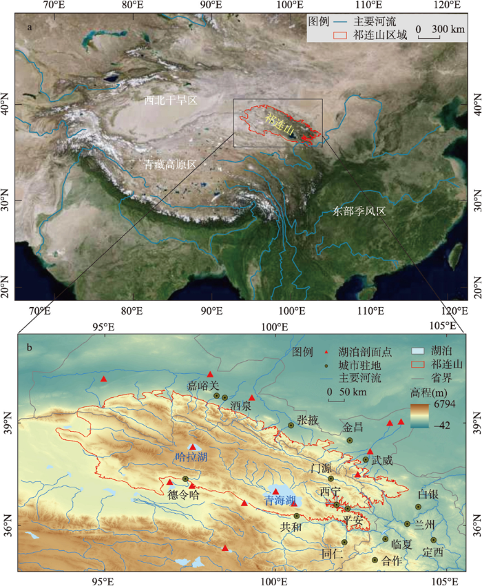


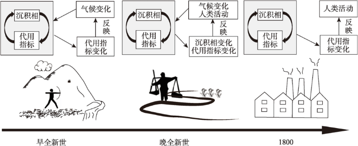

