戴特奇 , 廖聪, 胡科, 张文新, 刘正兵
北京师范大学地理科学学部 地理学院,北京 100875
DAI Teqi, LIAO Cong, HU Ke, ZHANG Wenxin, LIU Zhengbing
通讯作者:
收稿日期: 2016-10-16
修回日期: 2017-02-17
网络出版日期: 2017-08-20
版权声明: 2017 《地理学报》编辑部 本文是开放获取期刊文献,在以下情况下可以自由使用:学术研究、学术交流、科研教学等,但不允许用于商业目的.
基金资助:
作者简介:
作者简介:戴特奇(1980-), 男, 重庆人, 博士, 讲师, 主要研究方向为交通地理、城市与区域发展。E-mail:daiteqi@bnu.edu.cn
展开
摘要
空间优化正从地理学的一个研究方向成为学科分支,但公平导向的公共服务空间分配优化研究还较薄弱。学区配置是这方面的一个典型问题,受到社会的广泛关注。针对“多校划片”的随机入学方式,以各居住小区所获得的教育质量期望值的方差来定义入学指标空间分配的公平程度,构建了以该方差最小化为目标、包含最大上学距离约束的二次规划模型,探求各小区对所获得指标进行随机抽签的情景下,各校入学指标在各小区的公平最大化分配,并以北京市石景山区为案例进行了应用研究。结果表明,在维持学校布局和师资配置现状的前提下,与“就近入学”相比,公平最大化的“多校划片”能以有限的上学距离代价,显著降低教育分配的空间差异。在最大上学距离为5 km的约束下,各小区教育质量期望值的方差降幅高达99%,教育质量期望值有所提升的小区或学生比例高达约2/3;付出的上学距离代价较显著但可接受,平均上学距离增加到3.99倍,达到3.20 km,仍低于案例区实际平均上学距离。当模型的最大上学距离参数从5 km逐步增至8 km时,教育公平的改善呈指数增长,平均上学距离呈算数增长;当距离为7 km时,各小区教育质量期望值的方差趋近于0,可基本实现上学机会的空间均等化。本文进一步讨论了优化结果对入学政策的启示。
关键词:
Abstract
Spatial optimization is an important research area in geography. Most research on spatial optimization of education resource in this field is concerned with spatial efficiency, while the public is more concerned with spatial equity. In recent years, random allocation has been tested in some places, but the optimization models on the random allocation of schools have not been well formulated and developed. In China, to improve the spatial equity of education, a newly proposed reform tries to use lottery for school admission, namely "allocating several schools to one school district". However, there is little literature on how to implement the new school allocation, its impacts on school distance and educational equity. This paper constructs a quadratic programming model to minimize the variance of all students' expected values on educational quality under constraints of the maximum distance and schools' capacities. Then, Shijingshan District in Beijing is taken as a case area. The result indicates that the new allocation model can significantly improve the spatial equity of educational resources compared with the way of allocating students to the nearby school. The variance of the former decreases by 99%. Over 2/3 of the communities benefit from our model of maximum spatial equality, whose expected values of educational quality will increase. The ratio of benefit students is also about 2/3. On the other hand, the distance cost of school commuting is also significant. The average school distance increases by 3.99 times. However, it is still less than 5 km, which is commonly set as maximum distance to school. Moreover, it is also less than the survey school distance in the study area. When the parameter of the maximum distance in the model increases from 5 km to 8 km, the improvement of the variance of expected value of educational quality obeys the law of exponential growth, and the average distance increase obeys the law of arithmetic growth. When it is set at 7 km, the variance of expected value of educational quality approaches zero. It can be regarded as a state of absolute equal opportunity for every student which is usually thought to be hard or impossible to realize. Based on the results, the policy implication for China's school admission system is discussed.
Keywords:
教育公平是公众和多个学科都特别关心的热点议题[1]。中国目前的教育公平现状不容乐观,引起社会的强烈关注,甚至引发群体性事件[2]。近年来中国开始强调教育公平,并在2010年把促进义务教育公平作为国家基本教育政策[3]。教育公平涉及区域、城乡、校际、家庭等多个方面的差异,其中入学机会是教育公平重要的研究内容,本文主要讨论入学机会公平问题。入学机会公平通常指适龄学生享有平等的公共教育资源服务,也有研究强调入学机会公平应对社会弱势群体倾斜[4-5],本文采用前一定义。
从地理学的视角看,调整教育资源的空间分布和空间分配是促进入学机会公平的重要手段。关于教育资源空间分布的研究较多[6-9],而后者的研究仍较薄弱。理论上,教育资源的空间分配,存在就近入学、自由择校、随机入学等多种方式。为了减少距离的负面影响,就近入学原则存在于中国等许多国家和地区的学校分配制度之中[10]。中国自1986年《义务教育法》颁布以来,就近入学一直具有法定地位。但最近的研究揭示出中国已存在较为严重的优质教育资源局部集中,造成弱势阶层被隐性排斥的现象(“学区绅士化”),就近入学的公平性遭到了质疑[11-13]。在教育资源分布不均和就近入学方式下,平等的入学机会被认为是困难甚至于不可能的,英国等国的一些地方已开始试验随机入学方式来促进入学公平[14]。2016年中国教育部门也明确提出要探索“多校划片”等新的随机入学资格分配方式[15]。“多校划片”是指一个小区可能对应多个学校入学,采用“随机派位”的方式确定入学资格分配。在这一方式之下,如何控制距离的负面影响,并尽可能地增加入学机会的公平性,是一个具有迫切现实需求的空间优化问题。
空间优化是一个跨学科的研究领域,主要的理论基础来于数学、经济学、地理学和计算科学四大学科。规范的空间优化研究首先需要确定优化目标,并给予数学化表述,进而形成优化模型求解。早期的规范研究可以追溯到1900年龙哈德的工业区位论。最近几十年,这一领域越来越活跃,这一方面得益于经济学、地理学、交通、物流等学科解决实际选址问题的需求推动,另一方面也得益于运筹学、计算机科学、地理信息系统等学科在计算技术方面的进步[16]。空间优化已成为地理学重要的研究领域之一,正在成长为地理学的一个学科分支,设施的空间优化是这一领域最主要的研究内容[17]。
设施空间优化已经发展出了一套经典的选址—分配(Location-Allocation)模型,但多数是以效率为目标来探究最优的设施布局。学校布局优化方面目标函数包括设施数量最少、上学距离或时间最小等方面[18-21]。少数研究在应用效率导向优化模型时,通过最大距离等约束条件在一定程度上体现了公平导向[22-23]。直接以公平为目标的研究较少,在可达性公平优化方面,最近有研究建立了需求点可达性方差最小化的二次规划模型[24],并在医疗、养老设施的公平最大化选址方面得到了应用[25-26]。但这些研究关注的是设施的最优选址,很少规划如何将设施的服务分配给需求点,一般是承认人们的自由选择,根据消费者的行为规律进行建模,按最近距离进行分配或按距离衰减等方法进行分配[27]。学区配置与一般设施的区别恰在于此:在中国公立学校为主的制度背景下,入学指标的空间分配是一个公共决策,不应局限于根据个人选择进行描述,需要以公平为导向施加空间优化,而上述研究的选址优化模型不能直接用于公平导向的入学指标空间分配问题。总体而言,目前的研究偏重以效率为目标的选址(Location)优化,几乎没有针对公共决策的、以公平为导向的分配(Allocation)空间优化研究。
入学选择是一个典型的公共服务空间分配问题。本文将设计教育质量公平最大化目标下的“多校划片”优化模型,并在案例区进行应用研究,通过与“就近入学”的对比,分析改善教育公平需要付出的距离代价,最后还将讨论本文研究结果对于中国《义务教育法》中“就近入学”条款的启示。
构建公平导向的教育资源空间分配优化模型,首先需要度量教育质量公平。数学形式上,度量公平的数学指标多达几十种,其中方差是较为常用的计算方法[28],本文将采用方差来度量公平。具体地,本文将在小区层面开展应用研究,将采用各个小区所获得的教育质量的方差,来度量研究区域教育资源分配的公平。在就近入学的分配方式下,每个小区所获得的教育质量,对应小区被分配到的学校的教育质量;但在“多校划片”这一随机分配方式下,每个小区可能从多个学校获得入学指标,所获得的教育质量是各个学校教育质量的入学指标数的加权平均,即该小区所获得的教育质量是一个期望值。各小区的教育质量方差越小,说明各小区可获得的教育质量期望值越接近,入学机会越公平。
在学校教育质量评价方面,有很多指标可以反映学校的教育质量,比如考试成绩、教师水平等。考虑到好学校很可能有更好的学生来源,分数所反映的教育质量可能包含了较好学生分布的空间差异,且分数排名变动也较大,故本文采用各学校高级职称占总教师人数的比例来表征学校的教育质量。
在本文构建的公平导向的“多校划片”优化模型中,通过目标函数的设定来体现公平导向,本文设定的目标函数为最小化各居住小区的教育质量期望值。对公平的追求要受到效率的约束,在目标函数为最小化总(或平均)距离(或时间等指标)的研究中,其目标函数体现了效率,而最大距离约束则一定程度体现了公平[29];在本文中,目标函数体现了公平,最大距离约束和学校可容纳学生的规模约束则一定程度体现了效率。既有文献对上学距离和学校规模的适宜范围已有一定的研究:国际上一般要求学生上学距离不超过5 km[30];在学校的学生规模约束方面,中国城市普通中小学校建设标准(建标[2002]102号)规定的初级中学一个班的建制人数为50人,据此本文设定学校最大容量为不超过现状学校规模的10%,最小容量不小于50人。最终构建的模型是一个二次规划模型,采用分支界定法求解,具体的模型形式如下:
s.t.
式中:Ni表示小区i的学生人数;Ai表示小区i获得的教育质量期望值;a表示研究区的平均教育质量;Yij表示小区i到学校j的距离是否超过最大距离阈值Dmax,大于或等于时为0,否则为1;Xij表示小区i分配得到的学校j的入学人数;Qj表示学校j的教育质量;Sj表示学校规模。模型中目标函数式(1)表示各小区间教育质量期望的方差最小;其余为约束条件:式(2)表示小区i获得的教育质量期望值;式(3)要求所有学生均能入学;式(4)、(5)、(6)要求各个学校的招生规模不超过一定的上限(Cmax)和下限(Cmin);式(7)表示最大上学距离约束,这里设定Dmax为5000 m;式(8)表示小区获得的入学指标数不高于小区的学生数。
在“就近入学”下,优化目标为上学距离最小化,各小区对应唯一的学校,每个小区获得对应学校的教育质量。该情景下也施加了上学距离约束和学校规模约束。具体模型如下:
s.t.
式中:dij表示小区i到学校j的距离;Lij表示小区i是否分配到了学校j,是则为1,否则为0。目标函数(9)表示所有学生上学总距离最小;约束条件(10)表示就近入学下每个小区只能分配到唯一的学校;约束条件(11)表示最大上学距离约束;约束条件(12)、(13)、(14)表示学校规模约束。
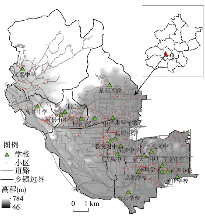
本文以北京市石景山区为案例对公平最大化的“多校划片”和距离最小化的“就近入学”两种情景进行应用研究。石景山区位于北京市西部,面积84.38 km2,下辖九个街道办事处(图1)。区内具有初级中学、九年一贯制学校、十二年一贯制及完全中学共20所。研究所需的学校位置数据来于北京市教育委员会(http://www.bjedu.gov.cn/xxgk/),学校教育质量数据来源于《北京石景山教育年鉴(2012)》。人口采用了居住小区尺度数据,2012年石景山区共有310个居住小区(本文不包含西北部的双泉寺和陈家沟两个居住点,其最近学校距离超过了5 km)。根据各个小区总人口和北京市分年龄段人口数据,按比例计算得到了各个小区12岁适龄入学的学生人数,作为需求点规模的度量。案例区需求总规模为2522人。
研究还需要各个小区到各个学校的最短上学距离。由于案例区坡度变化较大,而优化模型的结果对距离较为敏感,故本文基于实际路网和30 m精度的数字高程数据计算了包含坡度影响的距离矩阵。具体地,首先得到了含坡度影响的成本栅格图层,进而采用地理信息系统中的成本加权距离方法得到了含坡度影响的最短路径,得到了包含道路起伏的最短上学距离矩阵。
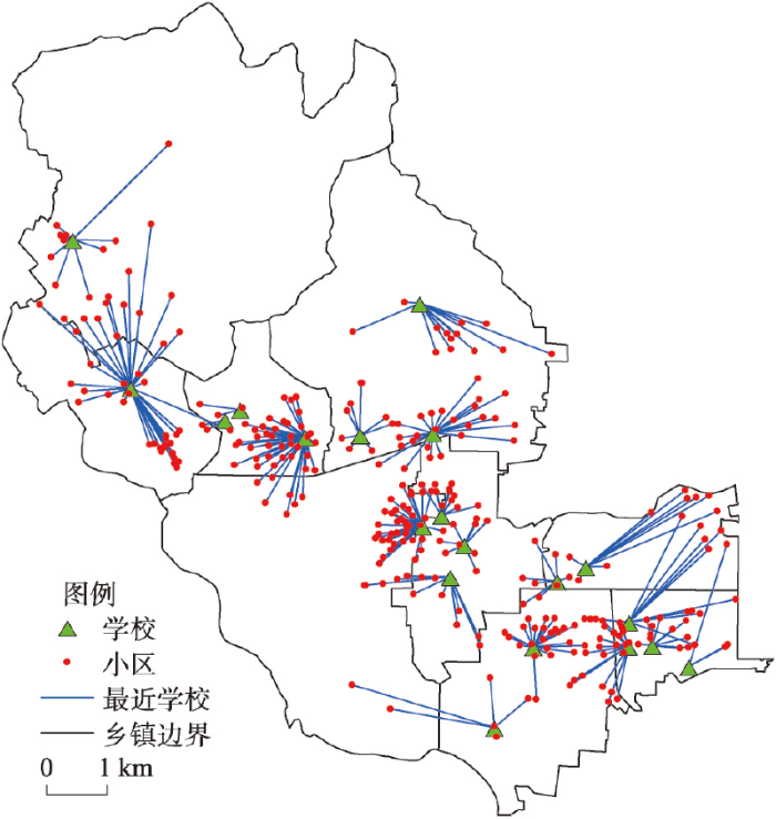
根据前文构建的模型和案例区数据,求解得到北京石景山区“就近入学”情景下入学配置结果(图2)。各小区教育质量得分的平均值为0.23;最大值为佳汇中学附近的小区,达到0.83;最小值0.040,对应为石景山区黄庄学校附近的小区;小区获得教育质量的最大值与最小值差距为0.79,案例区所有学生获得的教育质量的方差达75.18。在上学距离方面,学生的平均上学距离为0.80 km;最大值在和煦小区,达3.48 km;最小值在衙门口小区,只有0.021 km。
图2 北京石景山区“就近入学”空间配置
Fig. 2 Spatial allocation of schools in the scenario of "nearby enrollment" in Shijingshan District, Beijing
根据公平最大化模型求解,得到了“多校划片”情景下北京石景山区各个学校入学指标的空间分配(图3)。与“就近入学”情景相比,空间公平有了显著的提高。从方差看,案例区学生获得的教育质量期望的方差仅为0.070,较“就近入学”情景下降了99%。从各小区获得的教育质量期望值的最大值与最小值看,二者的差距仅为“就近入学”情景的11.39%;其中六合园等小区的教育质量得分最高,达到0.23;得分最小是和煦小区,得分为0.14。
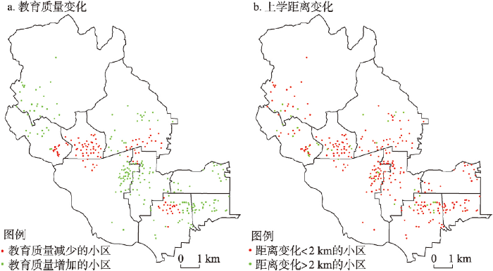
虽然整体而言,教育质量的空间公平有显著改善,但这不是一个帕累托改进,一些小区分配得到的教育质量有所下降,但这样的小区占少数。与“就近入学”情景相比,平均教育质量有所上升的小区共201个,占总小区数量的64.84%;包含学生1587人,占总学生人数的62.93%;主要分布在石景山区西部、北部和东部边缘地区,围绕在杨庄中学、天泰中学、同文中学等评分较低学校附近。平均教育质量有所下降的居住小区共109个,学生935人,主要分布在九中、京源学校和苹果园中学等高质量评分学校附近(图4a)。
图3 北京石景山区“多校划片”空间配置
Fig. 3 Spatial allocation of schools in the scenario of "Duoxiaohuapian" in Shijingshan District, Beijing
此外,公平最大化的“多校划片”情景下,上学距离代价也较为显著。案例区学生平均上学距离比“就近入学”情景增加到3.99倍,达到了3.20 km。但由于模型中设定了最大距离约束,故最大上学距离仍然不超过5 km,从上学距离的一般标准看,这一数值是可以接受的。实际上,这一数值还低于案例区实际调查的平均上学距离值5.50 km。
与“就近入学”情景相比,从上学距离变化的空间分布看(图4b),平均上学距离增加2 km以上的小区主要分布在研究区中部,大致形成了3个集中区域,主要围绕在北京教育科学研究院附属中学、九中、京源学校等学校附近,这些地方学校质量较高,学校密度较大。距离增加较小的小区位于西北部和北部,主要分布在天泰中学、北京师范大学励耘实验学校等学校附近,这些居住小区离案例区的中心较远,5 km范围内可供选择的学校较少。
总体而言,在公平最优的“多校划片”方案下,约2/3的小区获得的教育质量期望值增加了,而各个小区的平均上学距离则普遍增加了。本文进一步从这两个角度将案例区分为了4类,以考察公平最优模型的空间影响。具体地,按平均上学距离增加是否超过2 km(约等于案例区上学距离增量的平均值)和教育质量期望值是否增加进行分类。这4种类型对方案的支持和反对程度是有所差异的。按距离增加小于2 km且质量提升、距离增加大于2 km且质量提升、距离增加小于2 km但质量下降、距离增加大于2 km但质量下降,四类的小区比例分别为8.39%、56.45%、4.52%和30.64%;学生比例分别为4.64%、52.29%、2.14%和34.93%。其中上学距离增加而教育质量下降的小区主要分布在九中、苹果园中学等高质量学校附近。
图4 北京石景山区“多校划片”下教育质量及上学距离变化
Fig. 4 Changes of educational quality and school distance in each community in Shijingshan District, Beijing
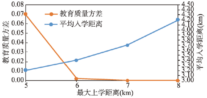
在师资等学校资源不进行空间分布再调整的前提下,有没有可能通过某种“多校划片”实现教育资源的空间均等化呢?国外有研究认为由于好学校往分布并不均匀,故随机入学对公平的改进可能有限,不能实现机会均等[31]。在本文的案例区,发现随机入学可以基本实现机会均等,但需要放松最大上学距离的约束。在公平最大化模型下,从5 km开始按步长1 km逐步增加最大上学距离约束,直到8 km,结果显示(图5)各小区教育质量期望值的方差呈现加速下降态势:每增加1 km,教育质量方差平均下降96%,呈指数下降(y = 6E+16e-7.96x,R2 = 0.958,y为教育质量方差,x为距离),平均上学距离平均增长0.4 km,呈算数增长(y = 0.33x+1.48,R2 = 0.959,y为教育质量方差,x为距离)。当最大上学距离放松到7 km时,方差仅为7.0×10⁻⁹,可以认为各小区教育质量期望值已经基本均等化。
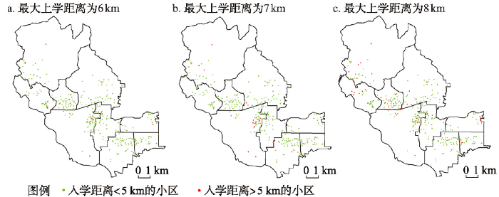
放松最大上学距离约束,也付出了更大的距离代价。当最大上学距离为8 km时,学生平均上学距离增加到了4.20 km。这一均值虽然低于一般要求的5 km,但出现了超过5 km的较长上学通勤现象。当最大上学距离约束分别设定为6 km、7 km和8 km时,上学距离超过5 km的学生分别为50人、155人和387人,呈显著上升态势,在7 km时候人数远远高于6 km。随着最大距离参数的增加,长距离上学学生的空间分布趋于分散(图6)。当上学距离为6 km时,上学距离超过5 km的小区主要分布在西部边缘和东部;当最大上学距离为7 km时,主要分布在西部边缘、南部边缘和中部;当最大上学距离为8 km时,则基本均匀分布。本文从公平和距离边际增量的角度权衡,推荐采用6 km这一阈值,此时过长上学距离人口代价较小而公平性改善也趋于机会均等化。
图6 北京石景山区不同最大上学距离约束下上学距离超过5 km的小区分布
Fig. 6 Distributions of communities with the distance over 5 km under different values of parameters Dmax
本文探讨了公共设施的空间公平分配问题,针对随机入学方式下入学指标的空间分配优化,构建了以各居住小区教育质量方差最小化为目标的二次规划模型,模型包含了最大上学距离约束,可为“多校划片”提供科学的空间配置依据。在模型构建基础上,在北京石景山区进行了“就近入学”和“多校划片”两种情景的对比研究,主要结论为:
(1)与就近入学相比,公平最大化的“多校划片”可以显著提高教育空间公平,但也会付出明显的距离代价。当最大上学距离不超过5 km时,各个小区教育质量的方差仅为0.070,比就近入学情景降低了99%;平均上学距离则增加到3.99倍,达到3.20 km,这一距离符合一般的上学距离要求,是可以接受的。
(2)公平最大化的“多校划片”带来的损益的空间分布是显著不均衡的。总体而言,多数地区和人口的教育质量预期值会比“就近入学”得到改善,其中教育质量预期值增加的小区占总数的64.84%,学生人数则占总数的62.93%;这些小区主要分布在学校质量评分较低的学校附近。
(3)公平最大化的“多校划片”模型下,最大上学距离约束的放松可以显著提升教育质量的空间公平,直至实现教育机会空间均等化。当最大上学距离增加到7 km时,得到的方差近似为0,基本实现了教育质量预期值的空间均等化,此时平均上学距离为3.70 km。随着最大上学距离的增加,空间公平的改善近似指数增长,而距离代价近似算术增长,公平的改善速度更快。具体地,最大上学距离从5 km开始增加到8 km,每增加1 km,各小区教育质量方差平均下降96%,平均上学距离平均增长0.40 km,超过5 km的较长上学距离人数平均增加197人。按边际增量看,当最大上学距离约束为6 km时,上学距离过长的人口总数最小,仅有50人,而公平性提高最显著,是本文推荐的决策点。
相比设施选址空间优化而言,公共设施的空间分配优化相对较少,还需要更多的研究。在如何将学生分配到学校的学区划分问题上,中国在教育公平导向下提出“多校划片”改革思路;传统的“就近入学”方式虽遭到质疑,却仍具有法律地位。本文的模型构建和案例研究表明:在一定的上学距离要求下,不需要改变学校的位置及其教育资源配置,通过公平最大化的“多校划片”就可能显著降低教育质量差异,甚至实现教育公共资源的机会均等化分配,使多数学生和多数地区受益。这一就近随机分配模型既满足了就近,也提升了公平,支持了对“就近入学”的质疑。但地区间学生与学校分布的差异会影响优化结果,故“就近入学”在其他地区是否也会面临这样的挑战,以至于需要修订为就近随机入学,还需要进行更多的研究。此外,公平和教育质量的定量评价存在多种指标,不同指标下的优化结果也可能存在差异,亦需要更多指标的比较研究。即便这样的质疑成立,如何从现状逐步改革到最优情景,还需发展动态优化模型,研究制度演进规律。
The authors have declared that no competing interests exist.
| [1] |
The geography of education: Introduction. https://doi.org/10.1080/00420980701329174 URL [本文引用: 1] 摘要
The article provides an introduction to the articles in the issue, which explore the relationship between geography and education in England.
|
| [2] |
Dispelling the myth sky-high valuations of school district housing is just the starting point .捅破“天价学区房”神话只是起点 . |
| [3] |
Outline of National Medium and Long Term Education Reform and Development Plan (2010-2020). Xinhua News Agency, , 2010-07-29.国家中长期教育改革和发展规划纲要(2010-2020) . |
| [4] |
The essence of educational equity and its policy significance .
教育公平包含教育资源配置的三种合理性原则,即平等原则、差异原则和补偿原则。教育资源配置的平等原则包括受教育权平等和教育机会平等两个方面,该原则强调教育起点平等和教育过程平等。教育资源配置的差异原则,是指根据受教育者个人存在的禀赋、兴趣和能力差异,差异性地配置教育资源,以满足其个性充分发展的需要。教育资源配置的补偿原则关注受教育者的社会经济地位的差距,并对社会经济地位处境不利的受教育者在教育资源配置上予以补偿。
教育公平的原则及其政策含义 .
教育公平包含教育资源配置的三种合理性原则,即平等原则、差异原则和补偿原则。教育资源配置的平等原则包括受教育权平等和教育机会平等两个方面,该原则强调教育起点平等和教育过程平等。教育资源配置的差异原则,是指根据受教育者个人存在的禀赋、兴趣和能力差异,差异性地配置教育资源,以满足其个性充分发展的需要。教育资源配置的补偿原则关注受教育者的社会经济地位的差距,并对社会经济地位处境不利的受教育者在教育资源配置上予以补偿。
|
| [5] |
A review of papers on compulsory education equality .义务教育公平研究文献综述 . |
| [6] |
Analysis of spatial accessibility for school redistricting in rural China: A case study of the secondary schools in Gongyi City, Henan Province. https://doi.org/10.3321/j.issn:1007-4619.2008.05.018 URL Magsci [本文引用: 1] 摘要
中小学布局调整是教育主管部门面临的一项重要任务,涉及教育资源的公平分配和合理利用,影响到义务教育法的落实和实施.在探讨中小学布局调整原理与方法的基础上,使用地理信息系统(GIS)技术建立人口分布、学校分布和交通条件等数据库,计算空间可达性指标,定量分析每一个居住区位学生上学的便捷程度,评估教育资源的空间分布差异,为学校布局规划提供重要的参考依据.使用比例模型、最近距离模型、机会积累模型、重力模型和改进重力模型,以巩义市初级中学为例,揭示学校分布与人口分布之间的关系,期望为农村中小学布局调整提供评估方法和规划依据.案例研究发现:农村义务教育在资源配置、最近入学距离、择校机会、供需平衡方面仍有一定的不均衡性.建议使用GIS和空间可达性指标评估中小学布局调整的公平性;进一步探索学生择校的空间规律,并使用Huff模型模拟学校与学生的最佳配置,为布局调整奠定定量分析基础.
农村中小学布局调整之空间可达性分析: 以河南省巩义市初级中学为例 .https://doi.org/10.3321/j.issn:1007-4619.2008.05.018 URL Magsci [本文引用: 1] 摘要
中小学布局调整是教育主管部门面临的一项重要任务,涉及教育资源的公平分配和合理利用,影响到义务教育法的落实和实施.在探讨中小学布局调整原理与方法的基础上,使用地理信息系统(GIS)技术建立人口分布、学校分布和交通条件等数据库,计算空间可达性指标,定量分析每一个居住区位学生上学的便捷程度,评估教育资源的空间分布差异,为学校布局规划提供重要的参考依据.使用比例模型、最近距离模型、机会积累模型、重力模型和改进重力模型,以巩义市初级中学为例,揭示学校分布与人口分布之间的关系,期望为农村中小学布局调整提供评估方法和规划依据.案例研究发现:农村义务教育在资源配置、最近入学距离、择校机会、供需平衡方面仍有一定的不均衡性.建议使用GIS和空间可达性指标评估中小学布局调整的公平性;进一步探索学生择校的空间规律,并使用Huff模型模拟学校与学生的最佳配置,为布局调整奠定定量分析基础.
|
| [7] |
Measurement and analysis of scale adjustment of school system and features of spatial evolution: A case study of ordinary senior high schools in Nanjing, China. 学校体系规模调整和空间演化特征的测度与分析: 以南京市普通高级中学为例 . |
| [8] |
GIS network analysis based old city educational facilities service area zoning and scale calculation: Tianjin Binhai New District Old City Primary School example. GIS 网络分析的老城区教育设施服务区划分及规模核定: 以天津滨海新区塘沽老城区小学为例 . |
| [9] |
Accessibility assessment and planning of public service facilities for education: A case study on senior high schools in Yizheng City. 教育公共服务设施可达性评价与规划: 以江苏省仪征市高级中学为例 . |
| [10] |
Distance, education and inequality. https://doi.org/10.1080/03050068.2013.807165 Magsci [本文引用: 1] 摘要
In this paper we examine the role which distance, in a variety of forms, can play in the reproduction, intensification or reduction of educational inequality in different types of school systems in different countries. This is a very broad issue, and in the paper we examine the ways in which distance to school has emerged as an important factor in understanding the relationship between social and educational inequality in London. We begin by outlining a broad framework for examination of the importance of space and distance which looks at characteristics of schools, pupils and school allocational systems and how they combine in different situations. We then attempt to populate this schema by drawing on different specific examples linking to relevant national literatures.
|
| [11] |
Analysis of the nearest school policy from the perspective of educational equity .教育公平视域下就近入学政策分析 . |
| [12] |
The limitations of the nearby enrollment and the exploration of the university district system .“就近入学”的局限及“大学区制”探索 . |
| [13] |
Jiaoyufication: When gentrification goes to school in the Chinese inner city. https://doi.org/10.1177/0042098015613234 URL [本文引用: 1] 摘要
Gentrification, or the class-based restructuring of cities, is a process that has accrued a considerable historical depth and a wide geographical compass. But despite the existence of what is otherwise an increasingly rich literature, little has been written about connections between schools and the middle class makeover of inner city districts. This paper addresses that lacuna. It does so in the specific context of the search by well-off middle class parents for places for their children in leading state schools in the inner city of Nanjing, one of China鈥檚 largest urban centres, and it examines a process that we call here jiaoyufication. Jiaoyufication involves the purchase of an apartment in the catchment zone of a leading elementary school at an inflated price. Gentrifying parents generally spend nine years (covering the period of elementary and junior middle schooling) in their apartment before selling it on to a new gentrifying family at a virtually guaranteed good price without even any need for refurbishment. Jiaoyufication is made possible as a result of the commodification of housing alongside the increasingly strict application of a catchment zone policy for school enrolment. We show in this paper how jiaoyufication has led to the displacement of an earlier generation of mainly working class residents. We argue that the result has been a shift from an education system based on hierarchy and connections to one based on territory and wealth, but at the same time a strangely atypical sclerosis in the physical structure of inner city neighbourhoods. We see this as a variant form of gentrification.
|
| [14] |
McKenna L. The short-run impact of using lotteries for school admissions: Early results from Brighton and Hove’s reforms. https://doi.org/10.1111/j.1475-5661.2012.00511.x URL [本文引用: 1] 摘要
Abstract We analyse the initial impact of a major school admission reform in Brighton and Hove. The new system incorporated a lottery for oversubscribed places and new catchment areas. We examine the post-reform changes in school composition. We locate the major winners and losers in terms of the quality of school attended. We match similar cities and conduct a difference-in-difference analysis of the policy change. The results are complex: we see an increase in student sorting but we also see a significant weakening of the dependence of school attended on student’s prior attainment.
|
| [15] |
Notice on the work of urban compulsory education enrollment in 《关于做好 |
| [16] |
Location Science. |
| [17] |
Spatial optimization in geography. https://doi.org/10.1080/00045608.2012.685044 URL Magsci [本文引用: 1] 摘要
This article discusses spatial optimization in geography, focusing on contributions of geographers in explicit geographical contexts. An overview of spatial optimization is given, as well as illustrative examples. Many of the individuals contributing to this area of the discipline are identified, demonstrating the breadth of academic institutions spanning the globe where spatial optimization is represented in the research and curriculum of geographers. The article provides a characterization of what a spatial optimization problem is, but also properties, relationships, and challenges behind this. The ultimate purpose of this article is to highlight the spatial optimization subspecialty within geography and in doing so, highlight the need for continued spatial model development and application in the discipline. Further, there is also a need for research focused on techniques to solve spatial optimization problems, particularly in the context of geographic information systems.
|
| [18] |
Optimal location-allocation for county-level compulsory school site selection using GIS and integer linear programming. Journal of Geo-information https://doi.org/10.3724/SP.J.1047.2012.00299 URL [本文引用: 1] 摘要
This paper aims to develop an optimal location-allocation methodology for school site selection using GIS and integer programming. According to the nearby enrollment policy, the authors propose two linear programming models (boolean and integer) with constrains of total school number and school capacity. The models are simplified by eliminating the unreasonable school-residence links for reducing the number of decision variables and therefore solving the problems efficiently. Since the constraint matrix of the boolean model is a sparse matrix with two non-zero elements per row, it can be solved optimally with very small tolerance using branch and cut algorithm. The constraint matrix of the integer model is similar to the totally unimodualr matrix and can be solved optimally. In ArcGIS 10 geoprocessing framework, the school site-selection tool is designed by integrating ArcGIS network analysis, Coin-or linear programming modeler (PuLP) and linear programming solver Cplex 12. School site selection of a county region with 1276 resident points and 50 schools is tested successfully. The related network analysis, model building, model solving and result visualization can be implemented speedily in normal personal computer with Intel Dual-Core 2.44GHz CPU and 2GB memory. Case study shows that the mathematical models and solution method introduced in this paper are efficient, easy-to-use and practical for large-scale school location-allocation problems. The authors also argue that instead of using heuristic algorithms, many large-size location-allocation problems can be solved using branch and cut algorithm optimally or optimally with very small tolerance.
县市级义务教育学校区位配置优化设计与实验 .https://doi.org/10.3724/SP.J.1047.2012.00299 URL [本文引用: 1] 摘要
This paper aims to develop an optimal location-allocation methodology for school site selection using GIS and integer programming. According to the nearby enrollment policy, the authors propose two linear programming models (boolean and integer) with constrains of total school number and school capacity. The models are simplified by eliminating the unreasonable school-residence links for reducing the number of decision variables and therefore solving the problems efficiently. Since the constraint matrix of the boolean model is a sparse matrix with two non-zero elements per row, it can be solved optimally with very small tolerance using branch and cut algorithm. The constraint matrix of the integer model is similar to the totally unimodualr matrix and can be solved optimally. In ArcGIS 10 geoprocessing framework, the school site-selection tool is designed by integrating ArcGIS network analysis, Coin-or linear programming modeler (PuLP) and linear programming solver Cplex 12. School site selection of a county region with 1276 resident points and 50 schools is tested successfully. The related network analysis, model building, model solving and result visualization can be implemented speedily in normal personal computer with Intel Dual-Core 2.44GHz CPU and 2GB memory. Case study shows that the mathematical models and solution method introduced in this paper are efficient, easy-to-use and practical for large-scale school location-allocation problems. The authors also argue that instead of using heuristic algorithms, many large-size location-allocation problems can be solved using branch and cut algorithm optimally or optimally with very small tolerance.
|
| [19] |
Method for optimization allocation of regional public service infrastructure: A case study of Xinghua Street Primary School. 区域公共服务设施优化配置方法研究: 以大连市甘井子区兴华街道小学配置为例 . |
| [20] |
Exploration and improvement of planning methods for the distribution of primary and secondary schools. https://doi.org/10.11819/cpr20140809a URL 摘要
针对当前城市中小学配置中存在的常见问题,本研究提出了专项规划的必要性。进一步以供需关系为主线,密度分析为基础,对传统规划方法进行改进。本文对核密度分析法、圆形临近分配法、网络服务区分析法进行比较,讨论了它们的优缺点。以河南省漯河市中心城区为例,对所探讨的方法进行应用与验证,对近期的小学新建、扩建、撤销提出建议。还进一步讨论了这类规划存在的其他矛盾和对策建议。
城市中小学布局规划方法的探讨与改进 .https://doi.org/10.11819/cpr20140809a URL 摘要
针对当前城市中小学配置中存在的常见问题,本研究提出了专项规划的必要性。进一步以供需关系为主线,密度分析为基础,对传统规划方法进行改进。本文对核密度分析法、圆形临近分配法、网络服务区分析法进行比较,讨论了它们的优缺点。以河南省漯河市中心城区为例,对所探讨的方法进行应用与验证,对近期的小学新建、扩建、撤销提出建议。还进一步讨论了这类规划存在的其他矛盾和对策建议。
|
| [21] |
Optimizing school distribution with constraints of school size after school consolidation in rural China: A case study of Yanqing District, Beijing City. https://doi.org/10.18306/dlkxjz.2016.11.005 URL [本文引用: 1] 摘要
在城镇化和农村人口减少的背景下,中国农村地区大量学校撤并,如何优化学校布局成为研究的重点.2008年原建设部发布了农村学校的最小和最大学生规模标准,但该标准对学校布局的影响尚缺乏研究.本文在包含最大距离约束的P-中值模型中增加了学校规模约束,构建了学校布局优化模型,并以北京延庆区小学布局为例,采用分支界定算法进行了求解.结果表明:实施学校规模标准化对学校优化选址有显著的影响,在优化模型中加入学校规模约束后,有65.22%的学校位置发生了改变,呈更加分散型布局;但在乡镇尺度下考察,学校的空间格局则基本未发生变化;学校规模标准化带来的距离增长较小,平均每个学生上学距离仅增长了135 m.并根据结果进一步讨论了研究结果对学校布局优化的政策启示.
农村学校撤并后规模约束对学校优化布局的影响: 以北京延庆区为例 .https://doi.org/10.18306/dlkxjz.2016.11.005 URL [本文引用: 1] 摘要
在城镇化和农村人口减少的背景下,中国农村地区大量学校撤并,如何优化学校布局成为研究的重点.2008年原建设部发布了农村学校的最小和最大学生规模标准,但该标准对学校布局的影响尚缺乏研究.本文在包含最大距离约束的P-中值模型中增加了学校规模约束,构建了学校布局优化模型,并以北京延庆区小学布局为例,采用分支界定算法进行了求解.结果表明:实施学校规模标准化对学校优化选址有显著的影响,在优化模型中加入学校规模约束后,有65.22%的学校位置发生了改变,呈更加分散型布局;但在乡镇尺度下考察,学校的空间格局则基本未发生变化;学校规模标准化带来的距离增长较小,平均每个学生上学距离仅增长了135 m.并根据结果进一步讨论了研究结果对学校布局优化的政策启示.
|
| [22] |
An optimization-based study on the redeployment of a secondary school network. https://doi.org/10.1068/b31173 URL [本文引用: 1] 摘要
Abstract In this paper we report the results of a study on secondary school planning made within the framework of Coimbra鈥檚 Educational Charter. Coimbra is a medium-sized municipality of 320 km2 and 150 000 inhabitants located in the center-littoral region of Portugal. The planning problem addressed in the study consisted of defining the location, type, and size of the schools that should integrate Coimbra鈥檚 secondary school network in 2015, given, first, the excess of aggregate school capacity that currently characterizes the municipality, and, second, the change in school typology that needs to be implemented as a consequence of a recent reorganization of the Portuguese educational system. This problem was analyzed with a discrete facility-location model and considers decisions both of closing existing schools and of opening new schools. The model is a variant of the well-known p -median model, which aims at maximizing the accessibility of students to schools, with constraints on maximum and minimum capacity occupation that make model solutions lose the single assignment and closest assignment properties. As these are desirable properties in a public-facility planning context, they are enforced with explicit constraints. The results obtained through the model are discussed from the standpoint of the trade-off between school accessibility improvements and school network changes.
|
| [23] |
Space operation of rural primary and secondary school location. 农村中小学选址的空间运筹 . |
| [24] |
Planning toward equal accessibility to services: A quadratic programming approach. https://doi.org/10.1068/b37096 URL [本文引用: 1] 摘要
In the literature various accessibility indices have been developed to assess the relative ease by which the locations of services (supply) can be reached from a residential (demand) location. In this paper we address the planning problem: how the resources can be redistributed to achieve the highest equality of accessibility to the service providers. In particular, a quadratic programming approach is used to minimize the variance of accessibility scores across demand locations by readjusting the amounts of service supplies. Two case studies-job access in Columbus, OH and primary healthcare access in Chicago, IL-are used to illustrate the method. The result suggests that in order to achieve better equality of accessibility, peripheral areas, in general, need additional supplies to compensate for their less-central locations, and some central city areas also need to add supplies to accommodate high demands by the high population density there.
|
| [25] |
Spatial optimization of residential care facility locations in Beijing, China: maximum equity in accessibility. https://doi.org/10.1186/1476-072X-13-33 URL PMID: 4160561 [本文引用: 1] 摘要
Background The residential care system is rapidly developing and plays an increasingly important role in care for the elderly in Beijing. A noticeable disparity in the accessibility to existing residential care facilities, however, is demonstrated in existing studies. The spatial optimization of residential care facility (RCF) locations is urgently needed to promote equal access to residential care resources among the elderly population. Methods A two-step floating catchment area method with an additional distance-decay function is adopted to measure accessibility to residential care facilities. The spatial optimization model is developed to maximize equity in accessibility by minimizing the total square difference between the accessibility score of each demand location and the weighted average accessibility score. The Particle Swarm Optimization (PSO) method is implemented for the solution. Results The optimized RCF layouts improve equal spatial access to residential care resources with very low accessibility standard variation (0.0066). A relatively large number of beds (51% of the total beds) to be located in the suburban districts between the central and periphery districts of Beijing are optimized. A smaller number of beds to be located in the central and periphery districts (33% and 16% respectively) are optimized. The gaps between the existing and optimized layouts suggest that more RCF beds (5961 beds) are needed in suburban districts, while the RCF beds in some subdistricts located in the central and periphery districts are oversupplied (5253 and 1584 surplus beds respectively). Conclusions The optimized results correspond to the municipal special plan proposed by the Beijing government. The optimization objective of this study is different from traditional facility location optimization models, and the method is efficient in maximizing equal access to residential care facilities. This method can support knowledge-based policy-making and planning of residential care facilities.
|
| [26] |
A two-step approach to planning new facilities towards equal accessibility. https://doi.org/10.1177/0265813516657083 URL [本文引用: 1] 摘要
Abstract A recent advancement in location-allocation modeling proposes a new objective of minimizing inequality of accessibility. Existing work considers the planning problem as either selecting new sites or adjusting facility capacities, separately. This paper develops a two-step hybrid approach to the problem by optimizing both locations and capacities of facilities towards equal accessibility. A genetic algorithm is first employed to find the best locations to site new facilities, and then a quadratic programming method is used to determine the best capacity of each facility within a pre-defined range. The sequence is consistent with many decision-making practices. Results of a series of experiments demonstrate that location optimization reduces inequality in accessibility more significantly than capacity optimization. The two-step optimization method can be applied for sequential allocation decision-makings towards maximum equal accessibility.
|
| [27] |
Measurement, optimization, and impact of health care accessibility: A methodological review. https://doi.org/10.1080/00045608.2012.657146 URL PMID: 23335813 Magsci [本文引用: 1] 摘要
Despite spending more than any other nation on medical care per person, the United States ranks behind other industrialized nations in key health performance measures. A main cause is the deep disparities in access to care and health outcomes. Federal programs such as the designations of Medically Underserved Areas/Populations and Health Professional Shortage Areas are designed to boost the number of health professionals serving these areas and to help alleviate the access problem. Their effectiveness relies first and foremost on an accurate measure of accessibility so that resources can be allocated to truly needy areas. Various measures of accessibility need to be integrated into one framework for comparison and evaluation. Optimization methods can be used to improve the distribution and supply of health care providers to maximize service coverage, minimize travel needs of patients, limit the number of facilities, and maximize health or access equality. Inequality in health care access comes at a personal and societal price, evidenced in disparities in health outcomes, including late-stage cancer diagnosis. This review surveys recent literature on the three named issues with emphasis on methodological advancements and implications for public policy.
|
| [28] |
Equity measurement in facility location analysis: A review and framework. https://doi.org/10.1016/0377-2217(94)90200-3 URL [本文引用: 1] 摘要
ABSTRACT In selecting sites for facilities, especially in the public sector, the issue of equity is becoming increasingly important. Beginning with the work of Mumphreys et al. (1971), McAllister (1976), and Savas (1978), a substantial literature has developed that incorporates equity in facility siting decision models. Despite this level of interest, however, there has been little agreement in these models as to how equity should be measured. Further, except for some recent works, there has generally been little comparison of alternative measures, or assesment of their relative value, let alone any consensus on the best measure(s) to use. Perhaps even more surprising is the great number and variety of measures employed. The motivation for this paper is to address these problems and provide for researchers a base from which issues of equity can be included in facility siting models. More specifically, we seek to review the equity literature as it pertains to facility location, assemble the set of measures that have been developed, and introduce a framework and common notation for organizing them. We also will discuss approaches that can be used to select an appropriate measure of equity.
|
| [29] |
Multicriteria spatial allocation of educational resources: An overview. Socio- https://doi.org/10.1016/S0038-0121(99)00025-7 URL [本文引用: 1] 摘要
The multiple criteria decision-making (MCDM) problem involves a set of alternative allocation plans evaluated on the basis of multiple, conflicting and noncommensurate criteria by several interest groups. These are often characterized by unique preferences with respect to the relative importances of criteria against which the alternative plans are evaluated. It is argued that central to many spatial (geographical) decision making problems in the public sector is the search for consensus among various interest parties. We suggest that multicriteria decision analysis may be used successfully to develop alternative allocation plans in facilitating compromise among competing interests. In this regard, a variety of normative approaches developed over the past 20 years, together with an increasing interest in GIS (Geographic Information Systems)-based analysis, will likely lead to greater emphasis on interactive search procedures and interactive computer-based decision support system concepts.
|
| [30] |
School travel behaviour in the Netherlands and Flanders. https://doi.org/10.1016/j.tranpol.2013.01.004 URL [本文引用: 1] 摘要
Studies on school travelling frequently deal with active travelling that is considered important in preventing obesity. Most research has been done in low bicycle countries where walking is the main active mode. The paper presents an analysis for the Netherlands and Flanders, two European countries with high bicycle use. The study analyses two aspects of school travel behaviour: home-to-school distances and modal choice. Both are analysed for primary and secondary school students. A descriptive analysis learns that in Flanders trip lengths to primary schools are significantly larger than in the Netherlands and that the bicycle is more frequently used in the Netherlands. Analyses of influencing variables for both home-to-school distance and modal choice demonstrate that 鈥榟ard鈥 factors that define the objective conditions for school choice (crucial for home-to-school distance) and modal choice are most influential. They regard the locations of eligible schools and the qualities of the eligible modes. Just one other factor is significant in the explanation of home-to-school distances: car ownership. On the other hand, modal choice is influenced by several other socio-cultural factors, where age of the pupil, size of the household, and car ownership are most important. Most outcomes are in line with other studies. The observed high bicycle use demonstrates that the bicycle has the potential to account for a large number of trips and can even be the dominant mode in school travelling.
|
| [31] |
Parental choice of primary school in England: What types of school do different types of family really have available to them? https://doi.org/10.1080/01442872.2011.601215 URL Magsci [本文引用: 1] 摘要
This article focuses on the constraints on parental choice of school caused by geographical location, which arise due to the reliance on geographical proximity as the key oversubscription criterion for allocating school places. We investigate the assumption that most families really can choose between a range of different schools, and ask what types of school are genuinely accessible to different types of pupil. Using an innovative combination of survey and administrative data, we first determine what types of school are located near different family types. We then investigate how many of these different types of school are really available to the student, based on current catchment areas of schools and the home location of the child. This enables us to assess how access is determined by geography, and how it differs both by school type and by type of family. We show that using proximity as the main criterion to determine access to most schools affects pupils' probability of securing a place at a particular school, with higher socio-economic status (SES) pupils being more likely to be accepted into (nearer) more advantaged schools. We argue that the large differences in the range of schools genuinely available to different families, coupled with the use of proximity as a tie-break device, continues to be a significant barrier to reducing inequality of access in the English school system.
|

/
| 〈 |
|
〉 |
