於家 , 温家洪
, 温家洪
YU Jia, WEN Jiahong
收稿日期: 2016-07-18
修回日期: 2017-03-31
网络出版日期: 2017-08-20
版权声明: 2017 《地理学报》编辑部 本文是开放获取期刊文献,在以下情况下可以自由使用:学术研究、学术交流、科研教学等,但不允许用于商业目的.
基金资助:
作者简介:
作者简介:於家(1982-), 男, 上海人, 博士, 副教授, 主要研究方向为空间建模和GIS开发等研究工作。E-mail:yujiashnu@126.com
展开
摘要
城市应急避难所的空间配置一直是灾害防治和城市安全研究领域的热点问题。本文以城市居民尽快地,尽少拥挤地到达满足容纳需求的应急避难所为目标,整合遥感影像数据、高精度人口分布数据、交通路网数据和专家知识等数据,综合运用智能体模型和多准则决策方法,对城市避难所空间配置开展研究。本文设计了三类与应急疏散相关的智能体:政府智能体、避难所智能体和居民智能体,来实现应急疏散的模拟,并根据模拟结果支持应急避难所的空间选址和配置。选址方法上运用了多准则决策方法和权重敏感性分析,在选址高适宜区域内选定避难所的新建方案。以新的避难所空间布局和配置为条件,执行新一轮的应急疏散模拟过程,实现选址的循环优化,从而获得最终的避难所空间配置方案。本文以上海市静安区的应急避难所空间配置分析为案例,生成了该区域应急避难所的详细空间配置方案,该方案能帮助居民在尽少拥挤风险下尽快疏散到附近的避难所。本文提出的方法充实了中国城市避难所选址的相关理论与可操作性的技术基础,为其他地区开展避难所的配置工作提供借鉴与参考。
关键词:
Abstract
Spatial configuration of urban emergency shelters is one of the hotspot issues in disaster prevention and urban emergency management. The purpose of this study is to conduct spatial configuration of urban shelters which can help urban residents have access to the emergency shelters as soon as possible with less congestion. The spatial configuration model is built on the basis of the agent-based model and multi-criteria decision-making method. Remote sensing image data, high-precision population data, road network data and expert knowledge are integrated in the model. Three types of agents involved in emergency evacuation are designed, which include the government agent, shelter agents and resident agents, to conduct evacuation simulation. A government agent can delimitate the service areas of shelters in accordance with the administrative boundaries and road distances between the positions of residents and the locations of the shelters. Shelter agents can select specified land uses as potentially available shelters for different disasters, generate the service areas of shelters, record the information of the residents in their service areas and do relative statistical work of evacuation processes. Resident agents have a series of attributes, such as ages, positions, and walking speeds. They also have several behaviors, such as reducing speed when walking in the crowd, and helping old people and children. Integrating these three types of agents which are correlated with each other, we can simulate evacuation procedures. The simulation results are utilized to support location-allocation and configuration of emergency shelters. The location-allocation method of this study is based on multi-criteria decision making and weight sensitivity analysis, so that the locations of new shelters can be selected in highly-suitable regions for location-allocation. When the new shelters are allocated, a new round of emergency evacuation simulation will be executed to realize loop optimization of location-allocation based on the new spatial distribution of shelters to generate the final spatial configuration plan. A case study in Jing'an District, Shanghai, China, was conducted to demonstrate the feasibility of the model. The simulation results convinced that the new model can provide detailed planning for spatial configuration of urban shelters, which can help the residents evacuate to nearby shelters as quickly as possible with less congestion risks. The model provides a new methodology to conduct high-quality location-allocation of urban emergency shelters. It can also be extended to conduct similar spatial configuration work in other urban regions for different kinds of emergency shelters.
Keywords:
近年来,自然灾害和人为灾害在世界各地的城市中呈现不断增长的态势[1]。为了防止城市居民的生命和财产遭受损失,在城市范围内建立应急避难所,提供及时的公共安全保障显得尤为重要[2-3]。在各类科技减灾工作中,规划与建设城市避难所是降低城市灾害风险的一项有效方法,是保障城市居民人身与财产安全的重要手段。科学合理地规划和建设城市避难所对城市防灾具有非常重大的意义[4]。城市避难所如同城市中的诺亚方舟,在突发灾害事件时,能够让受灾居民尽快疏散至其中,并为其提供基本的生存物资。在当前城市急剧扩张,城市人口不断增长的情形下,建立和完善城市应急避难体系、提高抵御灾害和应急救援的能力是目前城市管理工作中的一项重要任务。
城市应急避难所的空间配置是一类专题化的空间优化选址问题。对于空间优化选址,国内外研究人员已经开展了大量的研究。比如经典的覆盖问题[5]、中心问题(P-Center)[6]和中位问题(P-Median)[7]以及发展和演化后出现的分层选址问题[8]、竞争选址问题[9]、渐进覆盖问题[10]和多目标选址问题[11]等。另外,学界对于空间抽样[12]和空间异质性[13]方面的研究,比如抽样点的选取和空间子区域的划分,为空间优化选址提供了很好的参考与借鉴。但是在避难所及防灾减灾设施的空间配置研究领域,大多数的研究还采用较为传统的方法,比如层次分析法[14-15]、加权线性回归法[16]、基于GIS的网络分析方法[17]、TOPSIS方法[18]、灰色评价法[19]等。也有部分学者意识到避难所选址的复杂性,尝试运用人工智能的方法来提高模型方法求解的计算效率。比如,Cha等[20]针对多地震带大型民用建筑控制与传感设备选址问题,考虑控制与传感设备总数最小化及建筑物动态反应最小化等目标,建立了多目标优化模型,并设计了多目标遗传算法进行求解;Hu等[4]利用离散PSO方法来解决地震应急避难所的空间配置问题,为了提高搜索能力,还利用了模拟退火算法来防止选址结果陷入局部最优。
上述的研究已经在避难所的规划建设上获得了一定的成果,但是城市避难所的空间配置不同于一般的城市设施选址,在地震、洪灾、海啸等灾害或其他大型突发事件发生时,城市避难所是应急疏散的目的地。政府和相关部门组织有效的疏散方式和手段将尽可能多的人员在尽可能短的时间内,撤离至就近的安全地点对于保障城市居民的生命安全是至关重要的[21]。由此可见,在城市避难所空间配置时,将周边居民应急疏散至避难所过程中的安全性、高效性等考虑进来,具有很强的必要性和非常重要的现实意义。由于灾害种类的多样性,居民的避难行为的复杂性等因素,在避难所空间配置时,相比一般的城市设施配置需考虑更多的影响因素,比如避难所的人口容量、出入条件、避难居民的人数和年龄结构、居民疏散到避难所所需时间、疏散过程中是否会有拥挤情况等。
在应急疏散研究领域,很多研究人员尝试通过计算机仿真模拟的方法来为大规模紧急疏散研究提供实验和分析平台[22-23],并加入了各类灾害或应急事件的情景模拟,比如对地震灾害应急疏散过程模拟[24],以及对暴雨洪涝情景下人员疏散至避难所的困难程度评估[25]等。在各类计算机仿真模拟模型中,智能体(Agent)具有很广泛的应用。目前,较为成功的基于智能体疏散模型有社会力模型[26]、Murakami的Free Walk和Flat Walk模型[27]、以及Keßel等的微观仿真模型[28]等。另外,GIS研究人员尝试用空间数据存储和可视化方法来表达应急疏散和避难过程,使得后期的空间分析更为便利和高效[29-30]。但是,学界尚缺乏将应急疏散和避难所选址结合起来的研究。城市是大量人员聚居,人类财富集聚的区域,避难所的选址配置必然要满足及时、有效的人员疏散和一定规模的人员容纳要求,从而提升城市安全保障和应急响应的能力,保障社会和民众的人身与财产安全。因此,将“灾害预警/灾害发生→人员疏散→避难所避难”这一过程整体考虑,综合建模来实现城市避难所的选址具有一定的创新性和必要的现实意义。
本文将应急疏散模拟应用到避难所的配置评价和选址工作中,以智能体技术实现应急疏散过程的模拟,建立城市避难所空间配置方法,并以模拟结果结合各类空间评价指标,作为避难所空间配置的决策因素,实现避难所空间布局的演绎生成和检验。研究中还以上海市静安区应急避难所空间配置分析为案例,为当地的避难所规划与配备提供参考方案。通过本文,将丰富城市避难所配置的相关理论与可操作性的技术基础,并为中国其他地区开展避难所的配置工作提供借鉴与参考。
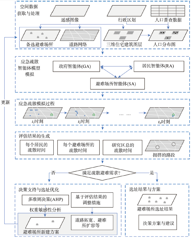
本文实现的方法框架如图1所示。以该框架为基础,通过GIS开发生成工具软件,包括空间数据获取与处理、应急疏散智能体模型模拟、模拟过程分析和结果评估、决策支持与选址优化4个模块。该框架包含的主要部分如下:
为了执行应急疏散模拟和避难所空间配置决策,需要准备3类空间数据:道路网络图层、备选避难所图层和人口分布图层。利用人口普查资料只能获得以人口统计单元为精度的人口分布数据。为获得更高精度的、能够支持人员应急疏散模拟的人口分布数据,本文中尝试估算每栋住宅建筑中的人口数量。根据已有研究,尽管影响精细尺度居住人口分布的因子很多,但建筑物的容量是精细估算人口分布的最重要的评价因素[31]。因此利用遥感图像和实地调查获取住宅建筑图层,图层中需要包含建筑楼层信息,另外需要研究区的人口普查资料和与人口普查统计单元相对应的行政区划图[32]。假设在某个人口统计单元(比如某个居委)内,共有N个住宅建筑。那么,其中第n个住宅建筑中的居民数可以通过公式(1)和公式(2)来得到:
式中:PB(n)是该人口统计单元内的第n个住宅建筑的人口数;PB(n,a)是第n个住宅建筑中第a个年龄段的人口数;A是划分年龄段的数量;PS(a)是在该人口统计单元内,第a个年龄段的人口数;SB(i)是第i个住宅建筑的占地面积;FB(i)是第i个住宅建筑的楼层数。相比传统的人口统计数据,利用公式(1)和公式(2),可以更加精细的估算研究区内住宅建筑中的不同年龄段的人口数量,从而为下一步执行合理的应急疏散过程提供准备。
要实现应急疏散的模拟过程,首先要依据智能体理论,将与应急疏散过程相关的不同主体抽象为不同类型的智能体。本文中设计了三种类型的应急疏散智能体:政府智能体、避难所智能体和居民智能体。
2.2.1 政府智能体 政府智能体不具有空间属性,但是具备一系列非空间性的属性和行为,对避难所智能体和居民智能体形成约束。其在城市疏散和避难所管理的法规设立上起到重要作用。政府智能体能够约束避难所的服务范围,即指定哪些居民将去往哪个避难所进行疏散避难。它还能对居民组织防灾避灾演练,在灾害发生时帮助和组织居民有序的离开住宅去往就近避难所。疏散过程结束后,政府智能体能够对疏散过程进行统计,形成的统计结果用来支持进一步的分析等。
2.2.2 避难所智能体 避难所智能体的第一项工作是在空间数据模块提供的备选避难所图层中选取备选避难所,如图1研究方法框架所示,比如在地震、大型火灾等灾害情景下,智能体将选择公园、大型绿地和广场作为安置居民的场所;对于洪灾情景下,学校、图书馆、文化中心等场所将被选为备选避难所;突发小规模紧急事件,将选择事件发生周边的绿地或空地作为避难所等。避难所智能体的第二项任务是基于道路网络和政府智能体规定的避难服务责任范围(比如不同行政级别的辖区范围等)生成各避难所的空间服务范围,并记录在该服务范围内的所有居民的相关信息,包括年龄、性别等。该智能体的第三项工作是为每个避难所统计属于其管辖的、应到该场所来避难的居民数量,以及每个居民到达该避难所所需的时间。
2.2.3 居民智能体 城市居民的应急疏散过程具有很高的复杂性、动态性和不确定性,难于完全精确的进行模拟,而智能体技术的“自下而上”的特点能够更好的帮助模拟复杂过程。本文的目标是利用居民疏散模拟的过程,来找出避难所选址和配置中存在的问题,使避难所空间配置得到更科学、合理的规划。因此,居民智能体的设计相比前两种智能体更为复杂。本文中,设置的居民智能体有一系列属性,包括居民的年龄类别、疏散的开始位置(住宅建筑)、终止位置(避难所)、最快行走速度、当前行走速度和当前的位置等。另外,居民智能体需要具备一系列的行为,包括:
(1)在一定的时刻走出住宅建筑。在一栋住宅建筑中可能有几十或者几百个居民,因此不是所有居民能在同一时间走出住宅。在某个时刻,已经走出某住宅建筑的居民数如公式(3)所示:
式中:NR(m)是已经走出编号为m的住宅建筑的居民数量;TI是在疏散模拟中预设的时间间隔值,每个时间间隔将对应一个疏散模拟状态;VB(m,t)是对编号为m的住宅建筑来说,从疏散开始时刻起算,第T个时间间隔内走出建筑的居民数量,即该时间间隔内居民走出住宅的人员流量。VB(m,t)与建筑物的出入口条件相关,出入口条件越好,则该值越大。居民在住宅建筑内的疏散过程非常复杂,为了简化居民走出住宅建筑的计算过程,将VB(m,t)值按时间先后分为两段。在疏散过程刚开始的时候,由于居民要到达建筑出口需要一定的时间,因此VB(m,t)值较小;所有居民都撤离完成后,VB(m,t)值为0;而在其余时间段,受建筑出口条件约束,该值取居民走出住宅的最大人员流量。具体的某个居民走出建筑的时间计算方法如公式(4)所示:
式中:TR(m,n)是从疏散开始时间起算第m个住宅建筑中第n个居民离开该建筑的时间;vB(m)是疏散刚开始一段时间内,每秒钟走出建筑的居民的数量;VB(m)是该住宅建筑中居民走出住宅的最大人员流量;TI是在疏散模拟中预设的时间间隔值;t为当前时刻;tmax flow是每秒钟走出建筑的居民数量由vB(m)变为VB(m)的时刻。
(2)寻找住宅建筑到避难所的优化路径。疏散路径的选取有多种方法。本文选取了最短路径、道路宽度因素加权的优化路径和考虑时空道路拥挤度的优化路径3种方法。最短路径方法中,居民智能体在选择疏散路径时,只考虑路网距离因素。道路宽度因素加权优化路径方法中,居民智能体还将趋向于走更为宽敞的道路。而对于考虑时空道路拥挤度的优化路径方法中,居民智能体将根据不同时刻的周边道路的人员拥挤情况,实时调整其疏散路径。
(3)当遇到道路拥挤的情况,降低行走速度。某个居民的行走速度和该居民的最大行走速度(与年龄段相关)以及该居民周边的人员密度有关。降低后的速度可以用公式(5)表示:
式中:SpeedR是每个居民的当前行走速度;Speedmax是最大行走速度;Di是该居民当前行走的第i个路段的人员密度;Dmax是路段上的最大人员密度。通过该公式,就能够以空间模拟的形式表达居民疏散过程中的行走速度降低的情况,以及道路拥挤的状态。
(4)在政府智能体的组织下,进行疏散避难。居民智能体能够感知政府智能体对其的约束,比如知晓自己在政府智能体规定的哪些避难所的服务范围中;能够根据灾害类型,感知相应开放的避难所智能体,并通过一定程度的防灾避灾演练,能够有序的完成应急疏散过程;遵守政府智能体发布的地方性应急疏散与避难相关的法律法规,比如在受灾及应急事件发生时,对老人和儿童的照看和帮助等。
构建完成智能体模型后,可以执行疏散模拟的过程。本文将连续的时间转换为拥有相同时间间隔的、离散的时间步。比如,设每个时间步的时间间隔为10 s,某个居民智能体的速度为1.2 m/s,那么每个时间步内,该居民智能体将移动12 m。根据时间步,执行模拟过程后将生成与时间步相对应的模拟图层。在每个时间步中,如果当前时刻等于住宅建筑中某个居民智能体走出建筑的时刻(计算方法如公式(4)所示),该智能体将离开自己的住宅,去往避难所。同时,已经行进在道路上的居民智能体将遵循一定的优化路径方法,从住宅去往对应的避难所,并以公式(5)计算获得的速度行走,同时更新其位置信息。如果某个居民已经到达避难所,则将该居民智能体的状态标识为“已到达”。从t1时刻开始,到tN时刻(即所有居民都到达了城市避难所的时间)结束,程序循环地执行疏散避难模拟的过程,最后获得和时间步一一对应的N个模拟疏散过程的图层。
当所有与时间步对应的图层生成后,能够通过进一步的统计分析,获取到一系列的评估结果。评估的内容包括每个居民的疏散时间、每个避难所接纳避难人员的总时间和整个研究区的居民疏散避难的总时间。由于考虑了疏散过程中的人员拥挤等因素,这样的评估方法相比传统的基于欧式距离的避难所评估方法,以及基于道路网络距离的可达性评估方法更为合理和切合现实情况。同时,本文提出的方法也能够对应急疏散过程中的拥挤情况做空间分析,并且能依据在各个道路上的人员密度和行走速度的评估,找出容易发生人员拥挤的路段。
智能体模拟生成的结果,以下述3种情况作为判定标准:① 避难所容量不能满足居民避难需求的情况;② 居民去往就近的避难所的疏散时间过长的情况;③ 应急疏散过程中大量人员长时间拥挤在某些路段的情况。
如果评价结果中不存在上述的3种情况,或者存在问题的程度尚在可调整的范围内,则以本次智能体疏散模拟中所用到的备选避难所的选址作为最终的避难所选址结果,并以此提出最后的研究区避难资源配置的决策方案和建议。
如果评价结果中存在上述的3种情况,并且具有一定的严重程度,那就需要通过2.6章节中的方法,对研究区的避难所的进行选址新建,对相关城市设施采取调整措施,然后再按研究方法框架(图1)执行循环分析,直至评价结果中不存在上述的3种情况,获得最终的选址决策方案。
本文基于多准则决策方法、以及智能体模拟生成的评估结果,在现有避难所和研究区当前的土地利用和人口分布条件下,进一步对避难所进行选址优化。
2.6.1 多准则决策及权重敏感性分析 本文中利用AHP(Analytic Hierarchy Process)对避难所选址的影响因子进行多准则决策分析,并通过分析获得的选址适宜性专题图,形成选址方案。但AHP存在的一个缺点是该方法很难判定专家为AHP成对比较矩阵打分的不确定性和不精确性。AHP虽然能够对输入的准则根据重要性排序,但是却不能精确地给出某个准则比另外一个准则重要的程度,因此准则权重常常是争议性和不确定性最大的因素。针对这样的问题,本文利用了Chen等[33]提出的OAT(One-at-a-Time)方法,依照准则相对重要性的指标,在不改变其他元素值的情况下,依次改变AHP成对比较矩阵中一个元素的值,来实现准则权重敏感性的评估。根据敏感性评估的结果,修正AHP矩阵,形成最终的准则权重。用这些权重对各个准则因子图层进行加权求和,形成选址适宜性专题图。在选址高适宜性的区域内,根据土地利用现状,和避难资源配置的决策方案,选定新避难所的位置。
2.6.2 基于评估结果的调整措施 根据2.4章节中生成的评估结果,对研究区的避难所空间布局和应急疏散的道路条件提出相关的调整措施,包括道路拓宽、已有避难所的扩建等。道路拓宽的方案根据智能体模拟之后获得的道路路段拥挤情况来拟定,将最容易发生拥挤,拥挤情况严重的路段拟定为需扩建的路段。对每个避难所的人员容量进行分析,并将此人员容量和该避难所服务范围内的居民数量进行对比,如果人员容量无法满足服务范围内居民疏散避难的需要,则拟将该避难所进行扩建。
根据调整措施的内容,进行避难所模拟新建、避难所模拟扩建和道路路段模拟拓宽,并更新相应的备选避难所图层和道路网络图层。然后,以更新后的空间数据为基础,利用开发的智能体模型,再一次执行模拟过程,完成新的评估结果的生成。该结果生成后,利用2.5章节中的方法再次对评估结果进行判定,依此实现避难设施配置的循环校验,直至获得符合居民疏散避难数量和容量要求的避难所分布格局及道路网络,完成对避难所的空间配置。
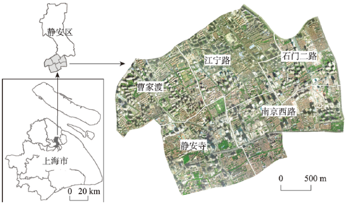
本文以上海市静安区五街道(与闸北区合并前的静安区范围)的应急避难所为例,阐述利用构建的方法框架实现城市应急避难所模拟选址的过程和结果。
上海市静安区在2015年底与闸北区合并之前,拥有5个街道(图2),并且和6个其他的区相邻。该区在合并前的总面积7.62 km2,有7.57 km2的陆地面积和0.05 km2的水域。作为上海最为中心的城区之一,静安区有一个中心商业区和一个宾馆区域。2010年底,静安区下属5个街道共有24.68万常住人口,人口密度为3.24人/km2。但是直到2015年底,静安区只有一个已建成的和一个在建的应急避难所。作为特大型城市的人口聚居区域,静安区亟需建立更多的避难所。建立新避难所的前期工作中,对避难所进行选址以及做空间评估是重要的环节。优化城市避难所的布局,有效的进行应急疏散的管理对于在自然和人为灾害中降低人员伤亡和经济损失具有关键性的意义。
图2 上海市静安区南部5个街道的地理位置
Fig. 2 Location of five southern subdistricts of Jing'an District, Shanghai, China
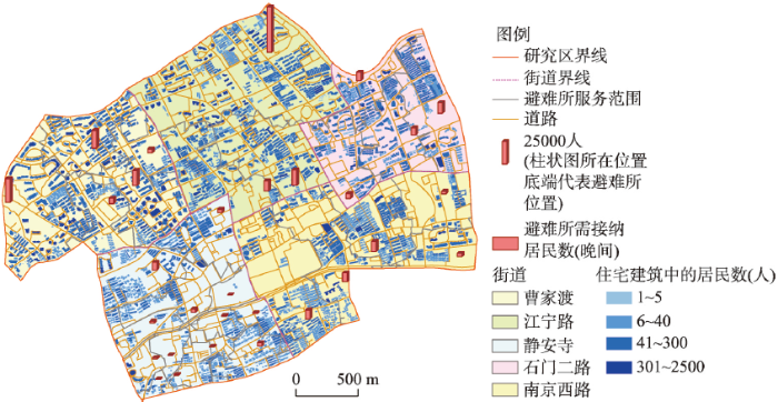
上海市静安区的土地利用数据基于2013年的空间分辨率为0.25 m的航拍影像解译获得。在2012年的《城市用地分类与规划建设用地标准GB50137-2011》和美国联邦应急管理局研发的HAZUS模型中的土地分类标准的基础上,构建了城市土地利用分类系统,并以此为依据完成静安区的土地利用分类解译工作。由于大型城市中心用地的稀缺性,要改变某种用地类型,新建应急避难所比较困难。而利用现有的某种用地,通过改造使其兼具避难所的功能的方法具有很好的应用价值。因此获取到土地利用数据后,将具备一定规模的娱乐康体设施用地、文化活动设施用地、教育科研用地、体育场馆用地、医疗卫生用地、绿地和广场用地等作为备选城市避难所。利用矢量线状道路图层(图3)生成道路网络数据集。利用住宅建筑图层、以居委会为统计单元的人口统计资料,以及静安区居委行政区划图为基础生成人口分布数据(图3)。
图3 上海市静安区的空间数据
Fig. 3 Spatial data of the study area of Jing'an District, Shanghai
由于真实情况下,应急疏散过程具有很高的复杂性和不确定性,难于对所有可能的情景进行模拟。因此在执行智能体模型模拟之前,需要做情景约束和预设一系列的参数。本案例研究中,假定政府智能体将每个避难所的服务范围约束在某个街道范围内。居民已经接受了防灾避灾演练,具备较强的灾时自救和互助能力。政府智能体另外还颁布规定:在应急疏散中,每个小于5岁的小孩和大于70岁的老年人都必须至少有一个成人照看。案例中,设定了重大灾害前的应急疏散避难情景。政府智能体对重大灾害发出预警,在第一时间组织居民有序的去往应急避难所,不考虑居民获得预警信息的时间差。避难所智能体从用地类型中选取绿地和广场作为备选避难所,加上上海市静安区内已有的避难所,总共30个。另外,避难所智能体还为每个避难所生成其服务范围(图3),统计哪些居民去往哪个避难所进行避难。居民智能体的参数设定基于实地考察和参考文献。式(4)中vB(m)、VB(m)和tmax flow根据不同的住宅建筑类型设定,TI设为20 s;式(5)中Dmax的值参照Roytman[34]提出的“房屋建筑消防安全标准原理”,设为6.25人/m2。
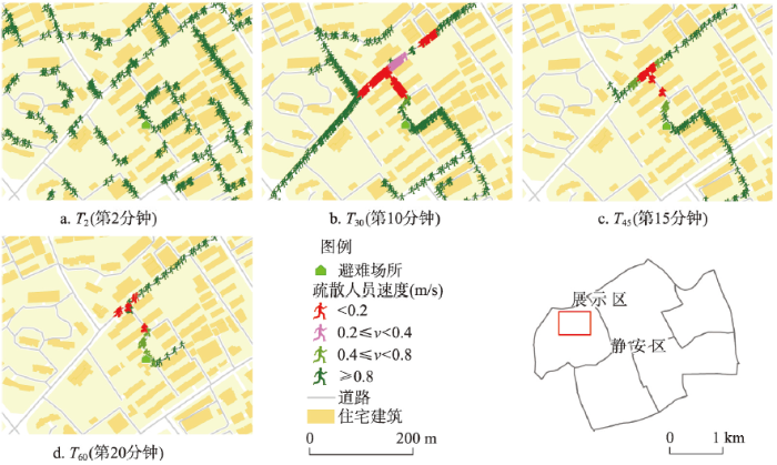
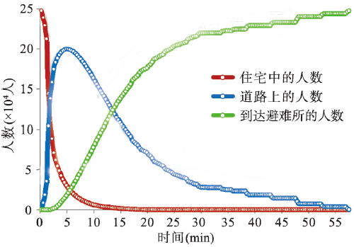
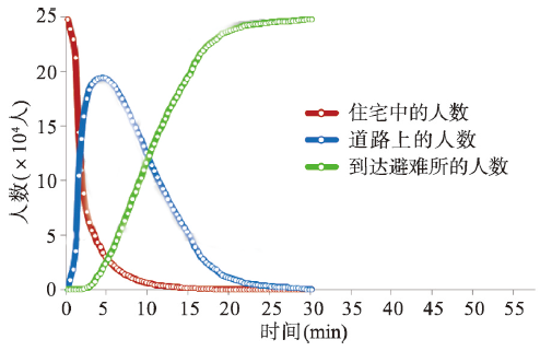
根据本文提出的方法框架,利用编写的模拟工具软件,根据时间步生成疏散模拟图层。图4展示了上海市静安区的样区范围内4个不同时间步对应的模拟图层。通过不同时间步的前后对比,可以看出居民的动态移动过程,拥挤状态可以通过人员行走速度的变化来监测。根据本次设定的情景,一共生成了172个疏散模拟图层,代表了在t172时间步,所有的居民都到达了避难所。因为时间间隔(TI)等于20 s,所以可以计算出总共的疏散时间为57.3 min。通过模拟图层的数据解析,可以获得每个居民的疏散时间。本文对仍然在住宅建筑中的居民、在道路上的居民(在疏散过程中)和已经到达避难所的居民进行统计(图5)。上述这3类居民的人数总和为上海市静安区的总居民数。建筑物中的居民数在疏散起始阶段大量减少,10 min后仅剩下2.59%。在23 min后,所有的居民都离开了住宅建筑,并沿着道路走向就近的避难所。道路上人数最多的时候超过了20万人,人数的高峰出现在开始疏散后的第5 min。对于到达避难所的居民人数来说,在前20 min,人数大致呈线性增长趋势;在20 min时,有超过71%的居民完成疏散过程到达避难所;但是在余下的37.3 min内,增长的趋势减缓。为了完成最后11%的居民的疏散避难,花费了超过30 min。最后5.8%的人员避难,用了近15 min。
图4 上海市静安区4个时间步对应的模拟图层
Fig. 4 Simulation layers in four different time steps of Jing'an District, Shanghai
图5 到达避难所的居民数、道路上(正在疏散)居民数和仍在住宅建筑中的居民数
Fig. 5 Number of persons arriving at shelters, persons on roads (in evacuation) and persons in residential buildings
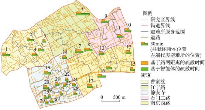
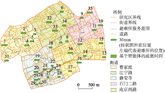
进一步分析和评估每个避难所的居民疏散时间,能够找出疏散时间成本上的空间不均衡性。传统的基于路网距离的疏散时间评估方法被用来和基于智能体的方法做比较。在基于路网距离的方法中,假定居民的平均行走速度为1.2 m/s,每个避难所的疏散时间是以其服务范围内所有住宅建筑到达该避难所的路网距离中的最大值除以平均行走速度得出。基于路网距离和基于智能体的总体疏散时间评估图如图6所示。图6中,棕黄色柱状图代表基于路网距离的总体疏散时间,绿色柱状图代表基于智能体方法的总体疏散时间。很明显,所有的基于智能体的时间估算都比基于路网距离的方法要长,前者被认为是更为合理的,这是因为道路上的人员拥挤情况,以及不同年龄人群的行走速度差异在疏散时间估算中是不可缺少的。避难所6的疏散时间最长,使得整个研究区的总疏散时间被延长了。即使该避难所能够容纳其服务范围内的49000多个居民,但是这些居民仍然要面对疏散避难时间过长的危险。为了解决这一问题,江宁路街道必需再新建应急避难所,使得该区域内的避难所容量和居民的疏散避难时间都能够满足规范要求。其余5个疏散时间超过30 min的避难所1、7、8、9和16都因为空间位置的原因,在时间上无法满足周边居民的避难需求。因此,有必要在它们的服务范围内再行选址新建避难所,从而缓解部分居民疏散避难时间过长的问题。
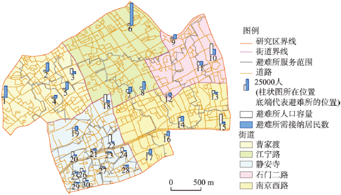
为帮助后续的选址决策,本文中根据土地利用解译获得的备选避难所的占地面积,和每个人员需占据的空间面积,计算获得了静安区每个备选避难所的容量(图7)。图7中白色柱状图显示了避难所的人口容量,蓝色柱状图标识了避难所需接纳的居民数,从两类柱状图的对比可以看出,上海市静安区的西北部、北部和东南部的一系列避难所的容量仍然不能满足居民的避难需要,必须进行扩容。只有静安寺街道的西南部、石门二路和南京西路街道的东部部分区域的避难所容量能够大致满足避难的需求。因此,静安区的应急避难所有必要进行扩建和新建。实际拟扩容的面积需根据后续选址新建避难所后,重新划定每个避难所的服务范围,并分析计算新的所需接纳居民数后确定。
疏散过程中,道路拥挤的情况不仅需要给予足够的重视,而且还非常有必要对此进行预警和管理。道路的拥挤状态会引起避难人员紧张、恐慌,发生无序的四散奔拓,造成意想不到的危险。本文中,以0.6 m/s的行走速度作为疏散过程中是否拥挤的阈值,对在不同道路路段上不同时间步内的居民行走速度进行模拟检测,来计算每个路段的拥挤时长。如果在时间tn,在某路段上人员的平均速度小于该阈值,那么这个路段将被判断为在该时间步内是拥挤的。对每个疏散模拟图层的每个路段,根据上述规则执行相同的操作,从而获取整个疏散过程中的道路路段的拥挤时间。
图6 基于路网距离和基于智能体方法的上海市静安区各避难所总疏散时间
Fig. 6 Road network distance based and agent-based total evacuation times of shelters of Jing'an District, Shanghai
图7 上海市静安区避难所人口容量和服务范围内需接纳居民数
Fig. 7 Population capacities and numbers of residents in service areas of shelters of Jing'an District, Shanghai
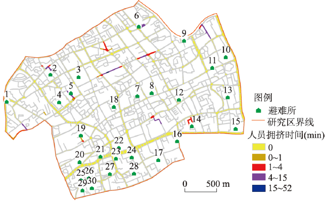
图8 上海市静安区标识道路中的拥挤路段:整个疏散过程中各个路段的拥挤时间
Fig. 8 Finding hotspots of road congestion: Congestion time of road segments in the evacuation process of Jing'an District, Shanghai
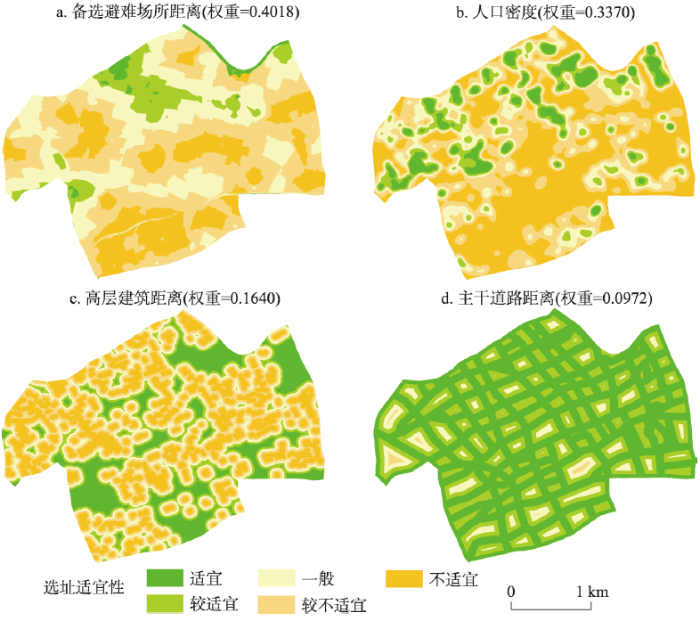
图9 多准则决策(AHP)中的评价因子图层及其权重
Fig. 9 Evaluation criteria layers and their weights in multi-criteria decision making (AHP)
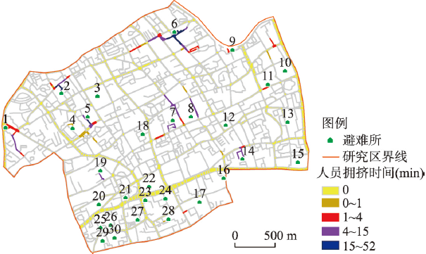
拥挤时间统计结果如图8所示。从图8可以看出,区域内多数道路路段没有出现拥挤的情况。大约只有4.6%的路段存在不同程度的人员拥挤。这些拥挤的路段主要集中在避难所1、2、5、6、7、8、9、11、14和19附近。拥挤最严重的情况出现在避难所2、5和6的周边。在这些路段上人员的疏散时间,都超过了15 min。特别是与避难所6相邻的路段,拥挤时间甚至达到了52 min。
道路拥挤情况的模拟和识别,以及对拥挤时间的测算和定级,能够帮助地方政府和相关的责任部门对应急疏散进行更好的决策管理。比如在拥挤高发路段利用广播提醒居民注意潜在的危险,或在拥挤区域部署管理人员进行有效疏导。更重要的是,为城市建设规划部门,提供必要的、合理的参考与建议。比如及早采取预警措施,扩建可能在城市应急避难中发生拥挤的道路路段或开辟新的道路,提高城市应对灾难的能力。
由于智能体模拟疏散过程中,不同的居民走出住宅建筑的次序具有一定的不确定性,因此研究中重复执行该模拟过程10次,并根据这10次的模拟结果做分析和探讨,获得如表1所示的决策方案。
表1 避难所相关规划决策方案示例
Tab. 1 Examples of decision-making scheme relative to planning of shelters
| 避难所 编号 | 所在 街道 | 服务范围内是否 新建避难所 | 是否拟 扩容 | 服务范围内是否进行道路拓宽 |
|---|---|---|---|---|
| 1 | 曹家渡 | 是 | 是 | 是 |
| 2 | 曹家渡 | 否 | 是 | 是 |
| 3 | 曹家渡 | 否 | 否 | 否 |
| 4 | 曹家渡 | 否 | 是 | 是 |
| 5 | 曹家渡 | 否 | 是 | 是 |
| 6 | 江宁路 | 是 | 否 | 是 |
| 7 | 江宁路 | 是 | 是 | 是 |
| 8 | 江宁路 | 是 | 是 | 是 |
| … | … | … | … | … |
| 30 | 静安寺 | 否 | 否 | 否 |
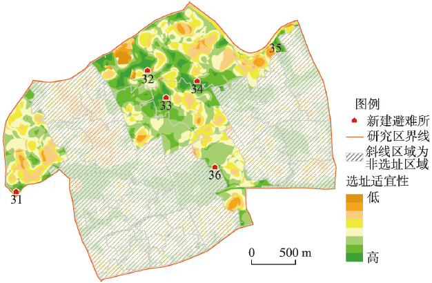
结合表1中的新建避难所要求,利用上海市静安区的基础空间数据作为评价因子,对新建避难所的空间选址适宜性进行评价。本文中,在上海市静安区选取了人口密度、备选避难所距离、高层建筑距离和主干道路距离作为评价因子。人口密度利用人口分布数据生成核密度图,人口密度越高,选址适宜性越高。备选避难所距离是指新建选址的位置离当前已经备选的避难所的距离。由于要保证避难资源分配的公平性,减小资源分配的重叠度,研究中设定距离越远适宜性越高。应急避难所的选址还应该与高层建筑保持一定的距离,因此离高层建筑越远,适宜性越高。为了提高可达性,避难所应尽量靠近主干道。4个评价因子均通过阈值划分为5个等级,分别以“1”至“5”五个数字赋值。4个因子的权重通过多准则决策(AHP)方法计算,并利用本文中的权重敏感性分析方法降低该方法的主观性,最终确定成对比较矩阵,生成的评价因子图层以及通过AHP方法计算后获得的因子权重如图9所示。将4个图层按因子权重进行叠加,生成避难所选址适宜性评价结果(图10)。在图10中,以高适宜性区域为选址范围,并根据静安区的土地利用布局现状和决策方案(表1)中需进行选址新建的空间范围,完成对新建避难所的选址。
图10 上海市静安区新建避难所的选址适宜性和选址结果
Fig. 10 Location-allocation suitability and location-allocation results of new shelters of Jing'an District, Shanghai
完成新建避难所的选址后,将新的避难所加入到备选避难所图层中,重新生成每个避难所的服务范围,并根据新的接纳居民数量为需要扩建的避难所扩容。对道路中存在人员拥挤情况的路段(图8)进行拓宽,生成拓宽后的道路网络图层。因为新建的避难所对周边的疏散居民具有分流作用,因此在路段拓宽时,可将周边是否有新建的避难所纳入考虑范畴。
图11 第二轮疏散模拟中,到达避难所的居民数、道路上(正在疏散)居民数和仍在住宅建筑中的居民数
Fig. 11 Number of persons arrived at shelters, persons on roads (in evacuation) and persons in residential buildings in the second round of evacuation simulation
将新的避难所图层与道路网络图层更新至方法框架中的空间数据里,并重新执行框架流程,完成第二轮的应急疏散模拟过程。以一次模拟为例,模拟过程中共生成了93个疏散模拟图层。上海市静安区的总疏散时间得到了有效的控制,从原先的57.3 min下降到了30.3 min,基本满足了所有居民能够在30 min内完成疏散避难的要求。本文再次对疏散过程中仍在住宅建筑中的居民、在道路上的居民(在疏散过程中)和已经到达避难所的居民进行统计(图11)。道路上人数的峰值还是出现在开始疏散后的第5 min。但是到达峰值后,道路上的人员数量下降的速率明显加快。在应急疏散20 min时,已有96.7%的居民完成了疏散,到达了避难所。而25 min时,仅有0.95%的居民还在去往避难所的途中。
第二轮疏散模拟结束后,对每个避难所再次执行居民疏散时间的评估,如图12所示。对比图6中的基于智能体方法的疏散时间,可以看出,原先疏散时间超过30 min的避难所6、7、8、9和16的疏散时间均减少到了30 min以内。19个避难所的人员疏散时间在20 min内,其中疏散时间最长的避难所1也被控制在了30.3 min。这一轮循环校验和优化,使避难所的空间布局达到了居民在应急疏散避难中的时间要求。
对新生成的应急疏散模拟结果进行道路拥挤情况的统计(图13),对比图8中的拥挤路段能够发现,原先存在拥挤的路段已经得到拥挤问题的解决或者很大程度的缓解。比如,避难所2、5、6、14、19拥挤程度都有所缓解,其中拥挤程度最高的避难所6周围的道路拥挤时间由原来的52 min下降到目前的8.6 min。另外,避难所1、7、8、9、11周围道路拥挤情况消失。但是,由于新建的避难所引导了一部分疏散人群,会在其附近的一些道路上产生新的人员拥挤情况。由图13可见,新建的6个避难所附近都产生了不同程度的道路拥挤情况。该问题可以依据本文的方法框架(图1),将存在拥挤的路段再拓宽,以更新的道路网络图层,进行新一轮的疏散模拟和循环校验来解决。
图12 基于智能体方法的上海市静安区第二轮各避难所总疏散时间
Fig. 12 Agent-based total evacuation times of shelters in the second round simulation of Jing'an District, Shanghai
图13 上海市静安区第二轮标识道路中的拥挤路段:整个疏散过程中各个路段的拥挤时间
Fig. 13 Finding hotspots of road congestion in the second round simulation: Congestion time of road segments in the evacuation process of Jing'an District, Shanghai
本文提出了一种基于智能体的居民疏散至城市应急避难所过程的模拟方法,进而能够支持避难所的空间选址和相关的规划决策。本文设计的方法框架中,政府智能体、避难所智能体和居民智能体组成的智能体模型始终贯穿整个过程,并通过这三种智能体之间的交互与演绎,实现了疏散过程的仿真模拟、避难所配置的评估、结合多准则决策方法的选址决策、空间配置结果的循环校验,实现最终应急避难所空间配置结果的生成。
通过应用上海市静安区5个街道的应急避难所空间配置案例,证明了该方法的可行性与有效性。研究中,除了已有避难所和初步选定的备选避难所外,通过应急疏散模拟和多准则决策方法的循环校验,最终在江宁路街道选定了3个新的应急避难所,在石门二路、曹家渡和南京西路街道各选定了1个新避难所,并确定了避难所扩容和周边道路的拓宽方案。经最后一轮的应急疏散模拟验证,得出了最终的避难所空间配置方案,能够使城市居民在30 min内完成疏散,并有效控制人员拥挤时间。
应急避难所的选址与配置不同于一般的城市设施选址,需要考虑到城市居民疏散的时间、疏散避难过程中的安全性、避难所的容量等因素。相比传统的选址方法,本文具有以下3点优势:① 能够通过应急疏散模拟直观地发现城市避难所配置上的不足,从而更好的指导避难所的空间选址和容量配置;② 相比传统的以路网距离来估算疏散时间的方法,不但能更精确的估算每个避难所接纳居民的时间,和整个上海市静安区总体疏散的时间,还能可视化地发现疏散道路上的拥挤路段,并标识出这些路段拥挤的时间。③ 通过多轮的应急疏散模拟和多准则决策方法,实现应急避难所空间配置的循环校验,获得更为可信和有效的避难所配置方案。
本文在应急疏散模拟和多准则决策方法的运用过程中都存在着一些不确定性:①多准则决策方法中,各个准则权重的赋值具有不确定性。为此,研究中采用了OAT方法实现准则权重的敏感性评估,来帮助决策人员更好地确定AHP成对比较矩阵中的元素值,以求形成合理的准则权重。② 应急疏散模拟中,城市居民的疏散过程具有不确定性。本文主要考虑的是不同居民走出住宅建筑过程中具有的不确定性,通过重复多次执行应急疏散模拟过程,以获得更加稳定的模拟结果。而真实情况下的应急疏散具有很高的不确定性,居民的行为、灾害发生时的道路条件改变等因素,都对应急疏散的过程造成影响。在今后的研究工作中,将对居民的行为做拓展研究和建模,并将由灾害造成的道路阻塞和损毁的风险性纳入到案例情景中,使该方法更趋于合理和完善。
此外,需要指出本文涉及的研究领域具有多学科融合的特点。其中,选址问题是运筹学中的经典问题;居民智能体包含人的复杂行为,需要心理学支持;避难所空间配置后的检验能通过统计学理论加强等。特别是统计学科中的空间抽样理论,与本文研究的空间选址方法具有共通性。比如,Rogerson等[12]为更好的测度通讯网络信号接收强度(RSSI)在空间上的分布,尝试在现有RSSI抽样样本点的基础上,选取更多的样本点,从而为道路上交通事故发生后的车辆求救系统的呼叫接通提供有效的评估。为了更好的在现有的样本点的基础上选取更理想的位置进行采样,该研究通过比较新增采样点后,克里金方差的平均下降程度,从而选定最优的样本点组合。为了解决更大数量样本点的选取工作,该研究还加入了动态贪婪算法,以提高模型的解算效率。这一典型的研究案例,说明了空间抽样领域的核心内容是如何在现有的抽样样本点的基础上,更优化的选取新的样本点。这与本文在现有的城市避难所空间布局的基础上,如何实现新的避难所选址具有共通性。
此外,近年来空间抽样越来越重视空间上的地理环境差异,将空间异质性纳入考虑范畴[13]。考虑空间异质性的空间分层抽样,一般先将抽样区域划分成若干个更为均质性的子区域,然后再分别为子区域设定抽样数量和方案,从而提高抽样位置选取的精度和效率。这一思路也恰与本文选址适宜性分析中,将整个区域分为不同适宜性级别的子区域很相似。鉴于空间统计学中,空间分层方法上的优势和空间抽样在抽样检验上的数学严谨性,在未来的研究工作中,将利用这方面的理论方法进一步加强本文选址适宜性分析和选址后的检验过程。在运筹学、心理学等学科的相关领域,也将尝试学科交叉运用与综合建模,从而更好地为城市避难设施的空间配置工作服务。
The authors have declared that no competing interests exist.
| [1] |
Locating temporary shelter areas after an earthquake: A case for Turkey. https://doi.org/10.1016/j.ejor.2014.11.035 URL [本文引用: 1] 摘要
In this study, we propose a mixed integer linear programming based methodology for selecting the location of temporary shelter sites. The mathematical model maximizes the minimum weight of open shelter areas while deciding on the location of shelter areas, the assigned population points to each open shelter area and controls the utilization of open shelter areas. We validate the mathematical model by generating a base case scenario using real data for Kartal, Istanbul, Turkey. Also, we perform a sensitivity analysis on the parameters of the mentioned mathematical model and discuss our findings. Lastly, we perform a case study using the data from the 2011 Van earthquake.
|
| [2] |
Decision support for urban shelter locations based on covering model. https://doi.org/10.1016/j.proeng.2012.08.011 URL [本文引用: 1] 摘要
Developing small towns is one important way to push on the urbanization, but the disaster threat is the severe hindrance to the healthy and rapid development of small towns. Compared with the advantages and disadvantages of the Location Set Covering Problem and the Maximum Covering Location Problem, the decision was produced for urban shelter locations in small and medium-sized cities. Firstly a qualitative and quantitative method of urban shelter location decision to distinguish uncovering requirement sites and unmet service need were used, and then an alternative plan for the decision was developed, at last through considering the feasibility of the plan, the most suitable scheme is determined in order to adapt to the different emergency service facilities deployment strategy. Considering the equity and efficiency of emergency rescue facility, this model integrates the Location Set Covering Problem with the Maximum Covering Location Problem, and with an example the paper discusses the solution approach of the model and some solution strategies. What's more, this model has fully taken the cost and benefit into consideration, which provides a feasible way of decision making for the developing city with budget shortfalls.
|
| [3] |
An overview of the design of disaster relief shelters. https://doi.org/10.1016/S2212-5671(14)01019-3 URL [本文引用: 1] 摘要
Disaster relief (DR) shelters play a vital role in large-scale disasters and are an important part of disaster response and recovery. DR shelters are used to provide private and secure places for people to live who have left or lost their usual accommodations as a result of some form of disaster. DR shelters not only provide immediate and short-term shelter for the victims of a disaster, but they also help them to recover from the trauma of a disaster as well as provide a base to start the process of rehabilitation. A review of the literature, case studies, guidance, and reports relating to the design of DR shelters indicates that their provision and performance are not currently as effective as they could be. A lack of adequate consideration with regard to climatic conditions, locally available materials and skills, cultural and social issues, delays, cost constraints, and poor location selection for DR shelters have each been identified as sources of poor performance contributing to an unacceptable standard of living. Moreover, there seems to be a lack of sufficient consideration with regard to the design of DR shelters for future storage and re-use. The principal aim of this research is to examine the extent to which environmental, economic, technical, and sociocultural criteria affect the provision and performance of DR shelters, and how such factors might be taken into account in the decision-making and design processes of such shelters.
|
| [4] |
A modified particle swarm optimization algorithm for optimal allocation of earthquake emergency shelters. https://doi.org/10.1080/13658816.2011.643802 URL Magsci [本文引用: 2] 摘要
Allocation for earthquake emergency shelters is a complicated geographic optimization problem because it involves multiple sites, strict constraints, and discrete feasible domain. Huge solution space makes the problem computationally intractable. Traditional brute-force methods can obtain exact optimal solutions. However, it is not sophisticated enough to solve the complex optimization problem with reasonable time especially in high-dimensional solution space. Artificial intelligent algorithms hold the promise of improving the effectiveness of location search. This article proposes a modified particle swarm optimization (PSO) algorithm to deal with the allocation problem of earthquake emergency shelter. A new discrete PSO and the feasibility-based rule are incorporated according to the discrete solution space and strict constraints. In addition, for enhancing search capability, simulated annealing (SA) algorithm is employed to escape from local optima. The modified algorithm has been applied to the allocation of earthquake emergency shelters in the Zhuguang Block of Guangzhou City, China. The experiments have shown that the algorithm can identify the number and locations of emergency shelters. The modified PSO algorithm shows a better performance than other hybrid algorithms presented in the article, and is an effective approach for the allocation problem of earthquake emergency shelters.
|
| [5] |
Computer solutions to minimum cover problems. https://doi.org/10.1287/opre.17.3.455 URL [本文引用: 1] 摘要
A covering problem may be stated as follows: Minimize$\sum_{j=1}^{j=n}c_{j}x_{j}$subject to the constraints$\sum_{j\epsilon J_{i}}x_{j}\geq 1$,$J_{i}\subseteq \{1,2,\cdots ,n\}$; xjintegers,$i=1,2,\cdots ,m$. An algorithm has been programmed on the IBM 7094 for solving such problems. For a given problem, it generates a set of independent 'locally-optimum' solutions. If p is the probability that any one solution is actually an optimum, then for n independently generated solutions we have a probability of 1-(1-p)nthat an optimal solution appears in the set generated. Computational experience indicates that this approach yields good results for large problems (up to m· n≤ 0.5× 10⁶).
|
| [6] |
A new heuristic for the capacitated vertex P-center problem. https://doi.org/10.1007/978-3-642-40643-0_29 URL [本文引用: 1] 摘要
A metaheuristic for the capacitated vertex p -center problem is presented. This is a well-known location problem that consists of placing p facilities and assigning customers to these in such a way that the largest distance between any customer and its associated facility is minimized. In addition, a capacity on demand for each facility is considered. The proposed metaheuristic framework integrates several components such as a greedy randomized adaptive procedure with biased sampling in its construction phase and iterated greedy with a variable neighborhood descent in its local search phase. The overall performance of the heuristic is numerically assessed on widely used benchmarks on location literature. The results indicate the proposed heuristic outperforms the best existing heuristic.
|
| [7] |
A parallel cooperative hybridization approach to the P-median problem. https://doi.org/10.1068/b38004 URL [本文引用: 1] 摘要
The p -median problem is difficult to solve and many heuristic methods have been developed. This paper discusses a new hybridization approach in which existing heuristics are used as 02experts’ in a problem-solving team where they cooperate by sharing their solutions with each other. This approach is demonstrated using two heuristics called the 02vertex substitution method’ and 02simulated annealing’. Five cooperation strategies are designed and implemented using an application program interface for parallel programming. Computational experiments show that the strategy named 02parallel consensus’ can significantly improve the quality of solutions found when compared with the original heuristics. The results also show significant speedups of the program in a multicore parallel computing environment. Keywords: p -median problem, cooperative hybrid heuristics, parallel computing, vertex substitution, simulated annealing, OpenMP
|
| [8] |
A hierarchical location model for public facility planning. https://doi.org/10.1016/j.ejor.2006.12.027 URL Magsci [本文引用: 1] 摘要
In this article, we present a discrete hierarchical location model for public facility planning. The main features of the model are: an accessibility maximization objective; several levels of demand and of facilities; a nested hierarchy of facilities (i.e. a facility of a given level can serve demand of equal and lower levels); maximum and minimum capacity constraints; and user-to-facility assignment constraints. The latter include single-assignment and closest-assignment constraints, as well as a new type of constraints called path-assignment constraints. Their purpose is to enforce some desirable properties for the spatial pattern of assignments. If they are not included, model solutions are difficult to interpret and to explain in a public facility planning context, therefore being less likely to be accepted by the users. The usefulness of the model is illustrated through a real-world application to school network planning.
|
| [9] |
Planar location and design of a new facility with inner and outer competition: an interval lexicographical-like solution procedure. https://doi.org/10.1007/s11067-006-9005-4 URL [本文引用: 1] 摘要
A chain has to decide the location and design for a single new facility in a region where a set of facilities already exists offering the same type of product. Some of the existing facilities belong to the chain and the others are competitors. Since competition comes from outside the chain, the maximization of the profit is the main objective of the chain鈥檚 owner. Customers are supposed to patronize all the facilities, the old and the new, proportionally to the attraction they feel for them. The entrance of the new facility may thus also have a detrimental effect on the market shares of the existing chain-owned facilities, and this cannibalization should be minimized as a secondary objective. This problem is formulated as a biobjective optimization problem, and a variant of the lexicographic method is proposed to generate certain efficient solutions. This requires solving two related optimization problems, both neither convex nor concave, for which a unified interval branch and bound method is developed. Computational experiments on randomly generated problems show the feasibility of the approach, while an application of the model with real data demonstrates its use for economical analysis.
|
| [10] |
Multi-period hub set covering problems with flexible radius: A modified genetic solution. https://doi.org/10.1016/j.apm.2015.09.064 URL [本文引用: 1] 摘要
Traditionally, in hub covering problems, it is assumed that the covering radius is an exogenous parameter which cannot be controlled by the decision maker. In many real-world cases, with a negligible increase in covering radius, considerable savings in hub establishment costs are possible. On the contrary, changes in problem parameters during the planning horizon cause the results of theoretical models to be impractical in real-world situations. This article proposes a mixed integer model for a multi-period single-allocation hub set covering problem in which the covering radius is a decision variable. The proposed model is validated through a real world case study. Also, due to the NP-Hardness of the problem a modified genetic algorithm (GA) is proposed for solving that. The proposed GA benefits from a dynamic stopping criteria and immigration operator. The performance of the proposed GA is compared with the original GA and imperialist competitive algorithm (ICA). Computational results corroborated efficiency of the proposed algorithm in achieving high-quality solutions in a reasonable time.
|
| [11] |
Chan F T S, Chung S H. A study of distribution center location based on the rough sets and interactive multi-objective fuzzy decision theory. Robotics & |
| [12] |
Optimal sampling design for variables with varying spatial importance. https://doi.org/10.1353/geo.2004.0006 URL [本文引用: 2] 摘要
It is often desirable to sample in those locations where uncertainty associated with a variable...
|
| [13] |
A review of spatial sampling. https://doi.org/10.1016/j.spasta.2012.08.001 URL [本文引用: 2] 摘要
The main aim of spatial sampling is to collect samples in 1-, 2- or 3-dimensional space. It is typically used to estimate the total or mean for a parameter in an area, to optimize parameter estimations for unsampled locations, or to predict the location of a movable object. Some objectives are for populations, representing the 鈥渉ere and now鈥, whereas other objectives concern superpopulations that generate the populations. Data to be collected are usually spatially autocorrelated and heterogeneous, whereas sampling is usually not repeatable. In various senses it is distinct from the assumption of independent and identically distributed (i.i.d.) data from a population in conventional sampling. The uncertainty for spatial sample estimation propagates along a chain from spatial variation in the stochastic field to sample distribution and statistical tools used to obtain an estimate. This uncertainty is measured using either a design-based or model-based method. Both methods can be used in population and superpopulation studies. An unbiased estimate with the lowest variance is thus a common goal in spatial sampling and inference. Reaching this objective can be addressed by sample allocation in an area to obtain a restricted objective function.
|
| [14] |
Emergency adaption of urban emergency shelter: Analytic hierarchy process-based assessment method. 城市应急避难所的应急适应能力: 基于层次分析法的评价方法 . |
| [15] |
Disaster management: hierarchical structuring criteria for selection and location of temporary shelters. https://doi.org/10.1007/s11069-014-1437-4 URL [本文引用: 1] 摘要
Humanitarian logistics refers to the processes and systems involving the mobilization of people, resources and expertize to help vulnerable communities affected by natural disasters and complex emergencies, reducing the loss of lives and relieving human suffering. With regard to disaster management, one of the most important tasks is decision making. The lack of criteria with respect to the selection and location of temporary shelters, for example, can lead to unforeseen factors, threatening the quality of the logistics operation as a whole. A decision-making process can be aided by several models such as multi-criteria models, which address problems whose objectives require a global and comprehensive view of the situation. Among the possible perspectives of analysis, there is the identification of criteria that are relevant to decision making. In that sense, this paper presents the criteria and important aspects that should be addressed by a multi-criteria model for risk management, specifically in regard to moving and temporary sheltering the population affected by a disaster. Qualitative and quantitative aspects were identified, summing up to ten criteria. These criteria and their sub-criteria were hierarchically structured.
|
| [16] |
A GIS-based model to determine site suitability of emergency evacuation shelters. https://doi.org/10.1111/j.1467-9671.2008.01097.x URL [本文引用: 1] 摘要
Abstract In recent years, the increase in the number of hurricanes and other costal hazards in the US pose a tremendous threat to the residents of coastal states. According to the National Hurricane Center, Florida is the most vulnerable coastal state to hurricanes. Mitigation policies have been formulated to reduce mortality and provide emergency services by evacuating people from the hazard zone. Many of these evacuees, particularly the elderly or lower income populations, rely on evacuation shelters for temporary housing. Because of the cost and limited use, evacuation shelters are almost exclusively dual use shelters where the primary purpose of the facility is for some other public function (e.g. school, hospital, etc.). In 2000, the estimated shortage of public shelter spaces in Florida was about 1.5 million. The purpose of this study was to rank the existing and candidate shelters (schools, colleges, churches and community centers) available in the state based on their site suitability. The research questions examined in this study include: (1) How many candidate shelters are located in physically suitable areas (e.g. not in a flood prone area, not near hazardous facilities, etc.)?; (2) How many existing shelters are located in physically un suitable areas, but in socially suitable areas (situated in areas with demand)?; (3) How many alternative existing and/or candidate shelters with high/very high physical suitability are located near physically un suitable existing shelters and thus, may be better choices for a shelter?; and (4) How many existing shelters located in physically un suitable areas are not near alternative existing and/or candidate shelters? A Geographic Information System-based suitability model integrating Weighted Linear Combination (WLC) with a Pass/Fail screening technique was implemented for the 17 counties of Southern Florida. It was found that 48% of the existing shelters are located in physically unsuitable areas. Out of all the candidate shelters, 57% are located in physically unsuitable areas. For 15 of the existing shelters in unsuitable locations, no alternative candidate or existing shelter with medium to high physical suitability exists within 10 miles (16.1 km).
|
| [17] |
Earthquake shelter location evaluation considering road structure. IEEE The 8th International Conference on Intelligent Systems Design and Applications. |
| [18] |
The application of TOPSIS method in selecting fixed seismic shelter for evacuation in cities. https://doi.org/10.1016/j.sepro.2011.10.061 URL [本文引用: 1] 摘要
Selecting appropriate fixed seismic shelters for evacuation is key to earthquake engineering in cities. The author establishes an evaluation system comprising 3 first-level indices and 9 second-level indices related to influential factors such as risk of hazard, location & size and rescue facilities. The indices are generated by use of AHP and entropy methods. Finally, fixed seismic shelters for evacuation are selected by applying TOPSIS method, which proves the applicability of this method.
|
| [19] |
Study on evaluation of earthquake evacuation capacity in village based on multi-level grey evaluation. |
| [20] |
Multi-objective genetic algorithms for cost-effective distributions of actuators and sensors in large structures. https://doi.org/10.1016/j.eswa.2012.01.070 URL Magsci [本文引用: 1] 摘要
This paper proposes a multi-objective genetic algorithm (MOGA) for optimal placements of control devices and sensors in seismically excited civil structures through the integration of an implicit redundant representation genetic algorithm with a strength Pareto evolutionary algorithm 2. Not only are the total number and locations of control devices and sensors optimized, but dynamic responses of structures are also minimized as objective functions in the multi-objective formulation, i.e., both cost and seismic response control performance are simultaneously considered in structural control system design. The linear quadratic Gaussian control algorithm, hydraulic actuators and accelerometers are used for synthesis of active structural control systems on large civil structures. Three and twenty-story benchmark building structures are considered to demonstrate the performance of the proposed MOGA. It is shown that the proposed algorithm is effective in developing optimal Pareto front curves for optimal placement of actuators and sensors in seismically excited large buildings such that the performance on dynamic responses is also satisfied.
|
| [21] |
Agent-based evacuation simulation for spatial allocation assessment of urban shelters .https://doi.org/10.1117/12.2209277 URL [本文引用: 1] 摘要
The construction of urban shelters is one of the most important work in urban planning and disaster prevention. The spatial allocation assessment is a fundamental pre-step for spatial location-allocation of urban shelters. This paper introduces a new method which makes use of agent-based technology to implement evacuation simulation so as to conduct dynamic spatial allocation assessment of urban shelters. The method can not only accomplish traditional geospatial evaluation for urban shelters, but also simulate the evacuation process of the residents to shelters. The advantage of utilizing this method lies into three aspects: (1) the evacuation time of each citizen from a residential building to the shelter can be estimated more reasonably; (2) the total evacuation time of all the residents in a region is able to be obtained; (3) the road congestions in evacuation in sheltering can be detected so as to take precautionary measures to prevent potential risks. In this study, three types of agents are designed: shelter agents, government agents and resident agents. Shelter agents select specified land uses as shelter candidates for different disasters. Government agents delimitate the service area of each shelter, in other words, regulate which shelter a person should take, in accordance with the administrative boundaries and road distance between the person's position and the location of the shelter. Resident agents have a series of attributes, such as ages, positions, walking speeds, and so on. They also have several behaviors, such as reducing speed when walking in the crowd, helping old people and children, and so on. Integrating these three types of agents which are correlated with each other, evacuation procedures can be simulated and dynamic allocation assessment of shelters will be achieved. A case study in Jing'an District, Shanghai, China, was conducted to demonstrate the feasibility of the method. A scenario of earthquake disaster which occurs in nighttime was set to simulate the evacuation process of the residents to the earthquake shelter candidates in the study area. The simulation results convinced that the proposed method can better evaluate the spatial configuration of urban shelter than traditional GIS methods. The method can help local decision-makers preferably handle shelter planning and emergency evacuation management problems. It can also be extended to conduct similar assessment work in other urban regions for different kinds of shelters.
|
| [22] |
A review of the methodologies used in the computer simulation of evacuation from the built environment. https://doi.org/10.1016/S0360-1323(98)00057-2 URL [本文引用: 1] 摘要
Computer based analysis of evacuation can be performed using one of three different approaches, namely optimisation, simulation or risk assessment. Furthermore, within each approach different means of representing the enclosure, the population, and the behaviour of the population are possible. The myriad of approaches which are available has led to the development of some 22 different evacuation models. This article attempts to describe each of the modelling approaches adopted and critically review the inherent capabilities of each approach. The review is based on available published literature.
|
| [23] |
EMBLEM2: An empirically based large scale evacuation time estimate model. https://doi.org/10.1016/j.tra.2007.06.014 URL [本文引用: 1] 摘要
This article describes a simple, rapid method for calculating evacuation time estimates (ETEs) that is compatible with research findings about evacuees鈥 behavior in hurricanes. This revision of an earlier version of the empirically based large scale evacuation time estimate method (EMBLEM) uses empirical data derived from behavioral surveys and allows local emergency managers to calculate ETEs by specifying four evacuation route system parameters, 16 behavioral parameters, and five evacuation scope/timing parameters. EMBLEM2 is implemented within a menu-driven evacuation management decision support system (EMDSS) that local emergency managers can use to calculate ETEs and conduct sensitivity analyses to examine the effects of plausible variation in the parameters. In addition, they can run EMDSS in real time (less than 10聽min of run time) to recalculate ETEs while monitoring an approaching hurricane. The article provides an example using EMDSS to calculate ETEs for San Patricio County Texas and discusses directions for further improvements of the model.
|
| [24] |
GIS: Agent-based modeling and evaluation of an earthquake-stricken area with a case study in Tehran, Iran. https://doi.org/10.1007/s11069-013-0784-x URL Magsci [本文引用: 1] 摘要
Although many researchers have attempted to prevent or mitigate damages, estimate vulnerabilities and control natural catastrophes, an important phase of disaster management that has received less attention is the challenge of managing people and resources directly after an incident. Because earthquakes can be one of the most disastrous events, especially in Iran, the purpose of this article is to develop an easy-to-use multi-agent simulation and modeling environment for the assessment of different disaster management scenarios as measured in terms of saving additional lives. The earthquake-induced damages to buildings, streets and citizens are the inputs to the proposed model. Five mobile agent types: citizen, paramedic, street-opener, police and robber; one stationary agent type: gas valve; and five inactive agent types: building, street, shelter, hospital and fire station form the context of the model. Disaster managers are provided with customizable settings for the number and attributes of the agents in the user interface and can assess various statistical and visual results to determine the optimal number and characteristics of the agents as well as evaluate the effectiveness of the location of shelters. To simulate the extent of a calamity, this model is tested on a small region in Tehran, Iran. The agents are created and input to the model automatically via vector GIS data layers and the entire model is vector-based. A comparison between the results of two different scenarios highlights that increasing the number of street-openers and paramedics would not create the desired improvement as long as these agents are focused on fire stations and hospitals. Additionally, the impact of street blockages is significant after an earthquake, and therefore, the potential capacity of the street-openers demonstrated in the simulations points to the necessity of retrofitting buildings and widening streets before an earthquake occurs.
|
| [25] |
Evaluation of resident evacuations in urban rainstorm waterlogging disasters based on scenario simulation: Daoli District (Harbin, China) as an example. https://doi.org/10.3390/ijerph111009964 URL PMID: 25264676 [本文引用: 1] 摘要
With the acceleration of urbanization, waterlogging has become an increasingly serious issue. Road waterlogging has a great influence on residents’ travel and traffic safety. Thus, evaluation of residents’ travel difficulties caused by rainstorm waterlogging disasters is of great significance for their travel safety and emergency shelter needs. This study investigated urban rainstorm waterlogging disasters, evaluating the impact of the evolution of such disasters’ evolution on residents’ evacuation, using Daoli District (Harbin, China) as the research demonstration area to perform empirical research using a combination of scenario simulations, questionnaires, GIS spatial technology analysis and a hydrodynamics method to establish an urban rainstorm waterlogging numerical simulation model. The results show that under the conditions of a 10-year frequency rainstorm, there are three street sections in the study area with a high difficulty index, five street sections with medium difficulty index and the index is low at other districts, while under the conditions of a 50-year frequency rainstorm, there are five street sections with a high difficulty index, nine street sections with a medium difficulty index and the other districts all have a low index. These research results can help set the foundation for further small-scale urban rainstorm waterlogging disaster scenario simulations and emergency shelter planning as well as forecasting and warning, and provide a brand-new thought and research method for research on residents’ safe travel.
|
| [26] |
Simulating dynamical features of escape panic. https://doi.org/10.1038/35035023 URL PMID: 11028994 [本文引用: 1] 摘要
Abstract One of the most disastrous forms of collective human behaviour is the kind of crowd stampede induced by panic, often leading to fatalities as people are crushed or trampled. Sometimes this behaviour is triggered in life-threatening situations such as fires in crowded buildings; at other times, stampedes can arise during the rush for seats or seemingly without cause. Although engineers are finding ways to alleviate the scale of such disasters, their frequency seems to be increasing with the number and size of mass events. But systematic studies of panic behaviour and quantitative theories capable of predicting such crowd dynamics are rare. Here we use a model of pedestrian behaviour to investigate the mechanisms of (and preconditions for) panic and jamming by uncoordinated motion in crowds. Our simulations suggest practical ways to prevent dangerous crowd pressures. Moreover, we find an optimal strategy for escape from a smoke-filled room, involving a mixture of individualistic behaviour and collective 'herding' instinct.
|
| [27] |
Multi-agent simulation for crisis management. https://doi.org/10.1109/KMN.2002.1115175 URL [本文引用: 1] 摘要
Traditional crowd simulators are based on a simple numerical analysis of inputs such as the positions of people and structures; they do not consider leadership. Since leaders (in terms of evacuations) are present in many real-world situations, the validity of evacuation simulations can be increased through their introduction. We assess the results of a real-world evacuation experiment to develop more realistic scenarios for simulation. The simulations produced by the improved scenarios are found to closely mimic the experimental results. This work shows that scenario-based agent systems such as FlatWalk and FreeWalk offer excellent promise in simulating evacuations more realistically.
|
| [28] |
Microscopic simulation of pedestrian crowd motion. Pedestrian and Evacuation Dynamics, |
| [29] |
Development of simulation system for the disaster evacuation based on multi-agent model using GIS. https://doi.org/10.1016/S1007-0214(08)70173-1 URL [本文引用: 1] 摘要
This paper presents a simulation system for the disaster evacuation based on multi-agent model considering geographical information. This system consists of three parts, the modeling for the land and buildings using GIS data, the analysis of disaster evacuation using multi-agent model, and the visualization for the numerical results using the virtual reality technique. By introducing the numerical solver of the natural disaster to the present system, it is possible to evaluate not only the damage of structure but also the damage of human being. Furthermore, it is possible to investigate the appropriate evacuation route by the simulation. The Dijkstra algorithm is used to obtain shortest route to the refuge. In addition, the visualization using virtual reality technique is curried out to understand the feeling of refugee. The present system is applied to the evacuation analysis by the flood flow in urban area and is shown to be a useful tool to investigate the damage by natural disasters.
|
| [30] |
Urban emergency evacuation plans based on GIS and multi-agent systems.
构建了基于地理信息系统(GIS)和multi-agent系统的城市应急疏散仿真框架。该 仿真平台基于Repast仿真平台开发,利用Open Map组件读取GIS道路网络数据,作为人员疏散的地理环境。构建了人员和避难空间的agent模型,定义人员的避难空间和路径选择等主观决策行为规则, 并通过基于网络的交通流模型模拟人群在GIS路网上的运动。以中国某城市路网数据为基础,利用该仿真平台研究了城市应急疏散中人员对避难场所的选择规律以 及信息发布对疏散结果的影响。仿真结果表明:在疏散过程中加强有关避难空间信息的发布可缩短总体的疏散时间。
基于GIS和Multi-Agent的城市应急疏散 .
构建了基于地理信息系统(GIS)和multi-agent系统的城市应急疏散仿真框架。该 仿真平台基于Repast仿真平台开发,利用Open Map组件读取GIS道路网络数据,作为人员疏散的地理环境。构建了人员和避难空间的agent模型,定义人员的避难空间和路径选择等主观决策行为规则, 并通过基于网络的交通流模型模拟人群在GIS路网上的运动。以中国某城市路网数据为基础,利用该仿真平台研究了城市应急疏散中人员对避难场所的选择规律以 及信息发布对疏散结果的影响。仿真结果表明:在疏散过程中加强有关避难空间信息的发布可缩短总体的疏散时间。
|
| [31] |
Evaluation of small-area population estimation using LiDAR, Landsat TM and parcel data. |
| [32] |
Assessing fine-spatial-resolution remote sensing for small-area population estimation. https://doi.org/10.1080/01431161.2010.496800 URL [本文引用: 1] 摘要
Not Available
|
| [33] |
The spatial framework for weight sensitivity analysis in AHP-based multi-criteria decision making. https://doi.org/10.1016/j.envsoft.2013.06.010 URL [本文引用: 1] 摘要
Criteria weights determined from pairwise comparisons are often the greatest contributor to the uncertainties in the AHP-based multi-criteria decision making (MCDM). During an MCDM process, the weights can be changed directly by adjusting the output from a pairwise comparison matrix, or indirectly by recalculating the matrix after varying its input. Corresponding weight sensitivity on multi-criteria evaluation results is generally difficult to be quantitatively assessed and spatially visualized. This study developed a unique methodology which extends the AHP-SA model proposed by Chen etal. (2010) to a more comprehensive framework to analyze weight sensitivity caused by both direct and indirect weight changes using the one-at-a-time (OAT) technique. With increased efficiency, improved flexibility and enhanced visualization capability, the spatial framework was developed as AHP-SA2 within a GIS platform. A case study with in-depth discussion is provided to demonstrate the new toolset. It assists stakeholders and researchers with better understanding of weight sensitivity for characterising, reporting and minimising uncertainty in the AHP-based spatial MCDM.
|
| [34] |
Principles of Fire Safety Standards for Building Constructions. |

/
| 〈 |
|
〉 |