刘博一
LIU Boyi
通讯作者:
收稿日期: 2017-01-3
修回日期: 2017-03-4
网络出版日期: 2017-08-07
版权声明: 2017 《地理学报》编辑部 本文是开放获取期刊文献,在以下情况下可以自由使用:学术研究、学术交流、科研教学等,但不允许用于商业目的.
基金资助:
作者简介:
作者简介:刘博一(1993-), 男, 湖南湘潭人, 硕士研究生, 研究方向为河流地貌学。E-mail: liuby.14s@igsnrr.ac.cn
展开
摘要
河间湿地是网状河流体系中与多河道系统同等重要的地貌单元,其特征和发育程度与河道系统共同决定着网状河流的特性。本文以黄河玛曲网状河段作为研究对象,利用高分辨率Google Earth影像对研究河段河道与河间湿地等微地貌单元进行提取,利用湿地面积与湿地数对河间湿地的组成进行了分析,利用河间湿地面积占比、岸线密度、分汊点密度3个地貌参数,对河间湿地群体(河间湿地与分支河道特定组合体)的平面形态及多河道发育程度进行了研究。结果表明,河间湿地个体以中小型的为主,河间湿地群体则以大型和巨型的为主。河间湿地群体的发育程度与河间湿地群体面积(Su)明显相关,河间湿地面积占比(P)随Su的增大而增大,P值70%是河间湿地发育成熟的指标,而P值80%基本是河间湿地发育的上限值,此时河间湿地与分支河道基本达到动态平衡态。岸线密度、分汊点密度随Su的增加呈减小趋势,这种变化主要是由于不同大小河间湿地群体中河道发育过程差异导致。黄河玛曲段河间湿地群体的形成在于弯曲主河道的主导作用、地形限制因素削弱导致的河道带的发育,以及植被维护的河岸使得河间湿地群体得以较长时间保存。
关键词:
Abstract
Interchannel wetlands as well as multiple channels are crucial geomorphologic units in an anastomosing river system. Planform characteristics and developing level of interchannel wetlands and multiple channels have effect on anastomosing rivers. To understand the role that interchannel wetlands play in the development of the anastomosing river, a study was carried out at the Maqu reach of the Yellow River, a gravel-bed anastomosing river characterized by highly developed interchannel wetlands and anabranches. Geomorphologic units in the study reach were extracted from high resolution satellite imagery in Google Earth, size distribution of interchannel wetlands and interchannel wetland clusters (special combination of interchannel wetlands and anabranches) were investigated, and geomorphologic parameters including ratio of interchannel wetland area to interchannel wetland cluster area (P), shoreline density (Dl) and node density (Dn) were used to examine planform characteristics of interchannel wetland clusters and the development level of multiple channels in the study reach. The results suggest that interchannel wetlands with small or medium size and interchannel wetland clusters with large or mega size are more common in the study reach. The area of interchannel wetland cluster (Su) is highly related to other geomorphologic parameters, P increases with the increase of Su, with 80% of P value being basically the upper limit, indicating that the development of interchannel wetlands and anabranches in an interchannel wetland cluster has entered a equilibrium stage. In contrast, Dl and Dn show a tendency to decrease with the increase of Su due to evolution processes diversity in interchannel wetland clusters with different sizes. There are three main reasons for the formation of interchannel wetland clusters: stream power diversity caused by the meadering principal channel; development of river corridor due to the weakening of geologic structure control; and high stability of interchannel wetlands due to conservation by shoreline vegetation.
Keywords:
河间湿地(岛屿)或河漫滩分隔形成的稳定的多河道体系是网状河区别于其它河型最主要的特征[1]。网状河多河道的平面形态与顺直河道,弯曲河道有明显差异[2],而分隔河道的稳定的河间湿地(岛屿)或河漫滩则是其与辫状河的最大区别[3-5]。近年来,随着网状河作为一种独立河型被识别出来,其沉积特征[6-8]、河流水动力特征[9-12]、多河道形成过程[13-17]及其维持机制[18-19]也得到了更广泛研究。河道加积导致的冲决作用被认为是网状河多河道形成的主要原因[18],相对频繁的冲决作用以及相对较慢的河道废弃使得稳定的多河道得以维持[17]。对于网状河河道平面形态特征的研究最早源于区分网状河型的需要,弯曲度、辫状指数[3, 20]、辫状参数[21]以及辫状比率[22]都被用来描述网状河的平面形态特征。但是,这些源于对顺直河道、弯曲河道以及辫状河道形态特征进行描述的定量参数并不能总是很好地表征网状河多河道以及河间湿地的特征。网状河中不同河道可能展现为顺直或弯曲形态[8],单一的弯曲度不能体现网状河多河道的特征,而辫状指数、辫状参数以及辫状比率则忽略了河间湿地与河道面积上的特征。
河间湿地是网状河流体系中与多河道系统同等重要的地貌单元,其特征和发育程度与河道系统共同决定着网状河流的特性。在其它多河道河型的研究中,有学者利用历史地图以及航片提取河间湿地(岛屿)与洲滩的平面形态特征[23-24],进而分析了其形成、发育[25-26]以及动态变化过程[27-30]。河间湿地的发育与河道的发育是密不可分的。多河道形成的途径主要有两种方式,一是冲决作用切割河间湿地形成新河道[13],二是洲滩在植被作用下稳定化,进而形成河间湿地,分隔原河道,产生新河道[19]。两种河道发育方式都伴随着河间湿地的演化。
黄河玛曲段由于存在包括网状河在内的多河型的转换现象,受到了研究者的重视[31-35],其中河床比降[32]、支流汇入[33]、河谷构造[34]以及水沙和植被条件[35]在河型转化过程中都起到了重要作用。而与此相比黄河玛曲段砾质网状河中的河间湿地发育的独特性相对受到了忽略。该河段中对河道起分隔作用的主要是广泛发育的在汛期也能够出露的河间湿地,位置相邻、发育上具有相似性的一系列河间湿地常以河间湿地群体的形式出现。由于上下游河型的转化,网状河段内河道与河间湿地的发育程度也存在明显差异。因而本文选择了黄河玛曲段砾质网状河作为研究对象,利用高分辨率Google Earth影像提取了河道、河间湿地以及河间湿地群体等微地貌单元。选择面积和湿地数量作为衡量河间湿地群体规模特征的地貌参数,选择河间湿地面积占比[27]、岸线密度[36]与分汊点密度[37]作为衡量河间湿地群体发育程度的地貌参数,对该砾质网状河的河间湿地及其群体的平面形态特征、多河道发育程度进行研究。该研究有助于深入认识砾质网状河流多河道体系与河间湿地体系的组合模式,为揭示砾质网状河流演变机制而提供基本范例。
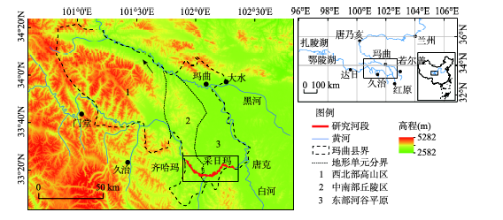
研究区位于甘肃省西南部的玛曲县,地处青藏高原东端的甘、青、川三省区交界处[38]。气候类型属高寒湿润型气候,年均降水量为564 mm,年均气温1.1 ℃[39]。境内大面积分布着高寒草原,高寒草甸草原以及沼泽类草原[40]。玛曲全县地貌可分为西北部高山区、中南部丘陵区和东部河谷平原三大区,阿尼玛卿山由西向东横贯全县中部[41]。黄河玛曲段干流围绕阿尼玛卿山东段,发生了180°大转弯,形成“U”型的黄河第一湾[31-33]。本文研究河段选择的砾质网状河段位于黄河第一湾的湾顶,黄河干流自甘肃省甘南藏族自治州玛曲县齐哈玛乡智卡至四川省阿坝藏族自治州若尔盖县沃琼公玛之间的河段(图1),长约65 km。河段内稳定的多河道体系与河间湿地广泛发育,形成了典型的网状河。该河段位于中南部丘陵与东部河谷平原的过度区域;上游河段为峡谷限制的弯曲河道,下游向单一的弯曲河道转变[33]。河岸植被以区域典型的亚高山草甸草原为主,而河间湿地则主要发育了灌木林地[39]。从沉积物来看,河岸及河间地以泥质和粉砂质为主,而河床则主要是砾石,粒度一般为4~7 cm[31]。根据黄河水文年鉴玛曲水文站的流量数据可知,玛曲河段12月-次年4月为枯水期,其中2月月均流量最小为113.72 m3/s;5月-11月为丰水期,洪峰流量主要出现在7月与9月,月均流量分别为1046.74 m3/s、955.19 m3/s。除1981年9月出现4320 m3/s的极端峰值流量外,峰值流量在7月和9月分别可达2670 m3/s、2870 m3/s。
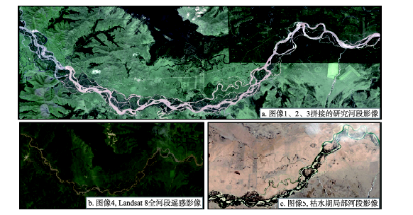
水文数据来源于黄河水文年鉴,时间序列为1959-1989年和2008-2013年。用于地貌单元提取的高分辨率遥感数据来源于Google Earth中GeoEye-1(GE01)以及Worldview-2(WV02)的遥感图像,通过谷歌卫星地图下载器[42]进行下载,分辨率为0.6 m。研究区域遥感影像(图2a)由两颗卫星分在3个时段获取,图像获取时间、覆盖河段、获取图像时的日平均流量等列于表1(图像1、2、3)。图像1获取时下游玛曲水文站的日平均流量为627 m³/s,远低于2011年峰值流量1860 m³/s,是洪峰过后的遥感影像;图像2和图像3获取时下游玛曲水文站的日平均流量分别为1640 m³/s、1920 m³/s,此时接近2013年峰值流量1930 m³/s。考虑到网状河型相对稳定的河道形态,短时间平面形态变化小,受到流量影响也较小,认为通过3幅图像拼接而成的影像能够有效反映该研究河段平面形态特征。
将遥感影像投影至横轴墨卡托北纬48带投影(UTM 48N)、WGS84基准面,在ArcGIS平台中以1:1000~1:2000的比例尺进行目视解译。河道与河间湿地的边界利用植被边界进行提取。研究区提取的湿地植被覆盖几乎都超过90%以上,远高于Zanoni[27]的认定标准,即植被面积覆盖> 75%。将矢量化的河道与河间湿地边界与地理空间数据云(http://www.gscloud.cn/)下载的2013年7月23日Landsat8全河段遥感影像(图2b)以及局部河段2011年3月8日枯水期高分辨率Google Earth遥感影像(图2c)的实际植被边界进行比较,发现其吻合度高,获取条件列于表1(图像4、5)。因而认为提取出的河道边界未受到遥感图像获取的时间以及流量条件的显著影响,能够有效反映网状河的平面形态特征。
表1 遥感图像获取条件
Tab. 1 Satellite imagery information
| 图像 | 卫星 | 获取日期 | 覆盖河段(km) | 流量(m³/s) |
|---|---|---|---|---|
| 1 | WV02 | 2011.08.27 | 0~13.34 | 627 |
| 2 | GE01 | 2013.07.29 | 13.41~45.18 | 1640 |
| 3 | GE01 | 2013.08.01 | 45.18~64.81 | 1920 |
| 4 | Landsat8 | 2013.07.23 | 0~64.81 | 1610 |
| 5 | WV02 | 2011.03.08 | 25.25~59.81 | 113 |
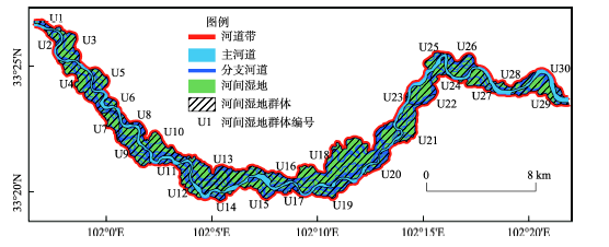
为了对研究河段形态特征进行分析,首先需要对其典型微地貌单元进行定义并且选取合适的表达参数。黄河玛曲网状河段的微地貌单元主要有河道带、主河道、分支河道、河间湿地以及河间湿地群体。其具体定义如表2所示,分布如图3所示。
表2 网状河主要微地貌单元
Tab. 2 Definition of micro geomorphologic units of an anastomising river
| 微地貌单元 | 定义 |
|---|---|
| 河道带 | 网状河中所有河道发育的范围,河道体系最外侧河道及其之间所有河道与河间湿地的集合 |
| 主河道 | 网状河中,常年有活动水流,一般情况下为河道体系中最宽的河道 |
| 分支河道 | 网状河中主河道以外的所有河道 |
| 河间湿地(岛屿) | 汛期能够出露的由植被覆盖的河道间高地 |
| 河间湿地群体 | 位置相邻,发育上具有连续性的河间湿地与分割这些河间湿地的分支河道的群体 |
在河道带、主河道和分支河道进行定义时主要参照了Rice等[43]对于河道等级的划分。主河道是水沙输移最主要的河道,而其他河道在本文中都被划分为分支河道,包括次级河道、季节性分汊河道以及滩上河道。对河间湿地进行定义时主要参照了Gurnell等[44]对建成岛屿(established island)的定义,包括植被固定洲滩形成的湿地,以及从泛滥平原上切割形成的泛滥平原切割岛。而对于河间湿地群体的划分主要参照了Rice等[43]对复合洲滩(compound bar)的定义,区别在于复合洲滩是一个连续的滩地,洲滩上有不同程度的植被覆盖,滩上河道和裸露滩地也是其重要组成。而本文中所说的河间湿地群体则是一系列河间湿地以及分支河道组成,其中湿地是最主要的组成部分,植被覆盖度高。枯水期出露的滩地在网状河中相对较少,对河道没有起到有效的分隔作用,在本文中被认为是河道的一部分。不同河间湿地群体由一级分支河道与部分次级分支河道分隔而成。其中一级分支河道为由主河道流出又汇入主河道的分支河道,次级分支河道为由一级分支河道流出(汇入主河道或者一级分支河道)的分支河道。
面积和数量特征是河间湿地以及河间湿地群体在平面形态上最基本的特征,因而本文选用河间湿地群体面积Su,以及河间湿地群体湿地数I作为衡量河间湿地群体规模特征的地貌参数。以河间湿地面积占比P、岸线密度Dl和分汊点密度Dn来描述河间湿地群体的发育程度特征。
河间湿地面积占比P,表示河间湿地群体中河间湿地面积的占比(%),计算公式为:
式中:Si表示河间湿地群体中所有河间湿地的总面积;Su表示河间湿地群体的总面积。
岸线密度Dl,单位河间湿地群体中湿地岸线的长度(km/km2),岸线长度一方面反映河间湿地的周长,另一方面可间接反映分支河道的长度。计算公式为:
式中:Li表示河间湿地群体中所有河间湿地的岸线总长。
分汊点密度Dn,单位面积河间湿地群体中分汊点的个数(个/km2),分汊点密度实际上反映的是分支河道的数量特征。计算公式为:
式中:N表示河间湿地群体中所有汊道分汊点数,包括河道分汊点及汊道汇合点,参照了Bertoldi等[37]所说的节点(node)。
从网状河的整体平面形态结构来看,网状河由主河道与由主河道分隔的一系列河间湿地群体组成。除极少数独立介于主河道范围内的小微型河间湿地外,研究河段的河间湿地主要集中分布在30个河间湿地群体中,沿程依次命名为U1, U2, ……, U30,其分布如图3所示,地貌参数如表3所示。
表3 河间湿地群体的地貌参数
Tab. 3 Geomorphologic parameters used in the assessment for the development of interchannel wetlands clusters
| 名称 | 面积 Su (hm2) | 湿地数 I (个) | 河间湿地面积占比P (%) | 岸线长度 Li (km) | 岸线密度 Dl (km/km2) | 分汊点个数 N (个) | 分汊点密度 Dn (个/km2) |
|---|---|---|---|---|---|---|---|
| U1 | 28.58 | 5 | 44.89 | 4.32 | 15.13 | 7 | 24.49 |
| U2 | 63.51 | 16 | 65.40 | 8.08 | 12.72 | 33 | 51.96 |
| U3 | 250.27 | 22 | 77.32 | 19.50 | 7.79 | 41 | 16.38 |
| U4 | 404.15 | 47 | 73.51 | 43.70 | 10.81 | 83 | 20.54 |
| U5 | 136.88 | 17 | 74.15 | 14.73 | 10.76 | 29 | 21.19 |
| U6 | 44.21 | 15 | 66.02 | 6.93 | 15.67 | 24 | 54.29 |
| U7 | 128.55 | 16 | 81.96 | 13.62 | 10.59 | 28 | 21.78 |
| U8 | 25.31 | 9 | 37.56 | 3.94 | 15.58 | 12 | 47.42 |
| U9 | 345.31 | 53 | 75.80 | 39.65 | 11.48 | 65 | 18.82 |
| U10 | 331.36 | 44 | 71.27 | 32.82 | 9.90 | 64 | 19.31 |
| U11 | 27.77 | 8 | 40.83 | 3.64 | 13.12 | 11 | 39.61 |
| U12 | 163.57 | 28 | 73.58 | 21.67 | 13.25 | 36 | 22.01 |
| U13 | 672.94 | 85 | 79.12 | 71.11 | 10.57 | 143 | 21.25 |
| U14 | 54.45 | 14 | 50.81 | 7.75 | 14.23 | 28 | 51.42 |
| U15 | 170.26 | 27 | 74.86 | 17.73 | 10.41 | 31 | 18.21 |
| U16 | 119.13 | 15 | 70.07 | 13.97 | 11.73 | 16 | 13.43 |
| U17 | 67.94 | 20 | 50.52 | 10.00 | 14.72 | 31 | 45.63 |
| U18 | 1336.17 | 131 | 79.24 | 110.94 | 8.30 | 202 | 15.12 |
| U19 | 177.93 | 48 | 63.95 | 24.47 | 13.75 | 56 | 31.47 |
| U20 | 95.34 | 41 | 57.09 | 17.20 | 18.04 | 63 | 66.08 |
| U21 | 321.44 | 54 | 78.85 | 35.77 | 11.13 | 67 | 20.84 |
| U22 | 239.77 | 12 | 73.98 | 14.48 | 6.04 | 15 | 6.26 |
| U23 | 6.46 | 2 | 33.25 | 0.82 | 12.66 | 3 | 46.47 |
| U24 | 96.14 | 13 | 78.33 | 11.31 | 11.76 | 21 | 21.84 |
| U25 | 70.64 | 4 | 71.70 | 5.92 | 8.37 | 7 | 9.91 |
| U26 | 243.44 | 18 | 71.57 | 22.62 | 9.29 | 32 | 13.15 |
| U27 | 183.42 | 26 | 83.21 | 18.86 | 10.28 | 45 | 24.53 |
| U28 | 114.00 | 14 | 55.55 | 11.24 | 9.86 | 22 | 19.30 |
| U29 | 260.51 | 29 | 73.11 | 20.06 | 7.70 | 40 | 15.35 |
| U30 | 25.73 | 4 | 52.71 | 3.54 | 13.77 | 7 | 27.21 |
3.2.1 单个河间湿地面积分布特征 面积与数量是河间湿地最基本的参数,研究河段共计有河间湿地848个,其中识别的最小河间湿地的面积为0.0028 hm2,最大的河间湿地面积为258.75 hm2,差异显著。
从不同面积等级的河间湿地数量来看,中小型的河间湿地是其主要的组成部分(表4)。其中面积< 0.1 hm2的微型河间湿地231个,湿地数占比为27.24%;面积介于0.1~1 hm2的小型河间湿地284个,湿地数占比为33.49%;面积介于1~10 hm2的中型河间湿地232个,湿地数占比为27.36%;而面积介于10~100 hm2的大型河间湿地和面积≥ 100 hm2的巨型河间湿地共计103个,湿地数占比为11.91%。
表4 不同大小河间湿地的数量与总面积
Tab. 4 Total number and total area of interchannel wetlands with different sizes
| 面积(hm2) | 描述 | 湿地数 (个) | 湿地数占比 (%) | 总面积(hm2) | 总面积占比(%) |
|---|---|---|---|---|---|
| < 0.1 | 微型 | 231 | 27.24 | 8.70 | 0.19 |
| 0.1~1 | 小型 | 284 | 33.49 | 108.92 | 2.36 |
| 1~10 | 中型 | 232 | 27.36 | 808.19 | 17.54 |
| 10~100 | 大型 | 97 | 11.44 | 2988.96 | 64.87 |
| ≥ 100 | 巨型 | 4 | 0.47 | 692.67 | 15.03 |
从不同面积等级河间湿地的总面积来看,大型河间湿地面积占比最高。微小型的河间湿地共计515个,湿地数占比达60.73%,但总面积占比仅为2.55%。中型河间湿地总面积占比17.54%。大型河间湿地97个,湿地数占比为11.44%,但总面积占比高达64.87%。巨型河间湿地4个,湿地数占比仅为0.47%,但总面积占比也达到了15.03%。
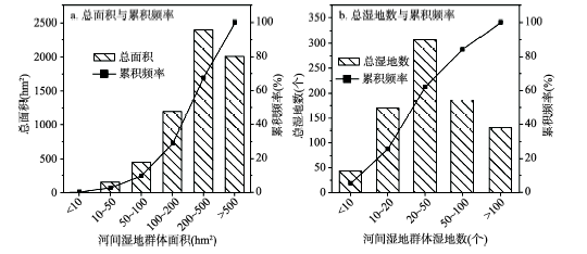
3.2.2 河间湿地群体的面积与湿地数分布特征 河间湿地群体的规模参数主要包括面积与湿地数。研究河段的30个河间湿地群体的面积和湿地数差异显著。从面积来看(表3),最大的河间湿地群体面积达1336.17 hm2,其中河间湿地面积达1058.75 hm2;最小的仅6.46 hm2,其中河间湿地面积2.14 hm2。根据面积大小河间湿地群体可分为4个等级(表5):面积< 100 hm2的为小型、介于100~200 hm2的为中型、介于200~500 hm2的为大型、> 500 hm2的为巨型。
不同面积等级的河间湿地群体的总面积占比存在明显差异(图4),面积> 100 hm2的三类河间湿地群体共计18个,占河间湿地群体数和总面积的60%和90.34%。其中大型河间湿地群体的总面积占比最高,达38.62%;巨型河间湿地群体仅有2个,但总面积占比高达32.38%。可见大型和巨型的河间湿地群体是网状河流体系最主要组成部分。
图4 不同大小河间湿地群体面积与湿地数分布
Fig. 4 Total area and total number of interchannel wetlands in interchannel wetland clusters with different sizes
河间湿地群体内的湿地数也存在明显差异。最多的群体内包含了131个河间湿地,而最少的群体仅包含2个。其中湿地数< 20的河间湿地群体共计16个(表5),占群体数的53.33%,湿地数≥ 20的群体14个,占群体数的46.67%。河间湿地群体湿地数的分布与湿地面积的分布存在差异,未出现向多湿地的河间湿地群体集中的现象。拥有最多总湿地数的河间湿地群体的湿地数介于20~50个,总湿地数占比为39.67%。
表5 不同大小河间湿地群体的面积与河间湿地数
Tab. 5 Total area and total number of interchannel wetlands of interchannel wetland clusters with different sizes
| 面积(hm2) | 描述 | 群体数 | 总面积(hm2) | 总面积占比(%) | 河间湿地数 | 群体数 | 总湿地数占比(%) |
|---|---|---|---|---|---|---|---|
| < 10 | 小型 | 1 | 6.46 | 0.10 | < 10 | 6 | 5.14 |
| 10~50 | 5 | 151.59 | 2.44 | 10~20* | 10 | 20.31 | |
| 50~100 | 6 | 448.02 | 7.22 | 20~50 | 10 | 36.80 | |
| 100~200 | 中型 | 8 | 1193.74 | 19.24 | 50~100 | 3 | 22.10 |
| 200~500 | 大型 | 8 | 2396.24 | 38.62 | > 100 | 1 | 15.65 |
| > 500 | 巨型 | 2 | 2009.11 | 32.38 |
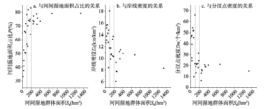
不同大小河间湿地群体的河间湿地面积占比P值存在明显差异(图5),随着河间湿地群体面积的增大P值也存在明显增加。当Su介于0~100 hm2时,河间湿地面积占比P值随Su的增大快速增加,逐步达到70%附近。当Su介于100~500 hm2时,P值增长明显放缓,由70%逐渐增加并稳定在80%附近。当Su超过500 hm2时,P值保持稳定在80%的附近。
图5 河间湿地群体面积与发育程度参数的关系
Fig. 5 Relationship between area and other geomorphologic parameters of interchannel wetland cluster
可见70%的P值应标志着河间湿地发育接近成熟。在70%以下,随着河间湿地群体面积的增加,河间湿地的面积占比也随之快速增加。当P值超过70%时,河间湿地面积占比随河间湿地群体面积增长的速度明显放缓。而80%的P值是该段网状河流河间湿地群体发育的一个上限值,这种情况下河间湿地面积占比总是维持在80%左右,而分支河道总面积占比则维持在20%,二者之间维持着一种平衡关系,表明网状河流系统处于形态最为稳定、分支河道及河间湿地发育的成熟阶段。
P值随Su的增长得益于稳定的水沙条件。在网状河河间湿地群体发育的过程中,由于水沙条件的相对稳定[32],总河道面积也会保持相对稳定,此时伴随河间湿地群体面积增加的以河间湿地面积的扩大为主,表现为P值增加。80%的限制值的出现则是网状河中新河道形成与旧河道废弃达到动态平衡的结果[8, 17]。网状河中河道的形成与废弃实际上是河间湿地的切割与合并过程,在网状河中同样也处于动态平衡的状态。随着河间湿地面积的增加,河道容量下降,为适应过水过程的需要,冲决作用产生,河间湿地发生切割[13],P值增长受限。
岸线密度Dl值与河间湿地群体的面积大小有关(表6),面积小于100 hm2的河间湿地群体有较高的岸线密度。Su为<10 hm2、10~50 hm2和50~100 hm2的河间湿地群体的Dl均值介于12.66~14.65 km/km2,整体均值为13.81 km/km2。而Su介于100~200 hm2时,Dl均值明显下降至11.33 km/km2,较Su < 100 hm2的河间湿地群体低了17.96%,当Su > 200 hm2时,Dl均值进一步下降至9.30 km/km2并开始保持稳定,相较Su < 100 hm2的河间湿地群体低了32.64%。
表6 不同大小河间湿地群体的发育程度特征参数
Tab. 6 Developing level parameters of interchannel wetland clusters with different sizes
| 面积(hm2) | 河间湿地面积占比P (%) | 岸线密度Dl (km/km2) | 分汊点密度Dn (个/km2) | ||||||||
|---|---|---|---|---|---|---|---|---|---|---|---|
| 均值 | 最小 | 最大 | 均值 | 最小 | 最大 | 均值 | 最小 | 最大 | |||
| < 10 | 33.25 | 12.66 | 46.47 | ||||||||
| 10~50 | 48.40 | 37.56 | 66.02 | 14.65 | 13.12 | 15.67 | 38.60 | 24.49 | 54.29 | ||
| 50~100 | 62.31 | 50.52 | 78.33 | 13.31 | 8.37 | 18.04 | 41.14 | 9.91 | 66.08 | ||
| 100~200 | 72.17 | 55.55 | 83.21 | 11.33 | 9.86 | 13.75 | 21.49 | 13.43 | 31.47 | ||
| 200~500 | 74.46 | 71.27 | 78.85 | 9.27 | 6.04 | 11.48 | 16.33 | 6.26 | 20.84 | ||
| > 500 | 79.18 | 79.12 | 79.24 | 9.43 | 8.30 | 10.57 | 18.18 | 15.12 | 21.25 | ||
河间湿地群体的分汊点密度Dn值差异与岸线密度Dl值的变化存在相似的趋势。当Su < 100 hm2时,分汊点密度Dn均值保持在38.60~46.47个/km2,整体均值为40.53个/km2。当Su介于100~200 hm2时,Dn均值明显减小至21.49个/km2,较Su< 100 hm2时下降了46.97%。当Su > 200 hm2时,Dn均值进一步下降至16.70个/km2并且开始保持稳定。
显然,对于该网状河道体系的发展来说河间湿地群体面积Su值在100 hm2和200 hm2是重要的分界值,当Su < 100 hm2时,岸线密度和分汊点密度保持相对稳定,当Su在100~200 hm2时,岸线密度和分汊点密度出现显著的下降;当Su > 200 hm2时,岸线密度和分汊点密度都保持在较低值。
这种发育程度上的差异是由于随着河间湿地面积变化而产生的河间湿地和分支河道主要发育过程的改变。在小型的河间湿地群体中,由于面积的限制,以小型分支河道和河间湿地的发育为主,分支河道的数量和长度快速稳定增加,表现为岸线密度和分汊点密度保持稳定高水平。在中型的河间湿地群体发育中,随着面积的扩大,河间湿地的合并使得部分小型的分支河道发生废弃[8, 25, 44],进而被泛滥水流的悬沙沉积填充而逐渐消失,分支河道数量增加变慢,而其长度发育则更为凸显,表现为岸线密度和分汊点密度的显著下降,其中分汊点密度下降更为明显。在大型和巨型的河间湿地群体发育过程中,河间湿地合并,分支河道消失更为明显,小型河间湿地和分支河道的发育受到限制,以中大型的河间湿地和分支河道发育为主,表现为岸线密度和分汊点密度都稳定维持在较低值。
黄河玛曲段网状河的河间湿地与分支河道局部组合形成的不同的河间湿地群体是该河段网状河的重要特征。该河段河间湿地群体的形成主要有以下原因。
第一,研究区明显存在的主河道(图3)是河间湿地群体形成的重要分割单元和联通诸多支流的主要通道。网状河流体系往往由一个主河道和众多分支河道共同组成[13],主河道水沙输运能力高于分支河道,在河道形态的形成与演化过程中具有主导作用。与其它中小型网状河相比[13, 15, 17, 22],黄河干流由于其规模较大,其主导作用也更为明显。研究河段主河道呈现出弯曲河道的特征,其左右两侧的水动力条件存在明显差异,河道中出现局部集中加积的现象[13],进而导致了两侧河间湿地发育的差异。弯曲主河道在空间上形成了的不规则河曲控制了其两岸的河间湿地发育的规模和范围。使得大型的河间湿地群体主要集中在主河道的凸岸外侧,而凹岸外侧的往往较小。
第二,地形控制削弱条件下的广阔河道带为河间湿地群体的形成提供发育空间。河谷构造的控制是研究河段河型转化的重要原因[32-33],网状河上游的下切型弯曲河道受到了两岸山地的控制,在山谷地区形成相对狭窄的河道,没有发育河间湿地的空间。随着河流从中南部丘陵区流入东部河谷平原区(图1),地形限制因素的减弱,河道带展宽,在研究河段前段,河间湿地得以发育,逐渐形成不同的河间湿地群体;而到了研究河段中段,地形限制因素进一步削弱,特别是主河道左侧,形成了两个巨型的河间湿地群体。
第三,河间湿地上灌木林地的发育是河间湿地群体得以发育并且长时间保存的重要原因。研究河段河间湿地上以灌木林地发育为主,与该区域广泛发育的亚高山草甸草原植被存在明显差异[39]。一方面灌木林地的发育使得洲滩稳定化[44],新的河间湿地形成,河间湿地群体发育。另一方面灌木林地增加了河间湿地对侧向侵蚀的抵抗能力[13],特别是很大程度上削弱了主支河道侧向摆动的能力。河岸的这种强抗蚀能力使得形成的河间湿地能够有效保存,进而形成各类的河间湿地群体。
(1)研究区玛曲网状河段的平面形态上主要由一个弯曲的主河道以及一系列的河间湿地和分支河道组成。河间湿地与分支河道以河间湿地群体的形式出现。从河间湿地的组成上来看河间湿地个体以中小型为主,河间湿地群体以大型和巨型为主。
(2)河间湿地群体中河间湿地面积占比P值是衡量网状河流体系河间湿地与河道发育组合特征的参数。80%的P值标志着此时网状河流系统处于形态最为稳定、分支河道及河间湿地发育的成熟阶段,此时河间湿地与河道的形成与消亡达到动态平衡状态。
(3)岸线密度Dl值与分汊点密度Dn值分别反映了分支河道的长度与数量发育特征。两者随河间湿地群体面积Su的增大呈减小趋势,这是由于不同面积河间湿地群体中分支河道在长度和数量上的发育差异导致。
(4)黄河玛曲段砾质网状河中河间湿地以河间湿地群体的形式出现主要有三方面原因:弯曲主河道的分隔作用,研究河段地形控制因素的削弱以及植被对河岸的维护作用。
The authors have declared that no competing interests exist.
| [1] |
Speculations concerning paleohydrologic controls of terrestrial sedimentation. https://doi.org/10.1130/0016-7606(1968)79[1573:SCPCOT]2.0.CO;2 URL [本文引用: 1] 摘要
Abstract The relations that have been recorded among modern climatic, phytologic, and hydrologic data are used to speculate about the effects of evolving vegetation on the hydrologic cycle. At present the peak of erosion rates occurs in semiarid regions, whereas during prevegetation time erosion rates rose to a plateau, the magnitude of which depended upon the erodibility and weathering characteristics of the rocks. With the appearance of terrestrial vegetation and its colonization of the earth's surface, erosion rates decreased, as did runoff and flood peaks. A review of the relations existing between the morphologic and hydrologic characteristics of river channels demonstrates that fluvial sedimentary deposits are significantly different depending upon the nature of the sediment load moved through the channel. Combining the conclusions obtained from an analysis of hydrologic relations with conclusions concerning effects of type of sediment load upon river morphology, it is possible to speculate on the changing nature of the land phase of the hydrologic cycle before and during the colonization of the landscape by vegetation. During prevegetation time, bed-load channels moved coarse sediments from their sources and spread them as sheets on piedmont areas. With increased plant cover, alluvial deposits were stabilized, but large floods caused periodic flushing of sediment from the system, thereby creating cyclic sedimentary deposits. The influence of climate change on the volume and type of sediment moved from an erosional system became more pronounced as the effect of vegetation on the hydrologic cycle increased. Finally, with the appearance of grasses during the Cenozoic Era, the relations between climate, vegetation, erosion, and runoff became much as today except for the influence of man.
|
| [2] |
A review of the braided river depositional environment. https://doi.org/10.1016/0012-8252(77)90055-1 URL [本文引用: 1] 摘要
Generalized sedimentation models have been developed from a review of more than sixty recent papers on modern and ancient braided-stream deposits. Braided rivers consist of a series of broad, shallow channels and bars, with elevated areas active only during floods, and dry islands. There are three main bar types; longitudinal, comprising crudely bedded gravel sheets; transverse to linguoid, consisting of sand or gravel and formed by downstream avalanche-face progradation; and point or side bars, formed by bedform coalescence and chute and swale development in areas of low energy. Important sediment-forming processes include bar formation, channel-floor dune migration, low-water accretion and overbank sedimentation. Braided-stream deposits consist of up to three gravel facies, five sand facies and two fine-grained facies. Vertical sequences recorded in modern and ancient deposits are of several types: flood-, channel fill-, valley fill-, channel re-occupation- and point bar-cycles. Some of these fine upward and could be confused with meandering-river sequences. Facies assemblages and vertical sequences fall into four main classes, which are proposed as sedimentation models for the interpretation of ancient braided-river deposits in the surface and subsurface: (1) Scott type: consists mainly of longitudinal bar gravels with sand lenses formed by infill of channels and scour hollows during low water. (2) Donjek type: may be dominated by sand or gravel; distinguished by fining-upward cycles caused by lateral point-bar accretion or vertical channel aggradation. Cycles commonly are less than 3 m thick, but cycles up to 60 m may be present, representing valley-fill sequences. Longitudinal and linguoid-bar deposits, channel-floor dune deposits, bar-top and overbank deposits all may be important. (3) Platte type: characterized by an abundance of linguoid bar and dune deposits (planar and trough crossbedding). No well-developed cyclicity, probably owing to a lack of topographic differentiation in the river (no evidence of deep, primary channels, abandoned areas or overbank areas). (4) Bijou Creek type: consists of horizontally laminated sand plus subordinate amounts of sand showing planar crossbedding and ripple marks. Formed during flash floods and may be most typical of ephemeral streams.
|
| [3] |
A classification of alluvial channel systems//Miall A D. Fluvial Sedimentology. |
| [4] |
Sedimentation in anastomosed river systems: Examples from alluvial valley near Bannf, Alberta. https://doi.org/10.1306/212F7991-2B24-11D7-8648000102C1865D URL 摘要
ABSTRACT 3 anastomosed river systems are described. Each reach consists of an interconnected network of low-slope, narrow and deep, straight to sinuous, stable channels that transport coarse sand and gravel. Channels are separated by levees and wetlands composed of silt/mud and vegetation. Gravel-bed braided channels occur upstream from each anastomosed system, joined by a transitional reach comprising stable, elongate, silt islands within braided channels. The 3 anastomosed reaches have formed upstream from elevating base levels caused by deposition of alluvial fans across trunk valleys. -from Authors
|
| [5] |
Anastomosing river system along the middle Yangtze River Basin, Southern China. https://doi.org/10.1016/j.catena.2004.11.007 Magsci [本文引用: 1] 摘要
<h2 class="secHeading" id="section_abstract">Abstract</h2><p id="">The study focuses on the formation processes of the uprivermost (Jingjiang reach) of three anastomosing river reaches along the middle Yangtze River, downstream of the Three Gorges Dam site and 1700 km upriver from the seacoast at Shanghai in southern China. The Jingjiang reach consists of large anastomosing channels: the Songzi, Hudu, Anxiang and Ouchi rivers, which depart from the Yangtze trunk channel and flow southward and southeastward up to 200 km into the Dongting basin and lake; the lake rejoins the Yangtze at Chenglingji. The 7000 km<sup>2</sup> anastomosing reach is characterized by multiple, stable, low gradient channels (0.00004 m/m, 4 cm/km), with low width/depth ratios (<40), low stream powers (<7 W/m<sup>2</sup>) with very high sedimentation rates (33.5–123.3 mm/year) in some channels. Tectonic subsidence, caused by the Himalayan Orogeny, is thought to be the primary forcing mechanism in causing the anastomosing channel processes and deposition.</p><p id="">Historical documents have shown that the Jingjiang channels were caused by repetitive avulsions southward from the Yangtze channel. The earliest recorded avulsion occurred in a high flood period before 1644, and subsequent avulsions have continued to modify the topography. Three major avulsion channels have diverted 14–33% of the discharge and 17–47% of suspended sediment load from the Yangtze channel. These channels have remained laterally stable, a characteristic of anastomosing rivers due to their low gradient, silt-clay banks, densely vegetated natural levees and stable interchannel islands consisting of clayey-silt that supports dense riparian vegetation. Data derived from hydrological gauging stations over the last 45 years demonstrate that total discharge and sediment load of anastomosing channels has decreased by two thirds, largely due to sediment aggradation on channel beds. Reduced sediment load and discharge, and human-caused channel modification were more pronounced in the eastern channels.</p><p id="">With the completion of the 3-Gorges Dam in 2009, the anastomosing channels will cease to carry significant quantities of water and sediment to maintain fluvial vigor. In the next 100 years, the Yangtze main channel may become the only active channel as the anastomosing channels slowly will be infilled.</p>
|
| [6] |
A new classification of fluvial rivers according to channel planform and sediment characteristics.
目前河流分类方案较多,各有所长和不足,不同学科间的河型表述也有一定的差异,不便于相互沟通。在讨论了分别以侵蚀阶段、沉积物搬运方向、河道和河间地的相对沉积速率以及河道平面形态等为标准的代表性河流分类方案的不足之处后,提出一个新的河型分类,把冲积河流分为辫状河、曲流河、分汊河、网状河和直流河五类,以便于沉积学界、地貌学界和水利学界等能够在统一的河型分类的格架中相互借鉴各自的研究成果。
根据河道形态和沉积物特征的河流新分类 .
目前河流分类方案较多,各有所长和不足,不同学科间的河型表述也有一定的差异,不便于相互沟通。在讨论了分别以侵蚀阶段、沉积物搬运方向、河道和河间地的相对沉积速率以及河道平面形态等为标准的代表性河流分类方案的不足之处后,提出一个新的河型分类,把冲积河流分为辫状河、曲流河、分汊河、网状河和直流河五类,以便于沉积学界、地貌学界和水利学界等能够在统一的河型分类的格架中相互借鉴各自的研究成果。
|
| [7] |
Study on anastomosed river with comparative sedimentology. Magsci 摘要
根据比较沉积学原理,论述了现代网状河沉积的沉积过程、沉积韵律特征、平面形态及其环境背景,进而对古代相关沉积类型进行了比较研究,对网状河的形成机制进行探讨和总结,以指导地下同类沉积砂体的油气勘探和开发。
网状河比较沉积学研究 .Magsci 摘要
根据比较沉积学原理,论述了现代网状河沉积的沉积过程、沉积韵律特征、平面形态及其环境背景,进而对古代相关沉积类型进行了比较研究,对网状河的形成机制进行探讨和总结,以指导地下同类沉积砂体的油气勘探和开发。
|
| [8] |
Anastomosing rivers: A review of their classification, origin and sedimentary products. https://doi.org/10.1016/S0012-8252(00)00038-6 URL [本文引用: 4] 摘要
Anastomosing rivers constitute an important category of multi-channel rivers on alluvial plains. Most often they seem to form under relatively low-energetic conditions near a (local) base level. It appears to be impossible to define anastomosing rivers unambiguously on the basis of channel planform only. Therefore, the following definition, which couples floodplain geomorphology and channel pattern, is proposed in this paper: an anastomosing river is composed of two or more interconnected channels that enclose floodbasins. This definition explicitly excludes the phenomenon of channel splitting by convex-up bar-like forms that characterize braided channels. In present definitions of anastomosing rivers, lateral stability of channels is commonly coupled with their multi-channel character. Here, it is suggested that these two properties be uncoupled. At the scale of channel belts, the terms ‘straight’, ‘meandering’ and ‘braided’ apply, whereas at a larger scale, a river can be called anastomosing if it meets the definition given above. This means that, straight, meandering and braided channels may all be part of an anastomosing river system. Straight channels are defined by a sinuosity index; i.e., the ratio of the distance along the channel and the distance along the channel-belt axis is less than 1.3. They are the type of channel that most commonly occurs in combination with anastomosis. The occurrence of straight channels is favoured by low stream power, basically a product of discharge and gradient, and erosion-resistant banks. Anastomosing rivers are usually formed by avulsions, i.e., flow diversions that cause the formation of new channels on the floodplain. As a product of avulsion, anastomosing rivers essentially form in two ways: (1) by formation of bypasses, while bypassed older channel-belt segments remain active for some period; and (2) by splitting of the diverted avulsive flow, leading to contemporaneous scour of multiple channels on the floodplain. Both genetic types of anastomosis may coexist in one river system, but whereas the first may be a long-lived floodplain-wide phenomenon, the latter only represents a stage in the avulsion process on a restricted part of the floodplain. Long-lived anastomosis is caused by frequent avulsions and/or slow abandonment of old channels. Avulsions are primarily driven by aggradation of the channel belt and/or loss of channel capacity by in-channel deposition. Both processes are favoured by a low floodplain gradient. Also of influence are a number of avulsion triggers such as extreme floods, log and ice jams, and in-channel aeolian dunes. Although some of these triggers are associated with a specific climate, the occurrence of anastomosis is not. A rapid rise of base level is conductive to anastomosis, but is not a necessary condition. Anastomosing rivers can be considered an example of equifinality, since anastomosis may result from different combinations of processes or causes. Anastomosing river deposits have an alluvial architecture characterized by a large proportion of overbank deposits, which encase laterally connected channel sand bodies. Laterally extensive, thick lenses of lithologically heterogeneous, fine-grained avulsion deposits can be an important element of the overbank deposits of anastomosing rivers. These deposits may also fully surround anastomosing channel sandstones. Anastomosing channel sand bodies frequently have ribbon-like geometries and may possess poorly developed upward-fining trends, as well as abrupt flat tops. The overbank deposits commonly comprise abundant crevasse splay deposits and thick natural levee deposits. Lacustrine deposits and coal are common in association with anastomosing river deposits. None of these characteristics is unique to anastomosing river deposits, and in most cases, anastomosis (coexistence of channels) cannot be demonstrated in the stratigraphic record.
|
| [9] |
Discussion on channel patterns of anastomosing and anabranched river.
河流的河道平面表态分类有多种方案,其中Rust的分类因为出了网状河流而得到沉积学家的更 多关注,中国地貌学界和水利学界则更关注钱宁的分类,其中包括分汊河流。目前,许多研究人员把网状河流和分汊河流当作同一类型的河流,文中从河型的定义, 河道平面形态、地下沉积物特征、水动力、新河道形成机理和发育的地部位学等方面对分汊河流和网状河流进行对比,根据对比结果认为它们是不同的河型,为了便 于沉积学家、水利学家以及地貌学家之间相互交流各片有关河流的研究成果,需要提出一个更符合实际的冲积河流分类方案。
网状河流的分汊河流的河型归属讨论 .
河流的河道平面表态分类有多种方案,其中Rust的分类因为出了网状河流而得到沉积学家的更 多关注,中国地貌学界和水利学界则更关注钱宁的分类,其中包括分汊河流。目前,许多研究人员把网状河流和分汊河流当作同一类型的河流,文中从河型的定义, 河道平面形态、地下沉积物特征、水动力、新河道形成机理和发育的地部位学等方面对分汊河流和网状河流进行对比,根据对比结果认为它们是不同的河型,为了便 于沉积学家、水利学家以及地貌学家之间相互交流各片有关河流的研究成果,需要提出一个更符合实际的冲积河流分类方案。
|
| [10] |
Comparison of formation model and channel stability between two different sorts of multiple channel river patterns. https://doi.org/10.3321/j.issn:1006-3021.2002.01.016 URL 摘要
在多河道河流中,网状河流作为有别于分汊河流和辫状河流的河型而 提出已经引起人们的注意,但它与分汊河流的区别常常被忽略。为了阐明二者的根本差别,力求从多河道形成模式上对二者进行比较研究。通过对长江下游分汊河流 及荆江网状河流特定河段形成历史及方式的探索,提出河道内的江心洲化模式和河漫滩上的河道化模式分别是分汊河流和网状河流形成的基本途径。由此而决定了网 状河道具有较分汊河流更高的稳定性。
两类多河道河流的形式模式及河道稳定性比较 .https://doi.org/10.3321/j.issn:1006-3021.2002.01.016 URL 摘要
在多河道河流中,网状河流作为有别于分汊河流和辫状河流的河型而 提出已经引起人们的注意,但它与分汊河流的区别常常被忽略。为了阐明二者的根本差别,力求从多河道形成模式上对二者进行比较研究。通过对长江下游分汊河流 及荆江网状河流特定河段形成历史及方式的探索,提出河道内的江心洲化模式和河漫滩上的河道化模式分别是分汊河流和网状河流形成的基本途径。由此而决定了网 状河道具有较分汊河流更高的稳定性。
|
| [11] |
Architectures, relationships between discharges and width/depth ratios of stream cross profiles, and stream powers of anastomosing rivers. Magsci 摘要
网状河流作为一类新河型,已经受到研究者的关注,但对其研究还不充分.该研究基于目前已经报道过的资料及新近取得的研究成果,从河流构型、河道过水断面宽深比与流量关系及能耗率等方面对该河型展开论述,期望引起大家对该河型的兴趣.网状河流在许多方面表现出了独有的特色.从平面构型来看,它以相互连通的多河道围绕非常稳定的泛滥盆地为特征,其中泛滥盆地上植被发育、沼泽湖泊可见.从河道纵、横剖面来看,它具有非常小的河道比降和一般小于40的河道宽深比,总体上属于各类河型中最小的.从沉积体系的剖面构型来看,它以多个孤立的河道砂体"漂浮"在细粒泥质沉积物中为特征.在河道过水断面宽深比与流量的半对数图中可见,其宽深比随流量的增大而减小,并且其散点位于各类河流的最下部.由于其河道比降一般很小,多河道体系中的单个河道的流量相对于其决口前的老河道显然较小,从而其能耗率就相对很小.文中所讨论到的长江三口分流网状河道:东松滋河、西松滋河、虎渡河、藕池河、北藕池河和松澧合流,其能耗率分别为3.0 W/m<sup>2</sup>,5.5 W/m<sup>2</sup>,2.8 W/m<sup>2</sup>,6.4 W/m<sup>2</sup>,3.7 W/m<sup>2</sup>和2.7 W/m<sup>2</sup>,显然都小于10 W/m<sup>2</sup>,这与长江主河道在枝江附近的140 W/m<sup>2</sup>相比,差两个数量级.所有这些特征都预示着网状河流与以长江中下游为代表的分汊河流之间有着完全不同的特性,与其他河型更是大相径庭.
网状河流的构型、流量—宽深比关系和能耗率 .Magsci 摘要
网状河流作为一类新河型,已经受到研究者的关注,但对其研究还不充分.该研究基于目前已经报道过的资料及新近取得的研究成果,从河流构型、河道过水断面宽深比与流量关系及能耗率等方面对该河型展开论述,期望引起大家对该河型的兴趣.网状河流在许多方面表现出了独有的特色.从平面构型来看,它以相互连通的多河道围绕非常稳定的泛滥盆地为特征,其中泛滥盆地上植被发育、沼泽湖泊可见.从河道纵、横剖面来看,它具有非常小的河道比降和一般小于40的河道宽深比,总体上属于各类河型中最小的.从沉积体系的剖面构型来看,它以多个孤立的河道砂体"漂浮"在细粒泥质沉积物中为特征.在河道过水断面宽深比与流量的半对数图中可见,其宽深比随流量的增大而减小,并且其散点位于各类河流的最下部.由于其河道比降一般很小,多河道体系中的单个河道的流量相对于其决口前的老河道显然较小,从而其能耗率就相对很小.文中所讨论到的长江三口分流网状河道:东松滋河、西松滋河、虎渡河、藕池河、北藕池河和松澧合流,其能耗率分别为3.0 W/m<sup>2</sup>,5.5 W/m<sup>2</sup>,2.8 W/m<sup>2</sup>,6.4 W/m<sup>2</sup>,3.7 W/m<sup>2</sup>和2.7 W/m<sup>2</sup>,显然都小于10 W/m<sup>2</sup>,这与长江主河道在枝江附近的140 W/m<sup>2</sup>相比,差两个数量级.所有这些特征都预示着网状河流与以长江中下游为代表的分汊河流之间有着完全不同的特性,与其他河型更是大相径庭.
|
| [12] |
Hydrological processes of an anastomosing river system on the Zhujiang River delta, China.
The interconnected channels of the Xijiang and Beijiang rivers on the Zhujiang River delta and the flood basins surrounded by the channels form an anastomosing river system. The system can be divided into three zones (A, B and C) that are influenced mainly by river current, tidal current or both. To reveal the differences and the similarities between the two rivers and among the three zones in the system, six representative gauging stations were chosen to collect relevant data, such as the stream mean velocity, discharge, width, suspended sediment concentration, water level elevation and the width/depth ratio (W:D). Statistical relationships between these parameters were established. Although the planforms of both rivers on the delta show multiple channels, there are some differences in hydrological processes and channel morphology between the two rivers and among the three zones. The Xijiang channels are more efficient in hydraulic geometry than the Beijiang channels especially in Zone A. In Zone A, the channel W:D of the Beijiang River (about 80) exceeds 40 (the upper limit for an anastomosing river), but the Xijiang River W:D (30.4) is in the range. In zones B and C, the W:D of both rivers is in the range for an anastomosing river pattern. The channel gradient of the Xijiang River is lower than that of the Beijiang. The formation of the anastomosing system, and the differences between the two rivers and among the various channel reaches resulted from river self-adjustment; in this case human activities are not a factor.
|
| [13] |
Development of anastomosing channels in south-central Indiana. https://doi.org/10.1016/0169-555X(91)90005-U URL [本文引用: 7] 摘要
Avulsion is typically associated with aggrading fluvial systems, but the investigated streams are undergoing an episode of degradation. Avulsion occurs because of localized deposition along concave-up channel segments. The concave-up channel reaches are spatially controlled by the occurrence of non-resistant strata that separate beds of resistant sandstone. Thus, the location of avulsion and anastomosing channels is predetermined by the lithology and stratigraphy of the underlying bedrock.
|
| [14] |
Experimental study of avulsion frequency and rate of deposition. https://doi.org/10.1130/0091-7613(1995)0232.3.CO;2 URL 摘要
In existing models of alluvial architecture it is typically assumed that mean avulsion frequency is independent of sedimentation rate. However, if avulsion is driven by superelevation of a river bed above its surrounding flood plain, one might expect avulsion rate to increase with sedimentation rate. We have carried out a series of experiments with laboratory-scale fluvial fans in which we measured the frequency of apical avulsions as a function of mean sedimentation rate on the fan. Avulsion frequency increased strongly with increasing sedimentation rate and then stabilized as mass flows began to influence deposition. In the regime of increasing avulsion frequency, the added volume of sediment needed to trigger an avulsion decreased with increasing sedimentation rate. Although our experimental results cannot simply be scaled up to natural rivers, they suggest the possibility of coupling between avulsion frequency and sedimentation rate that would be strong enough to change qualitatively the results of existing models of alluvial architecture. These models should be applied with caution until avulsion mechanics are better understood.
|
| [15] |
Interchannel hydraulic geometry and hydraulic efficiency of the anastomosing Columbia River, southeastern British Columbia, Canada. https://doi.org/10.1002/esp.497 URL [本文引用: 1] 摘要
The morphodynamics of the anastomosing channel system of upper Columbia River in southeastern British Columbia, Canada, is examined using an adaptation of conventional hydraulic geometry termed interchannel hydraulic geometry. Interchannel hydraulic geometry has some of the characteristics of downstream hydraulic geometry but differs in that it describes the general bankfull channel form and hydraulics of primary and secondary channels in the anastomosing channel system. Interchannel hydraulic geometry generalizes these relationships and as such becomes a model of the geomorphology of channel division and combination. Interchannel hydraulic geometry of upper Columbia River, based on field measurements of flow velocity and channel form at 16 test sections, is described well by simple power functions: wbf = 3·24 Q bf 0·64; dbf = 1·04 Q bf 0·19; vbf = 0·30 Q bf 0·17. These results, with other related measurements of flow resistance, imply that channel splitting leads to hydraulic inefficiency (higher flow resistance) on the anastomosing Columbia River. Because these findings differ from those reported in studies elsewhere, we conclude that hydraulic efficiency does not provide a general explanation for anabranching in river channels. Copyright 08 2003 John Wiley & Sons, Ltd.
|
| [16] |
|
| [17] |
|
| [18] |
|
| [19] |
Nogueira A C R, Truckenbrodt W. The anastomosing pattern and the extensively distributed scroll bars in the middle Amazon River. https://doi.org/10.1002/esp.3249 Magsci [本文引用: 2] 摘要
The middle Amazon River, between the confluences of the Negro and Madeira Rivers in Brazil, shows an anastomosing morphology with relatively stable, multiple interconnected channels that locally enclose floodbasins. Additionally, this system is characterized by sinuous secondary channels with meander development, discontinuous natural levees concentrated on the concave banks and extensively distributed scroll bars mainly in the islands, related to subrecent and present-day migration of mainly secondary channels. This distinguishes the Amazon from many other anastomosing rivers that have laterally stable, non-meandering channels. We analyzed sedimentary processes using field data, morphology and channel changes trough a temporal analysis using remote sensing data and obtained optically stimulated luminescence (OSL) dating to understand the genesis of this large anastomosing river and the development of its meandering secondary channels. Scroll bars have developed in a multichannel river system at least since 7.5 +/- 0.85 ka. Avulsion is inferred to have played a minor role in the formation of this anastomosing system, with only one documented case while mid-channel bar formation and chute cut-offs of the main and secondary channels are the main formative mechanisms of anastomosis in this system. Differences in resistance to erosion control the relatively straight main channel and allow secondary channels to develop a meandering platform. Vegetation contributes to the relative stability of islands and the floodplain. Low gradient and high average aggradation rate (1.1 mm yr(-1)) are conditions which favor the development of anastomosis. Additionally, stable external conditions, low abandonment rate of older channels and independence from high avulsion frequency suggest a long-lived, semi-static type of anastomosing river in this reach of the Amazon. Copyright (C) 2012 John Wiley & Sons, Ltd.
|
| [20] |
Channel patterns and terraces of the Loup Rivers in Nebraska. U.S. Geological Survey Professional Paper 422-D, |
| [21] |
Braiding and meandering parameters//Best J L, Bristow C S. Braided Rivers. London, |
| [22] |
Berendsen H J A. Avulsions, channel evolution and floodplain sedimentation rates of the anastomosing upper Columbia River, British Columbia, Canada. https://doi.org/10.1046/j.1365-3091.2002.00489.x URL [本文引用: 2] 摘要
Abstract Ages of channels of the anastomosing upper Columbia River, south-eastern British Columbia, Canada, were investigated in a cross-valley transect by C dating of subsurface floodplain organic material from beneath levees. The avulsion history within the transect was deduced from these data, and morphological stages in channel development were recognized. Additionally, floodplain sedimentation rates were established. The new data demonstrate that the upper Columbia River is a long-lived, dynamic anastomosing system. Results show that anastomosis at the study location has persisted since at least 2700 cal. years BP, with avulsions occurring frequently. At least nine channels have formed in the studied cross-valley transect within the past 300065years. Channel lifetimes from formation to abandonment appear to be highly variable, ranging from approximately 800 to 300065years. Log jams provoking avulsions and/or silting up of old channels are proposed as reasons for this variability. Long-term average floodplain sedimentation rates appear to be significantly lower than previously proposed by Smith (1983, Int. Assoc. Sedimentol. Spec. Publ., 6, 155–168). A long-term (455065years) average of 1·7565mm65year(after compaction) was based on C dates, while a short-term sedimentation rate of 0·865mm was determined for a single, relatively small, seasonal flood in 1994 using sediment traps. However, short-term sedimentation rates vary considerably over the floodplain, with levees aggrading up to four times faster than floodbasins. Channels of the upper Columbia River anastomosed reach follow a consistent pattern in their development, with each stage being characterized by different morphology and processes. Channel evolution comprises the following succession: (1) avulsion stage, in which a crevasse splay channel deepens by scour and levee sedimentation; (2) widening and deepening stage, in which bank slumping and bed scouring dominates; (3) infilling stage, in which either channel narrowing (bank accretion) or channel shallowing (bed accretion) takes place; and (4) abandonment stage, in which the residual (remnant) channel is filled exclusively by silt, clay and organic material. Vertical stacking (super- imposition) of active channels on recent channel-fill sand bodies is a notable feature of the upper Columbia River, which suggests that reoccupation of residual channels is a common process.
|
| [23] |
What is the relative effect of space and time to explain the braided river width and island patterns at a regional scale? https://doi.org/10.1002/rra.2714 URL [本文引用: 1] 摘要
Abstract Several decades of human activities have severely impacted braided rivers worldwide. Despite their widespread disappearance, some remnant braided sectors are still held in the French Rhone basin, mainly in the south-east of France. In this paper, we analyse the evolutionary pattern of 53 braided reaches, focusing on the active channel width and island patterns, by comparing aerial photographs from the 1950s and 2000s (Institut G茅ographique National). Because different braided patterns exist (e.g. bar versus island-braided), we tested the relative effect of geographical and temporal factors. The hypothesis is that three main biogeomorphological braided types exist (i.e. defined through the presence, the amount and the relative size of vegetated islands), based on the combined effect of the following: (i) their position along the river network (i.e. river gradient, altitude and sediment regime) and (ii) the temporal effect represented by the time since the last large flood, that is, the recent flood history. Our results show that even if the regional context (climate and sediment regime mainly) plays a key role, the temporal factor, represented by recent flood history, seems to heavily influence the response of the width pattern and vegetation recovery. Local factors (i.e. topography and groundwater) may also have an impact, but their influence has no effect at the regional level. These results support braided river management (conservation and/or restoration actions) in the Rhone basin and provide a better understanding of the range of braided rivers' functioning. Further studies (e.g. multidate retrospective survey) are needed to better understand the role of flood events on braided pattern and vegetation recovery. Copyright 漏 2013 John Wiley & Sons, Ltd.
|
| [24] |
Channel bar dynamics on multi-decadal timescales in an active meandering river. https://doi.org/10.1002/esp.2214 Magsci [本文引用: 1] 摘要
Occurrence and development of channel bars are major components of the morphodynamics of rivers and their relation to river meandering has been much explored through theory and experimentation. However, field and documentary data of characteristics and evolution over timescales from years to several decades are lacking. Four sets of aerial photographs in the period 1984-2007 were used to map and quantify bar numbers and areas in GIS on an active meandering reach. Bar types were classified. Additional temporal resolution was provided by annual ground photography and mapping for 1981-2010. Analysis was extended backward by use of large scale Ordnance Survey maps from 1873 onwards. As expected, point bars are the most common type but 'free' bars of several types are major components of bar deposition. Point bars and attached bars are significantly larger in size than mid-channel and side bars. Spatial distribution of bars varies down the reach and over time but is related to channel sinuosity, gradient and mobility and to bend evolution. Different types of bar occur in distinctive channel locations, with point and concave-bend bars in zones of high curvature. Bar activity shows a relation with discharge events and phases and possibly with changing riparian conditions, but superimposed on this is a common sequence of bar evolution from incipient gravel mid-channel bars to full floodplain integration. This life-cycle is identified as 7-9 years on average. No evidence for mobility of free bars within the course is found. The results are compared with bar and bend theory; the bars are forced and conform in general to bend theory but detailed variation relates to geomorphic factors and to autogenic sequences of bends and bars. Mid-channel bars are width induced. Variability of bar occurrence needs to be taken into account in river management and ecological evaluation, including for the EU WFD. Copyright (C) 2011 John Wiley & Sons, Ltd.
|
| [25] |
Processes of fluvial island formation, with examples from Plum Creek, Colorado and Snake River, Idaho. https://doi.org/10.1007/BF03161670 URL [本文引用: 2] 摘要
A fluvial island is a landform, elevated above and surrounded by stream-channel branches or waterways, that persists sufficiently long to establish permanent vegetation. Natural fluvial islands occur in any part of a drainage network but most commonly in montane, piedmont-valley, and coastal flood-plain environments. Processes, often interactive, by which islands form include avulsion (the sudden separation of land by a flood or by an abrupt change in the course of a stream), rapid and gradual channel incision, channel migration, dissection of both rapidly and slowly deposited bed sediment, and deposition of bed sediment on a vegetated surface or behind a channel obstruction. Products of high-energy conditions, fluvial islands typically lack stability over decades to millennia. Fluvial islands in Plum Creek, Colorado, USA, results of sorting processes following a recent high-magnitude flood, and in the Snake River, Idaho, USA, partly results of the Pleistocene Bonneville Flood, Illustrate how islands form, develop, and disappear. The examples consider differing conditions of island shape, size, height, sediment, and vegetation.
|
| [26] |
Proposed fluvial island classification scheme and its use for river restoration. https://doi.org/10.1002/rra.1395 Magsci [本文引用: 1] 摘要
Fluvial islands are present in nearly all natural and regulated rivers. They are important from hydrological, biological, geopolitical and socio-economic points of view. As ubiquitous as islands are, consideration of islands is relatively absent in most river restoration concepts. The natural river processes that allow for island formation can easily be integrated into typical river classifications. To begin, an island classification scheme is proposed that can become a tool for improved river classifications and restoration projects. In developing an island classification scheme, the objectives are similar to those of previous river classification methods. By observing island characteristics, inductive generalizations may be made about the river's hydrologic and ecologic potential. In river hierarchies, the distinguishing variables used to describe streams were characteristics that could easily be discerned from their appearances, i.e. field-determinable features. A similar approach is sought for island classification. The distinguishing characteristics of any island may be sorted into three basic categories: those that can be measured from a topographic map or an aerial photograph; those that can be measured in situ at the island and those that can be inferred from either a known history of the island or from the other characteristics of the island. Once all the suitable characteristics were identified, a matrix for island classification was created which can be used to classify island origin and type. The better that the inter-relationship between island formation, channel processes and watershed processes are understood, the better the natural bio-physical regime of the river corridor can be identified and incorporated into restoration plans. Copyright (C) 2010 John Wiley & Sons, Ltd.
|
| [27] |
Island dynamics in a braided river from analysis of historical maps and air photographs. https://doi.org/10.1002/rra.1086 URL [本文引用: 3] 摘要
Abstract An analysis of island and active corridor dynamics is presented for a 16 km island-braided reach of the gravel-bed Tagliamento River (Italy) based upon information extracted, geocorrected and registered to a common base from three map (1803, 1833, 1927) and nine aerial photograph sources (1944/6, 1954, 1970, 1986, 1991, 1996, 1997, 1999, 2005). The active corridor width showed a general decline over the study period but with some recent widening. Adjustments in active corridor width were achieved through processes of floodplain avulsion, island attachment and progressive encroachment of the edge of the active corridor across gravel areas. These adjustments were accompanied by the preferential creation of dissection (floodplain avulsion) islands during periods of widening and the construction of mid islands within the corridor during periods of narrowing. Changes in island extent were achieved by rapid island turnover, which reached a maximum rate of over 50% per annum when corridor narrowing was most rapid between 1970 and 1991. Very few island surfaces were found to persist for more than 24 years. Despite this enormous dynamism and apparent cyclic behaviour, between 1944/6 and 2005 the ratio of island area to active corridor area remained relatively constant at around 0.08 and supported a consistently high bankfull shoreline to downstream length ratio of around 6 km · km 鈭1 . These intrinsic properties of the dynamics of the study reach and other island-braided channels need to be recognized and maintained by river managers because they represent a characteristic habitat dynamism that is crucial to the maintenance of ecological integrity. Copyright 漏 2008 John Wiley & Sons, Ltd.
|
| [28] |
Form and growth of bars in a wandering gravel-bed river. https://doi.org/10.1002/esp.1831 URL 摘要
The changing form of developing alluvial river bars has rarely been studied in the field, especially in the context of the fixed, compound, mainly alternate gravel bars that are the major morphological feature of the wandering style. Century scale patterns of three-dimensional growth and development, and the consequent scaling relations of such bars, are examined along the gravel-bed reach of lower Fraser River, British Columbia, Canada. A retrospective view based on maps and aerial photographs obtained through the twentieth century shows that individual bars have a life history of about 100 years, except in certain, protected positions. A newly formed gravel bar quickly assumes its ultimate thickness and relatively quickly approaches its equilibrium length. Growth continues mainly by lateral accretion of unit bars, consistent with the lateral style of instability of the river. Bar growth is therefore allometric. Mature bars approach equilibrium dimensions and volume that scale with the overall size of the channel. Accordingly, the bars conform with several published criteria for the ultimate dimensions of alternate barforms. Sand bars, observed farther downstream, have notably different morphology. Fraser River presents a typical wandering channel planform, exhibiting elements of both meandered and low-order braided channels. Hydraulic criteria to which the Fraser bars conform illustrate why this planform develops and persists. The modest rate of bed material transfer along the channel - typical of the wandering type - determines a century-length time scale for bar development. This time scale is consistent with estimates that have been made for change of the macroform elements that determine the overall geometry of alluvial channels. Copyright 漏 2009 John Wiley & Sons, Ltd.
|
| [29] |
Medium-term fluvial island evolution in a disturbed gravel-bed river (Piave River, Northeastern Italian Alps). Geografiska Annaler: Series A, https://doi.org/10.1111/geoa.12034 URL 摘要
<P>River islands are defined as discrete areas of woodland vegetation surrounded by either water-filled channels or exposed gravel. They exhibit some stability and are not submerged during bank-full flows. The aim of the study is to analyze the dynamics of established, building, and pioneer islands in a 30-km-long reach of the gravel-bed Piave River, which has suffered from intense and multiple human impacts. Plan-form changes of river features since 1960 were analyzed using aerial photographs, and a LiDAR was used to derive the maximum, minimum and mean elevation of island surfaces, and maximum and mean height of their vegetation. The results suggest that established islands lie at a higher elevation than building and pioneer islands, and have a thicker layer of fine sediments deposited on their surface after big floods. After the exceptional flood in 1966 (RI65>65200 years) there was a moderate increase in island numbers and extension, followed by a further increase from 1991, due to a succession of flood events in 1993 and 2002 with RI65>6510 years, as well as a change in the human management relating to the control of gravel-mining activities. The narrowing trend (1960–1999) of the morphological plan form certainly enhanced the chance of islands becoming established and this explains the reduction of the active channel, the increase in established islands and reduction of pioneer islands.</P>
|
| [30] |
Islands in a European mountain river: Linkages with large wood deposition, flood flows and plant diversity. https://doi.org/10.1016/j.geomorph.2012.09.016 URL [本文引用: 1] 摘要
78 Island formation is initiated by deposition of large vegetative particles on bars. 78 Upstream island growth typifies rivers supplied with wood capable of re-sprouting. 78 Timing and magnitude of floods control the occurrence and longevity of islands. 78 Islands highly contribute to the overall floristic diversity of river corridor. 78 Islands re-establishing promotes restoration of degraded mountain rivers.
|
| [31] |
Analysis of river pattern transformations in the Yellow River Basin. https://doi.org/10.11820/dlkxjz.2008.02.002 URL Magsci [本文引用: 3] 摘要
<p>黄河以其高含沙水流以及下游河道的高沉积速率而著称于世。迄今的研究, 主要针对黄河中下游流域的 侵蚀、水文泥沙和河床演变方面的研究, 而对黄河流域主支流发生河型转化的现象关注不够。在黄河的不同河段, 河型的变化频繁, 类型多样, 现象复杂, 是研究者不可回避的科学问题。本文选取黄河上游第一弯的玛曲河段、黄河 上游末段托克托附近河段及黄河下游高村上下河段来研究河型转化的形式及影响因素。玛曲河段沿流向发生网状 河型→弯曲河型→辫状河型的转化现象, 该系列转化呈现出由极稳定河型向极不稳定河型的转化, 这与世界上通 常可以观察到的沿流向不稳定河型向稳定河型转化的情况完全相反。这主要受到地壳的抬升、上下峡谷卡口、水动 力特征、边界沉积物特征及植被的区域分布等因素的控制。托克托附近沿流向发生了弯曲河型→顺直河型转化的 现象, 这是较稳定河型向极稳定河型的转化, 主要受到边界沉积物、水动力等因素的控制。高村上下河段沿流向发 生的辫状河型→弯曲河型转化的现象, 是由极不稳定河型向较稳定河型转化的现象, 河道边界沉积物及水动力是 其主要控制因素, 人工大堤只是限制了河道摆动的最大幅度, 对河型的性质影响不大, 但其上游河段修筑的水库导 致下泻的水流在辫状河段的侵蚀能力增强而使其边界沉积物粗化, 并将泥质物大量沉积在弯曲河段, 客观上促进 了河型的转化。</p>
黄河流域河型转化现象初探 .https://doi.org/10.11820/dlkxjz.2008.02.002 URL Magsci [本文引用: 3] 摘要
<p>黄河以其高含沙水流以及下游河道的高沉积速率而著称于世。迄今的研究, 主要针对黄河中下游流域的 侵蚀、水文泥沙和河床演变方面的研究, 而对黄河流域主支流发生河型转化的现象关注不够。在黄河的不同河段, 河型的变化频繁, 类型多样, 现象复杂, 是研究者不可回避的科学问题。本文选取黄河上游第一弯的玛曲河段、黄河 上游末段托克托附近河段及黄河下游高村上下河段来研究河型转化的形式及影响因素。玛曲河段沿流向发生网状 河型→弯曲河型→辫状河型的转化现象, 该系列转化呈现出由极稳定河型向极不稳定河型的转化, 这与世界上通 常可以观察到的沿流向不稳定河型向稳定河型转化的情况完全相反。这主要受到地壳的抬升、上下峡谷卡口、水动 力特征、边界沉积物特征及植被的区域分布等因素的控制。托克托附近沿流向发生了弯曲河型→顺直河型转化的 现象, 这是较稳定河型向极稳定河型的转化, 主要受到边界沉积物、水动力等因素的控制。高村上下河段沿流向发 生的辫状河型→弯曲河型转化的现象, 是由极不稳定河型向较稳定河型转化的现象, 河道边界沉积物及水动力是 其主要控制因素, 人工大堤只是限制了河道摆动的最大幅度, 对河型的性质影响不大, 但其上游河段修筑的水库导 致下泻的水流在辫状河段的侵蚀能力增强而使其边界沉积物粗化, 并将泥质物大量沉积在弯曲河段, 客观上促进 了河型的转化。</p>
|
| [32] |
Analysis of controls upon channel planform at the First Great Bend of the Upper Yellow River, Qinghai-Tibet Plateau. https://doi.org/10.1007/s11442-013-1047-1 Magsci [本文引用: 3] 摘要
<p>The 270 km long section of the Upper Yellow River at the First Great Bend is comprised of single channel and multiple channel systems that alternate among anastomosing, anabranching, meandering and braided reaches. The sequence of downstream pattern changes is characterized as: anastomosing-anabranching, anabranching-meandering, meandering-braided and braided-meandering. Remote sensing images, DEM data and field investigations are used to assess and interpret controls on these reach transitions. Channel slope and bed sediment size are key determinants of transitions in channel planform. Anastomosing reaches have a relatively high bed slope (0.86‰) and coarser sediment bed material (<em>d</em><sub>50</sub> = 3.5 mm). In contrast, meandering reaches have a low slope (0.30‰) and fine sediment bed material (<em>d</em><sub>50</sub> = 0.036 mm). The transition from a meandering to braided pattern is characterized by an increase in channel width-depth ratio, indicating the important role of bank strength (i.e. cohesive versus non-cohesive versus channel boundaries). Interestingly, the braided-meandering and meandering-braided transitions are coincident with variable flow inputs from tributary rivers (Baihe and Heihe rivers respectively). Theoretical analysis of the meandering-braided transition highlights the key control of channel width-depth ratio as a determinant of channel planform.</p>
|
| [33] |
Yu Guo'an, et al. River pattern transition and its causes along Maqu reach of Yellow River source region. https://doi.org/10.3969/j.issn.0468-155X.2013.03.010 URL [本文引用: 4] 摘要
黄河源玛曲河段是一段特殊的冲积平原河道,接连出现了网状河型、分汊河型、弯曲河型和辫状河型,在270km的流程里,冲积河型发生了4次河型沿程变化。通过遥感图像和野外调查相结合,描述玛曲河段河型多样性和河道的基本特征,分析河型沿程变化的原因。玛曲河段的冲积河道主要发生4次河型变化,即网状型-分汊型、网状型-弯曲型、弯曲型-辫状型和辫状型-弯曲型。网状型-分汊型变化的原因是地形限制,泥沙淤积形成沙洲和植被发育。网状型-弯曲型变化的原因是地形限制、河床比降由大变小、河岸物质组成沿程变细。弯曲型-辫状型变化的原因是白河入汇、河床比降变大。辫状型-弯曲型变化的主原因是下游峡谷段河床下切和黑河入汇。
黄河源玛曲河段河型沿程变化及其原因 .https://doi.org/10.3969/j.issn.0468-155X.2013.03.010 URL [本文引用: 4] 摘要
黄河源玛曲河段是一段特殊的冲积平原河道,接连出现了网状河型、分汊河型、弯曲河型和辫状河型,在270km的流程里,冲积河型发生了4次河型沿程变化。通过遥感图像和野外调查相结合,描述玛曲河段河型多样性和河道的基本特征,分析河型沿程变化的原因。玛曲河段的冲积河道主要发生4次河型变化,即网状型-分汊型、网状型-弯曲型、弯曲型-辫状型和辫状型-弯曲型。网状型-分汊型变化的原因是地形限制,泥沙淤积形成沙洲和植被发育。网状型-弯曲型变化的原因是地形限制、河床比降由大变小、河岸物质组成沿程变细。弯曲型-辫状型变化的原因是白河入汇、河床比降变大。辫状型-弯曲型变化的主原因是下游峡谷段河床下切和黑河入汇。
|
| [34] |
Fluvial diversity in relation to valley setting in the source region of the Yangtze and Yellow Rivers. https://doi.org/10.1007/s11442-013-1046-2 Magsci [本文引用: 1] 摘要
<p>The spatial distribution of valley setting (laterally-unconfined, partly-confined, or confined) and fluvial morphology in the source region of the Yangtze and Yellow Rivers is contrasted and analyzed. The source region of the Yangtze River is divided into 3 broad sections (I, II and III) based on valley setting and channel gradient, with the upstream and downstream sections being characterized by confined (some reaches partly-confined) valleys, while the middle section is characterized with wide and shallow, laterally-unconfined valleys. Gorges are prominent in sections I and III, while braided channel patterns dominate section II. By contrast, the source region of the Yellow River is divided into 5 broad sections (sections I-V) based on valley characteristics and channel gradient. Sections I, II and IV are alluvial reaches with mainly laterally-unconfined (some short reaches partly-confined) valleys. Sections III and V are mainly confined or partly-confined. Greater morphological diversity is evident in the source region of the Yellow River relative to the upper Yangtze River. This includes braided, anabranching, anastomosing, meandering and straight alluvial patterns, with gorges in confined reaches. The macro-relief (elevation, gradient, aspect, valley alignment and confinement) of the region, linked directly to tectonic movement of the Qinghai-Tibet Plateau, tied to climatic, hydrologic and biotic considerations, are primary controls upon the patterns of river diversity in the region.</p>
|
| [35] |
An environmental gradient of vegetative controls upon channel planform in the source region of the Yangtze and Yellow rivers. https://doi.org/10.1016/j.catena2014.02.010 URL Magsci [本文引用: 2] 摘要
Alluvial reaches in the source region of the Yangtze and Yellow Rivers, located atop the Qinghai-Tibetan Plateau and mostly at elevations that are typically higher than 3500 m, have similar slope and valley setting conditions. However, alluvial reaches in the source region of the Yangtze River exhibit predominantly braided channel planforms, while equivalent reaches in the source region of the Yellow River have more diverse planform morphologies including anastomosing/braided, anabranching/braided, and anabranching/anastomosing reaches. The regional gradient of variation in riparian vegetation and interactions between vegetation development and hydrologic process are shown to be major factors influencing this difference in channel planforms. A short period above freezing, coincident with recurrent yet pulsed flows in the source region of the Yangtze River, suppress riparian vegetation growth, promoting the development of braided channel morphologies. In contrast, a milder climate, coincident with less variable flows in the source region of the Yellow River, permit the establishment of different forms of riparian vegetation, thereby supporting the development of a wider range of channel planform morphologies. (C) 2014 Elsevier B.V. All rights reserved.
|
| [36] |
Geomorphic diversity in the braided-wandering Belá River, Slovak Carpathians, as a response to flood variability and environmental changes. https://doi.org/10.1016/j.geomorph.2016.01.002 URL [本文引用: 1] 摘要
61We assess the effect of different flood periods on river evolution during six last decades.61The post-flood period serial geomorphic analysis (POPSEGA) was used.61Decrease in active zone area and geomorphic diversity of the river was identified.61Increase in island area and reduction in river bank shift are related to changes in floods during last decades.
|
| [37] |
Planform dynamics of braided streams. https://doi.org/10.1002/esp.1755 URL [本文引用: 2] 摘要
The high dynamism and complexity of braided networks poses a series of open questions, significant for river restoration and management. The present work is aimed at the characterization of the morphology of braided streams, in order to assess whether the system reaches a steady state under constant flow conditions and, in that case, to determine how it can be described and on which parameters it depends. A series of 14 experimental runs were performed in a laboratory physical model with uniform sand, varying the discharge and the longitudinal slope. Planimetric and altimetric configurations were monitored in order to assess the occurrence of a steady state. A set of parameters was considered, such as the braid-plain width and the number and typology of branches and nodes. Results point out that a relationship exists between braiding morphology and two dimensionless parameters, related to total water discharge and stream power. We found that network complexity increases at higher values of water discharge and a larger portion of branches exhibits morphological activity. Results are then compared to the outputs of a simple one-dimensional model, that allows to easily predict the average network complexity, once the bed topography is known. Model computations permit also the investigation of the effect of water discharge variations and to compare different width definitions. The at-a-station variability of planimetric parameters shows a peculiar behaviour, both regarding number of branches and wetted width. In particular, the analysis of the relationship between width and discharge highlighted relevant differences in comparison to single thread channel. Copyright 漏 2009 John Wiley & Sons, Ltd.
|
| [38] |
Status, causes and protection counter measures of wetland degradation in Maqu County in the Upper Yellow River. 黄河上游玛曲湿地退化现状、成因及保护对策 . |
| [39] |
Changes in ecological patterns of Maqu alpine wetland in Yellow River Source Area during 2000-2010. https://doi.org/10.11820/dlkxjz.2014.03.004 Magsci [本文引用: 3] 摘要
玛曲湿地作为黄河上游重要的水源涵养以及补给区之一,对于调节黄河水量与泥沙量、维持生物多样性和区域生态平衡以及实现社会经济的可持续发展具有重要意义。为揭示和分析近10 年来玛曲高寒湿地系统动态变化特征及其区域差异性,应用2000 年、2010 年两期Landsat TM卫星影像提取玛曲景观类型信息,对玛曲湿地分布格局变化进行分析;利用S-G 滤波以及最大值合成法处理后的2000-2010 年MODIS归一化植被指数(<i>NDVI</i>)数据,进行一元线性回归分析,模拟湿地生态系统的空间演变趋势;运用长期气候观测数据,采用最小二乘法对玛曲湿地变化与气候之间的相关关系进行分析与探讨。结果表明:近10 年来玛曲夏季年际<i>NDVI</i>值呈现波动减小的趋势,“黄河第一弯”玛曲腹地的阿万仓处<i>NDVI</i>减少明显,且存在沼泽草甸向亚高山草甸类型转化趋势。另外,玛曲高寒湿地变化与降水量及温度的年际变化均有关系,但与降水量的相关关系更强。
2000-2010年黄河源玛曲高寒湿地生态格局变化 .https://doi.org/10.11820/dlkxjz.2014.03.004 Magsci [本文引用: 3] 摘要
玛曲湿地作为黄河上游重要的水源涵养以及补给区之一,对于调节黄河水量与泥沙量、维持生物多样性和区域生态平衡以及实现社会经济的可持续发展具有重要意义。为揭示和分析近10 年来玛曲高寒湿地系统动态变化特征及其区域差异性,应用2000 年、2010 年两期Landsat TM卫星影像提取玛曲景观类型信息,对玛曲湿地分布格局变化进行分析;利用S-G 滤波以及最大值合成法处理后的2000-2010 年MODIS归一化植被指数(<i>NDVI</i>)数据,进行一元线性回归分析,模拟湿地生态系统的空间演变趋势;运用长期气候观测数据,采用最小二乘法对玛曲湿地变化与气候之间的相关关系进行分析与探讨。结果表明:近10 年来玛曲夏季年际<i>NDVI</i>值呈现波动减小的趋势,“黄河第一弯”玛曲腹地的阿万仓处<i>NDVI</i>减少明显,且存在沼泽草甸向亚高山草甸类型转化趋势。另外,玛曲高寒湿地变化与降水量及温度的年际变化均有关系,但与降水量的相关关系更强。
|
| [40] |
Analysis on variety trend of runoff between Dari and Maqu in the headwater region of Yellow River in the past 50 years.
<p>本文提出了用于长时间序列变化趋势预测分析的局部主周期分析方法,并依据黄河源区达日至玛曲段1956~2000年长时间序列径流量实测资料,对天然径流量多时间尺度变化特征及未来变化趋势作了实例分析预测。结果表明:①径流量序列具有多时间尺度变化特征,并且存在3.2a、7.5a、19.5a和36.5a左右的主周期。②径流量变化趋势为:在1956~1969年偏多、1969~1975年偏少、1975~1986年偏多、1986~2004年偏少、2004~2017年偏多、2017~2020年为平水期。1986年以来出现的枯水期,在2004年左右以后将得到改变。③径流量年际变化主要是受气候变化影响所致,人类活动作用不显著。④主周期具有时效性,只有在一定时段内才有意义。</p>
黄河源区达日至玛曲段近50年径流量变化趋势分析 .
<p>本文提出了用于长时间序列变化趋势预测分析的局部主周期分析方法,并依据黄河源区达日至玛曲段1956~2000年长时间序列径流量实测资料,对天然径流量多时间尺度变化特征及未来变化趋势作了实例分析预测。结果表明:①径流量序列具有多时间尺度变化特征,并且存在3.2a、7.5a、19.5a和36.5a左右的主周期。②径流量变化趋势为:在1956~1969年偏多、1969~1975年偏少、1975~1986年偏多、1986~2004年偏少、2004~2017年偏多、2017~2020年为平水期。1986年以来出现的枯水期,在2004年左右以后将得到改变。③径流量年际变化主要是受气候变化影响所致,人类活动作用不显著。④主周期具有时效性,只有在一定时段内才有意义。</p>
|
| [41] |
Type and distribution of aeolian geomorphology at Marqu Region of Upstream Yellow River.
玛曲草原是著名的高原牧场,也是黄河上游重要的水源涵养地,通过卫星影像分析和实地观测数据,对其风沙地貌进行分类,以期为沙化草地治理提供参考。玛曲沙化草地的风沙地貌可分为4级17类。横向沙丘(新月形沙丘)主要分布在河岸和黄河的一级或二级阶地上,单个的新月形沙丘最大高度可达12 m, 64%的新月形沙丘迎风坡走向与当地起沙风向一致。分布在古河道或古三角洲的流动和半流动纵向沙丘(沙垄)高度小于3 m,51%的沙垄走向与当地起沙风向相同。低山上的沙垄和沙片出现在山顶或其阳坡,地形过渡带形成风蚀坎。风蚀洼地与固定和半固定沙地伴生,60%左右的风蚀洼地横切面为不规则椭圆和马蹄形;其深度与长轴呈正比例函数关系。古(现代)沉积物提供了丰富的沙源,大风、冻融、土层的岩性差异、脆弱的植被、人类过渡干扰和微地形促成了玛曲草地沙化和风沙地貌分异。通过对风沙地貌分类、分析,提出了以保护草皮免受破坏,为防止玛曲草地沙化的主要措施。
黄河上游玛曲地区风沙地貌的类型及其分布 .
玛曲草原是著名的高原牧场,也是黄河上游重要的水源涵养地,通过卫星影像分析和实地观测数据,对其风沙地貌进行分类,以期为沙化草地治理提供参考。玛曲沙化草地的风沙地貌可分为4级17类。横向沙丘(新月形沙丘)主要分布在河岸和黄河的一级或二级阶地上,单个的新月形沙丘最大高度可达12 m, 64%的新月形沙丘迎风坡走向与当地起沙风向一致。分布在古河道或古三角洲的流动和半流动纵向沙丘(沙垄)高度小于3 m,51%的沙垄走向与当地起沙风向相同。低山上的沙垄和沙片出现在山顶或其阳坡,地形过渡带形成风蚀坎。风蚀洼地与固定和半固定沙地伴生,60%左右的风蚀洼地横切面为不规则椭圆和马蹄形;其深度与长轴呈正比例函数关系。古(现代)沉积物提供了丰富的沙源,大风、冻融、土层的岩性差异、脆弱的植被、人类过渡干扰和微地形促成了玛曲草地沙化和风沙地貌分异。通过对风沙地貌分类、分析,提出了以保护草皮免受破坏,为防止玛曲草地沙化的主要措施。
|
| [42] |
Mapping above-ground biomass in a tropical forest in Cambodia using canopy textures derived from Google Earth. https://doi.org/10.3390/rs70505057 URL [本文引用: 1] 摘要
This study develops a modelling framework for utilizing very high-resolution (VHR) aerial imagery for monitoring stocks of above-ground biomass (AGB) in a tropical forest in Southeast Asia. Three different texture-based methods (grey level co-occurrence metric (GLCM), Gabor wavelets and Fourier-based textural ordination (FOTO)) were used in conjunction with two different machine learning (ML)-based regression techniques (support vector regression (SVR) and random forest (RF) regression). These methods were implemented on both 50-cm resolution Digital Globe data extracted from Google Earth鈩 (GE) and 8-cm commercially obtained VHR imagery. This study further examines the role of forest biophysical parameters, such as ground-measured canopy cover and vertical canopy height, in explaining AGB distribution. Three models were developed using: (i) horizontal canopy variables (i.e., canopy cover and texture variables) plus vertical canopy height; (ii) horizontal variables only; and (iii) texture variables only. AGB was variable across the site, ranging from 51.02 Mg/ha to 356.34 Mg/ha. GE-based AGB estimates were comparable to those derived from commercial aerial imagery. The findings demonstrate that novel use of this array of texture-based techniques with GE imagery can help promote the wider use of freely available imagery for low-cost, fine-resolution monitoring of forests parameters at the landscape scale.
|
| [43] |
Morphology and evolution of bars in a wandering gravel-bed river; lower Fraser river, British Columbia, Canada. https://doi.org/10.1111/j.1365-3091.2008.00994.x URL [本文引用: 2] 摘要
A hierarchical typology for the channels and bars within aggradational wandering gravel-bed rivers is developed from an examination of a 50 km reach of lower Fraser River, British Columbia, Canada. Unit bars, built by stacking of gravelly bedload sheets, are the key dynamic element of the sediment transfer system, linking sediment transport during individual freshets to the creation, development and remoulding of compound bar platforms that have either a lateral or medial style. Primary and secondary unit bars are identified, respectively, as those that deliver sediment to compound bars from the principal channel and those that redistribute sediment across the compound bar via seasonal anabranches and smaller channels. The record of bar accretion evident in ground-penetrating radar sequences is consistent with the long-term development of bar complexes derived from historical aerial photographs. For two compound bars, inter-annual changes associated with individual sediment transport episodes are measured using detailed topographic surveys and longer-term changes are quantified using sediment budgets derived for individual bars from periodic channel surveys. Annual sediment turnover on the bars is comparable with the bed material transfer rate along the channel, indicating that relatively little bed material bypasses the bars. Bar construction and change are accomplished mainly by lateral accretion as the river has limited capacity to raise bed load onto higher surfaces. Styles of accretion and erosion and, therefore, the major bar form morphologies on Fraser River are familiar and consistent with those in gravelly braided channels but the wandering style does exhibit some distinctive features. For example, 65-year histories reveal the potential for long sequences of uninterrupted accretion in relatively stable wandering rivers that are unlikely in braided rivers.
|
| [44] |
Riparian vegetation and island formation along the gravel-bed Fiume Tagliamento, Italy. |

/
| 〈 |
|
〉 |