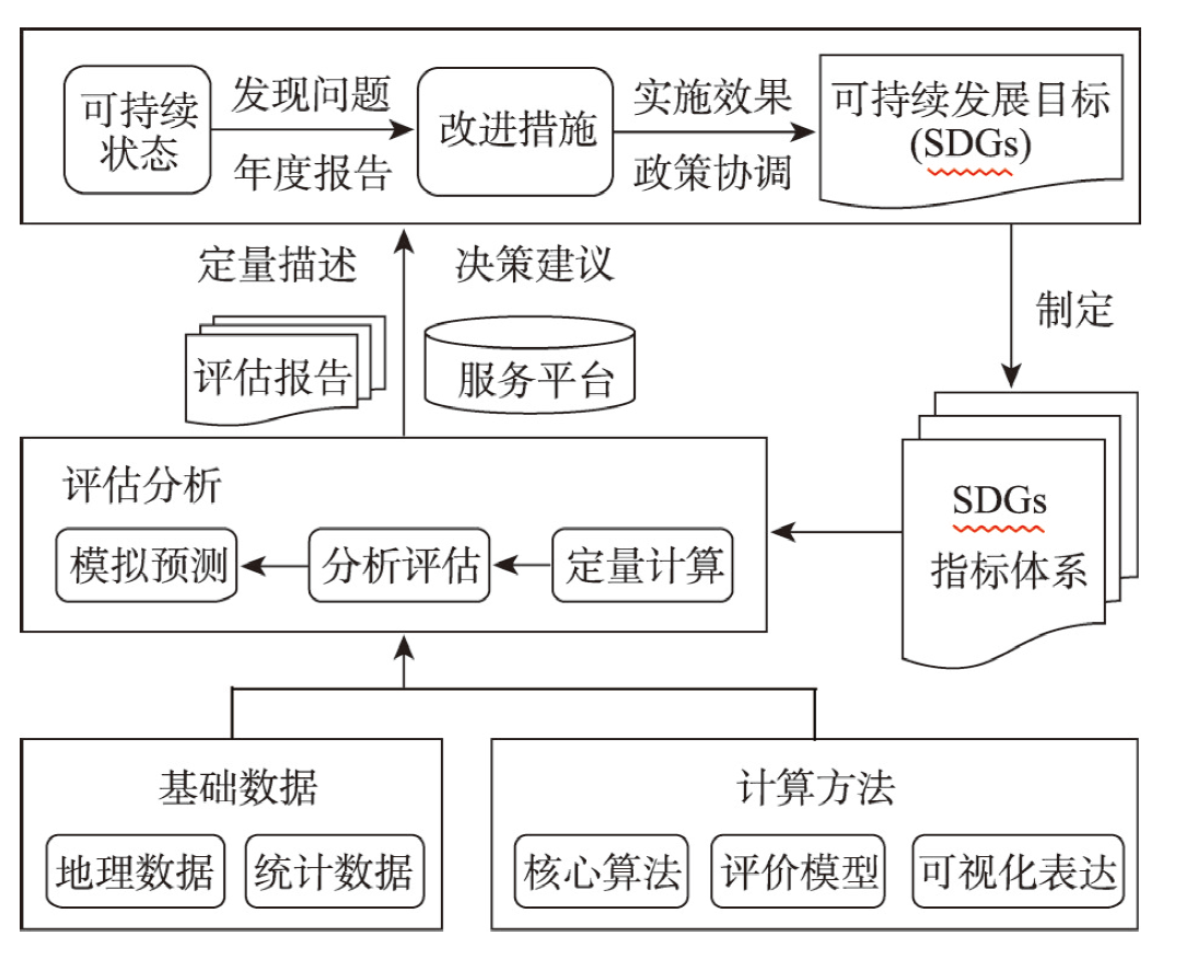
On the basis of analyzing urban SDGs monitoring and evaluation, this paper expounds the conceptual connotation of geospatial enabled monitoring and its differences from traditional statistical-based monitoring for urban SDGs. Meanwhile, through document comparison and analysis, the development and latest progress of urban SDGs monitoring and evaluation has been revealed, suggesting a transformation of urban SDGs monitoring and evaluation from traditional statistical-based monitoring to geospatial enabled monitoring. In addition, this paper systematically analyzes the research progress and current situation of geospatial enabled monitoring from the aspects of monitoring index system, geospatial data acquisition for monitoring, and monitoring ideas and methods. Results showed that the number of urban SDGs indicators is too large and the relationship is complex, with the lack of clear core and key indicators, which need to be optimized and improved according to the specific situation. The lack of standard, public and directly available data requires the development of appropriate methods for spatial data generation and multi-source data utilization, and the establishment of data products for urban SDGs monitoring and evaluation. Besides, the lack of scientific and efficient monitoring and evaluation methods is also one of the main problems facing the current urban SDGs studies. Finally, through the analysis of current challenges in urban SDGs monitoring, future research in geospatial enabled monitoring for urban SDGs are proposed, including the establishment of scientific and efficient monitoring and evaluation methods, the establishment of a standardized and unified monitoring index system, the construction of data production sharing and monitoring and evaluation knowledge service platform, and the strengthening of the application research of big earth data and related disciplines support for the monitoring and evaluation of urban SDGs.
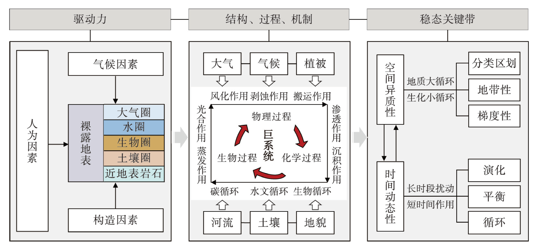
"The Earth's Critical Zone" is a cutting-edge concept proposed in response to the global challenges entailed by sustainable development. Geographers have developed various analytical tools and methods to shed light on the functional structure and dynamic evolution of the global critical zones. However, these analysis methods primarily focus on the perspective of geographical element circulation and material exchange. The intricate interactions between human activities, societal systems, and Earth Critical Zones remain unclear. This article begins by tracing the origins of the Earth's Critical Zone concept before expanding its reach by combining the theoretical knowledge and understanding of human-Earth relations acquired from the regional development experiences of Chinese geographers. In the context of globalization, modernization, and urbanization, the development of human society has become intricately intertwined with the Earth's surface system, involving extensive links based on fundamental mechanisms, interaction patterns, and processes. The concept of the "critical zone of human-earth interaction" is introduced to better comprehend these interactions. A theory with the kernel as "source-flow-confluence" is established for the critical zone of the human-earth interaction concept. The theory of critical zone of human-earth interaction effectively integrates the temporal and spatial processes of the surface of the Earth's natural and humanistic elements in research perspectives. It establishes the link between the intricate operational logic, societal practices, and the existing theoretical framework of the Earth's critical zone. The theory of critical zone of human-earth interaction will help geographers better interpret the development pattern and process of the critical zones. This theory could help the government scientifically formulate spatial, environmental, and social development policies, supporting the high-quality usage of national land resources and the efficient symbiosis of natural and social systems.
Carrying capacity, a concept entrenched in the natural resources and environmental field for nearly two centuries, has continually evolved to address the conflicts and sustainability of the human-nature relationship. This paper introduces an analytical framework for understanding carrying capacity within the context of the human-nature relationship. It systematically reviews the progression of international carrying capacity studies, analyzes global research trends, and compares these with Chinese studies, highlighting key research directions in China. Historically, carrying capacity traces its roots to (neo)Malthusian theories. Its evolution spans four distinct stages: resource carrying capacity (since the 1800s), environmental carrying capacity (since the 1970s), ecosystem carrying capacity (since the 1990s), and natural system carrying capacity (since the 2010s). The concept of carrying capacity varies widely across global disciplines and even within the same discipline, showcasing diverse applications. Carrying capacity has sparked controversy due to its connection to political economy theories and factors such as technological progress, market mechanisms, and spatial and temporal constraints. Therefore, it is imperative to engage in a restrained and explicit discussion and application of carrying capacity. Presently, China's carrying capacity studies align closely with the international community, capitalizing on regional-scale studies employing a holistic and systematic human-nature relationship approach. However, there is an opportunity for enhancement in terms of global-scale perspectives and the integration of natural and social sciences theories and methodologies. This paper proposes fostering innovation and application in carrying capacity research within the Chinese context. This entails integrating various disciplines and theories, exploring scale effects and mechanisms, utilizing model-data fusion and integration, applying case studies in various spatial units and typical zone types, and improving policy systems and institutions.

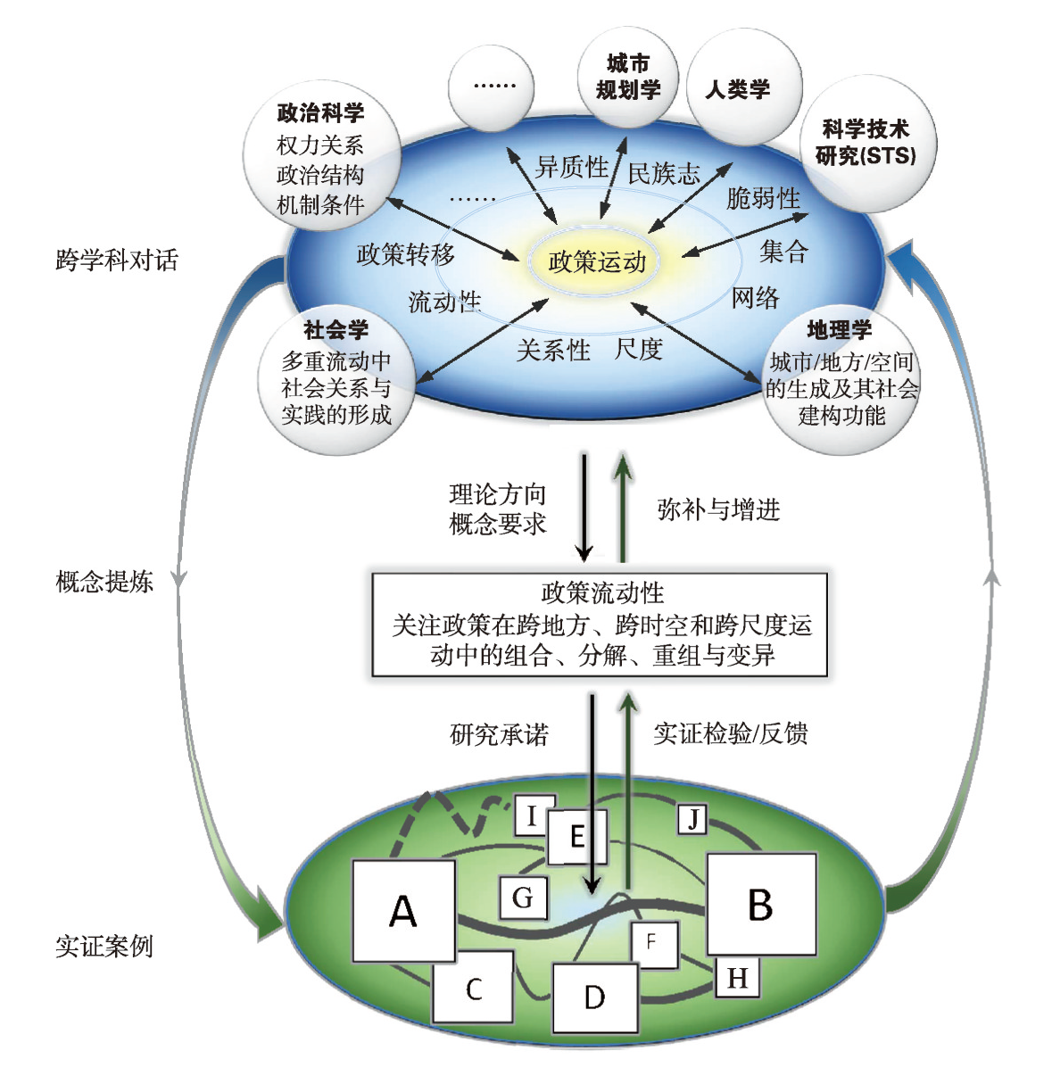
The rise of global neoliberalism and reflexive governance has driven the political flows at the global level. Policy movements thus have shown new dynamics and characteristics. Political science, within the sphere of rational formalism, whose dependence on traditional frameworks, as well as the neglect of geographic mobility in sociology, have limited the explanatory power of existing concepts. The geographical orientation and spatial correlation of policy mobility offer the possibility of a theoretical breakthrough by introducing human geography in the policy research. Based on the literature in geography, this study traces the process of resembling rolling conversation through transdisciplinary research on policy mobility, and further clarifies the conceptual connotations, commitments, and research starting points of policy mobility. As an effective conceptual tool for understanding how policymaking operates, how policy knowledge and models flow, and how these mobilities shape places in the context of neoliberal globalization, policy mobility seeks to clarify the geographic positions, power relations, spatial characteristics, and social and geographical formation processes that are involved in the movements of policies. Policy mobility thus becomes a core field in the social sciences exploring "ideas in motion" and "production of mobilities". In addition, the theoretical orientation and research elements in the study of policy mobility also enhance the explanatory powers of literature from other disciplines to this subject. To a certain extent, this study compensates for the lack of empirical analyses of ideas and knowledge in mobility studies and insufficient research on power theory in human geography. It provides an important research field for applying geography in transdisciplinary research.
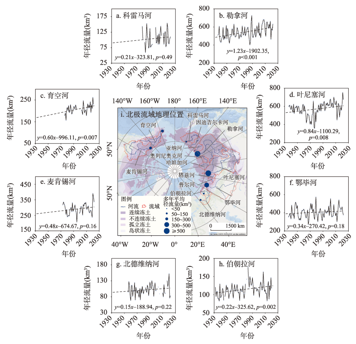
Under the background of rapid global warming, the hydrological regime in the Arctic river basins, where permafrost is widely developed, has changed significantly. These changes not only altered the local ecological environment, but also had far-reaching impacts on the global climate system and socio-economy. Therefore, the study of hydrological processes in Arctic river basins has become a hot-spot issue at the forefront of the international scientific community. Based on a thorough review and critical analysis of domestic and international literature, this paper systematically summarizes the research findings and latest progress on the spatial and temporal changes of the runoff of major Arctic rivers, as well as the driving mechanisms behind these variations. In addition, the patterns and spatiotemporal differences in runoff changes between Eurasia and North America were analyzed in detail. Furthermore, the direct and indirect effects of precipitation changes (e.g., precipitation amount, rain/snowfall fractions) and permafrost degradation on Arctic runoff are thoroughly examined. Despite significant progress in data accumulation and scientific understanding in current Arctic hydrological research, considerable challenges persist, such as the scarcity of ground observations and the difficulty of quantitatively assessing the interactions among climate, snow/permafrost, and hydrological processes. Thus, establishing a robust observation network in the Arctic river basins and developing cold region hydrological models with account for the Arctic specifics are fundamental for gaining in-depth insights into the rapid changes occurring in the Arctic hydrological system. This is also crucial for addressing the risks of water-related disasters and enhancing water resource management in the Arctic region.
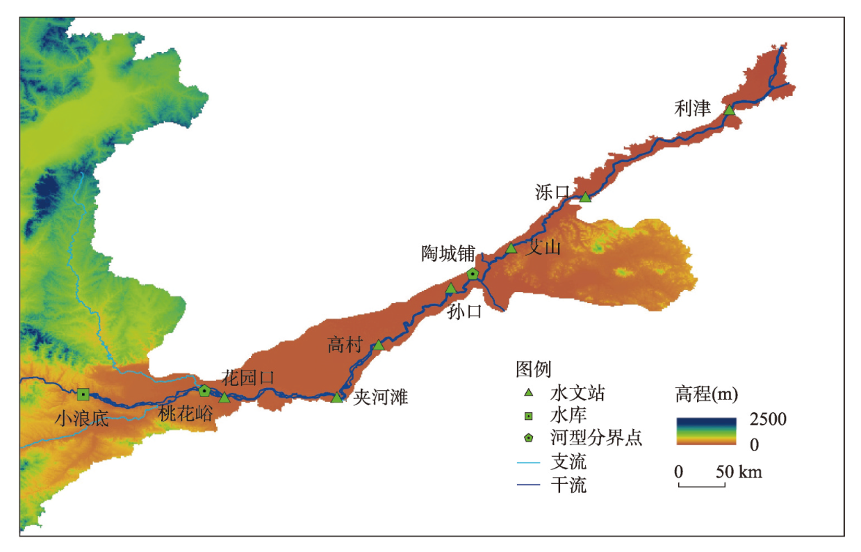
This study focuses on the Lower Yellow River (LYR), which has experienced continuous erosion since the operation of Xiaolangdi Reservoir in 1999, and its complex spatio-temporal variation process. Using the single-step mode of the Delayed Response Model (DRM), we derive a calculation formula for the accumulated erosion and deposition volume in the LYR. The coefficient of determination R2 between the simulated and observed values from 2000 to 2020 is 0.99. Currently, the LYR is undergoing continuous erosion, but the erosion rate is gradually slowing down, and the difference between the equilibrium value and the calculated value of accumulated erosion and deposition volume gradually decreases, which means that the riverbed erosion is approaching equilibrium. Additionally, we derive a formula for the spatial distribution of main channel accumulated erosion volume per unit river length in the LYR based on the non-equilibrium suspended sediment transport equation. The coefficient of determination between the fitted value and observed value from 2003 to 2015 is about 0.98-0.99, with a relative error of approximately 6.2%. Our findings suggest that under the current conditions of decreasing sediment inflow and continuous scouring, it takes around 3.0 years for the riverbed to achieve half of the erosion and deposition adjustment and approximately 13.0 years to achieve 95% of the adjustment. Moreover, the spatial distribution of accumulated erosion volume in the LYR tends to become more uniform with the continuous development of erosion. These results provide valuable reference for analyzing the complex spatio-temporal variation process of the LYR.
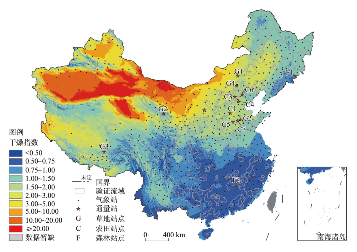
Evapotranspiration (ET) is one of the key components of the terrestrial water cycle, and its long-term changes directly affect the spatiotemporal pattern of regional water availability. In recent decades, China has experienced significant changes in climate and land surface characteristics. However, how these changes affected the spatiotemporal pattern of terrestrial ET was still poorly understood. In this study, we quantified the contributions of five factors related to climate and vegetation (precipitation, wind speed, vapor pressure deficit, net radiation, and leaf area index) to ET trends across China using the Penman-Monteith-Leuning model and a forcing variable detrending experiment. The results showed that nationwide annual ET increased significantly (p < 0.05) from 1982 to 2019, with a trend of 1.25 mm a-1. Vapor pressure deficit, leaf area index and precipitation dominated the national ET changes, and their contributions to ET trends are 42% (0.54 mm a-1), 29% (0.36 mm a-1), and 27% (0.31 mm a-1), respectively. Spatially, the dominant factors of ET changes show clear regional differences. Changes in ET are dominated by precipitation in the arid and semi-arid regions of northwestern China, and by vapor pressure deficit in humid regions such as the Yangtze River basin and the northern part of northeastern China. Leaf area index dominates ET changes in areas with a significant greening such as the Loess Plateau, North China Plain and parts of Northeast China. The findings are expected to provide guidance for national water resources management and planning under climate change.
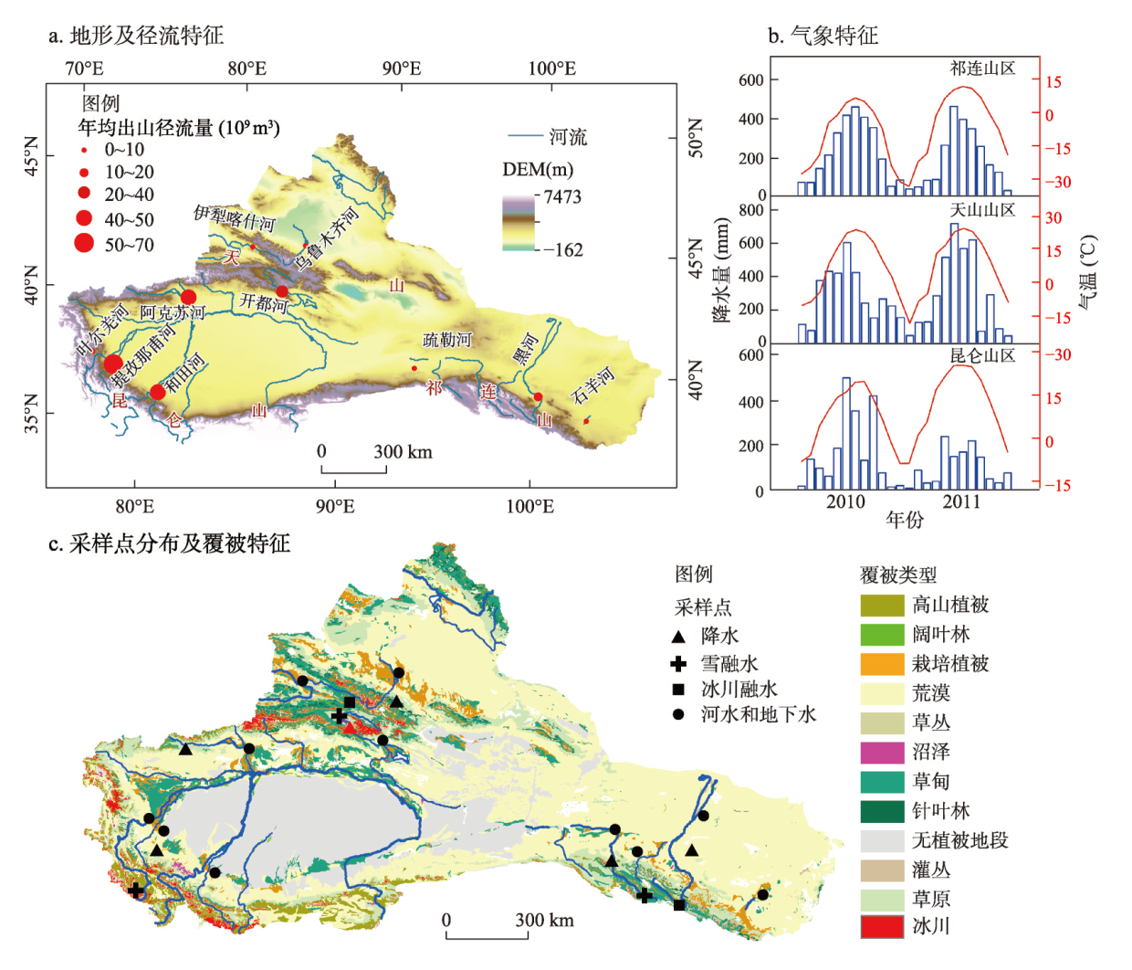
As an important strategic resource in the arid inland region of Northwest China, water resources are related to the sustainable development of the regional economy and society. As important regional water resources, inland river basins are highly sensitive to global climate change. In this study, we studied the typical inland river basins in the Qilian Mountains, Tianshan Mountains, and Kunlun Mountains. The regional runoff composition and its relationships with the main environmental factors were analyzed based on long-term runoff monitoring and water chemical isotope analysis data of precipitation, meltwater, river water, groundwater, and other water bodies. The results showed that: (1) Except for the Shiyang River, the annual runoff of most rivers in the study area showed an upward trend in recent decades; (2) Most of the water bodies in the study area were alkaline, and the dominant anion and cation of each water body were HCO3-, and Ca2+ and Na+, respectively. The hydrochemical type was mostly HCO3--Ca2+, which is strongly affected by rock weathering. The TDS of river water showed a similar seasonal trend, being low in summer and autumn, but high in winter and spring. Meanwhile, the seasonal differences of each ion are relatively prominent. (3) Except for the Hutubi River, the variation trend for δ18O was relatively consistent, showing the seasonal variation of low in summer and autumn while high in winter and spring throughout the year. (4) The average annual contributions of groundwater, precipitation, and glacier/snow meltwater to regional streamflow in the study area were 42.6%, 34.4%, and 23.0%, respectively, with spatial heterogeneity in regional runoff composition. (5) In the context of climate change, regional temperature variability will increase the risk of runoff changes in the Aksu, Hotan, and Shiyang rivers, whereas fluctuations in precipitation may pose potential risks to runoff processes in the Tizinafu and Shule river basins, and there are potential water quality risks in the Hotan River. The results of this study have strong implications for the sustainable use of regional water resources.
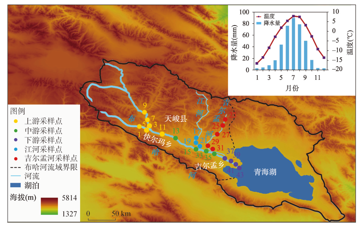
Sedimentary DNA has been widely used in the studies of climate change, ecological function, and environmental archaeology, because it can provide biological dynamic information with temporal dimension in geographical environment. However, the surface processes and impact factors of sedimentary DNA within the catchments are still not fully understood, which limits the accuracy of sedimentary DNA data interpretation. In this study, topsoil DNA concentrations at the Buha River catchment in northwest Qinghai Lake, which was suitable for DNA preservation, were firstly measured based on domestic new sedimentary DNA laboratory. Meanwhile, soil physical and chemical compositions, including grain size, elements, loss on ignition and TOC, were determined. Subsequently, the abiotic factors which had impact on spatial distribution of topsoil DNA concentration were analyzed by combing the status related with climate, vegetation cover, and land use at the Buha River catchment. The results showed that the average concentration of topsoil DNA at the whole catchment was 0.91 μg/g, with the higher values in the middle reaches of the Buha River and its tributary Jilmon River, while the lower ones in the lower reaches near the Qinghai Lake. In addition, topsoil DNA concentrations at the catchment were positively correlated with the contents of clay and organic matter, but negatively correlated with sand content and the intensity of weathering and leaching. Besides, high vegetation cover and frequent grazing activities contributed to the enrichment of the topsoil DNA, while strong weathering and leaching under warm and wet environment, river transportation and crop cultivation reduced the concentration of the topsoil DNA. All the above results provide a scientific basis for an understanding of the deposition processes of sedimentary DNA and their impact factors in the Buha River catchment, which are helpful for revealing sedimentary DNA compositions and evolution processes of ecological environment and human-environment relationship in regions west of the Qinghai Lake.
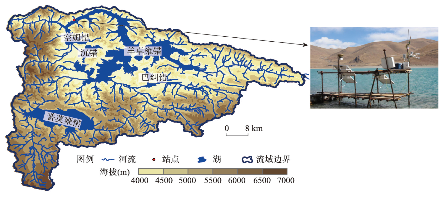
Lake surface water-heat exchange and its climatic attribution critically influence the evaporation mechanism and water balance in alpine lakes in a warming climate. Based on the eddy covariance turbulent flux observation of Yamzhog Yumco, an alpine lake in Tibet, this paper explored the characteristics of the hourly, daily, and monthly variations of the lake surface water-heat flux and their correlations with meteorological factors during the non-freezing period in 2016 and 2017. We found that the average latent heat flux was much higher than the sensible heat flux on the lake surface from April to December. Moreover, the water-heat flux exhibited remarkable seasonal variation, and the higher air temperature and humidity in summer jointly controlled the lake-air energy exchange over the lake surface. First, the lake-air temperature difference was the most significant meteorological factor related to sensible heat flux on half-hourly, daily, and monthly scales. Second, the latent heat flux was strongly positively correlated with wind speed and the synergies of wind speed and water vapor pressure deficit on the daily and half-hourly scales. Third, the lake surface water-heat flux was significantly negatively correlated with the net radiation flux on the daily and monthly scales, which was attributed to the seasonal variation of the water surface net radiation and the phase difference of the water-heat flux intensity change due to the lake-air temperature difference and heat capacity contrast. The results revealed the differences of the main controlling meteorological factors in the variation of water-heat flux in the alpine lakes in south Tibet on different timescales. The work will hopefully improve our understanding of the mechanisms of energy exchange and evaporation over alpine lakes in the future projected climate conditions.
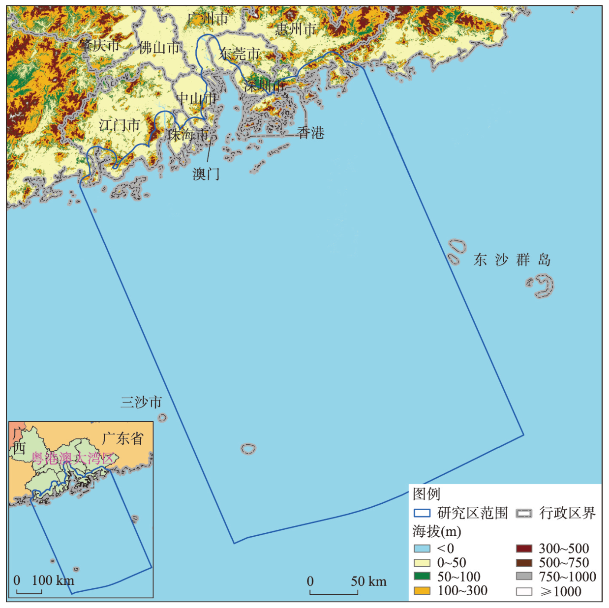
This paper aims to introduce the concept of spatial scene and a novel ecological carrying capacity (ECC) and sustainability assessment framework for coastal and maritime area (CMA) coupling three-dimensional (3D) EF model and spatial scene. Spatiotemporal changes of spatial scenes, ECC and sustainability in the CMA of Guangdong-Hong Kong-Macao Greater Bay Area (GBA) from 1990 to 2019 were assessed and analyzed using the framework mentioned above. The results showed that: (1) In the past 30 years, the loss of forests and paddy land dominated the spatial scene conversions in the GBA coastal land and intertidal zones, which were mainly converted to scenes of mariculture, residential area, commerce, industrial production, roads, etc. Meanwhile, the reduction of reserved sea and marine capture played a key role in the GBA marine areas, which were primarily transformed into scenes of marine protection, mariculture, tourism-entertainment sea, port-shipping and industrial-urban sea. (2) The total ECC of the study area increased at first and decreased later, representing an upward trend on the whole, which were also the same variation trends that occurred in most spatial scenes. Nevertheless, the per capita ECC decreased continuously. (3) The per capita EF depth of the study area and most of the spatial scenes has continued to rise and all values exceeded the original value of 1, revealing the unsustainable development trend; whereas the per capita 3D EF showed a rapid upswing at first and then a gradual increase pattern. The highest annual average per capita EF depth existed in the scenes of dryland, land traffic station, and industrial production, while the per capita 3D EF in forests, industrial production, and land traffic station increased fastest. (4) With the recent industrial transformation and upgrading, as well as the adjustments and optimization of marine policies, the unsustainable development trend of the study area over the 30 years has been effectively alleviated. These findings clearly demonstrate that spatial scene is more capable than traditional land use/cover of accurately reflecting the sustainability differences caused by human activities in the CMA, reflecting the advancement and effectiveness of our spatial scenes-based sustainability framework.
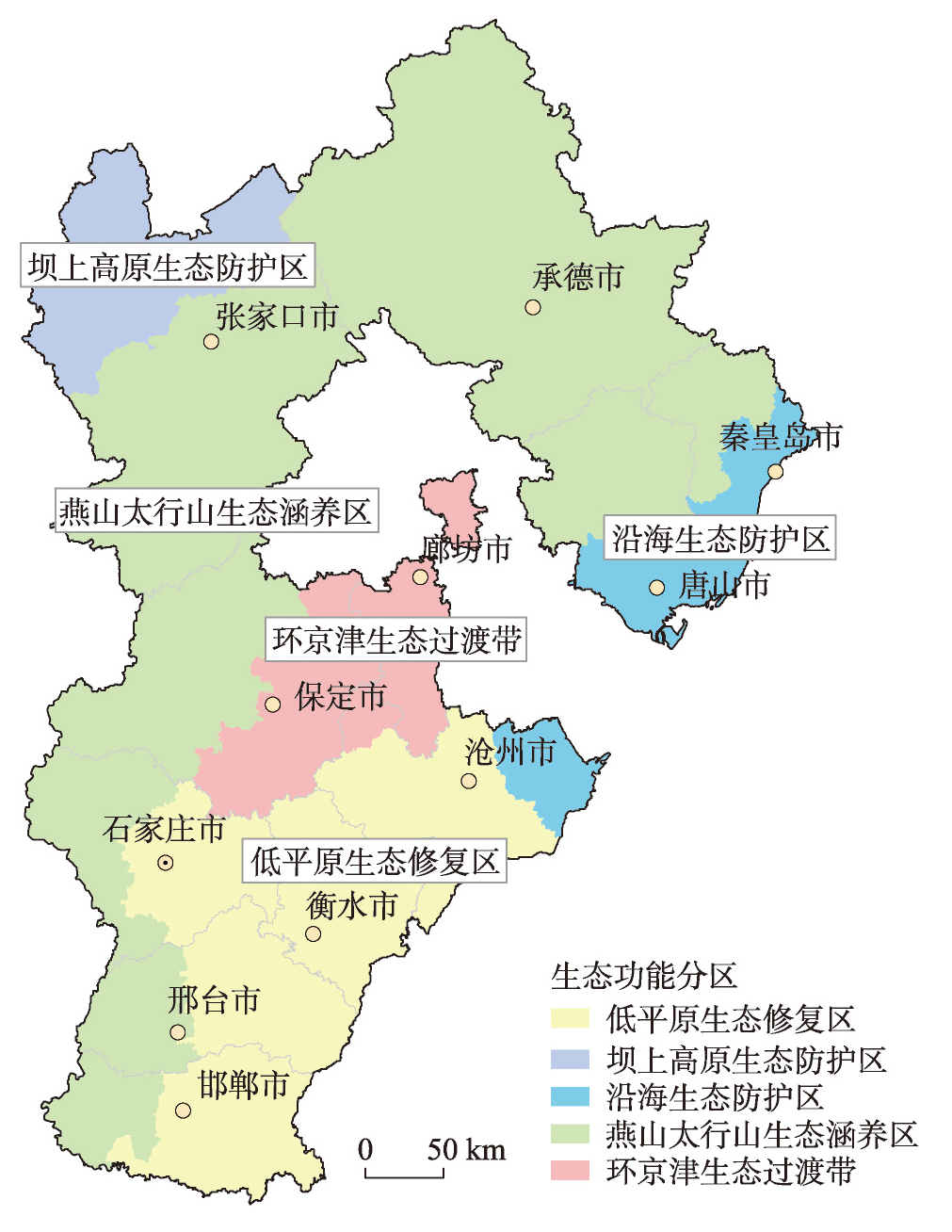
The trade-off and synergy analysis of ecosystem services is a hot topic in current research on ecosystem services, which can provide scientific basis for ecosystem management. Based on ecological functional areas in Hebei province, this study evaluated the value of four ecosystem services, including food production, carbon storage, soil conservation and water conservation. Then the trade-off and synergy of ecosystem services in different ecological functional areas were analyzed through the spatial overlay method. The results showed that the total grain production in Hebei province was 38.28 million tons in 2017, and the contribution ranking of the five major ecological areas is Low Plain Ecological Restoration Area (PY) > Yanshan and Taihang Mountains Ecological Conservation Area (YS) > Surrounding Beijing and Tianjin Ecological Transition Zone (HJJ) > Bashang Plateau Ecological Protection Zone (BS)> Coastal Ecological Protection Zone (YH). The total amount of carbon storage, soil conservation, and water conservation services in Hebei was 85.7 million tons of carbon, 4701.61 million tons of soil, and 6568.75 million tons of water, respectively. These three services exhibit a similar spatial pattern, with the contribution of Yanshan and Taihang Mountains Ecological Conservation Area was the highest, while the contribution of other ecological functional areas was generally lower. Strong trade-offs and low synergies among different ecosystem services were the main relationship. The area proportions of strong trade-offs, low synergies, weak trade-offs, and high synergies were 48.15%, 45.92%, 5.09%, and 0.83%, respectively. The dominant function of strong trade-offs in ecosystems was basically consistent with the functional positioning of the ecological zone where it is located, which can provide basis for the better play of the dominant function of the ecological functional zone. This study can provide new ideas for managers to optimize the trade-off and synergy effects of ecosystem services from the perspective of ecological functional zones.
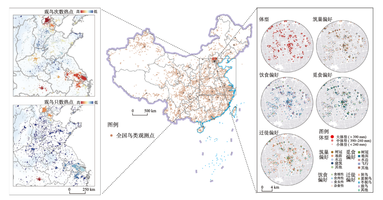
Bird diversity is facing a considerable threat. The existing studies primarily focus on local or regional scales by relying on categorical variables to classify birds' urban tolerance. However, they tend to neglect the evolutionary relationship between species, leading to inconsistent and sometimes contradictory conclusions regarding the response of bird traits to urbanization. Therefore, our study attempts to supplement the previous literature by using the above deficiencies as bases. We integrate 952,036 citizen science observations of birds in China from 2012 to 2020, along with various continuous measures of urbanization, such as the proportion of built-up land, population density, and night-light intensity. From a phylogenetic perspective, we explore the urbanization response and tolerance of Chinese birds on national, regional, and urban scales. Our findings reveal that birds with large clutch sizes and generalist diets are the most adaptable in the urban environment. Moreover, phylogenetic and non-phylogenetic analyses present inconsistencies, indicating that the evolutionary relationship between species conceals the expression of several traits in urban tolerance. Birds that nest on architectural cliffs show high urban tolerance within clades. In addition, the decisive factors influencing birds' tolerance to urbanization vary across different latitudes. High-foraging birds perform well in high-latitude urban environments, whereas insectivorous birds exhibit high urban tolerance in mid-latitude areas. Migratory birds show strong adaptation to urban environments at low latitudes. The above results confirm the importance of considering species evolution and diverse continuous urban measurement in studying the relationship between various birds and urbanization. This approach helps us adopt differentiated protection strategies for birds in the context of rapid urbanization. Several measures can be implemented to mitigate the adverse impact of rapid urbanization on birds and promote harmonious urban design. They include protecting the existing trees and buildings that serve as nesting sites for birds, increasing the presence of shrubs to provide suitable habitats for ground-dwelling bird species, and implementing strategies to control predation risks for ground nests. These efforts contribute to optimizing urban spaces and creating a favorable environment for bird populations.
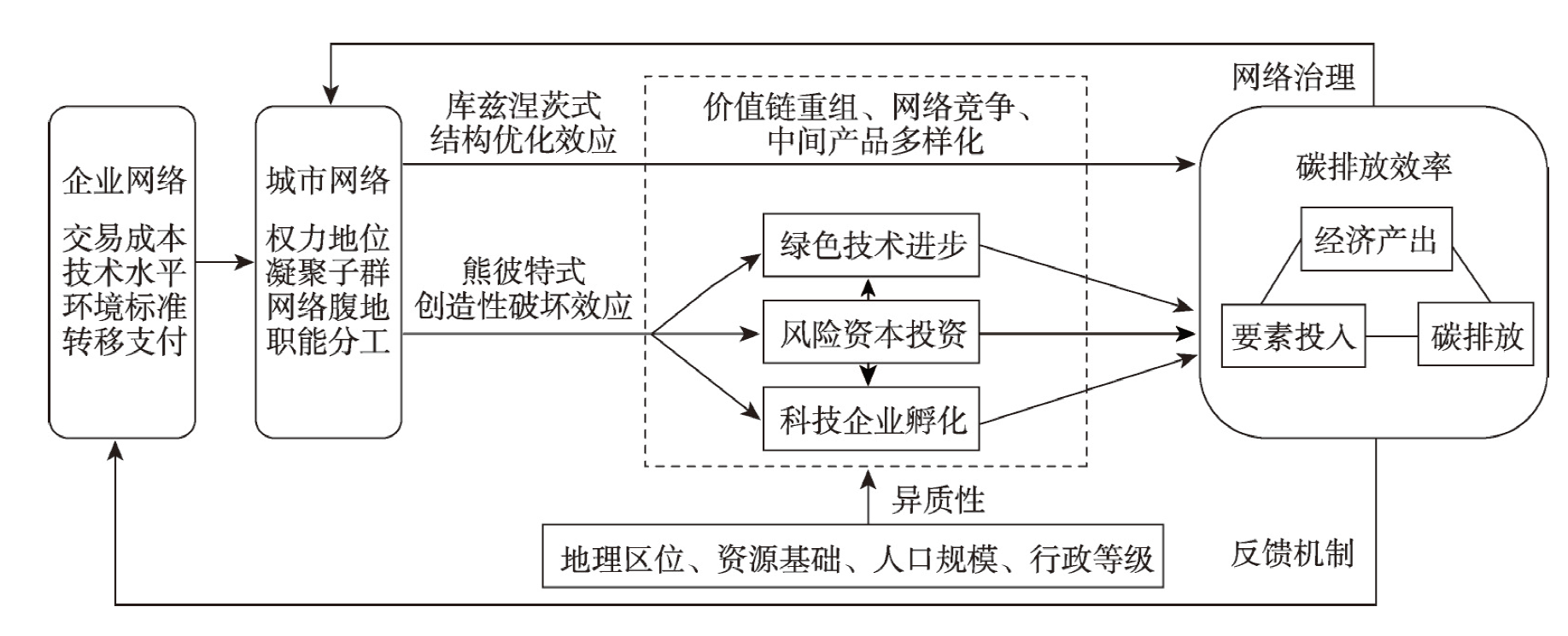
Improving the urban carbon emissions efficiency (UCEE) is the key for China to achieving carbon peaking and carbon neutrality goals and enhancing sustainable development capabilities. In recent years, increased attention has been given to the role of city network economies in promoting factor productivity and economic growth. However, it is still unknown whether network position of cities translates into a higher level of UCEE. This paper sets out to explore the impact of network position on UCEE through the lens of investment networks of China's top 500 manufacturing enterprises. To this end, the Window model and super-efficient SBM model in data envelopment analysis (DEA) are combined to measure the total factor carbon emissions efficiency of cities. In addition, a set of panel Tobit models are employed to assess the positive influence, transmission channels and multidimensional heterogeneity of cities' network position. The analysis finds that: (1) Network position has a significant positive impact on UCEE. The conclusion is still valid considering the replacement of carbon emissions efficiency measurement methods, spatial autocorrelation effects, and endogeneity issues. This result confirms that network linkages provide a basis for cities to balance economic growth and carbon emissions reduction on a larger spatial scale. (2) Two types of effects through which network position enhances UCEE are identified. On the one hand, network position exerts a direct effect through value chain reorganization, intermediate product diversification and network competition. On the other hand, green knowledge innovation, technology-based enterprise incubation and venture capital investment play mediation roles between network position and UCEE. (3) The influence of network position on UCEE is heterogeneous. The carbon emissions efficiency of eastern cities, non-resource-based cities, cities with larger population size and cities with higher administrative rank benefit more from the enhancement of network position. This indicates that network linkages have increased the inter-city gaps of carbon emissions efficiency in China on different dimensions over the past 20 years. The paper provides important implications for policymakers. In the future, the Chinese government should combine the "dual carbon" goal with the construction of city networks, and give full play to the role of network economies in promoting UCEE. Besides, great efforts should also be made to narrow the multidimensional UCEE gaps to achieve a balanced low-carbon society.
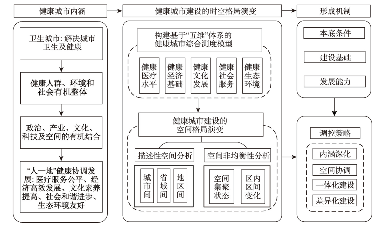
The health of the people is an important indicator of national prosperity and strength. The "Healthy China 2019-2030" initiative emphasizes the need to firmly establish the concept of "health and hygiene", with the government, the public, and individuals working together to promote a lifestyle, ecological environment, and social environment conducive to good health. Building upon this, this study explores the fundamental aspects of a healthy city from a geographical perspective and develops a comprehensive evaluation system that integrates a "five-dimensional" framework for the construction of a healthy city. The research focuses on 341 prefecture-level units in China and investigates the spatiotemporal heterogeneity and formation mechanisms of healthy city construction in the country. The findings indicate the following: (1) The overall level of healthy city construction in China is on the rise. The average comprehensive health index for the years 2010, 2015, and 2020 was 0.367, 0.402, and 0.438, respectively, exhibiting a layout characteristic of higher development level along the coastal regions and lower development level in the inland areas, as well as higher level in the eastern part compared to the western part. Various prefecture-level units exhibit regional disparities across five dimensions, including medical services, economic foundations, cultural development, social services, and ecological environment, resulting in diverse spatial patterns. (2) Healthy city construction in China demonstrates significant overall spatial autocorrelation, revealing a spatial distribution pattern characterized by warmer development in the eastern and coastal regions and cooler development in the western and inland regions. The overall regional disparities in healthy city construction follow a trend of initial increase followed by a decrease, indicating a gradual shift towards coordinated regional development. (3) The natural environment, human activities, construction foundations, and development capabilities serve as fundamental, intrinsic driving, and external promoting factors, respectively, influencing the spatial patterns of healthy city construction. Factors such as per capita GDP, average elevation, population density, and transportation accessibility have a substantial impact on the spatial patterns of healthy city construction. This study, from a geographical perspective with a focus on the "human-land relationship", elucidates the five-dimensional framework of healthy city construction and provides a clear path for healthy city development in China. It offers a scientific foundation for the comprehensive promotion of healthy city construction and supports the implementation of the Healthy China strategy.