At present, the empirical analysis of regional dual-nuclei structures at the national level is still relatively rare. How to define the provinces with the characteristics of dual-nuclei structures and analyze their impact needs further empirical discussion. In this paper, the spatial Dubin model and the data of 259 prefecture-level cities are used to analyze the distribution characteristics of regional dual-nuclei structure in China and its influence on provincial development. The empirical results show that 11 provincial-level regions (hereafter provinces) in China show the characteristics of dual-nuclei structure. The regional dual-nuclei structure plays a significant role in promoting the economic development of the province, but the northern and southern regions show great differences. The regional dual-nuclei structure has a promoting effect on provincial industrial agglomeration and helps to promote the improvement of local scientific and technological innovation. In general, compared with some single-core provinces with small scale and weak radiation driving force in some provincial capitals, the regional dual-nuclei structure can make up for these shortcomings to a certain extent by virtue of the number of central cities and spatial distribution, which is more conducive to driving local economic development and scientific and technological innovation.
Regional economic resilience is closely related to the state of the regional industrial structure. During the process of the region undergoing and recovering from external shocks, whether and how the spatio-temporal correlation between economic resilience and the evolution of the established industrial structure should be further explored. The micro and mesoscopic views of enterprises and industries, multi-year economic growth data, and enterprise status in the counties of the Beijing-Tianjin-Hebei region were employed to measure regional economic resilience at the county level and divide its economic development stages. In addition, a spatio-temporal correlation between regional economic resilience and industrial structure was appropriately tested, and the main industries affecting regional economic resilience were distinguished. Finally, the coupling mechanism of regional economic resilience and industrial structure evolution was analyzed. The major findings are as follows: (1) The periods of rapid and slow economic growth occur alternately in the study region, and the economic resilience shows a fluctuating growth trend. Meanwhile, central urban areas such as Beijing, Tianjin, and Shijiazhuang exhibited high economic resilience, and a typical center-periphery structure gradually took shape. (2) There was a significant spatial correlation between regional economic resilience and industrial structure. In economically developed regions, such as Beijing and Tianjin, the agglomeration of high economic resilience and high industrial structure was evident. There was a two-way causal correlation and consistency in time-series changes. (3) The industrial structure in the Beijing-Tianjin-Hebei region had gradually improved. Compared to the effect of industrial structure, the effect of competitiveness contributed more to economic resilience. Primary industries as well as those pertinent to consumer services and social services have played a pivotal role in improving regional resisting economic resilience. Besides, the development of consumer services and social services leads to the strengthening of the region's recovering economic resilience. (4) The evolution of the industrial structure achieved the evolution of the development path, which was revealed in the distinction of economic resilience at the county level. In addition, the coupling correlation between regional economic resilience and the evolution of industrial structure in the study region was mainly revealed in the time scale, which had not yet led to the fundamental restructuring of the regional spatial structure, and the center-periphery structure is still relatively significant.
Rural area has abundant ecological resources. Ecological industrialization has become the emerging trends in rural areas and the new driving forces for rural revitalization. This study summarized the evolution of China's ecological environmental policies, and clarified the promotion mechanisms of regional ecological industrialization development to rural revitalization from the perspectives of ecosystem and human society, ecological products and economic development, ecological industrialization and rural revitalization, and discussed the models and pathways of poverty alleviation and rural revitalization by developing modern organic industry based on the regional ecological resources from the case study of Yangxian county in southern Shaanxi province. Three stages of China's ecological environmental policies were summarized, including "Focus on economy and light on environmental protection", "Environmental protection and scientific development" and "ecological civilization construction". Relationship between natural ecosystem and human social welfare reflects the objective needs of social and economic development and subjective initiative of human utilization of nature. The crucial ecological products and economic development was the engine of "nature-ecology-society-economy" in the core of benefits. The core of ecological industrialization and rural revitalization is the guarantee mechanism of "human-land-industry-right". Organic industry development is the typical model and important direction of ecological industrialization. In Yangxian county, the organic production paradigm of "product-industry-production area" promotes the transformation of organic practitioners from single subject management to multi-agent operation, and the transformation of land use type from resource optimal allocation to man-land coordination. In the future, coupling of ecological protection and socio-economic development can be realized by the model construction of modern organic agriculture and rural revitalization in Hanjiang River basin from the aspects of improving organic products quality and yield, enhancing organic industrial integration and value, reducing consumption and increasing efficiency in production areas.

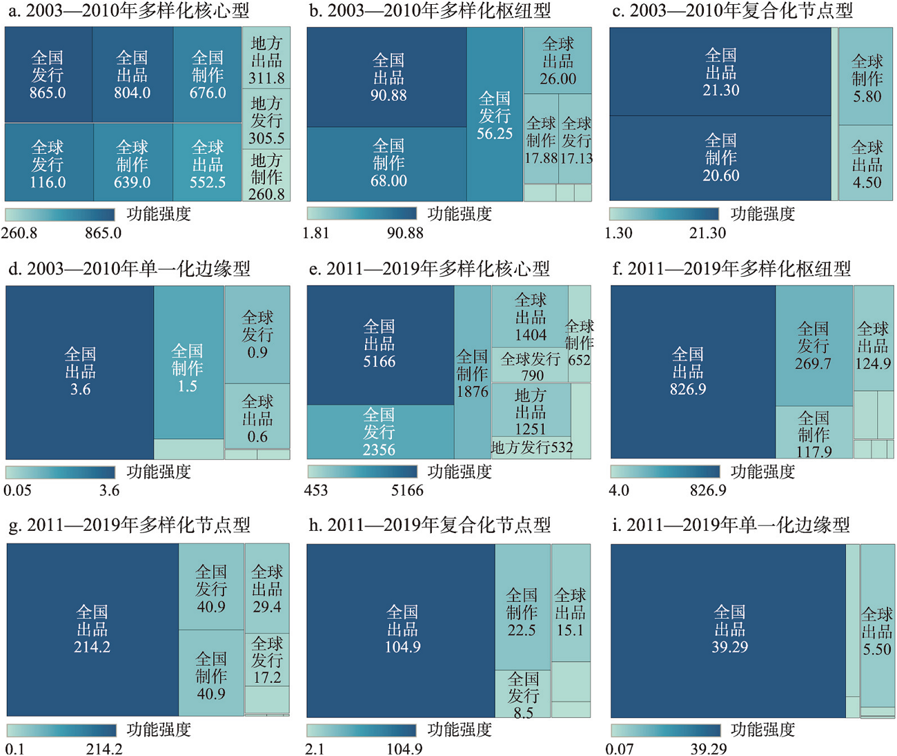
Exploring the functional status and correlation effects of a city in the cross-scale networks has significant implications for enhancing its urban functions. In this paper, Chinese films whose revenue accounted for over 75% of value of the total box office revenue during the period 2003-2019 were selected as research samples. Then, the functional differentiation of cities in cross-scale networks encompassing the levels of local, national, and global significance, as well as the evolutionary characteristics of cross-scale network functional correlations among different types of cities, was explored based on film industry chains. The results showed that: (1) A significant urban functional differentiation, characterized as five types, was shown in the multi-scale networks of industrial chains, namely diversified core cities, diversified hub cities, diversified node cities, hybrid node cities, and singular peripheral cities. (2) Cities exhibited dynamic correlation effects among cross-scale network functions, with variations in urban functional types and industrial chain segments. Generally, this result would be more significant in cities with comprehensive scale functions and diverse industrial chain functions compared to those with relatively singular functions. (3) Diversified core and hub cities exhibited significant correlation effects across various segments, with differentiation in significance and correlation degree influenced by the network structure and externalities of each segment. Under financial impetus, the production segment served as the primary channel for diversified node and hybrid node cities to gradually enhance their enterprise concentration, thereby gaining limited benefits through network externalities. However, lower enterprise concentration levels and limited interactions of intra-city industrial chains failed to promote their integration into external networking. Singular peripheral cities, characterized by a low development level and a sole focus in scale function and industrial chain function, did not exhibit significant correlation effects.
The paper builds a framework for analyzing the determinants of the scale of enterprises, including city attributes and firm attributes, from the perspective of internal and external economies of scale jointly determining enterprise scale. Based on the understanding of the scale and structure of the local labor market, we take Japanese multinational enterprises (JMEs) in the Bohai Sea Rim region as the research object. This paper focuses on the shared labor force and dedicated labor force to establish multiple regression decision models, and to analyze the determinants of the scale of JMEs and its spatial and temporal changes. The results show that: (1)The scale of the local labor force and the shared labor force have an inhibiting effect on the scale of JMEs, and the scale of the dedicated labor force has an expansionary effect on the scale of the enterprise. (2) The scale of the local labor force has a significant and robust inhibition effect on the scale of JMEs during the studied period. The inhibition effect of the scale of the shared labor force on the scale of JMEs is only significant after 2001, while the expansion effect of the scale of the dedicated labor force on the scale of JMEs is significant before 2001. Over time, the weakening of the expansion effect of the dedicated labor force and the strengthening of the inhibition effect of the shared labor force have jointly affected the shrinking scale of JMEs. (3) Among the enterprise attributes, enterprise age has an expansion effect on the scale of JMEs, while sole proprietorship entry and service-oriented industry have a significant and robust inhibiting effect on the scale of JMEs. The number of local development zones is the most important city attribute and has a significant expansion effect on the scale of JMEs. The expansion effect of local enterprise agglomeration on JMEs is most pronounced in Shandong province, but insignificant in the model of the dedicated labor force, and tends to strengthen in the models of the local labor force and the general labor force in the Bohai Sea Rim region.
A comprehensive understanding of the connectivity of the Belt and Road trade network and the scientific identification of critical nodes in the Belt and Road trade cooperation are crucial for China to effectively promote the high-quality development of the Belt and Road Initiative (BRI). From the perspective of network connectivity, this paper proposes the concept of "gateway country", and integrates the frontier methods of network analysis, including Top network, community detection, and gateway coefficient, to examine the evolution of the spatiotemporal patterns of the Belt and Road trade network, analyses the structural changes of trade blocs and identifies trade gateway countries and their functional roles, intending to develop foreign trade and economic cooperation and promote the Belt and Road construction in China. The results show that: (1) The trade volumes of the BRI countries have continued to grow, gradually forming trade network patterns with increasingly close ties, complex structures and significant hierarchical features. (2) The core nodes of the BRI backbone network are prominent, and the polarisation effect is significant, evolving from "relative equilibrium" to "superpower dominant", with China becoming the leading force in the whole trade network. (3) Against the globalisation and regionalisation interaction background, the BRI trade network has formed four to five communities. The community structures exhibit geographical proximity and instability in the number of communities, their scale and membership composition in different years. (4) China, Russia, India, Turkiye, Singapore, Malaysia, Poland, Hungary, Romania, Egypt, Israel, and Lebanon have become gateway countries along the Belt and Road, either as major trading countries or as hub countries with unique geographical locations. As functional nodes and strategic hubs that consolidate and maintain the Belt and Road trading system, the gateway countries play crucial roles in promoting the trade network connectivity and should be a priority strategic choice for China's economic and trade cooperation with the BRI countries.
Knowledge exchange at international academic conferences is an important function emerging from the globalization of science and technology and the evolution of global innovation networks, and its spatio-temporal complexity has become an emerging theme in human economic geography. The spatio-temporal evolution pattern of knowledge exchange at global academic conferences from 2000 to 2019 and its affecting elements are depicted from spatio-temporal multiple scales by integrating big data mining, mathematical statistics, GIS spatial analysis, and spatial measurement methods. The research found that: Firstly, the knowledge exchange at global academic conferences follows the "downturn-recovery-boom-decline" mid-cycle pattern, and the inter-month variation forms a double-peak structure in June and September; the knowledge exchange fields are concentrated in the "Pasteur Quadrant," and application-oriented basic research like computer science, electrical & electronic engineering, control science, materials science, and communication science becomes the core frontier in these fields. Secondly, the exchange of academic conferences globally takes the form of a polycentric structure with three hubs, numerous sub-centers, and clusters concentrating in North America, Western Europe, and East and Southeast Asia. This structure demonstrates a duality of path locking and path creation, adhering to the law of "resource-economy" oriented location selection. Thirdly, different levels of knowledge exchange at global academic conferences cities are developing, and the knowledge exchange fields are heavily concentrated in the three major disciplines of computer science, electrical & electronic engineering, and physics. These three disciplines converge with the global "turn to applied science," and there is also significant heterogeneity in the type of "the scale concentration and disciplinary dominance" relationship in these cities. Finally, there are notable differences in the drivers of knowledge exchange at global academic conferences between cities in developed and developing countries, with the knowledge exchange at global academic conferences not only being closely related to its embeddedness but also being fueled by a combination of improved exchange environments, lower exchange costs, and increased academic prestige.

Resilience study has long been a focal point in various fields of geography, social science, urban studies, and psychology. Recently, resilience study from multiple disciplines has scrutinized at individual scale. As an important behavior in daily life of human beings, travel behavior is of spatial dependence, spatio-temporal dynamics, and individual heterogeneity. Moreover, how to understand interaction between travel behavior (demand) and traffic supply and their dynamics is a fundamental question in transport studies when transport systems encounter unexpected disturbance. Based on fundamental theories from multiple disciplines including ecology, traffic engineering, and psychology, this paper refines the definition of travel behavior resilience. Also, this paper proposes a conceptual theoretical framework of travel behavior resilience based on dynamic equilibrium characteristics of traffic supply and demand. In general, travel behavior presents three stages of variations, namely, dramatic reduction, rapid growth, and fluctuation recovery, which has been helpful to capture travel behavior resilience triangle. Then we construct a corresponding evaluation methodology, which is suitable for multi-scale and multi-dimensional perspectives. We emphasize that the evaluation of travel behavior resilience should be process-oriented with temporal continuity or capture inflection points of travel behavior. Using multi-source big data such as mobile phone signaling data and smart card data, this paper offers empirical studies on travel behavior resilience, and explores its spatial heterogeneity and group differences. With the location-based analysis, we confirm that people show the greater travel behavior resilience at places where people are engaged in various socio-economic activities. With the group-based analysis, we find that age, socio-economic attributes of mobility groups significantly affect travel behavior resilience. Overall, travel behavior resilience can be one pillar and also offer geographic perspectives to broaden resilience studies. In future, the study of travel behavior resilience on multiple scales and perspectives can explore spatial heterogeneity of traffic re-equilibrium, transport modal differences, and then contribute to urban spatial structure studies. Indeed, the study of travel behavior resilience can provide scientific and technological support for urban management and resilient city construction.
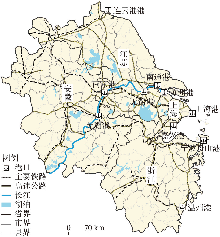
Globalization and containerization have strengthened the connection between seaports and inland areas. Competing for the distant hinterland of ports, instead of being limited to the local hinterland, has become one of the vital paths to enhance port competitiveness under port regionalization. This study uses the weighted field strength model and liner contact data to simultaneously identify and analyze the evolution processes of the local hinterland, monopolistic distant hinterland, and competitive distant hinterland of 10 main container ports in the Yangtze River Delta in 2006, 2012, and 2019. The research findings show the characteristics of the port hinterland in the port regionalization stage as follows: (1) The local hinterland is still one of the focus points of the container inland port and seaport competition. During the study period, the expansion and contraction of the local hinterland of container ports in the Yangtze River Delta mainly occurred near Shanghai Port, Ningbo- Zhoushan Port, and Nanjing Port. The expansion of the local hinterland is highly coupled with the main traffic arteries. (2) Monopoly distant hinterland is a foothold for hub seaports to promote port regionalization, and Shanghai Port and Ningbo-Zhoushan Port present differentiated monopoly distant hinterland characteristics. Shanghai Port has transformed the local hinterland of container ports along the Yangtze River into its monopoly distant hinterland through river-sea combined transportation, which is widely distributed along the Yangtze River. Ningbo-Zhoushan Port lacks inland water ports to feed. Based on the manufacturing advantages of Zhejiang province, it chose to expand the local hinterland of Wenzhou Port into a monopoly distant hinterland, which has a limited range. (3) Competitive distant hinterland with wide distribution and fierce competition is one of the manifestations of port regionalization. The competitive distant hinterland of hub seaports is concentrated in the central and southern Anhui province and the southwestern corner of Zhejiang, which shows a trend of narrowing first and then expanding. This study attempts to reveal the hinterland system of container ports under the background of port regionalization, proposes a new method to characterize the distant hinterland of hub seaports quantitatively, and provides a reference for understanding the complexity of port regionalization.
The second millennium's explosive growth in tourism has led to more large-scale tourism development projects being started, which has prominently sped up the gentrification trend in the tourism industry. Traditional villages and towns in the suburbs of big cities have become the forefront of the occurrence, development, and exploration of tourism gentrification due to their rich historical and cultural heritage resources, favorable geographic conditions, and enormous tourism consumption market demand. This study takes the Zhujiajiao Acient Town as an example and uses field observation, in-depth interviews, and other techniques based on the "rent gap" theory and Lefebvre space production theory to investigate the stage, traits, process, and mechanism of tourism gentrification in this ancient town. The new urbanization development path of traditional villages and towns can be explored through this study, which has significant theoretical and practical implications. The Zhujiajiao Ancient Town has undergone significant changes after the gentrification of tourism in terms of population, housing price, material landscape, social and cultural atmosphere, etc. The study found that over time, Zhujiajiao experienced the embryonic stage of tourism gentrification, the primary stage of tourism gentrification, and the development stage of tourism gentrification. In the process of space production, the practice of space is represented by the landscape shaping of tourism gentrification space (the material space), the spatial representation is represented by the planning and restriction of tourism gentrification space (the institutional space), and the representational space is represented by the perception of the activity under the influence of tourism gentrification (the social spiritual space). Tourism-related gentrification in Zhujiajiao Ancient Town is primarily driven by three factors: power, capital, and social forces. They collaborate closely to build a multi-level gentrification mechanism for the travel and tourism sector, both independently and in relation to one another.

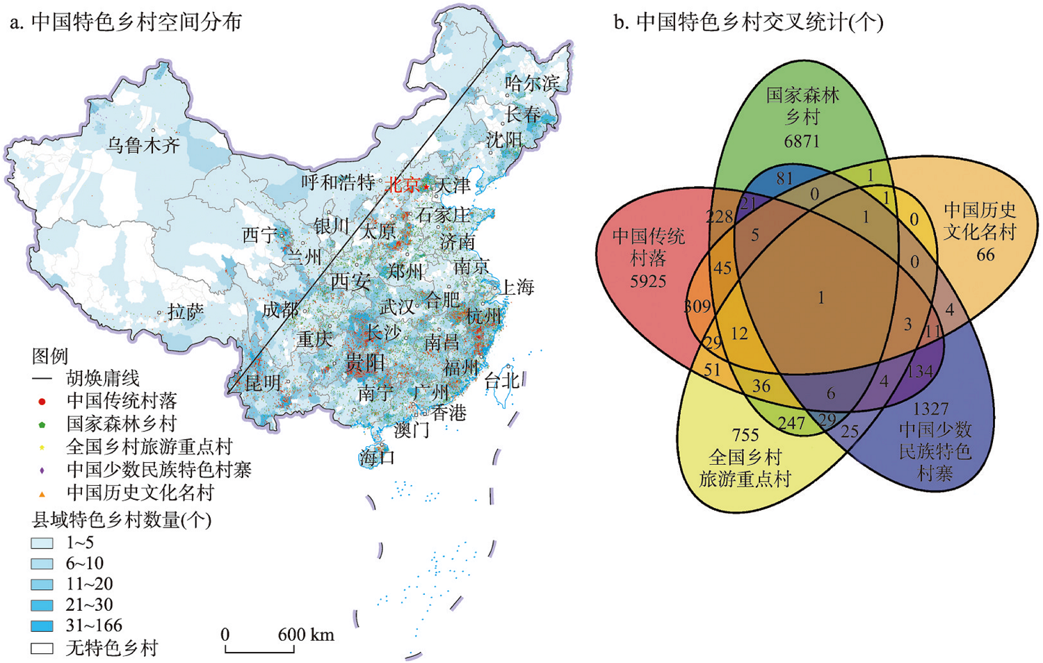
Characteristic villages are important carriers of rural industry revitalization and urban-rural leisure tourism. Although a large amount of characteristic rural resources and their tourism potential have been constantly exploited, the spatial synergistic relationship of different types of characteristic villages remains unclear. This paper analyzes the differentiation pattern, spatial linkage, and function complementary features of national characteristic villages, which include 6819 traditional villages, 7586 forest villages, 1199 key rural tourism villages, 1652 ethnic minority villages, and 487 famous villages with Chinese history and culture. The tourism development potential of characteristic villages is evaluated based on the identification of agglomeration areas of characteristic villages. The collaborative optimization zoning of rural tourism space is proposed based on the location matching degree analysis between characteristic villages and tourism facilities. The results show that the characteristic villages in China are densely distributed in the east and sparsely in the west, and the agglomeration regions are characterized by coastal areas (near the East China Sea), and riverside areas (along the Yangtze and Yellow river). The formation and development of characteristic villages are the results of the interaction of multiple factors, among which, the urbanization rate of county, annual precipitation, population density, and tourism industry scale index have significant effects. The high potential areas for tourism development of Chinese characteristic villages have formed a rhombic distribution pattern, which takes the central cities of the Yangtze River Delta urban agglomeration, Beijing-Tianjin-Hebei urban agglomeration, Guangdong-Hong Kong-Macao Greater Bay Area, and Chengdu-Chongqing urban agglomeration as strategic fulcrums. This paper divides the whole country into priority development area, characteristic mining area, resource integration area, collaborative improvement area, and optimization guidance area, which points out the direction of spatial pattern optimization and coordinated development of characteristic rural tourism.
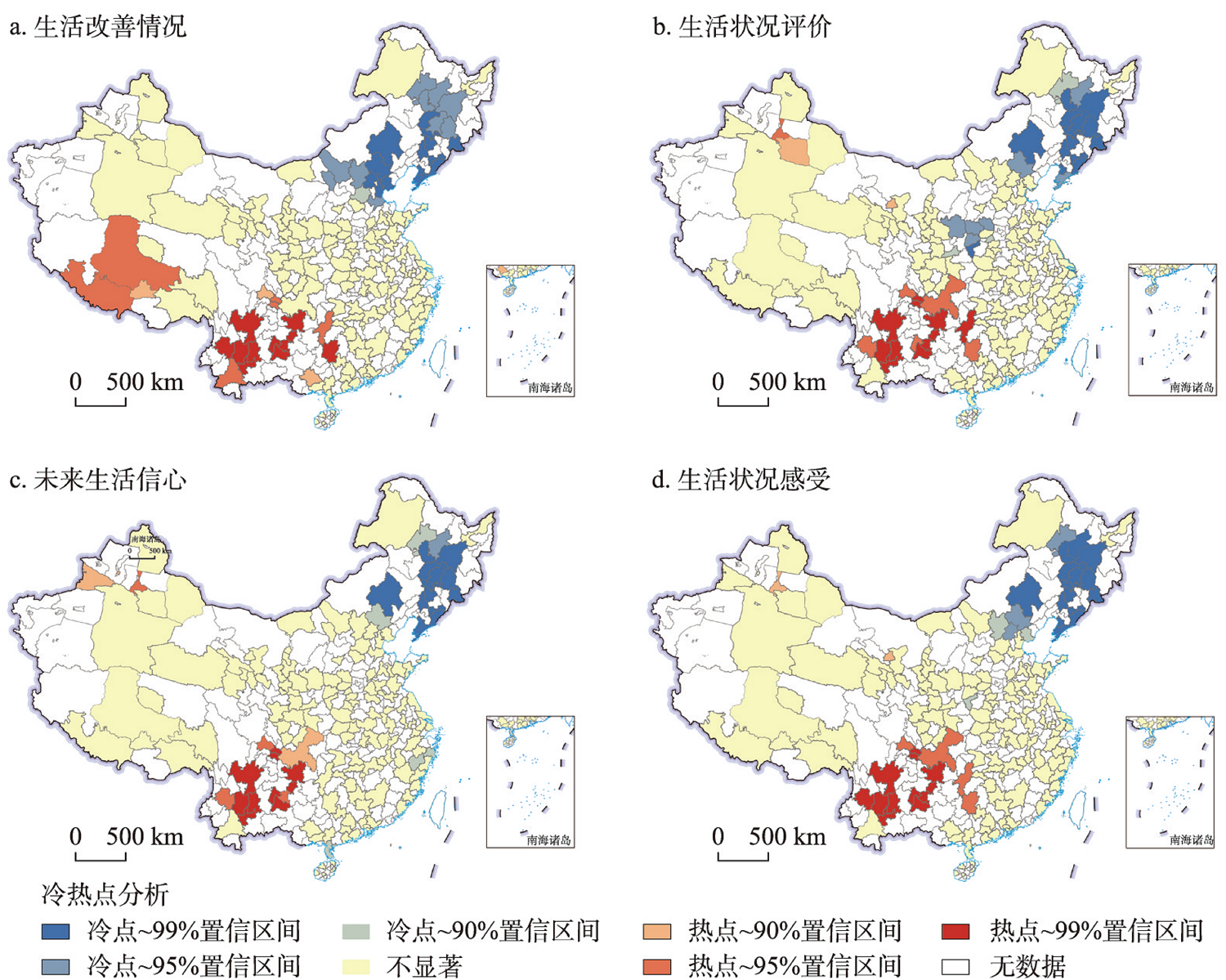
Governing the country is a matter of routine and people-oriented strategy, and improving the people's well-being is "the greatest thing in the country". At present, China is facing the challenge that the national well-being declines with the economic development. This study is based on the national large-scale regional space and adopts the survey data collected in 2020 by the "China People's Livelihood Survey" research group of the Development Research Center of the State Council. The data cover 31 provincial-level regions (hereafter provinces) across the country, including 164 cities at prefecture-level and above, and the number of valid samples is 26370. The research adopts the methods such as the trend surface analysis and spatial analysis of hotspots and coldspots to construct the spatial differentiation and agglomeration pattern of urban residents' perceptions of living conditions in the 31 provinces; the multi-level regression model is used to explore the multi-dimensional influencing factors of perceptions of living conditions at the individual and city levels. The findings are as follows: (1) The differentiation of the living improvement, living condition evaluation, future life confidence and perceptions of living conditions of urban residents in China shows a pattern of high in the west and low in the east, and high in the south and low in the north. (2) The living conditions of urban residents show the characteristics of "continuous agglomeration", and the evaluation of living conditions shows the characteristics of "coexistence of massive agglomeration and scattered distribution", and shows the characteristics of high in the south and west and low in the north and east together with the future life confidence and overall perceptions of living conditions. (3) On average, the highest and lowest values of life improvement, urban residents' living condition evaluation, future life confidence and perceptions of living conditions are also located in the west and east respectively. (4) The influencing factors at the individual level are reflected in gender, age, education level, employment status, household registration status and satisfaction evaluation of urban public services. Among them, satisfaction evaluation of urban public services is reflected in government services, social security status, fair law enforcement status, food safety status, housing status, education status, medical services, transportation status, environmental status, etc. (5) The city size has a significant impact on the perceptions of living conditions of urban residents. Compared with large cities, the perceptions of living conditions of residents in small and medium-sized cities is higher, while that of residents in megacities is lower. In addition, the positive impact of satisfaction evaluation of public services in megacities on the perceptions of living conditions of urban residents has been weakened. Specifically, it mainly weakens the positive correlation strength of medical status evaluation and traffic status evaluation on the well-being effect. The research provides a practical and theoretical reference for the research, judgment and governance direction of China's national perceptions of living conditions.
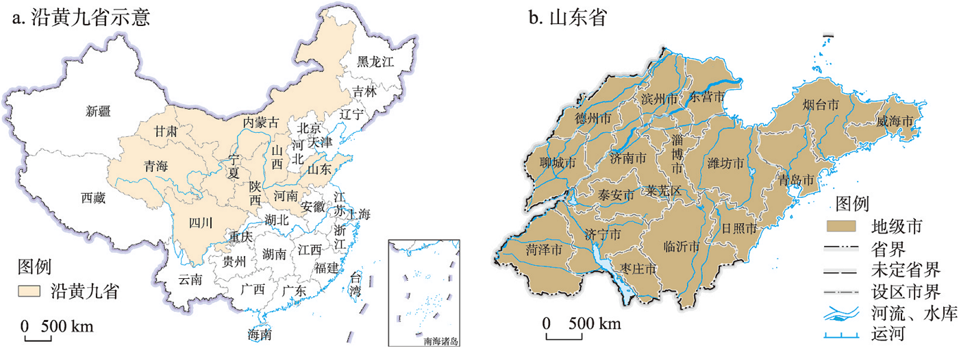
Exploring the co-evolution characteristics of tourism economy and urban ecological resilience can provide theoretical support and quantitative basis for the ecological protection and high-quality development of the Yellow River Basin. From the perspective of evolutionary resilience, this paper constructs an index system of urban ecological resilience based upon "resistance, response and innovation". The theoretical framework of the co-evolution of tourism economy and urban ecological resilience is analyzed with the synergetics. Taking Shandong province as an example, this paper uses the Haken model, kernel density estimation and spatialtemporal weighted regression to analyse the spatiotemporal distribution characteristics and influencing factors of co-evolution of tourism economy and urban ecological resilience. The results show that: (1) From the time dimension, the tourism economy shows a trend of continuous rise at first and then a temporary decline, and the urban ecological resilience shows a trend of stable growth. In terms of spatial distribution, the tourism economy and urban ecological resilience show a spatial pattern of "high-high and low-low concentrations" and "dual core leading", respectively. (2) Tourism economy is a sequence parameter of co-evolution, which dominates the development and evolution of the entire system in this stage, and mainly shows the effect of positive feedback. The co-evolution of tourism economy and urban ecological resilience presents an inverted "V" trend, and forms a spatial pattern of Jiaodong Economic Circle > Lunan Economic Circle > Jinan Economic Circle. (3) There are obvious regional differences in the influencing factors of the co-evolution, and the level of economic development, foreign investment, environmental regulation, financial development, and innovation capability have obvious positive effects. The industrial structure and human capital have barely negative effects. The government intervention shows significantly positive effect in the Jiaodong Economic Circle, but not significantly negative effect in the Lunan Economic Circle and the Jinan Economic Circle.
From the theory of the social construction of nature, this paper constructs a research framework of tourism space production of the river basin based on the logic of "discourse-practice-feedback" from the dimensions of the natural discourse of power subjects, the socialization of nature, and the feedback and response of the man-land relationship, and analyzes the process and evolution logic of tourism space production of Xin'an River Basin. The study found that Xin'an River Basin has experienced four different stages of evolution: (1) In the process of the space production dominated by traditional agriculture and Huizhou merchants' capital, the traditional social structure responded to the natural environment of the river basin, formed a man-land relationship pattern based on agricultural civilization, and injected adaptation mechanisms such as Huizhou merchants' capital with the interaction of man-land contradictions. During this period, the value of natural resources became the logical starting point for the recognition and identification of future tourism resources. (2) In the process of the space production dominated by traditional agriculture and modern water conservancy, people changed the physical space of the river basin, promoted the formation of new landscapes, and provided the ecological, landscape and characteristic industrial basis for future tourism development and ecological civilization construction. While giving it more value, it also triggered new man-land conflicts. (3) In the process of the space production dominated by industry and tourism, tourism has become one of the important goals of river basin's economic and social leading forces and natural construction. Traditional agricultural space has gradually been shaped into modern tourism and industrial production space. At the same time, local power has separated the space representation of the river basin, making the contradiction between protection and development increasingly acute. (4) In the process of the space production dominated by ecological civilization and tourism, tourism has become a driving force for the natural construction of the river basin, reconstructed the distribution pattern of space value, and scientifically guided the natural discourse of the river basin as a new industrial path and new development mode to redraw the spatial blueprint, contributing to new spatial practice. Finally, the paper proposes that we should establish the overall geographical view of the river basin, re-examine the evolution logic of the regional system of man-land relationship based on the river basin from the systematic thinking of the combination of nature and social culture.
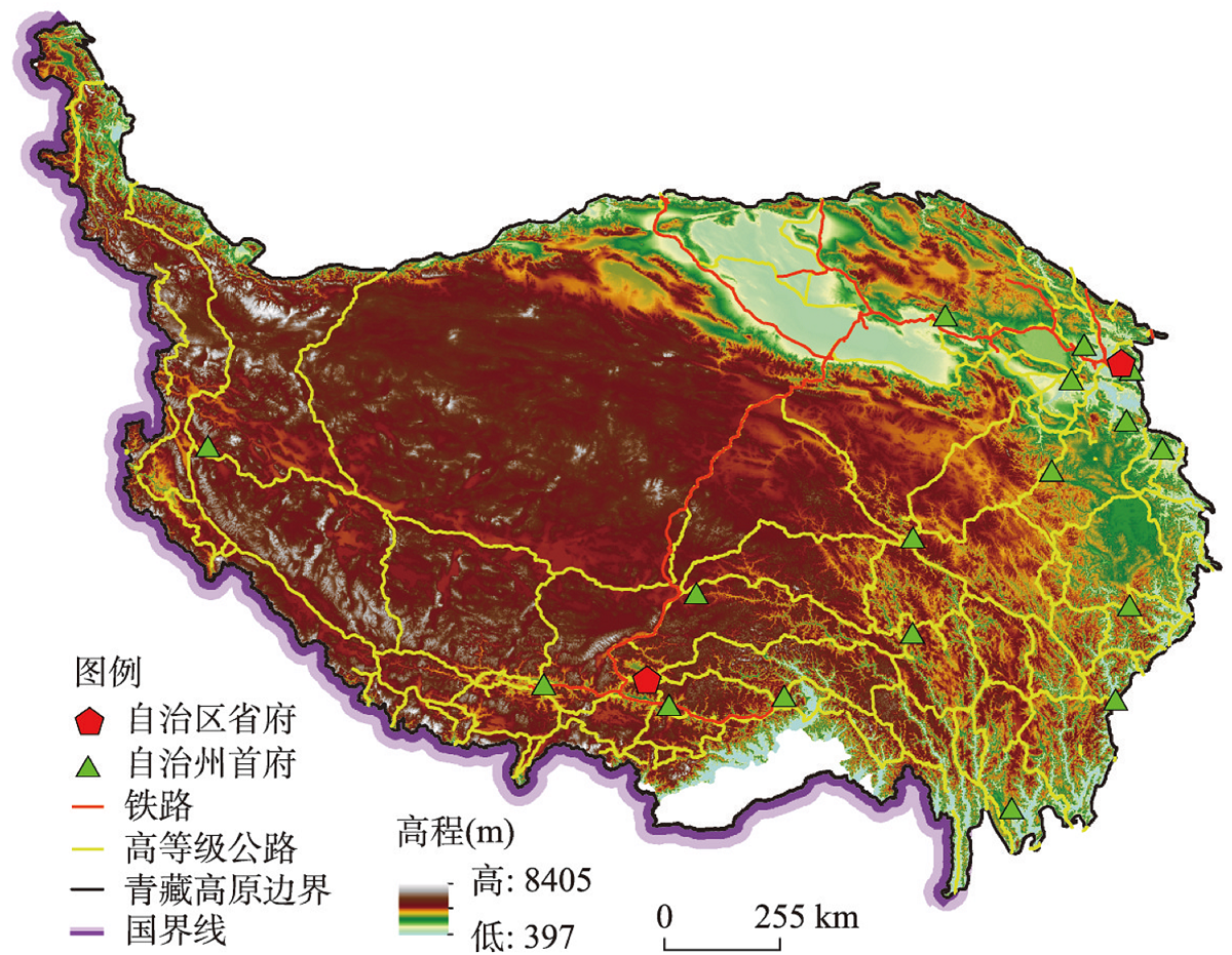
Exploring identification and evaluation methods of tourism corridors is crucial for enhancing tourism destination research and promoting sustainable regional tourism development. Drawing on the relevant theories and identification methods of ecological corridors in landscape ecology, we consider the convergence of tourism flow patterns and the nature of biological migration, constructing an identification path of "determining tourist source - 'tourism transportation' network simulation - 'transportation tourism' corridor identification." The Qinghai-Tibet Plateau is used as a typical case study to comprehensively identify and evaluate tourism corridors within this region. The results indicate that: (1) The "tourism transportation" network in the study region is composed of 23 source areas and 53 sections, exhibiting a loop network feature and a pattern of "dense in the east, but sparse in the west". (2) By comparing the differences in the degree of facility and service guarantee for "tourism transportation" network sections, the overall performance is ranked as "medical services" > "shopping" > "catering" = "accommodation" > "transportation" > "entertainment" > "tourism", radiating and attenuating from the two core cities of Xining and Lhasa. (3) On this basis, six mature "transportation tourism" corridors were identified: Qinghai-Tibet Line, North Sichuan-Tibet Line, South Sichuan-Tibet Line, Yunnan-Tibet Line, Border Line, North Gansu-West Sichuan Line. Two potential "transportation tourism" corridors were also identified: Xinjiang-Tibet North Line and Tang-Tibet Ancient Road Line. This study constructs a set of identification and evaluation method paths for regional tourism destinations to transition from a single-functional "tourism transportation" network to a multi-functional "transportation tourism" corridor. This case study also verifies the feasibility and universality of this method.