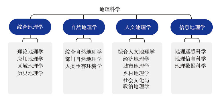
The modern international and domestic science advancements have brought forward new opportunities as well as higher requirements to the development of geographic science in China. In planning the disciplinary structure of geographic science in the "Development Strategy of Discipline and Frontier Research in China (2021-2035)", we propose a modified disciplinary structure for the geographic science in the new era. The geographic science in China can be categorized into four secondary disciplines, i.e., integrated geography, physical geography, human geography, and information geography, considering the current situation and development outlook of geographic science. The tertiary disciplines under each secondary discipline are nearly fully developed, and a few quaternary disciplines under tertiary disciplines have already been widely accepted and used. We hope this new disciplinary structure can play a breakthrough role for improving the branches of geographic science, promoting the development of emerging disciplines under the framework of geographic science, and better serving the international and domestic development needs in the new era.
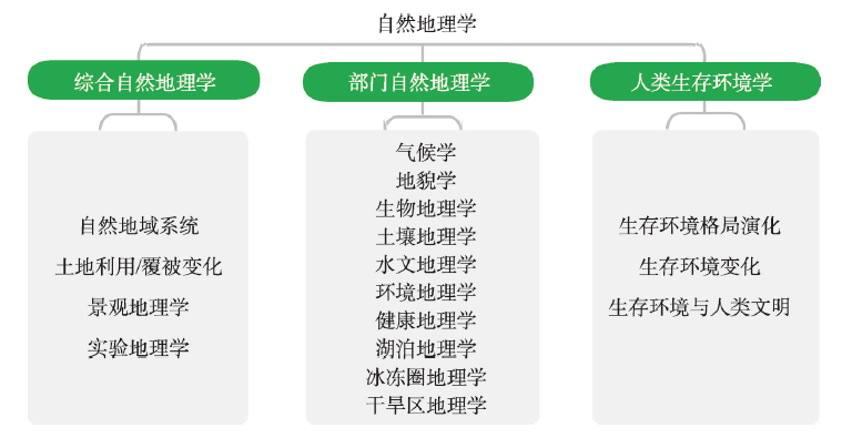
Physical geography, one of the branches of geographic science, is the basic discipline of geographic science. And it is the scientific foundation of ecology, environmental science and other related disciplines. Physical geography focuses on spatial characteristics, evolution and regional differentiation of the earth's surface. In the new period of rapid development of social economy, and science and technology, physical geography is more closely and widely connected with human geography and, information geography. Based on "The Development Strategy of Discipline and the Frontier Research (2021-2035)" and geography subject planning, this paper analyzed the forming process of the physical geography, expressed sub-discipline structure of comprehensive physical geography, sectoral physical geography, human survival environment, and proposed the development strategy of physical geography and its branch disciplines, key priority of development goals and directions.
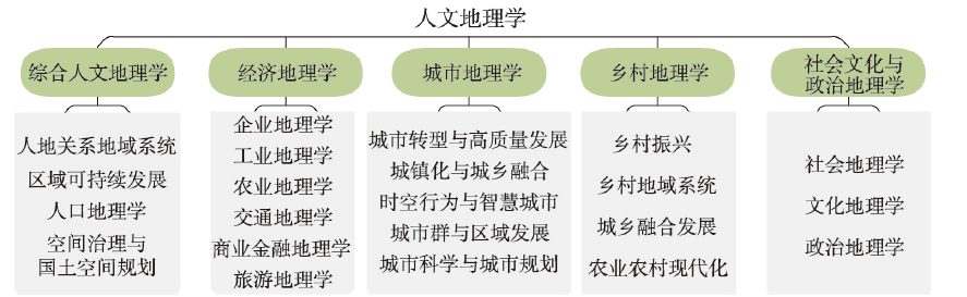
Human geography is a discipline which studies the formation and evolution of the geographical distribution pattern of human activities. The main research objects of human geography focus on human activities and human-earth relationship. The scientific questions to be answered by human geography cover both natural science and social science, and thus it has distinctive interdisciplinary features. In China, the economic and social processes of human activities are playing an important role in explaining the law in human geography discipline as human society development is approaching or has entered the post-industrialization stage. The logics and methods of social science have become important tools through which the changes in processes and patterns of human geography can be reasonably discussed and properly understood. Research methodology of human geography shows integration characteristics between natural sciences and social sciences. The outcomes of human geography research reveal scientific laws in geographical distribution pattern and evolution of human activities. It becomes one of primary disciplines for both the national and local governments to manage and optimize the pattern of spatial development and protection. It has wide applications in spatial planning, regional strategy and policy making, and the modernization of spatial governance. The unique feature in integrating academic research and policy-making applications provides human geography discipline in China a superiority of leading the world in the discipline. Besides comprehensive human geography, human geography in China has five subdisciplines, namely, economic geography, urban geography, rural geography, social and cultural geography and political geography. Each subdiscipline has priority and key research fields, and coordinates with the rest of subdisciplines.
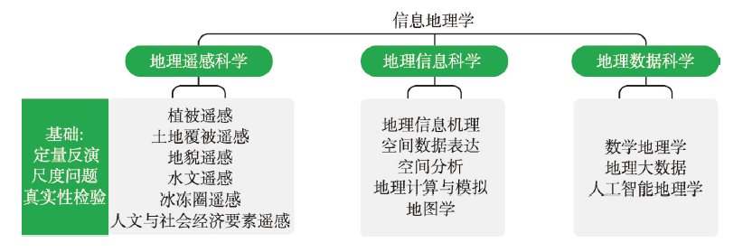
The arrival of the information era has exceptionally advanced the development of geographic science. The research scope of the discipline has expanded from the space of traditional physical and human geography to the space of information geography. Meanwhile, the discipline gradually formed three subdisciplines, i.e., geographic remote sensing science, geographic information science, and geographic data science. In the context of preparing the disciplinary structure of geographic science of the "Development Strategy of Discipline and Frontier Research in China (2021-2035)", this paper summarized the history, definition, and disciplinary structure of information geography. Additionally, it highlighted the strategic layout of the discipline, as well as the goals and key directions of its priority development fields. We expect this paper to provide insight into the new discipline that could help promote the developments and applications of remote sensing and geographic information within the framework of geographic science, strengthening the synthesis of geographic research and promoting the integrated development of geographic science.
Resident food consumption is affected by factors such as the natural geographic environment and urbanization. At the same time, food consumption will affect regional food security and the development of agriculture and animal husbandry through market mechanisms. Taking the Yarlung Zangbo River and its two tributaries of Tibet (also known as Three-Rivers Region) as a typical case, this paper obtained the food consumption data of 262 rural residents by field surveys based on stratified sampling, and then analyzed the food consumption structure of the rural residents and its influencing factors in the Tibetan Plateau. The results indicated that: (1) The consumption of plant foods of the residents in the sample is 3.19 times that of animal foods, with vegetable and grain as the main plant food and meat and milk as the main animal food. And highland barley and highland barley liquor are important in the diet of Tibetans. (2) The scale and structure of food consumption of residents are closely related to the index of food self-sufficiency, and the characteristics of self-sufficient food consumption are significant. (3) Among different regions, family sizes, scales of migrant worker, income levels and family ages, the food consumption structure of residents varies, and the differences in the consumption of flour and fruits between different families are the most significant. (4) Regional differences, family sizes and migrant worker scales are the main factors that affect the comprehensive difference of food consumption in the sample rural areas. The research results of the paper can provide scientific basis and guidance suggestions for the improvement of food consumption structure, promotion of dietary nutrition and transformation and development of agriculture and animal husbandry in the Tibetan Plateau.
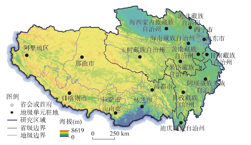
The Qinghai-Tibet Plateau (QTP) has unique features of high-cold environments and natural conditions, which have limited the natural distribution and orderly development of its population, and then has formed a large and widely distributed Unpopulated Areas (UPAs). However, the information of the area size, distribution extent, geographical characteristics and regional differences of the UPAs in this plateau is still not available. Therefore, it is significant to define accurately the spatial extent and geographical distribution of the UPAs for the assessment of resources and environmental carrying capacity and constructing the national parks and ecological security barrier in this plateau. Based on the distribution information of residential areas in the QTP, from the characteristics of topography, climate, ecology (oxygen content), land use and other elements, the study aims to examine the relationship of natural-ecological-land use system. Therefore, we developed a comprehensive evaluation model of the "UPAs" through the spatial overlay of multiple elements. The key thresholds determined in the aspects of physical and ecological (oxygen content) limits and land use characteristics, were then used to define the geographical distribution and to examine spatial characteristics of the UPAs in the QTP, China. The results showed that: (1) With the cumulative proportion of residential distribution < 0.1%, we defined the topographic thresholds of the UPAs including the elevation > 5665 m, relative height difference > 2402 m, the relief degree of land surface (RDLS) > 8.59, and the climatic thresholds including the relative humidity > 76.2% and the temperature humidity index (THI) < 33 or > 71. (2) According to the distribution of residential areas and oxygen content tolerance of the human being, the oxygen content thresholds of UPAs were determined as air pressure < 500 hPa, oxygen content < 40%. (3) The resultant UPAs on the QTP covers an area of 1912 km 2, including 699 km2 in Xinjiang, 413 km2 in Sichuan, 331 km2 in Tibet, 291 km2 in Qinghai, and 178 km2 in Gansu. The UPAs are scattered sporadically, mostly distributed in Gonggashan Mountain region in Sichuan, the extremely high mountain areas such as Mount Everest in the Himalayas, and the northern Hoh Xil and Lop Nur region, as well as a small part of the UPAs in the Qaidam Basin of Qinghai.
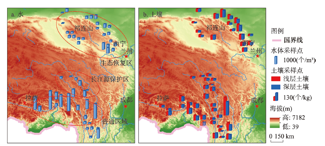
Microplastics as emerging pollutants have attracted increasing attention. This study explored the microplastics in water and soil environments of Qinghai-Tibet Plateau and discussed their potential sources. We collected 53 water samples and 52 soil samples from May to July in 2019 in two major regions, i.e. the southern Qinghai-Tibet Plateau and the Qilian Mountains region (national ecological restoration area in the plateau). The microplastic abundance of water in the southern Qinghai-Tibet Plateau was significantly higher than that in the Qilian Mountains, while no significant difference existed in soil samples between two regions (p > 0.05). The concentration ranges of microplastics were 0-1916.66 items/m3 and 0-260 items/kg in water and soil, with the average values being (438.21±454.94) items/m3 and (48.35±36.25) items/kg, respectively. Microplastics in water were mostly transparent fiber with the main polymer being polypropylene, while the most common form in soil was transparent film with the dominant polymer being polyethylene. Source analysis showed that the major sources of microplastics in water might be laundry wastewater and waste from tourism, while agricultural plastic mulch would be potentially responsible for microplastics in soil. The results proved the existence of microplastics in most of soil and water environments in the Qinghai-Tibet Plateau, and provided important supports for future studies on microplastics migration and transformation mechanism at high altitudes.
The floating population has become an important driving force of population growth in the Qinghai-Tibet Plateau in recent years, and thus the settlement intention of the floating population is of vital importance to the sustainable urbanization of the Qinghai-Tibet Plateau. Based on the data of China's floating population dynamic monitoring survey in 2017, this paper measured the settlement intention of the floating population in the study area, and according to their migration source of Qinghai-Tibet Plateau area, and distinguished the short- and long-distance floating population, and then compared their settlement intentions. Following this, we built a multi-level logistic regression model to analyze the underlying driving forces of the settlement intentions of the floating population as well as the possible differences between the short- and long-distance floating population. The main findings are as follows: (1) The overall settlement intention of the floating population in the plateau area was not high, and only about 32% of the floating population intend to stay in the urban areas for a long time; except for Lhasa, Xining and Haixi, that proportion is only about 10% of the prefecture units. (2) The settlement intention of the short-distance floating population was significantly higher than that of the long-distance floating population, but the percentages of the short-distance floating population with long-term settlement intention in most prefecture units were still less than 20%. (3) Education level, income level, urban medical insurance, social integration, economic development level and natural conditions of the inflow destinations have significant influence on the settlement intention of the floating population. (4) The difference of settlement intention between short- and long-distance floating population was closely related to the migration motivation and the social integration. Based on the above findings, this paper suggests that it is necessary to take targeted measures to improve the settlement intention of the short- and long-distance floating population in terms of the influencing factors, and also explore the suitable urbanization pattern for the Qinghai-Tibet Plateau area, such as promoting the local urbanization.
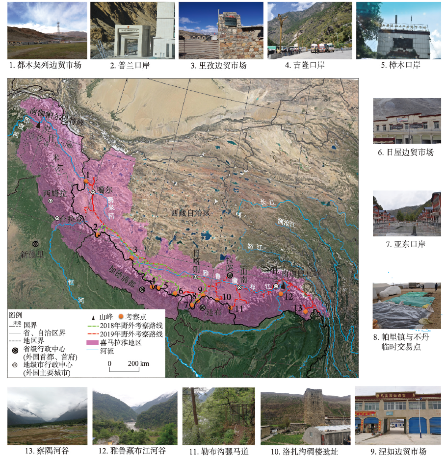
Traditional trade routes that penetrate the natural barrier of the Himalayas are critical for connecting major Chinese and South Asian markets. Research on these trade routes can contribute significantly to facilitating the construction of the South Asia Channel and enhancing trans-Himalayan connectivity. Combining historical literature, field surveys, and Geographic Information System (GIS) techniques, this study examined the spatial distribution characteristics and dynamic mechanisms driving the formation, development, decline, and restoration of the routes, focusing on transverse valleys of the Himalayan arc. The key findings were as follows. First, there are 21 traditional trade routes traversing the Himalayan region: 6 Sino-Nepalese routes, 4 Sino-Bhutanese routes, and 11 Sino-Indian routes. The routes are arranged in a "one horizontal and multiple vertical" spatial pattern. Second, the evolution of the traditional trade routes has entailed five distinct phases: an incipient period (pre-7th century), formation (7th century-842 AD), development (842-1959), decline (1959-1962) and recovery (1962-present). Third, the incipient and formative developmental phases were prompted by the spread of Buddhism and the exchange of goods. The stability of local governments in Tibet and in the Central China Plains and favorable border trade policies along with Britain's colonial expansion and commercial interests stimulated further development of traditional trade routes. However, India's strategic miscalculation and "Forward Policy" instigated the decline phase, while China's strategic needs are currently the key driver of the restoration and construction phase. Finally, a lack of strategic mutual trust and existing border issues are the main obstacles impeding the restorative and construction phases. Future efforts to support the construction of the South Asia Channel and the stability and development of border regions should focus on strengthening multi-perspectival investigations and research on traditional trade routes, formulating strategies for corridor construction and control, and emphasizing the corridor's commerce, tourism, and cultural exchange functions.
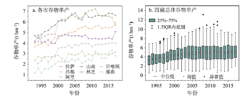
Climate change, which can lead to environmental problems, has become a global concern, especially in the Tibetan Plateau. However, there are few studies on quantitative assessment of climate change on agricultural crops in the Tibetan Plateau. We used meteorological data and yearbook statistical data to assess the impact of climate change on cereal yields of Tibet. Three types of statistical models were selected, including fixed effect model, first-difference model and linear de-trend model. We analyzed the impacts of climate change (minimum temperature, precipitation, growing degree days, and solar radiation) on cereal yields at the county, city, and autonomous region scales in Tibet from 1993 to 2017. The results showed that the sensitivity of cereal production to temperature (minimum temperature and growing degree days) was greater than that to precipitation and solar radiation. The joint impacts of climate variables were positive, but the sensitivity and significance of different regions were different. Except for the negative impact of growing degree days on Lhasa, the impacts of minimum temperature, precipitation and solar radiation were positive on all cities. The impacts of climate trends on the cereal yields in Tibet Autonomous Region were positive and the results of different models were concentrated in the range of 1.5% to 4.8%. Among the three types of models, the fixed effect model performed best in robustness, and the linear de-trend model was better than the first-difference model. After we add the interaction between different climate variables, the robustness of the first-difference model decreased. Our study could help implement more spatially targeted agricultural adaptation measures to cope with the impact of climate change on the agricultural ecosystem of the Tibetan Plateau.
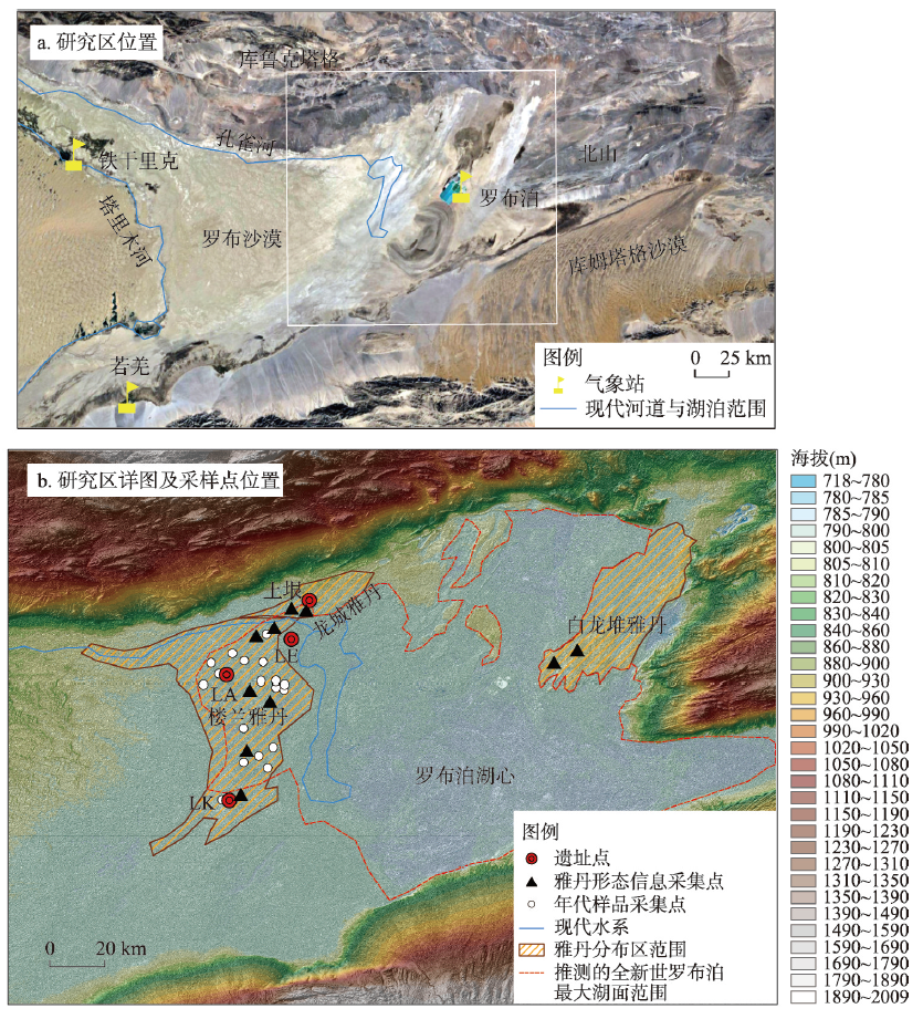
Yardang is a typical, aeolian erosion landform widely distributed on Earth and discovered on other planets (Venus and Mars) too. Because of its various forms and volatility, yardang's morphological characteristics have attracted attention for generations. Lop Nur is located in the eastern part of the Tarim Basin in Xinjiang, China. Although there are many yardangs with various types in the area of Lop Nur, there is a lack of study about this impressive landform there. On the basis of field investigation, the authors found that UAV drones can efficiently and effectively collect yardang morphology data. Based on collected yardang morphology data (including field survey and DEM from UAV), using the terrain digital extraction method, after measuring the morphological parameter data of yardang, this article attempts to clarify the morphological characteristics of yardangs in the Lop Nur area, and to discuss its formation processes. The main conclusions are as follows: (1) The lengths of yardangs in the Lop Nur area are often < 20 m, although a few of them are even > 160 m. The widths of yardangs in our study area are mainly < 8 m, with a height of mostly < 2 m. It shows that the sizes of yardangs in the study area are generally small, although some large ones occur too. The ratio of length vs. width (R) of yardangs ranges from 2:1 to 4:1, and even > 10:1. The orientations of the yardangs in our study area are mainly toward 22.5°-67.5°, consistent with the predominant wind directions. Our observations suggest that the morphology of yardangs in the study area initiated from a dome-shaped form and then changed to drop-shaped, and finally to linear forms. The number of yardangs occurring nearby is often 3-4, and the distance between them is often < 20 m but occasionally 40-80 m. (2) The most likely evolution processes of yardangs in the Lop Nur area can be summarized into four stages: embryonic, juvenile, mature and decay periods. However, due to the influence of various controlling factors such as stratum sediment characteristics, wind erosion, and flowing water, yardang's morphology in the Lop Nur area become quite complex. (3) The developments of yardangs in the Lop Nur area have multiple periods. Since the Quaternary, there have been four main development periods in late Pleistocene (ca. 90 ka B.P.), early Holocene (8-9 ka B.P.), late Holocene (after 1.6 ka B.P.) and Little Ice Age (around 0.5 ka B.P.). According to morphological characteristics and environmental evolution, we infer that yardangs in Longcheng and Bailongdui were formed in the late Pleistocene, the northern Loulan grand yardangs formed in the Early Holocene, yardangs in central and northern Loulan formed in the late Pleistocene and the small yardangs in Loulan area formed probably during the Little Ice Age. Based on the chronology and yardangs' height, the average wind erosion rate near the Loulan site after 0.5 ka B.P. was calculated to be 6.2 mm a-1. Accurately describing the morphological characteristics of yardangs in the Lop Nur area and understanding its evolution procession is of great significance for analyzing the morphological development of yardangs and the regional wind erosion process.
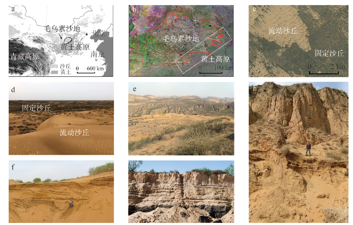
Sand seas and semi-arid dune fields, an important component of the earth environmental system, is sensitive to global climate change. Meanwhile, environmental changes in sand seas and dune fields influence regional sustainability, and can also affect regional climate and global environment through feedbacks of different scales. The Mu Us Sandy Land, located in the north-central part of China, is one of the typical semi-arid dune fields in the middle latitude. Its aeolian environmental change during the past is comparable and synchronous with some other sand seas and dune fields around the world. The study of aeolian environmental change in the Mu Us Sandy Land has a long history in China. This paper reviews and summarizes the theory and new findings in the study of processes and mechanisms of aeolian environmental change in the Mu Us Sandy Land. Important progresses have been made in recent decades focusing on the late Cenozoic evolution of the study area, its late Quaternary expansion and polycyclic changes, and dune field stabilization during the middle Holocene and dune reactivation since the late Holocene. Key sedimentary evidence has been found to support these new findings, and new theories about dune field evolution at the tectonic and orbital scales in response to global temperature change and nonlinear response of dune systems at millennial and centennial scales have been proposed. In the future, by collecting more crucial sedimentary evidence, the application of state-of-art technique, fine-scale and process-informed paleoenvironmental reconstruction, and numerical modeling and projection studies, our understanding can be significantly improved about the dynamical mechanisms of aeolian environmental change, the coupling of human-environment complex system in the drylands, and the processes and feedbacks in the Earth surface environmental system. This will also have great significance for the development in the field of physical geography, integration of interdisciplinary studies, and theory exploration of the Earth System Science.
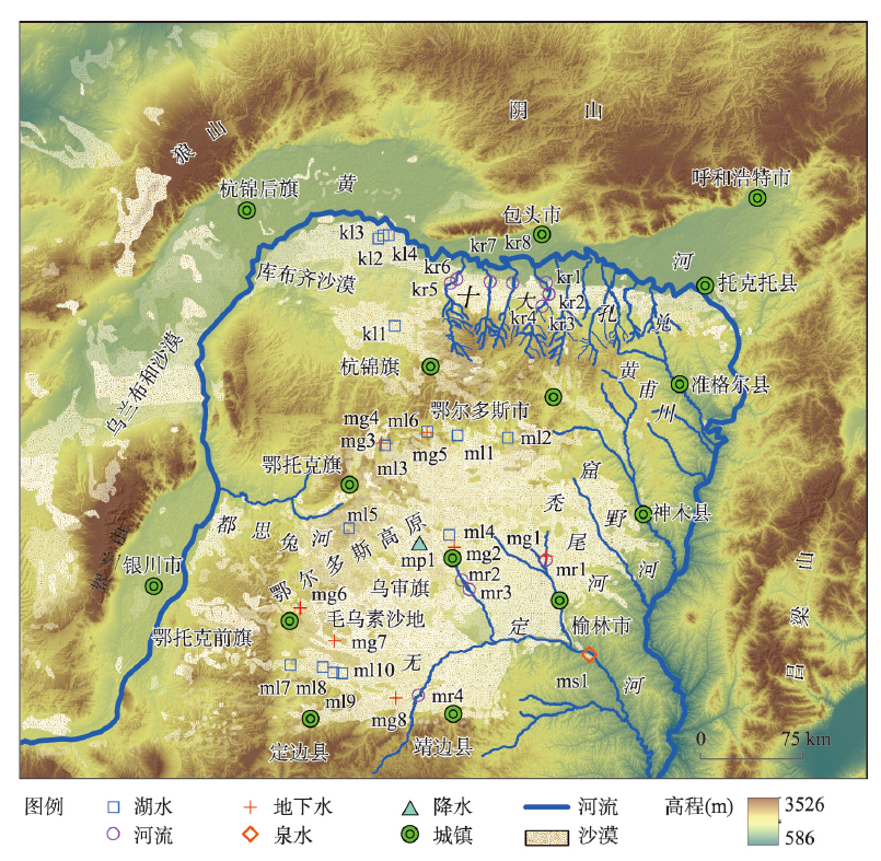
The analysis of hydrochemical compositions of natural waters and their influencing factors is helpful to understand the regional hydrogeological environment and hydrogeochemical development history. The Ordos Deserts, consisting mainly of the Mu Us Sandy Land and the Hobq Sand Sea, are located in the south of Hetao Plain, north to the Great Wall, surrounded by the Yellow River in the west, north and east, and adjacent to the Loess Plateau in the south. The Ordos Deserts make up the Ordos Plateau, with the same tectonic background, similar amount of precipitation and evaporation rates. There are a large number of lakes and rivers in these deserts. In this paper, based on the hydrochemical data of natural waters in the Ordos Deserts, the chemical compositions of natural waters and their influencing factors are analyzed, using various hydrochemical analysis methods. Results show that although Mu Us Sandy Land and Hobq Sand Sea have different landscapes, their natural waters of the same type have similar hydrochemical features, which should be related to their similar rates of evaporation. Deep groundwater in the Ordos Deserts is mainly Ca2+-HCO3- type and its chemical composition is mainly influenced by rock weathering. Due to strong evaporation, the hydrochemical nature of lakes in these regions is characterized with Na+-Cl- contents. As for shallow groundwater and river waters, their hydrochemical features and influencing factors show transitional characteristics between deep groundwater and lake water. The ion ratios show that the weathering of evaporites, carbonate and silicate rocks affects the hydrochemical composition of deep groundwater, shallow groundwater and river water to a varying degree. Although the groundwater and river water in the Ordos Deserts are suitable for irrigation, an excessive use of them will cause salinization, which should be given attention timely.
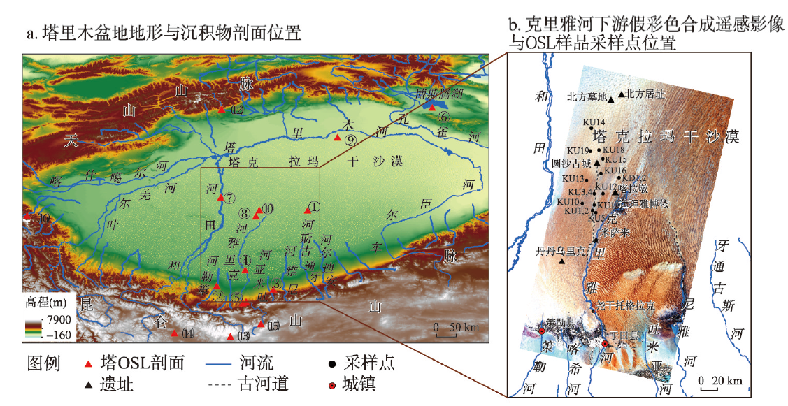
Climate change impacts on the relationship between fluvial processes and dunes landform evolution have been a research topic. However, the chronology data used to examine such relationship are deficient. The Keriya River has a glacial origin in the Kunlun Mountains at the south margin of the Tarim Basin. The river flows into the Taklamakan Desert, the second largest shifting dunes desert in the world. The dry channels and shifting dunes in the area provide an ideal opportunity to understand fluvial and eolian landform evolution processes and their relationship with climate change. We investigated this area from 2008-2011, and obtained 18 fluvial sediment samples from 16 sections for optically stimulated luminescence (OSL) dating. Results show that the ages are ranged from 3.4-44.1 ka. Most (13) samples were from the Holocene, around 11 ka, 8-9 ka, 5-6.5 ka, 4.6 ka and 3.4-3.7 ka respectively. which were distributed along ancient river channels around Yuansha and Karadun. Two samples close to the Hotan River (38-47 ka) fall in the Marine Isotope Stages 3 (MIS3). Three samples (of one section) were located near ancient channels flowing towards the Yuansha Site aged around 14.5 ka, the Last Glacial Maximum (LGM). The sediment samples and OSL ages of this work suggest that the Keriya River was flooded in the Holocene, the LGM and the MIS3 stage. Fluvial sediment provided source material for dunes and fluvial processes impacted landform evolution at the lower reaches of the Keriya River. Our results suggest that most dunes covered on fluvial sediments at the lower reaches and west of the Keriya River developed since the Holocene. This differs from previous works suggesting that they developed "since the Han and Tang dynasties". The OSL ages of fluvial sediments were consistent with the reported deglaciation (after glacial advance) ages in alpine mountains surrounding the Tarim Basin. This suggests that climate fluctuation might have impacted the occurrence of floods and the formation of dunes in the Taklamakan Desert.
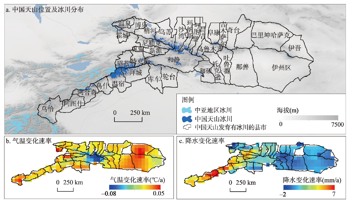
Glacier is a crucial freshwater resource for populations and socio-economies in arid and semiarid regions, and the vulnerability of glacier change is an issue concerning regional ecological services and sustainable socio-economic development. We took Chinese Tianshan Mountains as an example and constructed a basic framework of the vulnerability of glacier change covering factors such as physical geography, population status, socio-economic level, agricultural development and social services based on exposure, sensitivity and adaptability, and constituted a targeted evaluation index system accordingly. We examined the spatial structure and spatial autocorrelation of the vulnerability on glacier change using ArcGIS and GeoDa softwares. We discussed the influence and interaction of natural conditions, socio-economy, population and other factors on glacier change adaptability using the GeoDetector model. Our results suggest that: (1) The vulnerability level decreased from west to east with significant differences. The eastern part of Chinese Tianshan Mountains has the lowest vulnerability, followed by the central part, and the western part has the highest value. (2) There is a significant positive correlation between exposure and sensitivity and a significant negative correlation between exposure and adaptability, indicating that the areas with high exposure and high sensitivity to glacier changes tend to have low adaptive capacity, which leads to higher vulnerability; on the contrary, the vulnerability is low. (3) The spatial heterogeneity of the ability to cope with glacier change in the Tianshan Mountains is the result of the combined effects of natural, social, economic and demographic factors. Among them, factors such as the production value of secondary and tertiary industries, urban population, urban fixed-asset investment and employees at the end of the year play a leading role.
The Qinling-Daba Mountains form the main body of China's north-south transitional zone. However, because there is a controversy about the specific location of the geographical boundary in academic community, it is important to determine and improve the existing classification indices to construct the ecological geographical pattern in China. Soil is the core section of the transitional zone, the spatial distribution and variations in key soil indexes in the Qinling-Daba Mountains are important indicators for identifying the transition effect and regional characteristics of China's north-south transitional zone. This paper analyzes the spatial characteristics of soil organic carbon (SOC) and total nitrogen (TN), and their relationships with major geographical factors by means of spatial analysis and geostatistics, using data from the second national soil survey, as well as terrain, climate and vegetation data. Results show that spatial trends of SOC and TN contents are similar, and that there are three areas with high contents, one secondary area with high content and one area with low content. The high contents are found in the high-altitude regions of the Qinling-Daba Mountains and in the mountainous areas to the west of the Jialing River. Here, SOC and TN contents range from 15.03-71.04 g/kg and 1782.61-7710.00 mg/kg, respectively. The low-content areas spread from west to east across the Weihe Valley, to the southern Wutai and Funiu mountains, and along the north slope of the Qinling Mountains. Here, SOC and TN contents range from 0.64-6.50 g/kg and 110.00-885.96 mg/kg, respectively. The secondary high-content area is mainly located on the both sides of the Hanjiang River, in the Qinling-Daba Mountains where altitudes are less than 1000 m, in the Funiu Mountains at altitudes less than 1000 m and on both sides of Jialing River at altitudes slightly higher than 1000 m. Here, SOC and TN contents are between the above two ranges, with a gradual increase in content forming a "horn-shaped" pattern from west to east. In terms of the spatial characteristics and functions of vegetation, topography and climatic factors, it is found that the SOC/TN range in the secondary high-content area is consistent along the 1000 m contour line, at the upper limit of the warm temperate deciduous broadleaved forest belt (containing evergreen forest) and of the subtropical/warm temperate mixed evergreen-deciduous broadleaved forest belts, as well as along the 0 °C isotherm line in January and the 24 °C isotherm line in July. The temperature changes are stable in January, July, annually and during the four seasons, but the rainfall varies greatly in each season. This region is the main body area of the transtional zone between subtropical zone and warm temperate zone: the northern boundary is roughly distributed along the line of Dujiangyan-Maoxian-Pingwu-Wenxian to the west of the Jialing River and the 1000 m contour line on the southern slope of the Qinling Mountains. The southern boundary lies along the line of Dujiangyan-Beichuan-Qingchuan to the west of the Jialing River and the 1000 m contour line of the northern slope of the Daba Mountains. The results show that the spatial variation of SOC/TN content provides a reference for the demarcation of the subtropical-warm temperate zone. A further understanding of the soil processes and ecological effects in typical regions and typical mountains will help reveal the multi-dimensional transition characteristics and variation mechanism in the region.
In order to investigate the past 150-year history of atmospheric dust deposition and its effect on the Asian monsoon zone and marginal zone, ombrotrophic peats from the Changbai Mountians were used to reconstruct the past history of atmospheric dust deposition based on the grain-size, lithogenic elements and 210Pb and137Cs dating. The dust deposition sequences were compared with those from Motianling peat of Great Hinggan Mountains. The mountain peat ash in northeast China was mainly composed of clay and silt. The medium grain size and the lithogenic elemental fingerprints also preliminarily revealed that the mineral dust in the mountain peat of northeast China were mainly from the soil dust in Mongolian and northern China desert and sand land areas. The atmospheric soil dust deposition flux increased gradually from the 1800s to the 1960s, which was consistent with the increase of human activities such as regional modernization, industrialization and aggressive wars. There was a decreasing trend in the atmospheric soil dust deposition during the past 60 years in northeast China, as shown by the mountain peat records, which is in good agreement with the monitoring data of regional natural dust storms. The background baseline of the long-distance atmospheric soil dust deposition flux in northeast China is calculated as 5.2±2.6 g m-2 a-1. The mean atmospheric soil dust flux was 5-38 g m-2 a-1 in the Changbai Mountain area, and that value was 14-68 g m-2 a-1 in the Great Hinggan Mountain area. The atmospheric dust deposition rates derived from the Changbai Mountain peat were smaller than those derived from the Great Hinggan Mountian peat. This suggested a decreasing atmospheric dust deposition with the increasing distance from the dust source area, and thus the influence extent of atmospheric dust deposition on the western side was higher than that on the eastern side of northeast China.

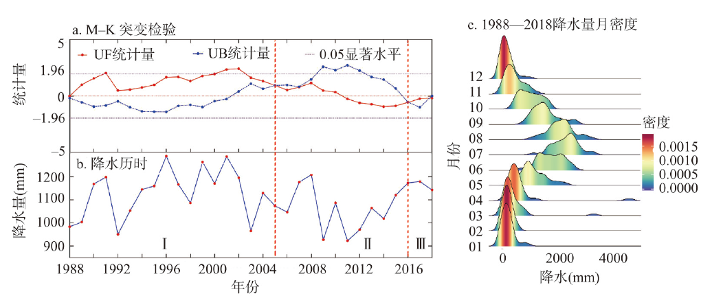
As the effects of climate change become more devastating, the changes of precipitation patterns and food supply are and will be major challenges facing mankind nowadays and in the future. But the interannual relationship between the precipitation patterns and the food yields is still unclear. Studying changes in food yields and precipitation in those areas where the southwest and southeast monsoons interact is significant to revealing the dynamic correlation of food and precipitation, achieving regional food security, ensuring the stability of the southwestern frontier, implementing regional ethnic policies, and building a harmonious well-off society. The paper takes Yunnan Province in Southwest China as an example to describe the pattern of precipitation changes from 1988 to 2018 and discusses its impact on food production. The results suggested that: (1) The precipitation patterns of Yunnan are classified into three periods: Ⅰ abundance period (1988-2004), Ⅱ shortage period (2005-2015), and Ⅲ recovery period (2016-2018). (2) Areas with significant changes account for 15.07% of the whole province in periods I-Ⅱ to 13.87% in periods II-Ⅲ and to 16.53% in periods I-Ⅲ. (3) There is a significant positive relationship between precipitation and food supply (p < 0.01) across the province. The correlation index between crops yields and precipitation of the three periods is higher than that between precipitation and meat-and-dairy products. (4) In three precipitation value (d) zones, food yields had different responses to changes in precipitation. When d ≥ 1500 mm, the precipitation plummets while the food yield remains stable. When 1500 > d > 700 mm, the two values will decrease simultaneously. When d < 700 mm, a small decrease in precipitation will cause a large decrease in food yields. All in all, the precipitation pattern in Yunnan has undergone significant changes in the past 30 years, which has an essential impact on the food yields in different regions. Therefore, sorting out the grain-precipitation spatial region of the province can help us combat the increasing precipitation pattern changes.
The tidal creek is the main channel for the interaction of the land-sea ecosystem and has a high degree of spatiotemporal dynamics. Taking the old and new river courses in the Yellow River Delta as the boundary, the North Bank of the Yellow River (Area I), the East of the South Bank (Area II), and the West of the South Bank (Area III) are divided into comparative study areas. Remote-sensing images of five key time nodes from 1998 to 2018 are selected as the data source. Using the GIS spatial analysis function, the typical morphological characteristics of the tidal creek development degree are quantitatively characterized. The influence of factors such as the Yellow River diversion, wetland restoration project, and alien species invasion on the development process of tidal creeks is analyzed. Mining the temporal and spatial evolution of the tidal creek network through morphological parameters. Results are shown as follows. (1) The morphological characteristics of tidal creeks have obvious spatiotemporal heterogeneity. From the early stage of the Yellow River diversion in 1998 to the early stage of wetland restoration in 2004, the number of tidal creeks at all levels in Area I decreased significantly. Owing to the siltation of tidal flats and the effect of Spartina alterniflora, the number, density, and bifurcation ratio of tidal creeks in Area II showed an increasing trend. During the rapid expansion period of Spartina alterniflora in 2013, the curvature and bifurcation ratio of the tidal creek increased significantly. The level, length, and density of tidal creek development in Area III were the highest, as is the frequency of conversion between levels. The wetland restoration project has resulted in a significant reduction in the number and length of low-grade tidal creeks. Strong ocean dynamics inhibited the development of meanders in tidal creeks. (2) The diversion of the Yellow River and construction of side-curved spur dams have led to an increase in the overmarsh path length (OPL). This reduces the drainage density of the tidal creek network The rapid expansion of Spartina alterniflora increased the drainage density and the OPL continued to decrease. The degree of tidal creek development is Area III>Area II>Area I. (3) The tidal creek system changed rapidly from adolescence to middle age, and the development tended to be in dynamic equilibrium. The research results aid an understanding of the development process and evolution mechanism of large-scale tidal creeks, and provide scientific decision support for the development and utilization of coastal tidal flats.
