The introduction of complexity science in urban geography has provided a new perspective to understand cities. Urban scaling law is one of the simple rules behind complex urban systems, which describes how urban indicators scale with urban population size within the system of cities. Social interaction-related urban indicators, such as GDP and innovation, super-linearly scale with urban population in a power law form, while infrastructure-related urban indicators, such as roads and gas stations, sub-linearly scale with population. Other urban indicators linearly scale with population, which are related to human individual needs, such as jobs and household electricity consumption. In this study, we first summarize the content and progress of urban scaling law during the past decade (2007-2020) from the following four aspects: the validation of urban scaling law, the explanation on the mechanism of urban scaling law, the application of urban scaling law, and the criticism of urban scaling law. We further compare the fundamental differences between the urban scaling law and urban allometric growth. Urban scaling law describes quantitative relationships between urban indicators and population size across cities, while urban allometric growth emphasizes the temporal growth of individual cities. Our analysis indicates that the cross-sectional urban scaling law cannot be applied to predict temporal trajectories of individual cities. Finally, we introduce the scale-adjusted metropolitan indicator (SAMI) for the evaluation of economic performance and urban land use efficiency in 291 Chinese cities, which is based on the theory of urban scaling law. The conventional evaluation of cities based on per capita indicators ignores the non-linear scaling relationship between urban indicators and population size. For example, the GDP per capita of large cities ranks high thanks to their advantages of population size. SAMI eliminates the influence of city size and can compare urban performance more objectively. Cities with higher SAMIs of GDP experience a higher efficiency in economic output (GDP) and they are concentrated in southeast coastal regions, middle reaches of the Yangtze River, and Xinjiang. On the contrary, cities in the northeastern China and Central China Plains experience a relatively low efficiency in economic output. Future studies are encouraged to focus on the mechanism of urban scaling law, the unified model for the evolving urban system across cities and over time, and the scaling law within cities.
Large regional differences and uneven regional development is fundamental of China. Regional balanced development is an important topic in the field of development geography. This study reviews the course of regional balanced development in China and summarize the characteristics of regional balanced development in each period. This study suggests that inter- regional development of China shows a state of succession between balanced development and non-balanced development. Each succession brings the quality of social development to a new level and gradually make social development move towards the state of high- quality development and balanced regional development. Then, this study discusses the scientific connotation of regional balanced development. Under the guidance of sustainable development theory, we should pay attention to the resource endowment difference in different area, solve the problem among economy, human and nature and promote spatial balance of regional development and green development of ecological economic coordination. The balanced promotion of regional people's well-being is the ultimate goal of regional balanced development. In the end, based on the thinking of development geography, this study discusses the path of regional balanced development in China from three aspects of society, economy and ecology. Suggestions are put forward for the balanced development of China's regions and the improvement of people's well-being.
High-quality development is the key measure to overcome the middle-income trap and join the advanced economy. With the deepening of reform and opening up, coastal areas have increasingly become the ballast of the economic growth, the center of national manufacturing, the frontier zone for building an innovative country, the pacesetter for constructing an open economy, and the demonstration window for green development. With typical characteristics of high-quality development, coastal areas will effectively drive the hinterland areas to the right track of high-quality development in order to form a strong support for the country's high-quality development, shaping a new pattern of coordinated regional development. According to the status quo and characteristics of high-quality development in coastal areas, this paper focuses on exploring outstanding problems of coastal areas as a whole and the northern, central and southern coastal areas in the process of high-quality development from five aspects of economic growth, industrial strength, innovation ability, opening up and green development. By analyzing realistic reasons for these problems, valuable references for the design of targeted high-quality development paths are designed. In the new era, coastal areas should grasp the historical opportunity of Beijing-Tianjin-Hebei coordinated development, Yangtze river delta integration, Guangdong-Hong Kong-Macao Greater Bay Area construction, follow to improve industry core competitiveness, mobilize the vitality of innovation, build high-standard open economy, deepen ecological conservation by combining strategies of industrial upgrading, independent innovation, opening up and ecological civilization. By the method of working in concert to promote high-quality development in the northern, central and southern coastal areas, the leading role of coastal areas can be consolidated.
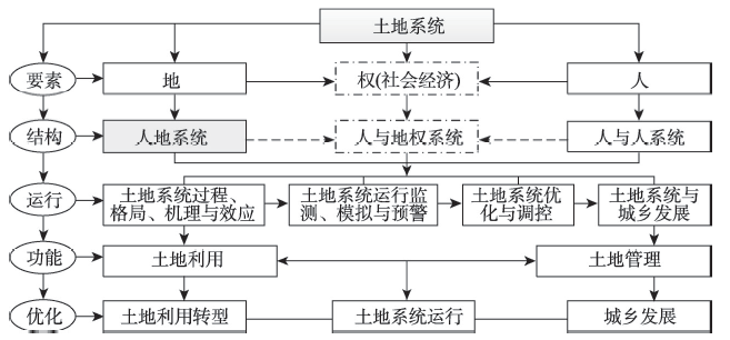
The research perspective of land system science can provide a reference for the study of urban-rural integrated development promoted by land use transitions. Based on the review of the development of land system science, this paper discusses the theoretical framework concerning land use transitions affecting urban-rural integrated development guided by land system science, the influential ways and paths of land use transitions on urban-rural integrated development, and the measures of promoting urban-rural integrated development via adjusting and controlling land use transitions. Land system science is committed to monitoring land use change, explaining the driving forces and feedback mechanism, understanding the human-environment interactions occurring on land, and translating scientific findings on land system into solutions for sustainable land use. The operating of land system takes sustainable land use and human well-being as the criterions, and manifests as multi-dimensional effects of land use. Operating well the land system via scientifically adjusting and controlling land use transitions can affect the process of urban-rural integrated development. Land use transitions promote the integrated development of urban and rural areas under the effects of strengthening the whole and reinforcing weak links through four channels, i.e., efficiency improvement, value embodiment, development elements circulation and structure optimization. In order to promote the integrated development of urban and rural areas from the perspective of land system science, the adjustment and control of land use transitions need to reshape the land use rights system, to promote the integrated consolidation of territorial space, and to improve the management and control system of land use transitions.
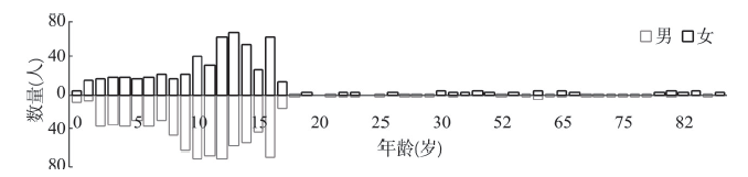
The problem of missing persons brings about serious harm to their families and the society. An in-depth investigation of this issue is of great importance to protecting human lives and human rights. In this research, we collect the missing persons data during the period from 2015 to 2019 from the "China's Child Safety Emergency Response (CCSER)" platform. We use a series of techniques including text analysis, mathematical statistics, and spatial analysis to analyze the socio-demographic characteristics, evolution and formation mechanism of spatio-temporal patterns of missing persons in China. Major findings include: (1) The number of missing males is larger than that of missing females. The highest missing rate is found in people aged 8-16, followed by aged 2-7, aged 0-1, and aged 60-65. Three categories of missing persons are observed in the data, which are (in order of decreasing frequency): unconscious disappearance, active disappearance, and passive disappearance. Six sub-types of missing persons in a descending order by frequency are: running away from home, wandering away, abduction, physical or mental illness, losing track, and family dissension. (2) Hump-shaped curves are observed for temporal variations of the number, gender and age of missing persons, and the curves are symmetric about the year of 2017. The local spatial autocorrelation tests indicate that incidents of missing persons generally exhibit "low-high" and "high-low" clustering patterns. Provinces with a high incidence of missing persons are Guangdong, Zhejiang and Sichuan. (3) With respect to the spatial mobility of missing persons, intra-provincial mobility is more prevalent than inter-provincial mobility. Guangdong, Sichuan, Henan, and Jiangsu experience the highest intra-provincial mobility rate. Dominant paths of inter-provincial mobility are "Anhui-Jiangsu" route and "Guangxi-Guangdong" route. (4) The underlying mechanism of missing person incidents can be understood from the perspective of "strong and weak ties in social network". That is, the strentgth of people's social ties can impact the occurrence of missing persons.
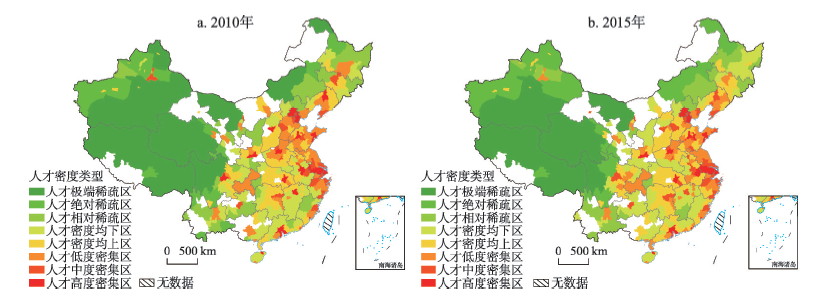
Talents are the core driving force for regional innovation and development, and they are also the key to urban competition in the future. Based on the data of the sixth population census and the national 1% population sampling survey in 2015, this paper uses the concentration index (CI), Gini index (GI) and several related spatial analysis methods to examine the spatial patterns of highly educated talents across China and the drivers behind these patterns from 2010 to 2015. The results are as follows: (1) Talents show highly concentrated and unbalanced spatial distribution patterns at the city level over the five years, but the trend of concentration and imbalance has gradually eased. Results from standard deviation ellipse (SDE) indicate that the distribution direction of highly educated people is "NE-SW". Furthermore, there is a significant spatial spillover effect in the distribution of talents, with three major urban agglomerations of China as the highlands. (2) Economic opportunities are the dominant drivers for the distribution of highly educated talents in China. Among them, wages are the core driver, and gross GDP and industrial structure of each city also exert a significant impact. (3) After controlling the impacts of economic opportunities, local quality variables represented by basic public services (e.g., education and medical care), transportation accessibility and urban consumption facilities play an important role in the distribution of highly educated talents. (4) There are significant differences between the driving factors for talents in urban agglomerations and non-urban agglomerations: economic opportunities are the main driving force for the distribution of talents in both urban agglomerations and non-urban agglomerations, while local qualities including education, consumption, transportation and natural environment have a more significant impact on the distribution of talents in urban agglomerations. This study provides references for the formulation of urban and regional talent policies and regional development policies.
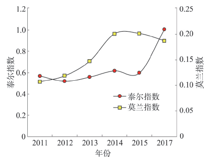
The employment of disabled people is one of the important indicators that guarantee social integration. In this paper, a spatial econometric model is used to make a systematic analysis of the impact of economic condition, government policies, level of education, and the degree of disability and rehabilitation service level of disabled persons on the employment level of disabled Chinese citizens. Using the Theil index and spatial autocorrelation analysis, this article comprehensively assesses the employment level and spatial differentiation characteristics of disabled people in China over the period 2011-2017. The results showed that, first, economic condition, government policies, and educational level of the disabled are positively correlated with the increase of their proportional employment, while the degree of disability showed a negative correlation with the employment rate. Second, the regional differences in the proportional employment level of disabled people were expanded to reveal the agglomeration characteristics. The Getis-Ord Gi* indicated that the distribution of hot and cold spots in the employment level of disabled people was uneven, and that the spatial dual structure was obvious. Third, the employment of disabled persons showed a distribution pattern of "three clusters and four zones", which was mainly a reflection of the decreasing trend in employment level from the eastern coastal region to the western inland region. The structure of the three major urban agglomerations, namely, Beijing-Tianjin-Hebei region, Yangtze River Delta, and Pearl River Delta, which are also known as employment-intensive areas, showed a high degree of consistency. Fourth, accelerating the development of local economy, strengthening government support, and increasing educational opportunities for the disabled were suggested to enhance China's proportional employment of disabled people.
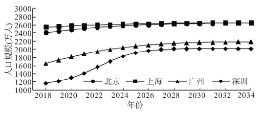
Continuous population growth is an important factor affecting the development of megacities. Optimum population can advance the rational allocation of urban resources amidst the continuous growth. By taking the optimum population as a pointcut, this study first uses the possibility-satisfiability (P-S) model to calculate the optimum population size of Beijing, Shanghai, Guangzhou and Shenzhen in 2035, and then uses the grey back propagation neural network model to predict the resident population of all the four first-tier cities in 2035. Finally, it analyzes all the cities' allocation and planning of resources or infrastructure based on the results, and proposes optimum resource allocation to address an unexpected population growth. The results show that: (1) When the P-S degree is 0.6, the optimum population size of Beijing, Shanghai, Guangzhou and Shenzhen in 2035 is 21.5269 million, 23.0968 million, 14.9893 million and 13.5219 million, respectively, all below the red line of government planning. (2) The resident population of Beijing, Shanghai, Guangzhou and Shenzhen in 2035 will exceed the moderate population size and the red line of government planning, while the moderate population size will be lower than the red line of government planning, and the red line of government planning will be lower than that of the resident population. (3) From the perspective of optimum population, in order to cope with future population growth without affecting economic and social development and residential satisfaction, in 2035, the power generation and green areas of Beijing are expected to reach twice the current levels; power generation, green areas, and public transport vehicles of Shanghai will be 2.27, 2.22 and 2.35 times the current levels, respectively; the energy supply and power generation of Guangzhou are expected to reach three times the current levels; the energy supply, power generation, and the number of beds in health institutions of Shenzhen will be three times the current levels. This study provides a scientific basis for coordinating the sustainable development of population and urban resources in large cities.
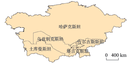
Central Asia was the main thoroughfare of the ancient Silk Road and is the core hub of the Silk Road Economic Belt. The healthy urbanization process in Central Asian countries will inevitably play a significant role in promoting regional socio-economic progress. In the context of the accelerated development of the Silk Road Economic Belt, it is necessary to conduct in-depth research on the urbanization of Central Asian countries. However, the current research does not focus enough on the urbanization of Central Asia; in addition, there is a lack of research on the outward force of urbanization in the era of globalization. This paper analyzes the spatial and temporal patterns and evolution of urbanization from 1991 to 2017, since the independence of the five Central Asian countries, by establishing an evaluation index system at the level of comprehensive urbanization. A fixed-effect panel data regression model is used to analyze the dynamic factors of comprehensive urbanization from the perspective of "internal-external force". The results are as follows: (1) The urbanization process of Central Asian countries is significantly influenced by the political and economic situation and presents periodic characteristics. All the five countries experienced a stagnation development stage at the beginning of independence and a rapid growth stage after the beginning of the 21st century. (2) The differences in the urbanization of Central Asia are obvious, and the evolutionary characteristics of each subsystem of urbanization are different. It is necessary to distinguish and clearly understand the urbanization process of each country in Central Asia. (3) Internal and external factors play a role in the urbanization process of Central Asian countries. The external railway transportation facilities are particularly important for the development of urbanization in these countries. The two outward forces of import and export trade and the introduction of foreign capital have a significant impact on urbanization. (4) Countries with smaller populations and economic scales should participate in international cooperation to promote the healthy development of urbanization. The results of the study indicate that internal and external factors work together in the urbanization process of Central Asian countries, and external forces are particularly important for the development of such urbanization. Central Asian countries need to drive the healthy development of urbanization by establishing high-quality and comprehensive external contacts. The Silk Road Economic Belt supports joint construction and sharing. Therefore, the development of multi-faceted international cooperation with China will bring about advantageous opportunities for the development of urbanization in Central Asia.
The jobs-housing relationship is an important research field to understand the spatial structure of urban functions and reveal the law of urban growth and evolution. In the paper, we first established a framework and a hypothesis model to analyze the jobs-housing relationship from the perspective of residents' life practice and their perception. Based on survey data of residents' perception in Beijing, we analyzed the formation mechanism of the jobs-housing spatial relationship from two aspects of influencing factors and driving mechanism by means of structural equation model. The results show that: (1) housing prices and housing affordability played a critical role in residents' decisions on jobs-housing location. Compared with the material living environment, the non-material factors, such as policies and systems, neighborhood conditions, residents' conception and development expectations, had more significant impact on the formation of the jobs-housing spatial relationship. (2) Land supply and household registration system formulated by the government, the circle-sprawling expansion and industrial spatial transfer in urban spatial structure evolution, the employment distribution and real estate premium under the market mechanism, as well as residents' income and cultural value orientation were the micro-dominant driving factors. (3) The government played a leading role in the formation of residents' jobs-housing spatial relationship in Beijing. Urban spatial reconstruction was the intermediary for the government to transmit information to the market. The market played a role of booster for the real estate premium and the aggravation of jobs-housing imbalance. The residents actively adjusted or were coercively adapted to the jobs-housing location. At the same time, the situation of the jobs-housing relationship could be transmitted to the government and market through the residents' appeal. The government may formulate some policies to prevent the excessive rising price of real estate and strengthen the construction of transportation facilities. The conclusions have enriched the study on the formation mechanism of jobs-housing spatial relationship in megacities in China, and are valuable for the planning of housing, transportation and public service supply in Beijing.

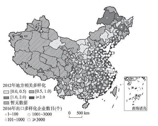
Firm related diversification is a common strategy for emerging economies to promote growth. As evidenced in the rapidly expanding economic literature, a host of internal factors such as residual resources, firm scale and capital structure are important for firm product diversification. However, there has been a dearth of economic researches on the external factors of firm product diversification. Based on such consideration, this article investigates the influence of local related variety on firm's export diversification strategy and explores the moderating effects of regional institutions by estimating tobit model based on the trade data of China's 31 provinces during 2012-2016. The results show that: (1) local related variety has a significant impact on firms' export diversification strategy. Specifically, firms located in regions dominated by related varieties are more likely to show related diversification patterns of export products. (2) Besides, the relationships between firm routines and local related variety are different in varied institutional contexts. For example, the regional atmosphere of trust is one of the most important informal institutions. This paper finds that the atmosphere of local trust will strengthen the relationship between firms' related diversification patterns and local related variety significantly. As for formal institutions, we find different moderating effects of regional marketization, globalization and decentralization. Marketization's moderating role is positive, while regional process of globalization and decentralization exerts a serious negative impact on the consistency of regions and firms in diversification patterns. According to the above results, this paper attempts to redress the neglect of regional institutions and forge a link between the economic and geographical investigations which helps to offer a broader view on the external factors of firm related diversification. It also points out that there is a complex relationship among local export variety, regional institutions and firm related diversification. Chinese government should promote local firm's contacts by preferential policies and create new opportunities for local industrial development.
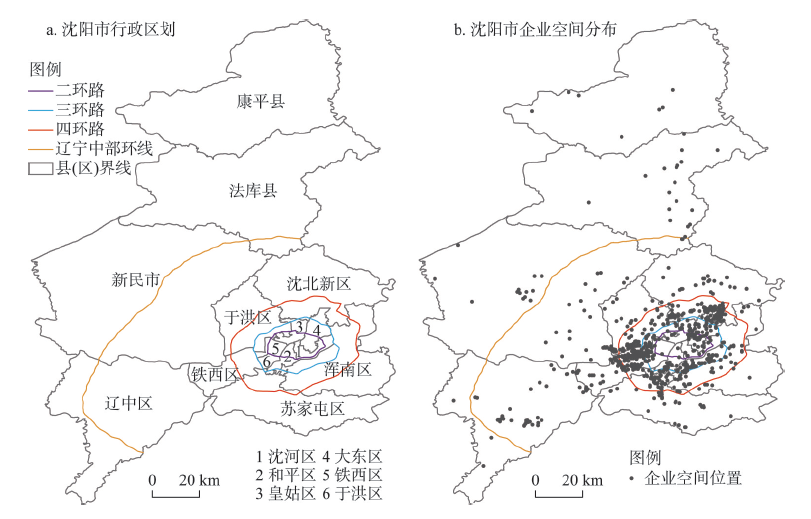
In the era of China's New Normal, compared with other regions in China, the Northeast region has been in obvious economic downturn featured by its weak adaption, or in other words, weak regional economic resilience. However, there is a lack of study on how middle or micro economic sectors, particularly industries and enterprises could shape the resilience level of regional macro economy. This paper, therefore, tries to fill this gap by analyzing the multi-level characteristics of Shenyang's economic resilience since 1978, with regard to its economic growth, industrial restructuring, and enterprise spatial dynamics. We found that affected by China's development status, resilience level of Shenyang's economy shows a weak-strong-weak cycle, driven by the fluctuation of its secondary industry. There are obvious differences in the resilience level of old and new paths in Shenyang. In particular, due to its low competitiveness, the resilience level of mechanical industry in old paths has weakened and imposed greater impacts on secondary industry. Meanwhile, the survival rate of old and new enterprises indicates that the resilience level of old paths enterprises is stronger than that of the new paths ones under the context of national economy slowing down; except for enterprises in food industry, the resilience level of old enterprises is stronger than that of the new ones. Moreover, this research indicates that new enterprises of technology-intensive industry such as the old paths and the electronic industry in new paths show a spatial path dependence of city center, and spatial agglomeration has positive effects on enterprises' survival.
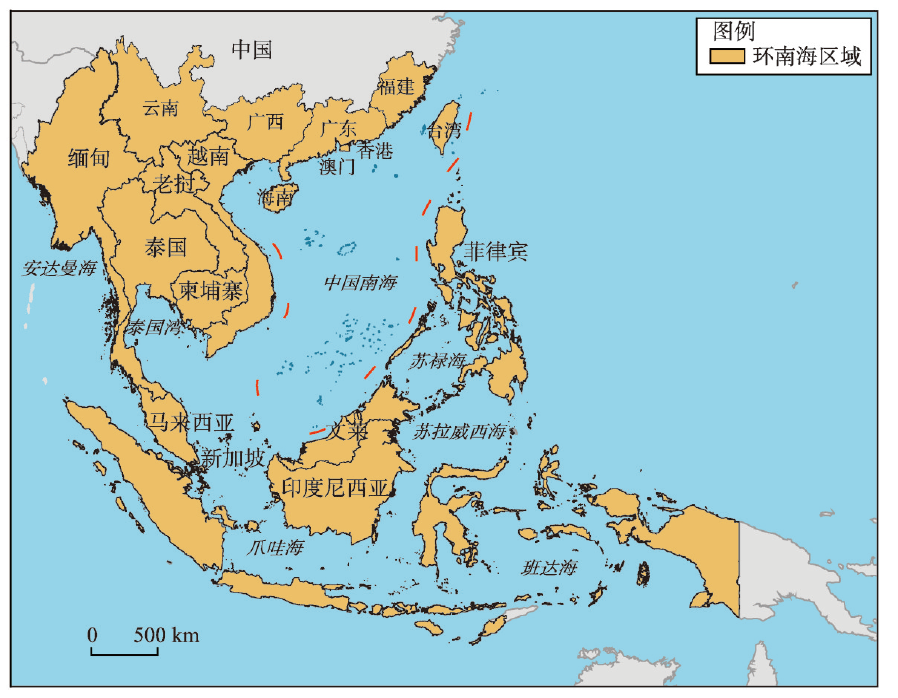
The Belt and Road Initiative (BRI) of China is sharply catalyzing the evolution of the global economic landscape. In order to cope with these great changes, China needs to take South China Sea Region (SCSR) as its strategic pivot and explore the construction possibility of a strategic integrated economic zone combining China and ASEAN. Based on key indicators, this paper outlines the overall development characteristics of SCSR, analyses the structural characteristics of industry and trade based on the indexes of industrial structure similarity and trade structure coincidence, depicts the spatial network characteristics of the core growth area around SCSR, and discusses the construction prospect of multiple integrated economic zone in SCSR. The results show that: (1) From 2000 to 2017, the main economic indicators of SCSR grew pretty well, the development speed and quality were much higher than the global average level in the same period. (2) Driven by the global industrial transfer stages and spatial paths, SCSR has evolved into four levels, the first level includes Macao, Singapore, and Hong Kong, the second level includes Guangdong, Fujian, Taiwan, Brunei and Malaysia, the third level includes Yunnan, Guangxi, Hainan, Thailand, Indonesia, Philippines and Vietnam, the fourth level includes Myanmar, Laos and Cambodia. (3) The indexes of industrial structure similarity and trade structure coincidence of 11 countries in SCSR keep at a high level, which do not only show the integration trend from the horizontal and vertical dimensions, but also from the upgrading and downgrading states. (4) SCSR has formed nine core growth regions, and the advantage industries and export commodity types between different regions are characterized by convergence and complementarity due to the polarization and diffusion effect of the growth poles. (5) From a long-term perspective, SCSR has had the external and internal conditions for building a multiple integrated economic zone. The 5th round of global industrial transfer and the reconstruction of the global value chain will build a production-consumption network which can match the characteristics of regional resource endowments, while the spatial network will be built by spatial entities such as urban agglomeration and high-speed transportation, and the cooperation policy platform from internal and external conditions will better guarantee the construction of the multiple integrated economic zone as well.
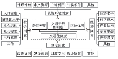
Traffic facilities are important resources for the future sustainable development of old industrial areas. It is of great practical significance to evaluate and study the spatiotemporal differentiation laws and mechanisms of traffic dominance. A comprehensive evaluation method based on traffic network density, traffic trunk line influence degree, and location dominance was constructed to measure traffic dominance. Taking Northeast China as the case study, the influencing factors and mechanisms of the overall pattern of traffic dominance were analyzed through network analysis, multivariable linear regression and geographic weighted regression. The results show that: (1) The overall traffic dominance of Northeast China is on the rise, and its spatial distribution pattern takes Harbin-Dalian line as the axis and presents a "core-periphery" structure. (2) The spatial differentiation of the overall traffic dominance of the study area is obvious. Most of the high value areas are concentrated along the high-speed railways, while the low value areas are mainly distributed in the east of Inner Mongolia and the north of Heilongjiang. The spatial difference is increasing gradually. (3) The fast traffic mode contributes a lot to the traffic dominance of Northeast China, and the influence of population carrying capacity on the spatiotemporal differentiation of traffic dominance is gradually strengthened. Expanding the traffic trunk lines and increasing the number of traffic hubs will help to improve the traffic dominance of Northeast China.
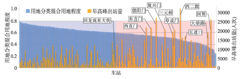
The integrated development of urban rail transit and land use nearby is one of the most important issues for sustainable development of cities. To improve the sustainability of urban rail transit and the rationality of land resource allocation, it is of great importance to understand the dependence relationship between passenger flow of urban rail transit and functions of land use. Regression analysis is the main method to study this relationship. However, the descriptions of land use in existing research are mostly based on sketchy data such as land area, which is difficult to reveal the impact mechanism and spatial effects of land use of various attributes on passenger flow. To this end, this study utilizes Point of Interest (POI) data of Baidu Map to describe land use information, and proposes a fine-grained description method of land use function within the attraction scope of urban rail transit station. Based on the case of Beijing Subway, global regression models with constant parameters and local regression model with variable parameters are employed to study the dependence relationship and spatial effects of coarse and fine-grained land use with outbound passenger flow at morning peak. The case study of Beijing Subway shows that comprehensively considering the tradeoff between the explanatory power and complexity of models, and the effect of dealing with spatial dependence and heterogeneity, the geographically weighted regression (GWR) model with variable parameters has the best estimation compared with the global model with constant parameter. Its interpretation ability is 84%, and Moran's I index of residuals is 0.0001, which can describe the spatial heterogeneity of the dependence of station outbound passenger flow and POI. The results also display that the Beijing's urban rail transit station basically covers the social and economic center of the central city. These areas are usually developed in a high-intensity hybrid manner for land development. Moreover, the impact and spatial characteristics of land use with different attributes and functions on the morning peak outbound passenger flow are significantly different. For example, the morning peak outbound passenger flow is closely related with the land for commercial and business facilities, administration and public services, which are related to housing and employment, and the commuter between the two places. At the fine-grained level, the outbound passenger flow is more dependent on POI of office buildings and government agencies, which are significantly distributed in the central city functional areas and urban core areas with dense employment. The local model with variable parameters based on fine-grained POI can better identify the impact and spatial heterogeneity of various types of land use on station passenger flow. The case study indicates that the dependence of station passenger flow and land use is the superposition of impacts and spatial effects of various attribute functions of land use.
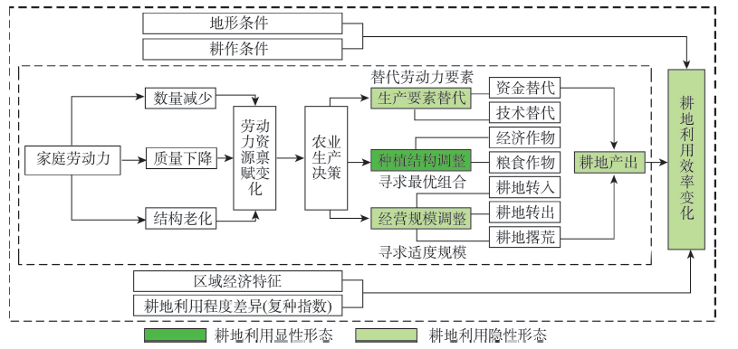
Land use morphology is the core content of land use transition research. Farmers' land use decision is a deep factor that causes the change of land use system and land use transition. At present, scholars have carried out a series of theoretical and empirical studies on the morphology of farmland use from multiple perspectives, but there are few studies concerning the recessive morphology and its forming mechanism of farmland use from the perspective of farmer household. In order to reveal the differences of recessive morphology of farmers' farmland use and their influencing factors, this paper measured the farmland use efficiency from the perspectives of farmland use efficiency, labor changes and agricultural production decision-making of farmer household based on the survey data of farmer households in Shouguang and Yiyuan, and probed the driving mechanism of farmland use efficiency of farmer household by constructing a structural equation model. The results show that the farmland use efficiency of Shouguang and Yiyuan is low, and there are differences in geomorphological type and farmer type. The efficiency of farmland use in the plain area is slightly higher than that in the mountainous area, and the farmland use efficiency of elderly farmers is lower than that of young farmers. In terms of impact path, farmers' management scale and production factor input as well as farmland output can directly affect farmland use efficiency, while the planting structure has no significant influence on farmland use efficiency.
The theory on the cyclic adaptaion between society and ecosystem sheds new light on the evolution and internal structure of human-land system. This paper introduces the risk index (RI) and adaptation capacity index (ACI) to evaluate the rural human-land system, and sets up an evaluation index system for the adaptability of rural human-land system, under the effects of climate change and policy implementation. On this basis, the stages, features, control factors, and evolution mechanism were examined for the adaptability of rural human-land system in Darhan Mumingan United Banner from 1952 to 2017. The main results are as follows: (1) The evolution of the rural human-land system can be divided into three stages, namely, the reorganization and rapid development stage from 1952 to 2002 (population: +260%; cultivated land area: +13%; livestock: +134%; degradated grassland area: +16.33%), the rapid to stable development stage from 2003 to 2010 (population: +2.8%; cultivated land area: -2.3%; livestock: -13.6%; degradated grassland area: -10.7%), and the stable to release stage from 2011 to 2017 (population: -2.6%; cultivated land area: -0.2%; livestock: -10.6%; degradated grassland area: -3.8%). (2) With the elapse of time, the ACI of the rural human-land system went through a slow rise (-0.016-0.031), a slow decline (0.031-0.003), and a rapid rise (0.003-0.088). In terms of space, the adaptability is high in the middle, moderate in the north, and low in the south. (3) The adaptability evolution of the rural human-land system was mainly controlled by the per-capita effective irrigation area (22.31%) and the per-capita number of livestocks (23.47%) from 1990 to 2000, the desertification area of land (25.06%) and the land use intensity (21.27%) from 2000 to 2005, and the per-capita income of farmers and herdsmen (20.08%) and the per-capita number of livestocks (18.52%) from 2010 to 2007. (4) Under the effects of climate change and policy implementation, the cyclic adaptaion of the rural human-land system was propelled by the interactions between two kinds of subjects: farmers and herdsmen, and rural communities. The interaction affects the adaptive behavior of the two kinds of subjects, which in turn drives the cyclic evolution of the system. As a result, the system structure and functions developed alternatively between coordinated and uncoordinated states. Small-scale adaptive behaviors of farmers and herdsmen have a profound impact on the evolution of rural human-land system.