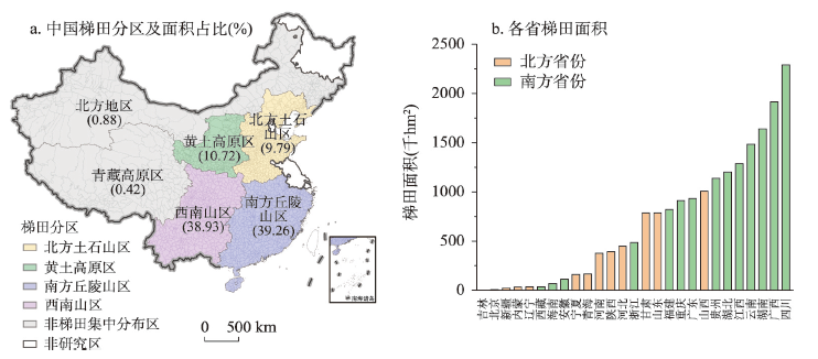
With urbanization and industrialization, cultivated land in hilly regions of China has been gradually marginalized. Abandoned cultivated lands have ranged from inferior sloping land and extended to high-quality terraces. The abandonment of terraces will lead to a series of social and ecological problems, especially with large-scale abandonment. Therefore, the degree and spatial distribution of terrace abandonment should be evaluated scientifically to address the issue of abandonment as well as its effects. This study investigated the extent of terrace abandonment in China via a questionnaire sampling method. Based on 560 village questionnaires from 329 counties in China, the scale of terrace abandonment was calculated and the spatial heterogeneity characteristics and primary reasons for terrace abandonment were further analyzed. Study results showed that: (1) The phenomenon of terrace abandonment was observed throughout China, occurring in 54% of all the villages investigated; 9.79% of the total terraced areas have been abandoned. (2) The degree of terrace abandonment showed a spatial pattern of "high in the south and low in the north". The degree of terrace abandonment was higher in the southern hilly mountains, and the middle and lower reaches of the Yangtze River was the most serious. (3) The primary factors related to terrace abandonment were found to be labor migration, the degree to which terraces have been mechanized, irrigation conditions, and farming traffic conditions. Measures that include improving the degree of terrace mechanization should be enacted to address the problem of terrace abandonment. An orderly "conversion of cropland" could be applied to poor-quality terraces. Changing the planting structure, strengthening new agricultural infrastructure, and encouraging circulation and large-scale operations are options that could be applied to good-quality terraces.
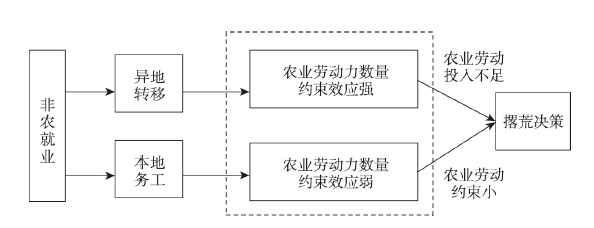
Frequent terrace abandonment in hilly and mountainous areas has become a great concern for Chinese agricultural sector and academia in recent years. However, few studies concern about the impact of differences in agricultural labor transfer on farmers' terrace abandonment behavior. Taking Hunan, Fujian and Jiangxi provinces, where terraced fields are widely distributed, as study areas, this paper adopts Probit and Tobit models to analyze the impact of quantity, distance, and quality of labor off-farm transfer on farmers' terrace abandonment behavior and scale from the perspective of labor transfer difference based on survey data of 1438 households. The research shows that: (1) The quantity, distance and quality of off-farm labor transfer significantly positively impact farmers' terrace abandonment behavior and scale. (2) The scale of terrace abandonment in hilly and mountainous areas expands with the deepening of farmers' off-farm transfer. (3) The spatial distance and quality of labor transfer strengthen the impact of labor transfer quantity on farmers' terrace abandonment behavior. To alleviate terrace abandonment resulting from labor off-farm transfer, attention should be paid to the labor substitution effect of agricultural service outsourcing and mechanization in mountainous areas. It is suggested to promote the adaptability of agricultural machinery in mountainous areas, improve farmland transfer market, and encourage farmers to transfer terraced fields.
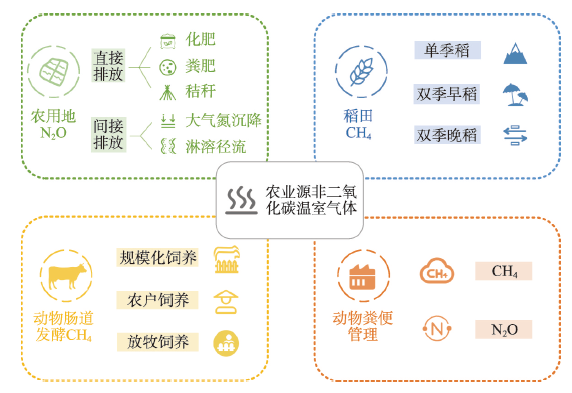
It is practical to control agricultural non-CO2 greenhouse gases (GHG) emissions for the implementation of greenhouse gas mitigation policies in China, and has a guiding value for promoting the green transformation of agriculture and realizing rural revitalization. Based on the IPCC coefficient method, this paper accounts for the provincial agricultural non-CO2 GHG emissions in China from 2000 to 2019, and portrays the spatial and temporal evolution patterns of agricultural non-CO2 GHG emission intensity. Based on the STRIPAT model, the influence mechanism of agricultural non-CO2 GHG in each region is analyzed, and the future evolution of agricultural non-CO2 GHG under different scenarios simulated. The results show that: (1) Methane emissions from animal enteric fermentation are one of major sources of agricultural non-CO2 greenhouse gases in China, and agricultural non-CO2 GHG emissions in China gradually shift from the eastern coast to the western inland regions. (2) The Hu Huanyong Line is the divide between the emission intensity per unit of agricultural value added and the high value zone per unit of agricultural land area, and the agro-pastoral intersection zone is the high value zone of emission intensity per unit of agricultural value added in China. (3) The relationship between agricultural non-CO2 GHG and per capita GDP in China has an inverted "N" type Environmental Kuznets Curve (EKC), and North, Northeast and Central China are still under pressure to reduce emissions. Effectively reducing methane emissions from animal enteric fermentation and formulating localized emission reduction policies based on regional development characteristics are the keys to reducing agricultural non-CO2 GHG in China in the future.
To realize carbon‐related nationally determined contributions and achieve the targets of carbon peak and carbon neutrality on schedule, low-carbon development of China's service industry is an inevitable trend. On the basis of the comprehensive application of multiple spatial analysis methods, the spatiotemporal evolution and dynamic interaction characteristics of carbon intensity in China's service industry from 2005 to 2019 are analyzed from the perspective of spatiotemporal interaction. Combined with quantile regression and the nested model of spatiotemporal transition, the driving mechanism patterns of carbon intensity in China's service industry under different transition types are revealed. The results are as follows: (1) The carbon intensity in China's service industry first increased and then decreased from 2005 to 2019, showing spatially unbalanced characteristics. (2) The kernel density curve demonstrates the dynamic convergence trend of regional differences in the carbon intensity of the service industry. And the carbon intensity also showed a significant spatial agglomeration phenomenon according to the spatial autocorrelation analysis. (3) Based on the evolution analysis of the spatial correlation pattern of carbon intensity in the service industry from 2005 to 2019, a path-locking feature was shown by few spatiotemporal transitions across different types. The eastern coastal region had relatively stable spatial structure and spatial dependence direction, while the central and western regions demonstrated the opposite. (4) The spatiotemporal network pattern of carbon intensity in China's service industry was dominated by positive correlations, although a certain degree of spatiotemporal competition was found between some neighboring provinces. (5) Regional differences existed in the spatiotemporal transition driving patterns of carbon intensity in China's service industry. Specifically, the eastern coastal provinces were mainly influenced by the population-urbanization restriction mode, while most regions in the northwest, southwest, and northeast were mainly influenced by the driving pattern of technology-regulation. From the northwest to the southeast, the spatiotemporal transition patterns showed an evolutionary characteristic of "synthetic development-synthetic restriction". Therefore, the formulation of the emission reduction policies should not only consider various driving/restriction factors but also emphasize differentiated emission reduction measures in China's service industry by combining different types of carbon intensity agglomeration and transition paths, as well as avoiding the regional closure of inter-provincial emission reduction policies through synergistic emission reduction.
Based on the tree-ring increment cores of Juniperus przewalskii Kom. collected from the Maoniu Mountain in inner Qaidam Basin, the new 2710-year tree-ring width chronology was developed, and the correlation coefficients were calculated between the chronology and meteorological data during the instrumental period of 1957-2017. The results showed that the highest correlation existed between the total precipitation from July of previous year to June of current year and the chronology (r = 0.753, n = 60, p < 0.01). Based on the correlation relationship, total precipitation variation from July of previous year to June of current year was reconstructed from 392 BC to 2017 AD. The reconstruction explained 64% of the variation in the total precipitation from previous July to current June for the calibration period (1957-2017 AD). The results showed that there were nine wet periods which occurred during 106-75 BC, 6-39 AD, 179-229 AD, 581-646 AD, 823-914 AD, 1026-1095 AD, 1378-1414 AD, 1567-1609 AD and 1985-2017 AD, and seven dry periods occurring during 328-297 BC, 86-151 AD, 694-747 AD, 1168-1199 AD, 1444-1525 AD, 1680-1725 AD and 1792-1860 AD in the past 2409 years. Among these wet and dry periods, 1792-1860 AD was the driest period. Power spectral analysis revealed cyclic fluctuations of the precipitation series on 2~8 years, 40 years, 80 years and 225 years (p < 0.01). In addition, the solar minimum phases were in accord with the dry period in our study area in the past 2409 years, and the results of superposed epoch analysis showed that the precipitation decreased significantly in the following year after large volcanic eruptions observed at low-mid latitudes. The results indicated that solar activity and large volcanic eruptions were factors impacting precipitation variation in our study area.

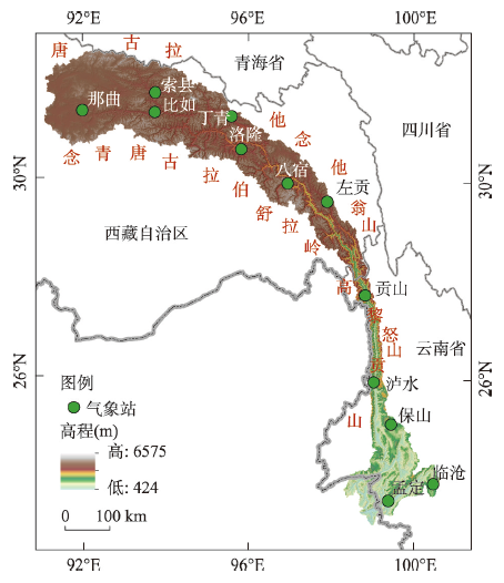
Water vapor transport is a key factor in the transformation of atmospheric water resources to terrestrial water resources. In order to reveal the characteristics of water vapor transport and its influence on precipitation over the Nujiang River basin, high spatial resolution (0.25°) ERA-Interim reanalysis data, TRMM 3B43 Version7 data, meteorological station measured data and SRTM Version4.1 DEM data were used, and a new method to generalize and extract water vapor transport data along the watershed boundary was adopted. Through analysis and research, the multiple branches water vapor transports over the Nujiang River Basin in summer were detected, and their effects on the spatiotemporal distribution of precipitation were analyzed. The research shows that there are four regional high-value areas of water vapor transport on the western boundary of the watershed, which are located in the southern and northern parts of Gaoligong Mountain, the northern part of Boshula Mountain, and the middle of Nyenchen Tanglha Mountains, with the annual average water vapor flux being 102.6 kg/(m·s), 66.3 kg/(m·s), 39.7 kg/(m·s), and 41.3 kg/(m·s), respectively. Multiple branches water vapor transport affects not only the water vapor transport in different areas of the basin, but also the spatiotemporal characteristics of precipitation. In terms of interannual variation, the influence of water vapor transport on precipitation is weaker in the middle and downstream area (Hengduan Mountains), while it is greater in the upstream area (Qinghai-Tibet Plateau), especially in the Nagqu-Biru-Suoxian area. In terms of spatial distribution, annual precipitation in the basin is significantly positively correlated with water vapor flux and negatively correlated with water vapor flux divergence. Because of multiple branches of water vapor transport, four regional rainy areas are formed by the west side of the basin.
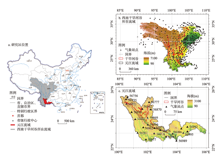
Significant spatial heterogeneity of precipitation distribution can be observed over complex terrains. As a result, the spatial representativeness of ground-based precipitation observations, the applicability of remote sensing and reanalysis products, and the reliability of traditional interpolation methods are largely limited. PRISM (Parameter-elevation Regressions on Independent Slopes Model) has been widely used for precipitation interpolation. It interpolates the precipitation observation data by extracting and weighting topographic elements, and further introducing them into the regression of precipitation-elevation relationships through the weighted least square method. However, traditional PRISM is not capable of reflecting relatively small-scale topographic features. Thus, based on the analysis of impact mechanism of topographic factors on precipitation patterns over complex terrains, this study aimed to improve the calculation and weighting process of PRISM topographic elements, and integrate the modified PRISM into the "climatological-ratio" interpolation framework considering the random noise in actual daily precipitation observations and finally propose an interpolation framework, MPRISMR. Taking the Yuanjiang River Basin with typical complex terrains as an example, we verified the feasibility and reliability of MPRISMR for daily precipitation interpolation based on the "leave-one-out" cross-validation and by comparing with the ERA5-Land and TRMM_3B42 precipitation products. The results showed that over 23 observation stations in the Yuanjiang River Basin, the performances of daily precipitation interpolation results based on MPPRISMR were better than those on the basis of both ERA5-Land and TRMM_3B42 precipitation products. Specifically, the verification evaluation index results showed that the medians of the Pearson's correlation coefficient and relative bias of the MPRISMR results were 0.72、0.98%, respectively. Besides, compared with ERA5-Land and TRMM 3B42 precipitation products, the accuracy of MPRISMR precipitation interpolation results changed less with time and therefore it was more stable. Thus, the applicability of the MPRISMR for high-resolution daily precipitation interpolation and the feasibility of using the result data as the input of relevant models were demonstrated. Finally, daily precipitation grid data covering the study area from 2000 to 2018 with a spatial resolution of about 3 km were generated based on MPRISMR. The developed MPRISMR algorithm can provide foundational precipitation data for land surface, hydrology, and water quality models, and support scientific management and policy-making decisions over complex terrains.
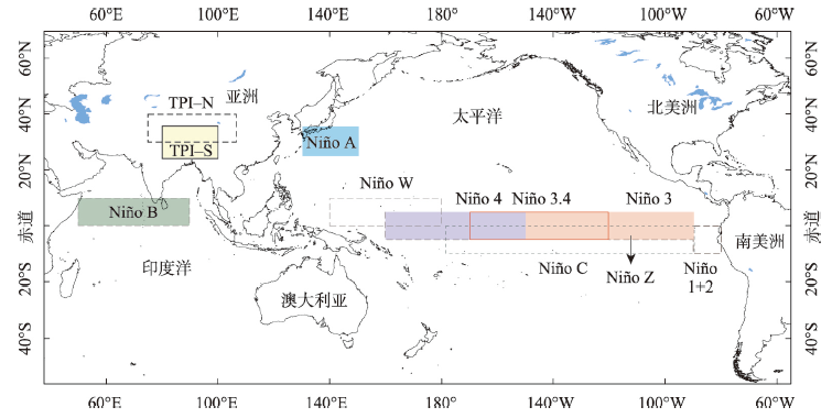
It is a hot issue in climate change research to study the response mechanism of mountain snow cover to climate warming based on elevation-dependent warming. Based on Terra Moderate Resolution Imaging Spectroradiometer (MODIS) snow cover phenology datasets from 2000 to 2019, we analyzed the spatiotemporal variation of snow cover days in the north and south of the Qinling Mountains by the methods of trend and detrended correlation analysis. Meanwhile, we identified the influencing factors of snow cover days from the perspectives of sea surface temperature (SST) in autumn and winter of the equatorial Pacific, high pressure over the Qinghai-Tibet Plateau, respectively. The results are as follows: (1) after 2013, climate condition in the north and south of the Qinling Mountains shifted from "warming hiatus" to "warming up", followed by declining snow cover days. And the proportion of areas with snow cover more than 10 days decreased from 35.1% to 8.6%. (2) We identified 1950-2000 m in the Qinling Mountains and 1600-1650 m in the Daba Mountains as transition zones of snow cover days. Above the transition zone, the increasing rate of snow cover days with altitude is higher than that of the low altitude area. Particularly, the altitudinal belt between 2100 m and 3150 m is the sensitivity zone of snow cover days to climate change. On the basis of the reference period of 2000-2004, we find that the elevation with 40, 60 and 80 days of snow cover increased by 100 m, 100 m and 150 m for the period of 2015-2019. (3) The SST in autumn and winter over NINO C and NINO Z regions and the winter high pressure over Qinghai-Tibet Plateau are two effective indicators of snow cover days anomaly in the Qinling Mountains, Hanjiang Valley and Daba Mountains. The lower SST of the central equatorial Pacific in autumn and winter, or the lower the winter high pressure over the Qinghai-Tibet Plateau is, the more excessive snow cover days would occur. (4) In terms of circulation mechanism, during the years with more snow cover days, the 0 ℃ isotherm in January and February was southerly, providing the proper temperature for increasing snow and ice accumulation and delaying snow and ice melting. Moreover, there was a weak water vapor convergence zone in January, which provided water vapor conditions for increasing snow and ice accumulation. The findings can enrich our understanding of winter climate change and provide early warning information of snow anomaly in the subtropical and warm-temperate zones in China.
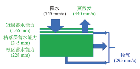
Water retention plays a critical role in terrestrial ecosystem service. However, regarding its definition and calculation, there is a long debate in academia, which illustrates its importance in practice, and simultaneously demonstrates the complexity and vagueness of this essential concept. Thus, there is an urgent need to clarify its definition and calculation method based on basic ecological and hydrological theories, and eventually promote science-based decision-making and integrated water management. Interestingly, we observed that for the same term of "water retention function", ecologists intended to concern the terrestrial ecosystem's water storage capacity (Smax), while hydrologists concerned more about the water yield from the catchment (Q). Both perspectives have their own rationality, but with totally different vision and emphasis. By theorical discussion and data analysis, we found that water storage capacity (Smax) and water yield (Q) indeed have strong connection, but they are definitely two different concepts. The Smax of terrestrial ecosystem determined the separation of precipitation into either evaporation (green water) and Q (blue water). The size of Smax in most cases trades off with the amount of Q. We further revealed that the root zone storage capacity (SRmax) of ecosystem is at the heart of water retention function assessment, and plays a key role linking blue and green water. The SRmax is the result of ecosystem's adaption to its climate, and can be derived by the classic method to design reservoir, i.e. the Mass Curve Technique (MCT). Lastly, we gave three recommendations: (1) simultaneously evaluating green water retention capacity and blue water yield in practice; (2) further investigating the water retention functions of more water bodies, e.g. glacier, snow cover, and groundwater; (3) synergizing natural and artificial water retention capacities to enhance the water use efficiency in both the ecosystem and our economic-social system.
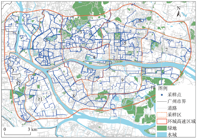
As the main air pollution indicator, PM2.5 concentration often comes from monitoring data of fixed environmental monitoring stations and remote sensing image data. The spatial and temporal accuracy is generally insufficient, which makes it difficult to reveal the spatial and temporal distribution of PM2.5 in urban interior at microscale. In this study, using the mobile monitoring method of cycling, the typical working day (November 27, 2017) was selected to collect PM2.5 concentration data of roads in the main urban area of Guangzhou at a time and space granularity of 1 m·s. The machine learning method is utilized to simulate the refined spatiotemporal distribution pattern of on-road PM2.5 during the morning and evening peak hours. The results show that the average spatial range of PM2.5 concentration values close to each other in the morning peak hours is 24 m, which is larger than that in the evening peak hours of 15 m. There was a microscale spatial and temporal heterogeneity of PM2.5 concentration. The fitting degrees of morning and evening peaks' PM2.5 models constructed by Multilayer Perceptron (MLP) reached 0.70 and 0.68, respectively, which is obviously superior to the traditional Ordinary Least Square (OLS) linear regression model. The model reveals that the average concentration of PM2.5 in the whole road network of the main urban area was 30.19 μg/m3 in the morning peak, and reached 44.55 μg/m3 in the evening peak, with the maximum up to 94.82 μg/m3. The spatial distribution characteristics of "high in the west and low in the east" are significant. The refined mapping method of PM2.5 concentration proposed in this paper has a spatial accuracy of 1 m and can better describe the spatial heterogeneity. The method is proved to be feasible and can provide reference for public health travel and targeted pollution prevention.
In the context of social and economic transformation in rural China, the phenomenon of ecosystem "anti-service" has emerged frequently, and it is a great challenge to synergize ecological conservation and socio-economic development. Using the meta-analysis and collecting 733 typical human-boar conflict incidents (also known as wild boar damage incidents), this paper studies the spatiotemporal patterns, hazards and driving factors of wild boar damage from 2000 to 2021. During this period, the number, spatial scope and hazard degree of wild boar damage incidents showed an increasing trend, and the number of provinces, cities and districts (counties) involved increased from 18, 41 and 67 in the earlier stage to 25, 147 and 399 in the recent period, with corresponding increases of 39%, 259% and 496%, respectively. Among them, wild boar damage incidents were concentrated in Chongqing Municipality and central and western parts of Hubei Province before 2005, and then expanded around, and this situation concentrated in the Sichuan Basin, Loess Plateau, middle and lower reaches of the Yangtze River and hilly mountainous areas such as Changbai Mountains after 2015. The main manifestations were destroying crops, infringing poultry and causing casualties, especially the destruction of crops leading to cultivated land abandonment, accompanied by a rapid increase in casualties, accounting for about 1/4 (23.66%) of the total number of damage incidents. Meanwhile, the spreading trend and harmfulness of wild boar damage is a typical phenomenon of "anti-service" in ecosystem. The aggravation of this phenomenon is the result of ecological restoration, hunting ban policy, unclear boundary between agricultural land and ecological land, strong viability of wild boar and lack of natural enemies. It has posed an obvious threat to the utilization of abandoned cultivated land, the improvement of farmers' livelihood and the maintenance of regional ecological security. It is extremely urgent to formulate the policy of controlling the number of wild boars and establish the compensation mechanism for the loss by wild boars, which is a new social problem that needs to be dealt with urgently in rural revitalization in the new era.
It is a long process for human to shift from highly mobile to year-round sedentary lifeways. Sedentism had a profound impact on the subsistence, technologies, and ultimately the origin of civilization in human societies. The emergence of sedentism was effected by climate change, population growth, resource pressure, technological innovation and so forth. The Tibetan Plateau is a key region to study human evolution and adaptation to extreme environment due to the alpine and hypoxia conditions. How people adapted and permanently occupied the Tibetan Plateau has been a heated debate in the past decades, but the prehistoric process of sedentism on the Tibetan Plateau is still ambiguous. By reviewing the published archaeological and genetics research, we find that current studies of prehistoric human sedentism on the Tibetan Plateau focused on agricultural diffusion from low-altitude to high-altitude areas and its effects; Few attentions were paid to the role of animal resources in the process of sedentism, and the chronological sequence and driving mechanism of sedentism on the Tibetan Plateau are still controversial. Seasonality analysis is crucial to determine whether a site is occupied year-round. We summarized the methods for seasonality analysis using animal remains, and put forward some suggestions on how to efficiently establish the schedule of animal resources utilization at a site according to the local conditions. Firstly, the database of skeletal morphology, whole genome and proteome of modern animals on the Tibetan Plateau should be established to provide a basis for the identification of animal remains from archaeological sites. Subsequently, the human-animal-environment relationship and the role of animal resources in human sedentism process on the Tibetan Plateau should be evaluated.
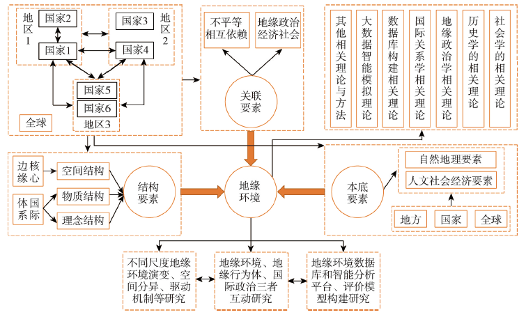
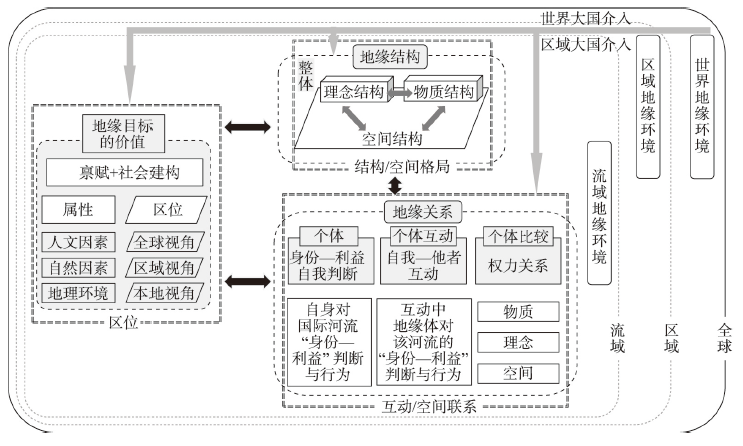
In the past 12 years, geo-setting research has made great progress and become one of the key points in the current domestic geopolitical research, gathering many domestic geopolitical research groups and promoting the revival of China's geopolitical studies. On the basis of summarizing and analyzing the latest developments and trends of geopolitics and geo-setting research in China and abroad, this paper focuses on the idea, agenda and approaches of geo-setting research. Centered on the interactive practices of multiple geo-actors, its idea regards the geo-setting as the "information" or decision-making dataset for their interactive practices, which also results from their interactions. Thus, geo-actors' decisions for actions can be made under complete information, incomplete information, or even when true or false information cannot be distinguished. Under this new thought, the geo-setting research agenda generally includes three items: (1) the analysis of geo-setting elements (including fundamental, relational and structural elements); (2) the spatio-temporal process and mechanism of geo-setting; (3) the design of geo-setting technical system. In order to integrate different fields, various scales and multiple actors, this paper takes the conflict in northern Myanmar as an example to present three approaches of geo-setting research, namely, cross-field interaction, cross-scale coupling and multiple geo-actors' game playing. Under current complex situation of once-in-a-century changes and COVID-19 pandemic, clarifying the idea, agenda and approaches of geo-setting studies is of great theoretical value and practical significance for accurately and scientifically analyzing the current complex situation and proposing China's response strategies.
Along with climate change, population growth and economic development, the contradiction between global water supply and demand had become increasingly prominent, and water conflicts on international rivers would occur more frequently. The Jordan River had been an international river on most serious conflicts in the world. The number of transboundary water conflicts on the river accounted for 1/5 of the global total between 1948 and 2008, what's more, the proportion of war-related transboundary water conflicts reached 2/3. A geo-setting analysis framework for international river transboundary water conflicts was provided, which was composed of the analysis of geo-value, geo-relationship and geo-structure. And it was used to study the geo-mechanism of the Jordan River transboundary water conflicts. The conclusions can be drawn as follows: (1) The geopolitical goals of the Jordan River transboundary water conflicts were concentrated in water-rich areas, from the major water resources areas to the less important ones, because Israel was scrambling for Jordan River water resources area. After Yom Kippur War, Arab countries started to claim Israel for its own territory rich in water resources in the Jordan River. (2) Israel, the core actor in the water conflicts, started nearly 60%of transboundary water conflicts on the Jordan River, Arab countries accounted for 20%, and non-riparian countries took the rest 20%. (3) It was the geo-value of the Jordan River Basin that attracted foreign powers to directly intervene, which escalated water conflicts and benefitted the United States and Israel. The geo-relationship between "water-rich areas" was stronger than that of "water quantity", which had a strengthening effect on the transboundary water conflicts on the Jordan River. Israel, as the hydro-hegemony of the Jordan River, dominated the geo-structure of the river even more, leading to spatial and temporal distribution pattern of the transboundary water conflicts in the basin.
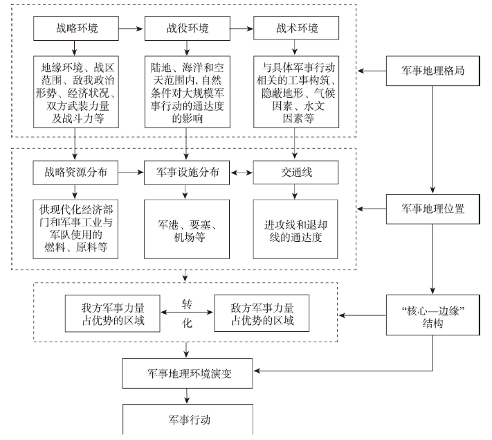
In terms of military geographical environment, the severest threat for the marine security of contemporary China comes from the blockade of the island chains around the country's coastline built by the United States and its allies. It is of obvious practical significance for war preparedness and national defense to study the comprehensive influences of this special geographical environment. This paper focuses on this practical problem and tries to reveal the complex and dynamic relationship between military geography environment and wars and thus proposes a research approach and analytical framework for military geography study from an interdisciplinary perspective integrating history, geography and military science. This process is further illustrated based on the analysis of a specific war case: The German naval operations across the island chain around China at the early stage of the World War I. At the early stage of World War I, German troops in East Asia tried to conduct cross-island chain warfare, but soon defeated by the superior forces of Japanese navy and its blockade relying on island chains. This process had led to a transformation of military geographical position to both sides of this military operation. This paper elaborates this transformation applying the theory of "core-periphery" structure: As a seaport under German occupation, Qingdao had advantageous strategic location and military strength. But it was relatively geographic isolated and lacked strategic depth. From the perspective of macro region, Qingdao as a German navy base was separated with its fleet by island chains built by its enemy, making it easily attacked from both front and rear. On the other hand, it required a large number of troops for Japanese army to carry out the blockade, leading to the weakening of the forces in its border areas. It is precisely in this weakened area that the German East Asia Fleet, which was originally at a disadvantage, found new opportunity and made significant achievement. Thereby, the previous military structure of "core-periphery" was dramatically reversed, forming a new military geographical situation. Finally, this paper put forward five suggestions for the study of maritime security and the construction of China's maritime power.
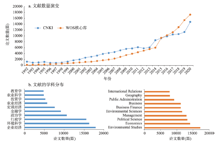
The "Four Orientations" (orienting to the world science and technology frontier, orienting to the main battlefield of the economy, orienting to the major needs of the country, and orienting to the health of the people) has become a pointer to the China's scientific development in the new era. Governance is not only a comprehensive field that reflects the international research frontier of "Four Orientations", but also the core point of geography and other disciplines. This paper focuses on the key issues of challenges in geography researches governance. Based on the concept of human-nature coupling, by using comprehensive methods such as bibliometrics and text analysis, this paper systematically sorts out the research trajectory and characteristics of governance research in geography at home and abroad. What is more, this paper explores the geography research paths for governance from the four dimensions of value, thought, method, and technology. By closely combining the development of geography and the practice of governance modernization, it improves the integration strategies of geography and governance at basic research, platform construction and talents cultivation. The purpose of this paper is to enhance the influence of Chinese geography in governance research worldwide and promote the integration of geography with other disciplines, to apply the thinking and approach of human-nature coupling in the practice of social governance, and to improve people's well-being and serve the national strategies and regional sustainable development.