The orderly development of county urbanization, as an effective driving force for the integrated development of urban and rural areas in the new era, promotes the interaction and flow of elements between urban and rural territorial system, the optimization and adjustment of industrial structures, the optimal allocation of resources and markets, and the organic integration of urban and rural territorial system. The results show that: (1) From 2000 to 2020, the county urbanization in China developed rapidly, and the regional differences in spatial and temporal dynamics were significant. The county urbanization rate in the eastern coastal, central suburbs and northern border areas was high, while it is low in southwest China, rural areas of the central region and most parts of Tibet and Xinjiang. In 2020, to the east of the Hu Huanyong Line, the northeastern region, northern Hebei, Shanxi-Shaanxi-Henan region, eastern Sichuan, and Yunnan-Guizhou region became high-value areas for urbanization rates at the county level. There are 716 counties with urbanization rates exceeding 50%, including the Pearl River Delta, the Yangtze River Delta, the Beijing-Tianjin-Hebei region, the Chengdu-Chongqing region, the middle and lower reaches of the Yangtze River, the border areas of Inner Mongolia, and the southeastern coastal areas of Jiangsu, Zhejiang and Fujian, accounting for 38.3% of the country's total. (2) The county urbanization in China is the result of the combined effects of factors such as population, economy, society, and culture. The level of economic development, natural environment conditions, infrastructure construction, geographic locations, public resource supply, professional entrepreneurial clusters, and macro policies affect the direction, scope and depth of county urbanization. It is predicted that by 2035, the urbanization rate of China will reach about 76.04%, and that of counties will be about 64.38%. In the future, we should strengthen the adjustment and optimization of county population, economy, society and spatial organizational structure. (3) There are five types of county urbanization in China, including factor agglomeration urbanization in counties around big cities, industrial agglomeration-driven urbanization in counties with specialized function, agricultural modernization-led urbanization in counties with main agricultural production areas, ecological conservation urbanization in counties with ecological function areas, and concentrated urbanization in counties with population loss. (4) County urbanization takes county and key towns as important spatial carriers for the agglomeration of urbanization elements, and forms a multi-level system of residence-industry and industry-city coordination. The rational spatial distribution of factors such as the development of industrial integration and population resources will further promote the interactive flow of urban and rural elements, the integration of urban and rural industries, the equalization of urban and rural residents, and the equalization of urban and rural infrastructure, and enhance urban-rural integration and network development.

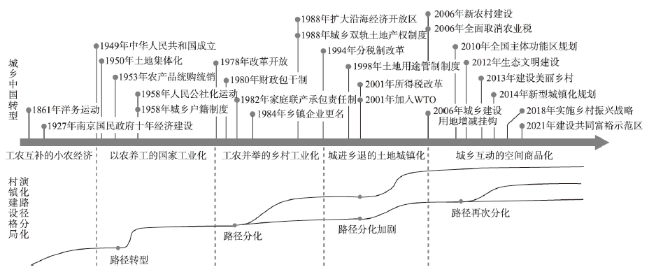
Town-village shows a heterogeneous development trend in the urban-rural transition in China. However, previous studies focused more on the dynamics of the physical space of town-villages and the impact of natural factors while ignoring the shaping effects of the underlying socioeconomic changes. Scientific understanding of town-villages development rules at the county scale and the refinement of typical evolutionary modes can help construct an efficient and coordinated town-villages construction pattern (TVCP) that adapts to socioeconomic patterns according to local conditions. It also helps to promote industrial reshaping, organisational reconstruction, and spatial reconfiguration of town-villages. More importantly, it can build a new platform for urban-rural integrated development and thus achieve common prosperity for both rural and urban areas. This research aims to refine the evolutionary modes of TVCP in counties with different development paths. First, we analysed the logic and history of the differentiation of the TVCP evolutionary path from the perspective of "social process-space form". Then, a multicase method was used to compare and analyse the differences in the evolution of TVCP in three typical counties of Jiangsu province from 2009 to 2018. Finally, we generalised the experience into universal evolution modes. The results show that the TVCP evolution is a typical process of the production of space, and the transformation of the production mode leads to various evolutionary paths of the TVCP. Moreover, there are obvious differences in the spatio-temporal characteristics of the TVCP evolution and the mechanisms of influencing factors under different development paths due to the difference in spatial demands of element agglomeration and evacuation. Based on the comparative case analysis, we summarise three types of evolutionary modes with different changing trends and dynamic mechanisms. The agricultural production mode shows a trend of polarised expansion of Chengguan town and shrewd contraction of the villages, which is mainly driven by urbanisation combined with state power and social demands. The industrial production mode, driven by rapid capital circulation dominated by market power, shows a trend of polycentric expansion of towns and consolidation of villages. The ecological consumption mode is characterised by the divergence between the revival and decline of villages; the driving mechanism is commodification and authoritativeness in rural space. According to the three modes, we suggest that efforts should be made to equalise basic public services, realise the citizenization of the migrant agricultural population, and promote commercial cooperation between urban and rural areas in the future.
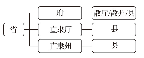
Administrative division is an important part of the national governance system. A systematic analysis of the spatial and temporal change pattern and influencing factors of the adjustment of county-level administrative divisions in the Qing Dynasty can better learn from and give play to the supporting role of administrative divisions in national and local governance. Using the textual research results of the national Qing history compilation project Qing History·Geographical Chronicles, and referring to the Qing Dynasty archives in China's first historical archives collection, Qingshilu, Qinghuidian, Daqingyitongzhi, local chronicles and other historical documents, this paper comprehensively analyzes the overall evolution and adjustment of county-level administrative divisions from 1683 to 1911. The research shows that: (1) There are 9 kinds of adjustment forms of county-level administrative divisions in the Qing Dynasty. The key of the adjustment is the proposal power of the governor, and the governor system is the institutional guarantee for the adjustment and promotion of administrative divisions. (2) The frequency of administrative division adjustment was greatly affected by the governance concept of the supreme ruler, showing fluctuating changes. The Yongzheng period was the absolute peak of administrative adjustment in the Qing Dynasty, the Guangxu and Xuantong periods was a relative peak, and the adjustment of Daoguang to Tongzhi periods was the least. (3) The setting of county-level administrative divisions was the most frequent, followed by the change and splitting of subordinate relations. Level change and consolidation were 2 types with lower adjustment frequency. (4) In the Qing Dynasty, the 4 types of adjustments of upgrading, relocation, abolishment and new establishment were widely distributed in 23 provinces, with the highest uniformity of provincial distribution, and the 4 types of adjustments of renaming, merging, changing affiliation and changing at the same level were concentrated in provinces such as Zhili, Henan and Shanxi. (5) The formation of the adjustment pattern of county-level administrative divisions in the Qing Dynasty was the result of the joint action of many factors. Political consideration was the decisive factor. All this reflected the management concept of clear hierarchy, clear rights and responsibilities, adjusting measures to local conditions and step by step.
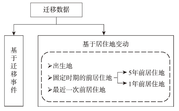
The two concepts of "liu dong ren kou (the floating population)" and "ren kou liu dong (the mobility of the floating population)", and relevant data based on these two concepts, have long been used extensively in China's relevant research and policy making, playing a dominant role in the fields. Different from the concepts of "migrant" and "migration" in the international literature, which are focused on people's spatial mobility, "liu dong ren kou" and "ren kou liu dong" are identified and measured by the separation of one's place of household registration (hukou) from the place of residence, and inconsistent with relevant international practices. By analysing various census data and data from China Migrant Dynamic Survey (CMDS), this article examines the validity and reliability of these two concepts and data based on them in the international context, and reveals that they have become increasingly invalid and not reliable in measuring migration events since the reform and opening up. The results further demonstrate that these two concepts and the data based on them have been increasingly detached from the real migration events and processes; they may become invalid because of overestimating the volume of the mobile population, or ineffective due to systematic omitting of certain group of the mobile population (such as urban-urban migrants), and can even seriously mislead people's judgment on the changing direction of migration flows. In addition, data on the floating population cannot be used to calculate migration rate and are not comparable in the international context. Based on the above analysis, the article argues that while the concepts of "liu dong ren kou" and "ren kou liu dong" and relevant data based on these two concepts still need to be used for a long period of time due to the continuing existence of the hukou system and its roles in the provision of public services, social welfare and social security, relevant concepts, measurements and ways of data collection in China's migration research should be gradually shifted to and focused on the nature of migration as spatial events; transition data based on the usual residence five years and one year ago should be gradually used as the main data sources and included in the short form of future censuses, and migration event data based on population registration and administrative records should be more fully used, so that China's migration research can be conducted on the solid basis of valid and reliable data sources.
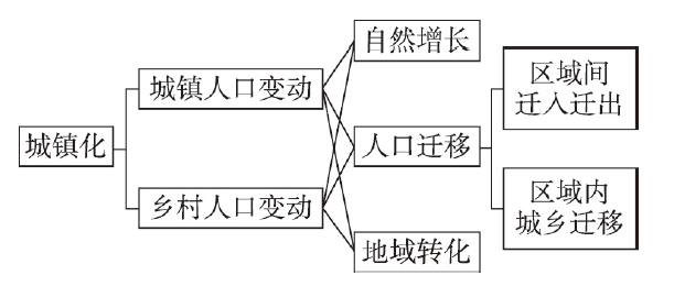
Urbanization is the outcome of population dynamics in both urban and rural areas, which has a profound influence on urban-rural development. This paper puts forward a method to identify regional types of urbanization from the perspective of urban-rural population change. Using this method and based on the census data, this paper analyzes the spatial pattern and influencing factors of China's urbanization. The results show that China has entered an era of rapid urbanization since 1990. Urbanization rates have risen in almost all regions, but with varied pathways over time and across regions. With the decline of natural population growth and the expansion of rural-urban migration, the process of urbanization depends more and more on rural population loss, leading to the transformation of urbanization regional type from "urban-rural growth" to "urban growth" in the country. Although the "urban growth" is the most common regional type of urbanization at both provincial and prefecture levels, the transformation of urbanization regional type from "urban growth" to "rural loss" has been witnessed in a large number of regions in the past decade. Besides, regions with the "urban-rural growth" type have shrunk to places such as Tibet and Shanghai while regions with the "urban-rural loss" type have expanded in non-provincial capital cities in Northeast China. At present, China's urbanization regional type is still driven by economic development: rural population declines faster in areas with rapid economic growth, leading to the "rural loss" urbanization; rapidly industrialized regions have undergone faster urban population growth and slower rural population loss than their counterparts; while the effect of social factors such as public services on urbanization regional type is limited. In addition, the impact of new urbanization strategy and rural revitalization strategy is not yet clear, given the limited attractiveness of urban agglomerations of the western region as well as small and medium-sized cities and the prevalence of rural population loss.
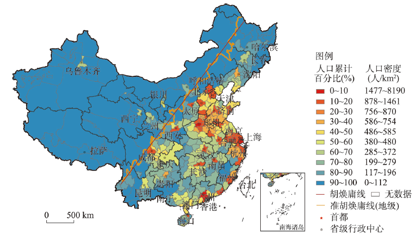
The "Hu Line" is a geographical line connecting Heihe City and Tengchong City in China. It is densely populated on the southeast side of the "Hu Line" but sparsely populated on the northwest side. Since the implementation of New-type Urbanization strategy in 2014, the spatial pattern of population distribution on both sides of the "Hu Line" has changed a lot. We put forward the "Quasi-Hu Line" based on the boundaries of prefecture-level administrative divisions. According to the seventh population census data in 2020, this study focuses on the new characteristics of population spatial patterns and population growth patterns on both sides of the "Quasi Hu Line" from 2010 to 2020. We analyze the driving factors combined with the development of New-type Urbanization. The main conclusions are as follows: (1) The human-land relationship reflected by the "Hu Line" was still stable, and the overall distributions of densely populated and sparsely populated areas were also steady. In 2020, the population ratio of the southeast side to the northwest side was 93.5∶6.5. (2) The population share of the northwest side still increased slightly, but the increment was significantly lower than that before 2010. (3) The centralization index of the population on the northwest side turned from decline to increase after 2010, which indicated the concentration of spatial population distribution in the northwest half was similar to that in the southeast half. (4) The spatial differentiation of population growth on the southeast side has been strengthened. The negative population growth area accounted for 54.22% of the southeast side from 2010 to 2020, exceeding the positive population growth area. The population growth on the northwest side had also changed from the "relative balance" model to the "Matthew effect" model, with the negative population growth area accounting for 26.14% of the northwest side. (5) The relative population growth advantage of provincial capitals was becoming much more prominent. The spatial polarization process of population growth slowing down or negative growth was formed in the surrounding areas of provincial capitals. In addition, such a process on the northwest side was more significant than on the southeast side. (6) The driving factors, including the level of economic development, the scale of urban population size, and the level of administrative divisions, significantly impacted population growth. For the northwest side, the level of administrative divisions had a particularly significant impact on population growth, while the impact of urban agglomerations was not noticeable. In general, the northwest side had begun to present similar population spatial distribution patterns and driving factors with the southeast side. In the context of population migration and urbanization, the novel patterns of spatial population distribution reflected a kind of "breakthrough" of the "Hu Line". With China's total population turning to decline and urbanization entering the mid-late stages, more attention should be paid to the regional differences and coordination of demographical structures on both sides of the "Hu Line".
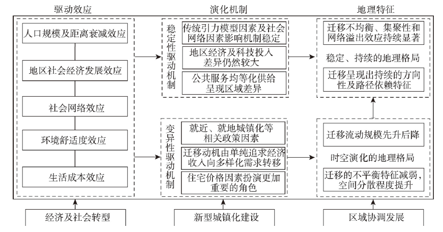
Understanding the geographical pattern and driving factors of China's population migration in the first 20 years of the 21st century has become a pivotal issue in promoting the construction of the new-type urbanization and interaction development between regions during the 14th Five-Year Plan period (2021-2025). Supported by the data of the sixth and seventh national population censuses and 2005 and 2015 national 1% population sample surveys, this paper aims to investigate the spatiotemporal evolution characteristics and influencing factors of interprovincial migration in China from 2000 to 2020. Relevant population geospatial analysis and the eigenvector spatial filtering Poisson pseudo-maximum likelihood estimation (ESF PPML) gravity model are employed. The following conclusions are drawn: (1) China's population migration patterns were generally stable from 2000 to 2020, where notable imbalance and network spillover effects were also detected. A large number of migrants from central, western and northeast parts of China tended to move to the eastern region. (2) The overall migration patterns between 2000 and 2020 revealed several changing characteristics. The degree of imbalance and spatial agglomeration of migration patterns gradually weakened. Yet, a north-south differentiation emerged. It is also found that the out-migration trend of the northeast region increased with the elaspe of time. (3) The ESF PPML model indicated that gravity factors (population scale, geographical distance), regional socio-economic factors (wage disparity, proportion of investment in science and technology and education, medical care), social network factors, environmental comfort (PM2.5 concentration) and living costs (proportion of housing price) drove the interprovincial migration pattern between 2000 and 2020. (4) The influence of regional economic differences on interprovincial migration reflected a weakening trend. The pattern of population migration gradually turned into the decision-making of diversified demands for the economy, public services and urban amenities, while the living cost factor represented by housing price had played a gradually significant part. The conclusion of this paper provides policy references for the construction of the new-type urbanization and coordinated development between regions during the 14th Five-Year Plan period in China.
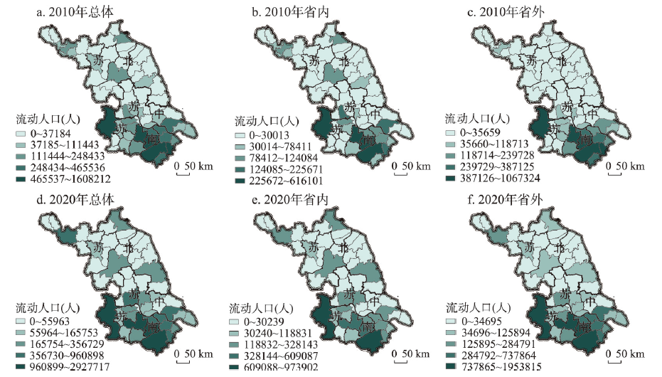
Based on the data of the sixth and seventh national censuses (Jiangsu province), this paper seeks to explore the spatiotemporal differentiation and influencing mechanism of the distribution of floating population in cities (districts), towns, and rural areas from 2010 to 2020. The findings show that: (1) The floating-permanent population ratio in cities and towns in Jiangsu generally increased from 2010 to 2020, but the rate of increase in towns was significantly higher than that in cities; the floating-permanent population ratio decreased in nearly half of the units in rural areas. (2) The gradient pattern (south Jiangsu - central Jiangsu - north Jiangsu) of the distribution of the floating population remained stable. South Jiangsu is still a highland for attracting the floating population, but towns in central and north Jiangsu have become attractive to the floating population in the province. There are also differences in the distribution of the intra- and inter-floating population in cities, towns, and rural areas. (3) The share of the floating population in parts of rural areas in south Jiangsu and some towns in central and north Jiangsu increased significantly, reflecting the agglomeration capacity of the towns and rural areas for the floating population. (4) The results of the models show that the increase in government social investments is important to enhancing the attractiveness of cities, towns, and rural areas to the floating population; the Engel coefficient of urban residents has different effects on intra- and inter-floating population in cities and towns; the impacts of industry in cities, towns and rural areas are positive; the upgrading of the economic structure only has a positive effect on the ratio of intra-floating population in cities and towns; the effect of the farming industry is negative in rural areas.
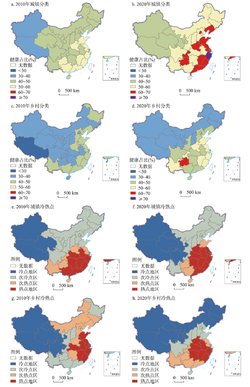
As the speed of population ageing increases in China, understanding the spatial pattern evolution of the older adults' health level is of great significance to the implementation of the healthy aging strategy. Based on the self-rated health data of the older adults from the sixth and seventh national censuses, this paper tried to depict the dynamic evolution of the older adults' health level in urban and rural areas across different provincial-level regions in China from 2010 to 2020 by using exploratory spatial data analysis method. Then this paper built Gravity-GTWR models to explore the temporal and spatial variations in the factors influencing the older adults' health, such as socioeconomic development, population migration, environmental pollution and protection. The main findings were as follows: (1) From 2010 to 2020, the health level of China's older adults increased overall, but the gap between urban and rural areas further expanded. In terms of the health level of the urban older adults, the pattern of "decreasing along east-middle-west" tended to be strengthened. As for the health level of the rural older adults, the spatial pattern has transferred from "decreasing along east-middle-west" to "high in the south and low in the north". (2) Although the role of socioeconomic development was weakened, it was still the primary factor that shaped and altered the spatial pattern. The rural-urban population migration widened the urban-rural gap in the health of older adults. (3) The role of natural environmental background tended to be weakened, while the role of environmental pollution was enhanced. The strengthened environmental protection measures started to exert positive effects on the health level of older adults in urban areas.
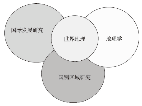
International Development Studies refers to the study of the localization process of development experience and knowledge of relatively developed countries in developing countries, and is a classic topic of Western geographic research. This paper reviews and summarizes the disciplinary development of International Development Studies since the mid-20th century, including the background and process of its emergence, and its current disciplinary pattern. It also systematically discusses four phases of evolution in international development knowledge, including the modernization theory phase (1950s-1970s), the neoliberal phase (1980s-1990s), the neo-structural phase (2000s), and the new modernization theory phase (2010s-present). Drawing on the Western experience and considering the current rise of China, we suggest that China has reached a new stage when it needs to provide international development knowledge to developing countries and should actively promote the study of International Development Geography. In relation to the requirement of constructing the Belt and Road Initiative towards a new stage of high-quality development, and based on the disciplinary advantages of geographic research, we propose four directions of future research in International Development Geography, including China's regional development experience and spatial governance model, the modernization geography of developing countries, case studies of major overseas projects of the Belt and Road construction, and the geography of international development financing.
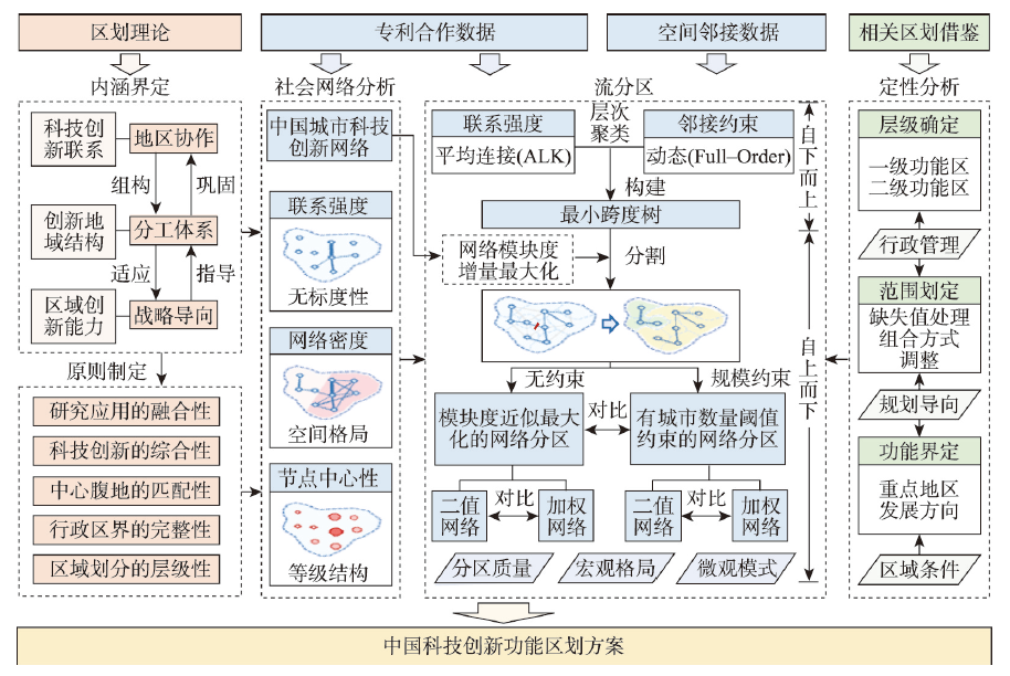
Carrying out the functional regionalization of scientific and technological innovation in China is a basic work to grasp the overall configuration and guide the improvement of China's scientific and technological innovation capabilities. However, there are still large gaps in related research. Under the background of China's innovation-driven development strategy, the planning and construction of regional scientific and technological centers is considered an important task at present, which makes the functional regionalization of scientific and technological innovation in China urgently needed due to its guiding significance. From the perspective of intercity innovation cooperation network, combined with the existing geographical regionalization theories and innovation geography research, this paper devices a functional regionalization method for scientific and technological innovation in China by applying the dynamically contiguity-constrained hierarchical agglomerative clustering and the graph partitioning technology based on modularity. With the intercity patent cooperation data of 357 cities in China from 2017 to 2019 and their spatial contiguity data as an input, the topological relationship in the network space and the positional relationship in geographical space are combined to form regions covering continuous earth's surface which are tightly knit inside and show prominent regional characteristics in the scientific and technological innovation field. Based on the topological structure analysis of the urban network and the comparison between the regionalization results of the binary network and the weighted network, a regionalization scheme containing 4 first-level functional regions and 20 second-level functional regions is formulated. According to the regionalization, China is divided into four functional plates of scientific and technological innovation: north, south, east and west, each of which contains 4 to 6 secondary functional regions. The delimitation of scientific and technological innovation according to the regionalization results is highly consistent with the administrative divisions on the provincial level, providing reference for government to plan the overall management of scientific and technological innovation on macroscale. It is suggested that in the future, relying on the construction of the functional regions and the leadership of the regional central cities, all regions should formulate regional innovation and development strategies according to local conditions, and actively contribute to the implementation of the national innovation-driven development strategy.
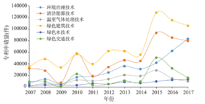
Green technology innovation is the first driving force to promote green development and harmonious coexistence between human and nature. Green technology innovation is the core issue of environmental economics, innovation economics, innovation management and other research fields. It is also one of the emerging topics in the field of environmental economic geography in recent years. Overall, the research on enterprise level is dominant, while the research on spatial scale is relatively less. In this paper, by deriving green patent applications for measuring green technology innovation from the Wanfang Patent Database, the spatial and temporal characteristics and its determinants of green technology innovation in China's city system from 2007 to 2017 are explored. The results indicate that technologies related to buildings has dominated the development of environmental innovation in China's city system, while technologies in the field of greenhouse gases and water adaptation were quite unpopular throughout China. In 2007, China's environmental innovation was dominated by individuals and enterprises. By 2017, enterprises have become the main body of China's environmental innovation, highlighting the essential characteristics of enterprises as the subject of environmental innovation. In space, the geography of environmental innovation in China's city system presents a strong spatial imbalance feature, a tripolar pattern dominated by the Yangtze River Delta, the Pearl River Delta, and the Beijing-Tianjin region has become increasingly prominent. In terms of determinants, spatial Durbin model regression results reflect that there are significant spatial spillover effects and path dependence characteristics in China's environmental innovation. Environmental regulation intensity, city size, market size, technological innovation level, FDI, and air quality have obvious positive effects on urban environmental innovation, while the industrial structure dominated by secondary industry has obvious inhibitory effect on urban environmental innovation.
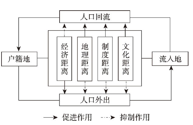
Decades of urbanization and economic growth in central, western and coastal regions of China have transformed the increasing flow of return migration across places, which exerted a profound impact on regional development prospects. Thus, elaborating the return motivation of internal migrants is of great theoretical and practical significance. From the perspective of "distance" in geography, this paper introduces two additional non-economic dimensions of distance, namely, cultural and administrative distances, between places of destination and origin into the study on migrants' return-to-hometown intention, and focuses on the effects from cultural, administrative and economic borders on return intention. Our measurement combines dialect, geographical and socio-economic datasets with a theoretical framework of multidimensional distances that influence return migration intention. We conduct an empirical analysis using data from the 2017 China Migrants Dynamic Survey and the method of logistic regression modeling. The results show that multidimensional distances between places of destination and origin exert a significant impact on the return intention of migrants, which is consistent with the theoretical predictions. Economic distance restrains return migration intention, while geographic, administrative, and cultural distances promote the intention of migrants to return. This finding remains robust after accounting for possible measurement errors in explanatory variables. The estimated effects of multidimensional distances on return intention vary with the characteristics of individual migrants and destination cities. In terms of individual heterogeneity, the negative effect of economic distance on return migration intention increases, whereas the positive influence of geographic distance gradually decreases with increases in the age and level of education of migrants. In terms of urban heterogeneity, the promoting effect of administrative distance on return intention tends to decrease, and the improvement of urban economic level decreases the positive effect of geographic distance on return intention with the increase of urban population size. This study strengthens the understanding of the phenomenon of return migration under "human-environment" interactions, and helps to enrich the study of migration in geography.
Intangible cultural heritage (ICH) is a vivid testimony to the continuous inheritance of Chinese civilization. The study of ICH from the perspective of the geographical environment, spatial relationships and diachronic development is of great significance for understanding objectively the reasons for the formation of spatial distribution patterns of ICH and the pathways and extent of its spread; as a consequence, such information can help us improve our understanding of the integrity and historical continuity of Chinese culture. From a geography perspective, this study seeks to explore the spatial patterns of ICH based on knowledge concerning the extent of spreading of ICH. At the same time, the evolution tree model is used to express the spatiotemporal development of ICH in a simple, clear and visual way. Also, the factors influencing the spatial distribution of ICH are analyzed. The main findings are as follows: (1) The national intangible cultural heritage is concentrated mainly in areas with a high level of development, prominent national characteristics, profound cultural accumulation, and excellent natural conditions. The North China Plain and the middle and lower reaches of the Yangtze River Plain constitute the main focal centers for ICH. (2) A high internal consistency is found in Beijing and Tibet, and Jiangsu and Zhejiang exhibit the characteristics of large dispersion and small aggregation. (3) The distribution centers for ICH in China generally present as pathways running from west to east and north to south. (4) Changes in the ecological environment, population migration, changes in the patterns of economic development and the chaos brought about by war are the key factors which have influenced the spread of ICH. Appreciation of the aforementioned features allows us to gain consensus on the development and evolution of ICH, and hence can justify how we allocate funds to promote ICH projects, paying particular attention to researching the historical context, and preserving the extraction of the local characteristics of ICH.

Clarifying the spatial distribution of middle and higher vocational education resources and their influencing factors is an important proposition for improving China's vocational education system and promoting the balanced development of regional vocational education. This study attempts to fill in the knowledge gap that the spatial distribution characteristics and influencing factors of vocational education resources at the county level is underexamined. We firstly generate a matched data set of multiple factors at the county level, including population, economy, middle and higher vocational education resources at China's county-level scale. Secondly, we analyze the spatial distribution characteristics of middle and higher vocational education resources in nearly two decades and then identify the quantitative relations with socio-economic development indicators. Thirdly, we examine the spatial equilibrium of vocational schools and the allocation of vocational education resources by industries. Finally, we put forward the corresponding policy options for China's vocational education resources allocation. The result show that the middle and higher vocational education resources at different spatial scales concentrate to the east of the Huhuanyong Line and scatter to the west of the line. In terms of the influencing factors, the number of people under the age of 15 has a significant positive role in promoting the number of middle vocational schools, and the numbers of secondary and tertiary industries has a positive impact on the number of higher vocational schools. The research results also present that the middle vocational education resources are widely distributed, and relatively unbalanced in the west. On the contrary, the higher vocational education resources are relatively unbalanced in the east, and the difference in higher vocational education resources is dominated by variations within cities. Accordingly, we suggest that the allocation of higher and middle vocational education resources should be optimized according to local and surrounding economic development, industry and labor demand. Specifically, the eastern region requires a more reasonable allocation of higher vocational education resources, and the western region should strengthen the construction of middle vocational education resources. Moreover, the connection and coordination of middle vocational education resources between the east and the west should be emphasized as well. In addition, by relying on the cities with premium higher vocational educational resources, the development of middle vocational schools in their surrounding counties can be promoted, especially for the schools setting up the related majors. These policy options put forward by this research can shed light on enhancing the social recognition of vocational schools, and eventually boost rural revitalization and new urbanization development in China.

The central region, located in China's inland hinterland, connects the east with the west and the south with the north, and plays a very important pivotal role in the national economic development. Significant progress has been made in the rise of the central region, but unbalanced and inadequate internal development remains a serious problem. How to promote the high-quality rise of the central region in the new era and build a new pattern of regional coordinated development is a realistic problem that needs to be solved urgently in China. The Central Region Coordinated Development Forum of the 24th Annual Session of the Chinese Association for Science and Technology discussed this topic. The main points are: Coordinated regional development is the strategic orientation of the country in the new era, the spatial planning and industrial layout should respect the laws of nature and economy, and the layout of national strategic planning should be transformed from "differentiation" to "differentiation+ systematization" in the main functional areas. The central region should take the urbanization pattern of "two horizontal and three vertical lines" as the framework and actively integrate into the major national and regional strategies; give full play to the role of urban agglomerations in supporting the central region, promote the coordinated development of urban agglomeration in the middle reaches of the Yangtze River, and strengthen the core supporting role of Wuhan metropolitan circle, Changsha-Zhuzhou-Xiangtan metropolitan circle, and Nanchang metropolitan circle; give full play to our comparative advantages and promote the high-quality development of industries with traditional advantages such as agriculture, energy, electric power, construction machinery and equipment manufacturing; pay attention to ecological and environmental protection, and strengthen water safety management in urban clusters along the middle reaches of the Yangtze River; strengthen weak links in agriculture, promote rural vitalization, and create a new situation in which urban and rural development is coordinated and integrated.