The author describes his understanding of current academic atmosphere and innovative culture in the field of geographical sciences based on his observation from five perspectives. The key points can be illustrated as follows: (1) According to geographical methodology, the theories, concepts, judgments of geography are based on observation, analysis and conclusion regarding the spatial characteristics and variation of a substance that objectively exists on the earth surface. (2) In light of issues concerning specific cases, this paper highlights the importance of "be well-grounded and speak up moderately" to the knowledge accumulation and application of the researchers. (3) The study comes up with some comments on "what is scientific innovation" and "how to achieve scientific innovation". (4) In the academic practice, we should correctly handle the relationship between individuals and their research teams. (5) Science research should adopt and support the consulting to the government departments concerned.
In the past four decades, due to different research contents and spatial governance priorities, the names and scopes of regions such as Beijing-Tianjin-Hebei, Beijing-Tianjin-Tangshan, Bohai Rim and Greater Bohai Sea have changed many times. As the earliest humanities and economic geography research in China, its object area has attracted more and more attention such as disciplines of economic trade, ecological environment, and urban and rural planning. Based on the academic papers, monographs, and influential scientific research projects, this article reviews the research progress of the Beijing-Tianjin-Hebei region in the past 40 years. The progress has experienced a change process of "Beijing-Tianjin-Tangshan - Bohai Rim region - Beijing-Tianjin-Hebei". There are four recognizable phases in the research development to date. In the 1980s, economic geography mainly focused on land planning in the Beijing-Tianjin-Tangshan region, which was relatively limited in scale. In the 1990s, the research area was expanded to the Bohai Rim region, and the intersection of economic and trade science and geography was carried out in the process of economic integration in the eastern (northern) sub-regions. In the first decade of the 21st century, the research field turned to the integration of the Beijing-Tianjin-Hebei region, ecological environment science and urban planning science with large-scale intervention. In the 2010s, we started multidisciplinary regional comprehensive research on the coordinated development of the Beijing-Tianjin-Hebei region. During this period, the Chinese government carried out a series of major plans in the region, including the Beijing-Tianjin-Tangshan Land Planning in the 1980s, the Bohai Rim Economic Cooperation Zone in the 1990s, the Beijing-Tianjin-Hebei Metropolitan Region in the 2000s, and the Guidelines for the Coordinated Development of Beijing-Tianjin-Hebei Region in the 2010s. These major plans have formed a benign interactive relationship with regional research. This interactive relationship not only significantly enhances the scientific nature of regional planning and strategic decision-making, but also effectively promotes the development of humanities and economic geography, and it has also enhanced the research on the evolutionary laws of regional complex systems under the strong interaction between human and nature.
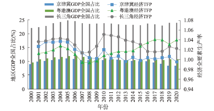
How to raise innovation efficiency to promote the economic development from relative decline to prosperity and then drive the development of the northern hinterland becomes a prominent problem facing the in-depth acceleration of the coordinated development of the Beijing-Tianjin-Hebei (BTH) region in the new development stage. This paper points out that the inefficiency of innovation is the key to economic stagnation in the BTH region, and empirically demonstrates that the relative inefficiency of innovation geography in the region is the main reason that restricts the innovative efficiency development based on the "Density, Distance, Division, Differentiation" (4D) framework. The strategic proposition of reshaping innovation geography in the BTH region is put forward. First of all, the article analyzes the disparities in the evolution trends of economic efficiency, innovation competitiveness and innovation efficiency in the BTH region, the Yangtze River Delta, the Guangdong-Hong Kong-Macao region, and finds that the economic efficiency in the BTH region is lack of competitiveness and tends to decline, characterized by weak innovative advantage and low innovation efficiency. Secondly, based on the 4D framework, there are several reasons for the relative inefficiency of innovation from a perspective of economic geography. These reasons include the coexistence of low density of economy, population and patent with high concentration imbalance, the wide scope of patent transfer and the low localization level of industry-university-research collaboration, and the severe innovation segmentation with strong spatial heterogeneity, and relatively weak heterogeneous advantage. Finally, the measurement results show that the relative change of 4D factors will significantly affect the fluctuation of innovation relative efficiency, which indicates that the relative inefficiency of innovation geography in the BTH region is the root of innovation relative inefficiency. This paper shows that the reconstruction of innovation economic geography based on 4D framework is vital to improve innovation efficiency and realize innovation-driven development in the BTH region.
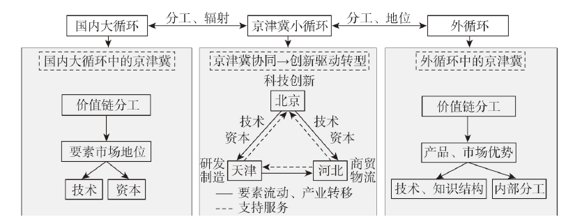
The Beijing-Tianjin-Hebei (BTH) region has experienced a path from competition and cooperation to high-quality coordinated development. Under the new development pattern of "dual circulation", the coordinated development of the BTH region is facing new challenges and new development goals, and it is urgent for the region to achieve innovation-driven economic transformation. This paper starts from the aspects of division in the value chain, technology and capital element flow, systematically combs the status in value chain and radiation capabilities of the BTH region in the "international circulation" and "national circulation", and coordinated development status of the BTH region expressed by "internal circulation". It was found that the BTH did not form the capacity corresponding to the world-class urban agglomeration in the "international circulation", and occupies the low value-added link of the value chain. In the "national circulation", the BTH has played a role of R&D service center, so it occupies the high value-added link of the value chain. It also exports technology and capital and becomes a highland of domestic innovation and capital, but its attraction and radiation are limited. Further exploration found that the BTH is relatively marginalized in the "international circulation", which is one of the important reasons that they have not been complementary to each other in "internal circulation". Moreover, Tianjin and Hebei are less attractive to Beijing's capital and technology, so Beijing's patents are difficult to transform within the BTH urban agglomeration. Therefore, the BTH region failed to achieve innovation-driven economic growth. In the next stage, the BTH urban agglomeration should be driven by the horizontal knowledge chain and gradient innovation chain to build a vertical industrial chain. Specifically, in the "national circulation", efforts should be made to create a collaborative pattern, that is, Beijing specializes in research and develop, Tianjin specializes in high-end manufacturing, and Hebei specializes in logistics service. "International circulation" builds a model of "Beijing innovation cluster, Hebei integrated manufacturing, Tianjin R&D and shipping" mode, gradually realize the "national circulation" to feed back the "international circulation".
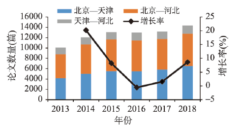
Building a hierarchical and reasonable structured science and technology cooperation network plays a very important role in promoting collaborative innovation in Beijing-Tianjin-Hebei region (BTH). This paper analyzes the evolutionary characteristics of the science and technology cooperation network between cities in the BTH during 2013-2018 from two perspectives: the research cooperation network based on knowledge innovation and the technology cooperation network based on technology innovation. This paper uses micro data of collaborative papers and collaborative patents and applies social network analysis to examine the evolutionary characteristics of the science and technology cooperation network between cities in the BTH from 2013-2018, and empirically tests the influence of 78 pairs of city in the study area on the science and technology cooperation based on panel econometric model factors. The main conclusions can be drawn as follows. First of all, the rapid growth of the research cooperation network of the BTH presents a spatial structure characterized as the twin cores of Beijing and Tianjin, with Beijing-Tianjin as the main axis and Beijing-Baoding-Shijiazhuang as the secondary axis. Second, the BTH gradually formed a technical cooperation network structure with Beijing as the main center, Tianjin and Shijiazhuang as secondary centers, Langfang, Baoding and Cangzhou as tertiary hubs, and other cities as nodes. Finally, small distance plays a positive role in science and technology cooperation between cities, and the compression of spatial and temporal distance brought by the operation of high-speed rail can weaken the spatial attenuation coefficient of science and technology cooperation. Compared with research cooperation, technical cooperation is more sensitive to spatial distance. Technological proximity is the main driving factor for promoting science and technology cooperation between cities, especially the promoting effect on technological cooperation is more obvious. The smaller the gap of economic development, the easier it is to generate science and technology cooperation cooperation between cities.
The coordinated development of the Beijing-Tianjin-Hebei (BTH) region and the implementation of the policy of relieving non-capital functions from Beijing are one of hot topics in current academia and the government. The distribution and interaction patterns of urban functions are an important aspect to depict the performance of the coordinated development and governance strategies of the BTH urban agglomeration. Based on the interaction principle of urban functional zones in the BTH region, we introduced the shift-share analysis model, revised land ecological niche model, and coupled a new interactive model by expanding the gravity model for urban functional interaction patterns, supported by GIS technique. We consider the POI as a commonly used big data to analyze urban problems and characteristics, this study takes the BTH urban agglomeration as the study area and uses three periods (2010, 2016, 2019) of POI datasets to identify urban functional zones. Then we apply the new interactive model to reveal the characteristics of the functional interaction patterns from space and time dimensions. Meanwhile, we analyze and evaluate the coordinated development and implementation of the policy of relieving non-capital functions from Beijing, and come up with some suggestions. Our findings are: (1) the total area of urban functional areas increased 1.5 times over the past decade, and the mixed functional areas are the fastest-growing urban functional zone (1.7 times). (2) The industrial and commercial functional zones of Beijing had been dispersing steadily, but the residential, scientific, educational and cultural, and public service functional zones were still aggregated. (3) Langfang, Tangshan, Tianjin, and Baoding, which are located in the center of BTH region, act as "middlemen" in the redistribution process of the relieving policy. They become main cities to drive functional interaction. (4) Shijiazhuang mainly received the functional zones from Tianjin and Langfang, which shows the relay characteristics. (5) The government's decision-making for redistribution of urban functional zones in the BTH region should consider the evolution trend of functional interaction patterns among cities so as to take targeted governance measures. Our findings indicate that the urban functional interactive model could better explain and reveal changing characteristics of the functional interaction patterns in the study region.
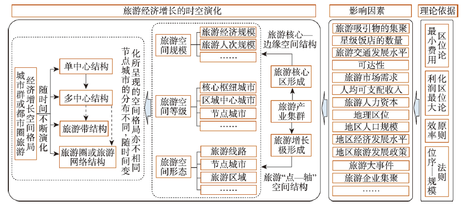
Revealing the spatiotemporal evolution of regional tourism economic growth and exploring its influencing factors will help enrich the theoretical and practical research on regional tourism economic development and formulate relevant policies. In terms of methodology, this study is based on the constructed research framework and multivariate analysis model of the spatiotemporal evolution of tourism economic growth in the Beijing-Tianjin-Hebei region, and employs the methods including Gini coefficient, kernel density estimation, and bivariate local autocorrelation. The spatial pattern and its evolution process of tourism economic growth in the study region from 2001 to 2019 are investigated from the scale, level and pattern changes of the tourism space. The influencing factors are deeply analyzed based on the panel multiple regression model and spatial econometric model. The results show that: (1) The spatial pattern of tourism economic growth gradually shifted from dual cores to multi-cores. Regional tourism central cities and some peripheral tourism node cities became the main areas of tourism economic growth. (2) The spatiotemporal evolution process of tourism economic growth can be divided into three stages, namely, the dual core polarization alleviation stage under high-speed growth, the transition stage from dual cores to multi-cores under medium speed growth, and the multi-core formation stage under fast-speed growth. (3) The main factors affecting the tourism economic growth are per capita GDP, the number of star grade hotels, the length of expressway to Beijing or Tianjin, tourism development policies, and tourism events. Among them, the per capita GDP had a significant spatial spillover effect on the growth of tourism economy in this region. (4) There are some differences in tourism economic growth factors among core hub cities, regional tourism central cities and node cities. The number of star grade hotels, tourism events and PM2.5 concentration have great influence on tourism economic growth of core hub cities and regional tourism central cities, while the urban road area, the length of expressway to Beijing or Tianjin, tourism development policies, tourism events, the number of taxis and PM2.5 concentration are the main influencing factors on the tourism economic growth in tourism node cities.
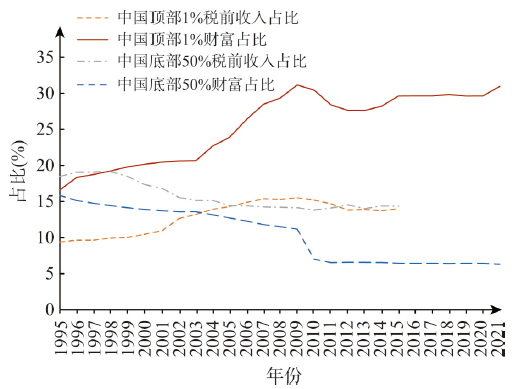
"Common prosperity" has become a matter of concern in China's society. The outline of China's long-term goals for 2035 calls for substantial progress in common prosperity. Therefore, measuring income and net wealth inequality, and identifying the differences and causes in regional common prosperity are of great significance in China. Based on the data of Chinese Household Financial Survey (CHFS) from 2011 to 2019, this paper uses Gini coefficient, Lorentz curve and panel data econometric model to analyze the evolution patterns and causes of regional income and net wealth inequality, and find out differences in the way of promoting common prosperity among regions. The results are shown as follows: (1) Although the national income inequality considerably declined from 2011 to 2019 but net wealth inequality remained large. There are obvious spatial differences in the changes of income and net wealth inequality, and the cumulative shares of each income or wealth quantile from 2011 to 2019 show different changing trends. (2) There is an approximate inverted "U" relationship between economic development and income inequality in provincial-level regions (hereafter province) of China, and an approximate inverted "N" relationship between economic development and net wealth inequality. (3) The processes of common prosperity are different among different regions. Specifically, there has been a general increase in households net wealth in developed provinces and these provinces have been promoting common prosperity, but the trend is not obvious in developing provinces. This study provides a reference for the formulation of policy on common prosperity of the central and local governments. In order to promote common prosperity in China, governments at all levels should provide assistance to vulnerable groups, scientifically and rationally make use of and manage natural resources, increase investment in transportation infrastructure construction, encourage capital investment to promote capital accumulation, and increase public finance expenditure on scientific and technological innovation.
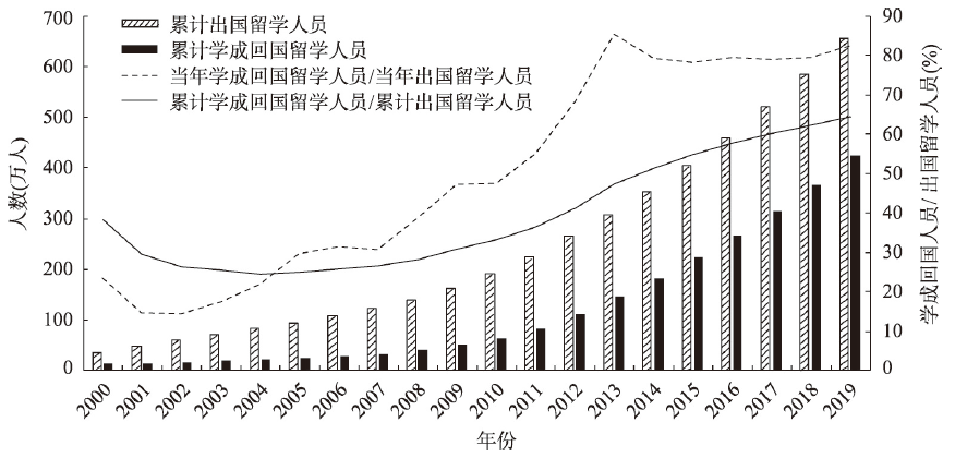
In the current era of the knowledge economy, geography and international migration studies are paying close attention to intellectual migrants and their decisions. However, there is little geographical exploration of these returnees in the literature. Taking Chinese academic returnees in Guangzhou as a case study, we apply qualitative research methods, in-depth interviews and observations to explore the dynamic process of their return and local embeddedness in their home country from multidimensional perspectives. The findings indicate that: (1) The main streams of the inflow of Chinese academic returnees relate to job opportunities and the comparative advantages of the transnational capital, family relations and cultural belonging. (2) After their returns, they have to face the problem of how to re-embed into work, personal life and social networks, and so on. The process and result of re-embeddedness is influenced by institutional structural factors such as work and work environments, and non-institutional factors such as daily practices. (3) Academic returnees have a relatively strong sense of subjective agency during the process of their local embeddedness due to their relatively high cross-border intellectual capital and social networks. Against the background of transnational mobility, the identification of academic returnees manifests as the character of trans-local subjectivity, and their construction of 'home' changes over time and varies by scale. We assert that a multi-place social embeddedness through trans-local social networks endows academic returnees with a sense of belonging that does not necessarily attach to geographical space with a fixed physical boundary. To some extent, this indicates the downplay of 'place' as defined by geographical location. The implication is that we may focus more on social networks and everyday life practices of academic returnees in order to better understand the returnees' behaviors. A detailed exploration of the process and results of academic returnees' local embeddedness from the microscopic and subjective perspectives can further help us understand and enrich the migration theory and research framework during the period of transition, and also provide guidance and suggestions for China's talent policy and development strategy.
This paper aims to reveal the net effect and its dynamic changes of the Internet on intra-urban employment distribution. Firstly, we incorporate the relative changes of the Internet's dispersion and agglomeration force into the analytical framework of the dynamic impact of the Internet on intra-urban employment distribution, and propose corresponding theoretical hypothesis. Secondly, we use the micro-data of 22.47 million enterprises in 289 prefecture-level cities in China's Economic Census in 2004, 2008 and 2013, and take postal districts as the basic spatial unit to construct the employment agglomeration index. To alleviate endogeneity, we construct instrumental variables with the "8-horizontal and 8-longitudinal" optical cable trunk network and the functional form of the exogenous logistic curve, and re-estimate the results. The results show that, on average, the Internet can significantly promote intra-urban employment agglomeration, but with the increase of Internet penetration rate, its promotion effect is characterized as "marginal diminishing", while the spatial multi-centricity of urban employment continues to increase. For cities with a high economic development level, the increase in Internet penetration rate promotes temporary dispersion of intra-urban employment and then "marginal increasing" agglomeration. Thus, this paper concludes that along with the continuous penetration of the Internet and the development of cities, the increase of the agglomeration force of the Internet will exceed the increase of the dispersion force, thereby reinforcing the city's strengths as a center of production and exchange to be a facilitator of urban employment agglomeration, while driving the evolution of urban employment towards a polycentric structure. This paper contributes to the existing literature by revealing, for the first time, the changing characteristics of the Internet's impact on the spatial structure of urban employment with the continuous penetration of the Internet, as well as the heterogeneity of its manifestations in cities at different levels of development, and offers a new explanation for the inability of existing studies to reach consistent conclusions on the diversified impact of the Internet with a rigorous analytical paradigm and a dynamic perspective. The findings of this paper are of great significance for predicting the spatial distribution of economic activities in future cities and guiding spatial planning.

Drug dealing is closely related with economic benefits, which brings great damage to the society. Many strict measures have been taken to crack down drug-related crimes in China, but there is a lack of research on the spatial displacement and influencing factors' changes of drug dealing after crackdown. Based on the routine activity theory, crime pattern theory and social disorganization theory, this study built negative binomial regression models before and after the "Thunder Anti-drug" operation respectively, and analyzed how the impacts of semi-public, outdoor and private spaces on drug dealing had changed in the microcosmic scale. The findings are as follows: (1) Drug dealing crimes dropped significantly immediately after the operation. (2) The impact of the semi-public space, such as hotels, stores, supermarkets and entertainment places, on drug dealing crimes decreased after the crackdown. (3) The impact of outdoor public space, such as main roads, branch lines, bus-stops and parks, on drug dealing crime strengthened after the intensified crackdown. Private space such as residential areas had significant positive influence on drug dealing crimes, and the impact strengthened after the crackdown. The results show that drug dealing crimes moved to outdoor public space and private space from semi-public space. The "Thunder Anti-drug" operation was effective to crackdown top drug traffickers and drug dealing gangs, which led to a massive decline in drug dealing crimes in 2014. The follow-up operations further improved the ability for investigating hidden drug crimes. The results show that law enforcement department must carry out sustained and targeted operations on drug related crimes, to ensure continuous effect.
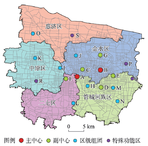
It is of great significance to identify and analyze the spatial form of urban polycentric structures for the optimization of urban spatial structure. In this paper, the measurement methods of the comprehensive strength parameters and the distance parameters of the gravity model in multi-centers are optimized. Firstly, the accessibility of the spatial syntax which can reflect the perceptions of the residents on spatial structures is combined with the spatial distribution of the population, economic and social activities to build an evaluation system and quantitatively calculate the comprehensive strength of the multi-centers. Then, the word vector correlations, which can express the spatial characteristics and preference rules of the travel trajectory of the residents, are introduced into the gravity model as a distance parameter. Finally, the gravity strength is calculated and the influence sphere is divided to analyze and evaluate the realistic evolution state of the multi-center development goals. Furthermore, comparative experiments revealed that there are some differences in the influence sphere between the optimized gravity model and the traditional gravity model. Verified by spatial statistics and field investigation, the modified model optimizes the use of multi-source data and considers more comprehensive factors, thus providing more accurate spatial morphology analysis results. Findings revealed that there are differences between the spheres of influence of the identified and planned multi-centers, and their spheres of influence in the core urban area of Zhengzhou are very similar. And these centers are multi-centers previously formed through planning or natural evolution. Additionally, the location and spatial form of some peripheral identified multi-centers differ significantly from those of the planned centers. These multi-centers have not been built yet. Hence, they do not satisfy the needs of dispersing and relieving urban pressure.
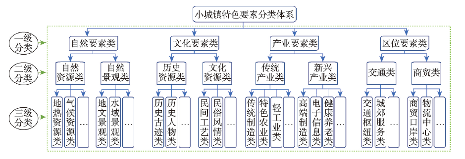
Characteristic model could help to break through some development difficulties for small towns. This paper attempted to construct a "three-step characteristics positioning method" based on the logical framework of "identifying characteristics-evaluating superiority-positioning characteristics" from microcosmic to macrocosmic view. First, characteristics identification mainly uses manual inspection and big data. Second, superiority evaluation needs different indicators or methods according to corresponding element category, through parallel comparison within the city. Third, characteristics positioning is based on the analysis of territorial types combined with the priority sequence selection from "natural element-cultural element-location element-industrial element". In addition, case studies of 15 characteristic small towns in Anhui Province were adopted to test the operability and practical value of the "three-step characteristics positioning method". Results showed that 20% of the cases failed to identify local characteristics reasonably due to the lack of positioning method and technical specification. Characteristic towns are suggested to verify the elements in time, and other towns should carry out characteristic-oriented positioning work before construction.
At present, the world is undergoing "profound changes unseen in a century", which bring great challenges to human security and development. The world is calling for the voice of political geography. Thanks to the unique development environment and strong discipline demand, political geography has been revived in China in recent years. A series of remarkable achievements have been made in terms of localized concept innovation, multi-source research data and method expansion, etc. On the other hand, some "thresholds" that need to be overcome in the development of the discipline have also become increasingly obvious. For example, the lack of consensus core concepts, the disunity of disciplinary paradigms, and the insufficiency of multi-scale research perspectives restrict the in-depth interaction between political geography academic research and policy application. In this context, based on the review of the development of Chinese political geography over these years, this paper discusses the basic problems that restrict the development of Chinese political geography, and puts forward four suggestions at present: (1) augmenting multi-scalar and cross-scalar researches; (2) strengthening policy researches for practical application based on substantial theoretical research achievements; (3) attaching more importance to regional studies; (4) promoting dialogues among civilizations and exchanges of thoughts on political geography between the East and the West. Only by forming three research directions: knowledge-oriented critical research, positivist academic research and pragmatic policy research, can we achieve a breakthrough in Chinese political geography and build a peaceful, realistic, and pragmatic Oriental political geography, which will bring a new landscape toward global governance in the new era.
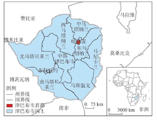
The world is currently undergoing profound changes unseen in a century, and how China builds its national image has become a complex and comprehensive issue needs to be urgently addressed. The study uses critical geopolitics theory as theoretical tool and employs a field survey in Zimbabwe as an empirical evidence to investigate Zimbabwe's geographical imaginations of China's national image and its related mechanism. The study found that the current Zimbabwe's geographical imaginations of China's national image is no longer dominated by the historical narrative based on its colonial history and the war of independence led by its national propaganda. In contrast, in the context of its fast-track land reform policy, China's "going out" strategic transformation and its increasingly close ties with the African continent, as well as the continuous global geopolitical turbulence represented by Trumpism, Zimbabwe's internal and external social relations has begun to undergo drastic changes. The relationships between various subjects (including states, governments, political parties, associations, enterprises and individuals) have also become extremely complicated and Zimbabwe's perception of China's national image has therefore no longer been influenced only by historical events. More specifically, China's national image is also influenced by Chinese enterprises, migrants, and their social practice in Zimbabwe. Moreover, these social practices have interacted and negotiated with the changes in Zimbabwe's internal and external social relations, thereby affecting the continuous deconstruction and reconstruction of China's national image in Zimbabwe. This study extends the understanding of discourse in critical geopolitics theory and strengthens the ability to solve problems. Practically, this study discusses the internal logic of other countries' building of China's national image, which has a certain reference value for the narrative of how to build China's national image in the context of global transformation.
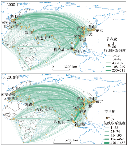
As the material carrier of international trade, the shipping network that has been formed between China and the countries along the Belt and Road is an important support for the prosperity and development of the Maritime Silk Road. In this paper, a complex network model was used to characterize the port shipping network between China and the countries along the Maritime Silk Road in 2008 and 2018. Then, the coupling characteristics of the network and trade of various countries were analyzed by constructing an index system to reveal the shipping network's ability to support trade. Finally, spatial heterogeneity of influencing factors was analyzed by using geographically and temporally weighted regression model. The results show that: (1) on the whole, the port shipping network in 2008 and 2018 had obvious complex network characteristics. Network density increased by 111%, while its overall operating efficiency decreased by 8.73%. (2) The coordination degree between the shipping network and trade increased by 5%. It is also noted that most well-performed countries were distributed in East Asia and Southeast Asia. By 2018, about 36% of the shipping network of countries along the Maritime Silk Road lagged behind the level of trade, resulting in a significant shortage of shipping support. About 28% of the shipping elements of countries along the route were oversupplied. Most of the remaining countries evolved from low-level coordination to intermediate coordination. From a regional perspective, the coordination of these countries had obvious space club convergence. (3) There were obvious regional differences in the factors influencing the coupling relationship. In general, the scale of trade, the efficiency of port shipping and the economic benefit of foreign trade are the most important factors that promote the synergy effect of the shipping networks and trade, while the coverage of liner routes, port transit capacity and trade barriers are not so influential.
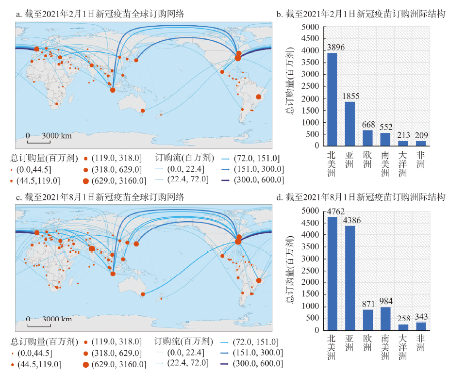
Using the data of global COVID-19 vaccine development, ordering, donation and vaccination, and through GIS and other technical methods, this paper depicts the development, circulation pattern and their dynamics of global COVID-19 vaccine. In order to provide a cognitive basis, this paper further discusses the spatial and temporal differentiation of global COVID-19 vaccination. The conclusions are as follows: (1) The global development pattern of COVID-19 vaccine is not balanced, with three cores in Western Europe, North America and Asia as a whole. Among them, the United States, China and the UK are the representative countries for the development of COVID-19 vaccine. (2) In the early stage, the global COVID-19 vaccine ordering was mainly distributed among developed countries in Western Europe and North America. Nevertheless, with the continuous expansion of the global ordering network, the ordering of COVID-19 vaccine has gradually expanded to Asian, African and Latin American countries. On the whole, the global COVID-19 vaccine ordering has formed two expansion modes, including directed expansion and non-directed expansion. (3) China and the United States are the two core countries of the global COVID-19 vaccine donation network. The United States mainly donates vaccines to Southeast Asia, South Asia, Latin America and other countries that have close relationship with the United States. China mainly donates vaccines to South Asia, Southeast Asia, West Asia and Africa. The donation of COVID-19 vaccine is mainly affected by the contact and relationship between countries, the national strategies and the need to fulfill international obligations of donor countries, but their focuses are different. (4) The development, ordering and donation pattern of global COVID-19 vaccine determines the evolution of global vaccination pattern. The vaccination process in developed countries in Western Europe and North America is ahead of most Asian, African and Latin American countries, but the gap is gradually narrowing. China's vaccination rate has jumped from a higher to the highest level, making China a representative of developing countries.