Hu Huanyong is one of the founders of modern Chinese human geography, a pioneer of geopolitical research and an outstanding thinker of geostrategy. This paper evaluates Hu Huanyong's geostrategic thought in the context of the changing international geopolitical environment in which China has embarked upon its path of national development. Hu Huanyong is believed to be the pioneer and visionary geographer who has long-term influence on China's geopolitical research and the formulation of China's geostrategy. He is credited for his systematic demonstration of the Chinese sovereignty over the islands in the South China Sea, namely the Nansha Qundao, Dongsha Qundao, Zhongsha Qundao, and Xisha Qundao, particularly his first naming of Nansha Qundao. He is ahead of his times with his comprehensive study of China's geopolitical environment, his prediction of the inevitable Japanese invasion into China and armed conflicts between Japan and the US, and his call for special attention to border governance and national security and defense. He has strongly advocated the recovery of the Ryukyu Islands, stressed the role that geographers play as the vanguards of China's territorial development, and called for a better integration of geography with national defense education. The paper concludes with an observation of the great significance to inherit and carry forward Hu Huanyong's geostrategic thought in the current global geopolitical environment characterized by unprecedented changes of the world in a century and the great rejuvenation of the Chinese nation.
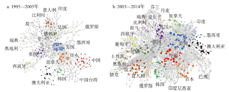
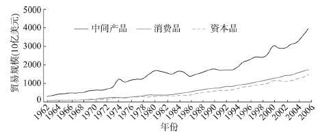
As China enters the new normal era, the existing mode of joining into the global production network is confronted with the dual dilemma of internal dividend disappearance and external trade frictions. It is very important to explore the characteristics and driving forces of dynamic evolution of industrial linkages between China and other countries or regions in the world. Based on the world input-output table database from 1995 to 2014, this study depicts the global industrial interdependence network from the national scale using input—output analysis and social network analysis, and focuses on the evolution of China's role and position in this pattern using spatial econometric model. The main findings are as follows: China has become a bridge between East Asia and Southeast Asia and other emerging markets, thus upgrading from an "outsider" to an important hub in the industrial network linking Europe and the United States. However, from 2015 to 2019, the expansion of China's foreign industrial linkages has gradually reached a plateau. From the perspective of supply side, China's resource and manufacturing industries are constantly embedded in the supply side of the global production network. However, the overall external supply capacity of most China's service industry is relatively below global average. In terms of demand, China, as the "factory of the world" and a major country in infrastructure construction, has an increasing global influence in manufacturing and infrastructure. Nevertheless, the international influence of productive services like Transportation, Logistics and Finance has been declining since 2005. The Chinese industries obtain the local added value overall to continue to grow, but the efficiency of the added value capture is low. On this basis, this study explores the influence of multi-dimensional proximities and trade protectionism on China-global industrial linkages and their value added. Among them, the geographical and cognitive proximity has the most extensive influence, while the social and institutional proximities only promote and strengthen the intermediate production linkage with more complex forms of industrial linkages and final demand linkages. However, technical barriers and anti-dumping investigation have weakened China's foreign industrial links. The sanitary and phytosanitary measures have a significant weakening effect on the final demand linkage, but not on the intermediate product production. To sum up, the upgrading of production-oriented service industry and the efficiency of the acquisition of overall added value are the potential directions for the expansion of China's foreign industrial linkages, while the construction of domestic industrial cycle and industrial diversification are the reasonable measures for the expansion of China's foreign industrial linkages.
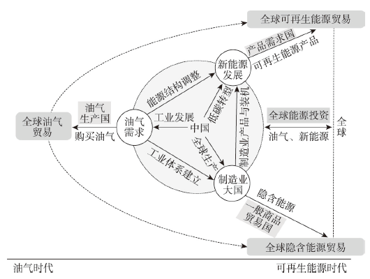
China is in the critical period of transforming from the oil and gas era to the renewable energy era. The changes of China's energy demand structure and energy utilization form determine that the energy interaction logic between China and the rest of the world has undergone profound changes. In order to better understand the process of energy interaction between China and the rest of the world, this study discusses the basic theoretical cognition of global energy interaction, and analyzes the pattern and changes of energy interaction between China and the rest of the world with the help of complex network, multi-region input-output analysis and other technical methods. It is found that the scope of energy interaction between China and the rest of the world is expanding and deepening. China has gradually shaped a diversified world energy map, converting from oil and gas to renewable energy trade, from oil and gas based investment to diversified energy investment, and from conventional energy trade to embodied energy trade. The main conclusions are as follows. (1) The coal-based energy production structure and the huge demand for oil and gas determine that ensuring overseas oil and gas supply is the most direct logic of energy interaction between China and the rest of the world, and the interaction areas are mainly concentrated in oil and gas rich countries and regions. (2) With the development of renewable energy, the logic of energy interaction between China and the rest of the world has changed from oil and gas to renewable energy related products trade. With the comparative advantages in China's manufacturing, the scope of interaction has expanded from countries and regions rich in oil and gas to countries with global renewable energy development and installation needs, forming a renewable energy trade map covering major countries and regions in the world. (3) China's overseas energy investment target has expanded from a limited number of host countries to other regions such as Europe and Southeast Asia. The investment business is not only limited to the oil and gas field, but also has expanded to solar energy, wind energy, hydropower and other renewable electricity generation projects. (4) China is a global manufacturing and trading power. Under the background of deepening globalization, part of China's energy is embodied the global production network and trade network for redistribution. The scope of energy interaction between China and the world is further expanded to countries with general commodity trade relations with China, forming the global "energy hub" function. This study can provide a theoretical perspective and decision-making basis for deeply understanding the energy interaction between China and the world, ensuring national energy security and participating in global energy economic governance.
From the perspective of economic geography, this paper studies the changing spatial pattern of world economy and China's role in different waves of economic globalization. Firstly, this study finds that the geographical pattern of world economy changes from "core-periphery" to "chain-reconfiguration", and to current "network-imbalance". Meanwhile the driving force of economic globalization shifts from "trade globalization" to "manufacturing globalization". At present, "multiple globalization" is involving into a new engine to driving the development of economic globalization. We then discuss that how China changes its role in economic globalization by changing modes of strategic coupling. We argue that the role transition of China breaks the traditional developing path which developed countries set for developing countries and theoretical spatial order put forward by classical industry gradient transfer, bringing new restructuring power and possibility for changing pattern of globalization. Finally, we discuss the impacts of COVID-19 pandemic on the development of economic globalization and the development trend of economic globalization in the post-pandemic era. Based on the analysis, we come up with some suggestions regarding to the potential development paths of China under the background of economic globalization.
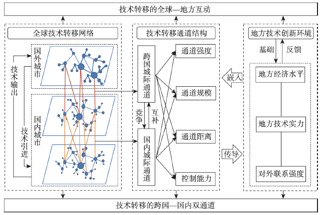
Patent transfer is an important channel for countries and regions to obtain technology from abroad, and it is also the most direct way to portray the relationship between supply and demand of technology flow. Based on the glocalisation perspective, this paper constructs a framework of technology transfer characterized by the transnational-domestic dual-channel theory. Combining social networks, GIS spatial analysis and spatial measurement models, it attempts to describe the spatial evolution and determining factors of transnational technological channels in Chinese cities. The research found that: (1) The spatial heterogeneity of China's transnational technology channel network is significant but gradually has weakened over time. (2) The transnational technology channel accelerates eastward movement, expanding from the technologically developed regions of North America and Western Europe (the New York Bay Area and Silicon Valley, the Caribbean offshore financial center, the London offshore financial center, etc.) to East Asia and Southeast Asia (Japan, South Korea and Singapore), China's technological dependence on the United States and Western Europe has been greatly reduced. (3) The Beijing-Tianjin-Hebei urban agglomeration, the Yangtze River Delta urban agglomeration, the Guangdong-Hong Kong-Macao Greater Bay Area and the northern Taiwan urban agglomeration with Beijing, Shanghai, Shenzhen-Guangzhou, Taipei-Hsinchu as the cores have become global technological innovation centres and hubs for transnational technology transfer flows. With the help of connections between headquarters and branch of multinational companies, offshore financial convenience and low tax advantages, Hong Kong mainly plays the role of technology intermediary and has become the city with the most technology transfer, while the core role of Taiwan Province is declining. (4) Intercity technology pipelines have a positive effect on transnational technology transfer pipelines. Enlarging the scale and flow of technology pipelines between cities and the distance between cities is conducive to expanding transnational technology introduction pipelines, while the intermediary of cities has no significant impact. In addition, the economic strength of a city has a positive influence on the promotion of transnational technology transfer pipelines, while technological strength and foreign economic relations have multiple effects.
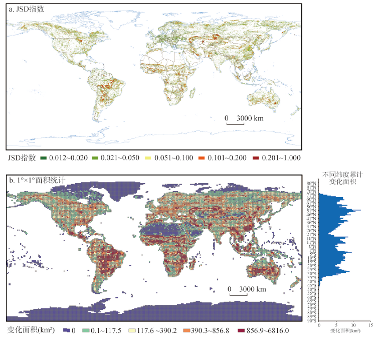
In recent decades, the global land cover has undergone drastic changes, and the impact of human activities on land cover change has become one of the most significant features of the "Anthropocene". The core tasks of coping with global "unprecedented changes in a hundred years" for China in the field of sustainable development is to scientifically assess the spatio-temporal process and new trends of global land cover change, analyze China's role and status in it, and propose optimal paths. We used geospatial analysis method and multi-source land cover data to explore the spatio-temporal process of global land cover change, analyze the transformation relationship between land types and the change trend of global "greening" and forest cover, and reveal the new characteristics and trends of land cover change in China. The results showed that the global land cover experienced significant changes from 1992 to 2015, and several hot spots formed, including central South America, sub-Saharan Africa, Central Asia, Southeast Asia and East Asia. China's forest coverage rate increased from 12.98% in 1990 to 23.34% in 2020, and the wetland area increased by 1908 km2, which contributed to the maintenance of global ecological security. The interactive conversion between cultivated land and forest is the most important land cover conversion relationship in the world. In terms of cultivated land occupied by urban land, China ranks first in the world, with an area of 73000 km2. The global leaf area index presented a global trend of significant increase from 1999 to 2019. With only 6.6% of the world's vegetation area, China contributed about 20% of the global increase in leaf area index and dominated the global "greening" process. The change of global forest coverage presents remarkably spatial agglomeration. China's forest area increased by 62.8376 million hectares (1990-2020), leading the world in forest restoration. The southwest China forest region and the Qinling-Daba mountains are the main areas of forest growth, and the Yangtze River Delta, the Guangdong-Hong Kong-Macao Greater Bay Area and parts of eastern Inner Mongolia are the main areas of deforestation. In the future, China should further enhance the balance and coordination between socioeconomic development and ecological protection, continue to promote the building of a beautiful China, and contribute more strengths and experiences to global ecological security and sustainable development.
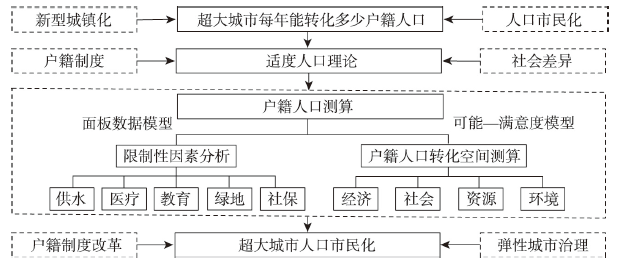
From 2020 to 2030, accelerating the citizenization of the floating population is the key to promoting new urbanization and achieving common prosperity. The urbanization rate of registered population in China is roughly 18% lower than that of permanent residents. The aging pressure and lack of labor force make big cities introduce relevant policies to attract talents, and the citizenization process needs to be improved urgently, with the focus on megacities. The transformation number of registered people in megacities varies greatly, and the academic world lacks research on this, which makes the transformation number of registered residents in megacities become an important academic issue. This paper, from both natural and social perspectives, selects concise indicators, and combines the Possibility-Satisfiability model to estimate the urbanization transformation gap of annual household registration, and constructs a panel data model to empirically analyze the factors leading to the gap of household registration in megacities. The main factors affecting the transformation of registered population in megacities are medical service, as well as educational resources and urban water supply. It is urgent for urban and rural administrators to change the passive and rigid institutional mechanisms and realize the flexible and normal governance.
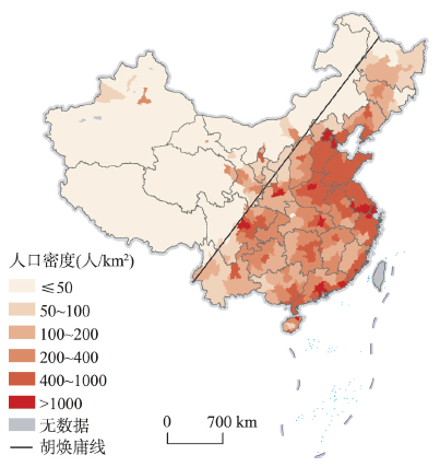
Using data of the latest three decennial censuses, this paper systematically analyzes the overall spatial pattern, changing trends, and influence mechanisms of China's population distribution since 2000. The study reveals that the general population distribution pattern of "dense east and sparse west" in China has not changed, which is determined by the differences in natural geographic environments on the two sides of Hu Line. In the first decade of the century, population concentration was mainly found in the southeastern area, but it has been observed in all regions in the recent decade. Provincial capitals have become the winners of population competition and the advantages of population growth of provincial capitals have been further strengthened in the recent decade compared with 2000-2010. However, the administrative power-led effects of the increasing dominance of provincial capitals will gradually weaken with the development of their provinces. The regional differentiation of population changes is also apparent: coastal region gradually forms a dense belt of population and towns with solid population attraction based on the development of urban agglomerations; the northeast region almost turns to a complete population shrinking status; central provinces still compete fiercely for population based on their capitals; the population of Sichuan, Chongqing, and Guizhou has stopped the decline and returned to growth; and the northwest region faces the risk of population loss. In addition, this paper finds that the driving factors of regional population growth have gradually changed from economic factors to both economic and amenity factors, and the difference of amenities among regions may become an important factor for future changes in China's population geography.
Access to homeownership profoundly affects floating population's social integration in the destination city and, in the long term, wealth accumulation. While housing differentiation within China's floating population has received increasing attention in the past two decades, the varied housing outcomes of the floating population experiencing different geographic mobility have been rarely investigated. Using data from the 2017 China Migrants Dynamic Survey, this study employs logistic regression models to examine the association between migrants' hierarchical migration patterns and their housing outcomes in the destination city. The results show that the migration patterns of China's floating population are mostly featured by moving up along the urban hierarchy. There are significant disparities in housing outcomes among floating population with different origins and destinations. Migrants originating from cities with higher gross domestic product (GDP) per capita and average housing prices are more capable to afford a home in the destination city. Moving to cities with higher average housing prices implies fewer opportunities to purchase local commodity housing. As GDP per capita in destination cities increases, the probability of floating population purchasing commercial housing increases first but then decreases, while the probability of purchasing housing with incomplete property rights exhibits the opposite phenomenon. Furthermore, migrants making larger upward movements are less likely to own a home in the destination city, but more likely to rent formal housing. This study highlights the role of geographical mobility between different origins and destinations in affecting floating population's housing outcomes in the destination city and furthermore provides insight into understanding housing inequality.
Based on the data of usual residence from 2000 and 2010 censuses and 1995 and 2015 micro-censuses and using the method proposed by Abel G. J., this paper estimates the O-D migration flows among prefectural-level administrative units in China for the period 1995-2015. By using the indicators of migration flows and migration rates, and the methods of GIS spatial analysis and community detection in social network analysis, it further reveals the characteristics of spatio-temporal evolution of migration in China since 1995. The results can be summarized as follows. (1) The scale and intensity of migration in China have been increasing, while their differences among regions have been gradually decreasing. This suggests that migration has experienced a gradual transformation from a "low-activity era" including a limited number of regions to a "high-activity era" involving the majority of regions. (2) Six regional types of migration among prefectural-level administrative units, namely, large-scale active net in-migration, small-scale net in-migration, large-scale active net out-migration, small-scale active net out-migration, active balanced migration and inactive migration, are identified. The spatio-temporal evolution characteristics of the regional types of migration in China indicate that each active migration regional type has been undergoing a change of continuous diffusion, while the inactive migration regional type has seen a significant reduction over time. (3) The spatial patterns of migration are quite different between regions on both sides of "Hu Line", manifested in the fact that the scale and intensity of migration flows on the southeastern side of the line is higher than that on the northwestern side, which means that the "Hu Line" is quite stable and robust in the last 20 years. (4) Patterns of migration flows indicate that while intra-provincial migration has continuously strengthened, inter-provincial migration has exhibited more complicated spatial patterns, mainly reflected in different changing trends of attractiveness to migrants among the three coastal city clusters, and the increasing migration flows within southwest China. As a result of combined effects of inter- and intra-provincial migration flows, the structure of migration flows in China's eastern, central and western regions has been undergoing changes, resulting in the internal differentiation of urban agglomerations and the declining spatial scope under their influence in the coastal areas, Hubei as the single independent "city community" in central China, as well as the relative stability in northwest China and continuous change in southwest China.
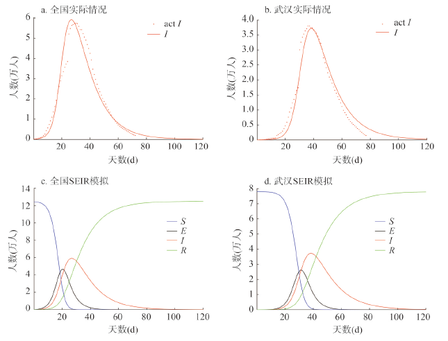
The Chinese government has curbed the rapid transmission of COVID-19 through a population flow control rarely seen in history. What is the effect of population flow control on pandemic prevention and control? How does it affect China's population mobility and short-term population distribution? In this paper, an SEIR model of virus transmission dynamics is used to evaluate the effectiveness of the control measures, and mobile location data are employed to track the temporal and spatial changes of population mobility in China, in order to review the positive and negative effects of population flow control during the major outbreaks of COVID-19: (1) Population flow control has significantly stabilized the daily new infection, serving as an essential part of China's non-pharmacological intervention measures in response to major public emergencies of COVID-19. Population flow control postponed the arrival of the peak day of daily new infections in China by 1.9 times, and reduced the number of newly infected people on that day by 63.4%. In the selected 5 provinces, 5 cities in Hubei, and 6 cities outside Hubei, the peak days were postponed by 1.4-8 times, 5.6-16.7 times, and 2.3-7.2 times, respectively, and the number of newly infected people on that day was reduced by 56.9%-85.5%, 62.2%-89.2%, and 67.1%-86.2%, respectively. Therefore, population flow control bought valuable buffer time for the prevention and control of the pandemic, and greatly weakened the impact of concentrated transmissions on medical facilities. (2) Population flow control limited intercity population flow. From January to April 2020, the average daily population flow intensity in China decreased by 40.18% compared with the same period in 2019. In particular, the coming-back-to-work flow after the Spring Festival travel rush in 2020 (from January 25 to February 18) decreased by 66.4% on average. (3) Population flow control and people's fear of the pandemic greatly affected the Spring Festival travel rush in 2020, and the spatial and temporal and distribution of China's population was changed for a short period. This paper helps the understanding of the impact of the population flow control strategy introduced by the government on major public emergencies, as well as the influences of geographical characteristics upon on the population flow and distribution.
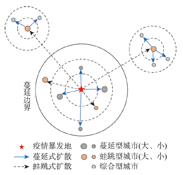
It is essential to unravel the spatial and temporal patterns of the spread of the epidemic in China during the backdrop of the global coronavirus disease 2019 (COVID-19) outbreak in 2020, as the underlying drivers are crucial for scientific formulation of epidemy-preventing strategies. A discriminant model for the spatio-temporal pattern of epidemic spread was developed for 317 prefecture-level cities using accumulated data on confirmed cases. The model was introduced for the real-time evolution of the outbreak starting from the rapid spread of COVID-19 on January 24, 2020, until the control on March 18, 2020. The model was used to analyze the basic characteristics of the spatio-temporal patterns of the epidemic spread by combining parameters such as peak position, full width at half maximum, kurtosis, and skewness. A multivariate logistic regression model was developed to unravel the key drivers of the spatio-temporal patterns based on traffic accessibility, urban connectivity, and population flow. The results of the study are as follows. (1) The straight-line distance of 588 km from Wuhan was used as the effective boundary to identify the four spatial patterns of epidemic spread, and 13 types of spatio-temporal patterns were obtained by combining the time-course categories of the same spatial pattern. (2) The spread of the epidemic was relatively severe in the leapfrogging model. Besides the short-distance leapfrogging model, significant differences emerged in the spatial patterns of the time course of epidemic spread. The peaks of the new confirmed cases in various spatio-temporal patterns were mostly observed on February 3, 2020. The average full widths at the half maximum of all ordinary cities were approximately 14 days, thus, resonating with the incubation period of the COVID-19 virus. (3) The degree of the population correlation with Wuhan city has mainly influenced the spreading and the short-distance leapfrogging spatial patterns. The existence of direct flight from Wuhan city exhibited a positive effect on the long-distance leapfrogging spatial pattern. The number of population outflows has significantly affected the leapfrogging spatial pattern. The integrated spatial pattern was influenced by both primary and secondary epidemic outbreak sites. Thus, cities should pay great attention to traffic control during the epidemic as analysis has shown that the spatio-temporal patterns of epidemic spread in the respective cities can curb the spread of the epidemic from key links.
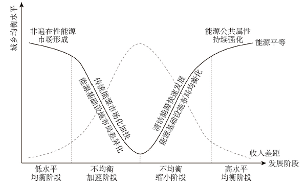
Energy transition is an effective path to peaking carbon dioxide emissions before 2030 and achieving carbon neutrality before 2060, which is an effective measure to bridge the gaps between urban and rural families' energy demand and realize energy equality. Based on the survey data from China Family Panel Studies provided by the Institute of Social Science Survey of Peking University, this paper takes the per capita residential energy cost as the key indicator, and applies three major tools to analyze the evolution of energy equality between urban and rural households during 2013-2017, including Gini coefficient and its decomposing technology, Lorenz curve and Lorenz asymmetry coefficient, Locally Estimated Scatterplot Smoothing, and Stepwise Regression. Then, the significance and economic burden of household energy transition was evaluated. The results show that: (1) On the whole, there are inequalities in household energy cost at present. However, with the implementation of national and local energy transition policies in recent years, the promotion of urban-rural integration, and the increase in the income of urban and rural households, the gap between urban and rural areas had been considerably narrowed during 2013-2017, thus its contribution rate to the national inequality dropped from 26.8% to 24.0%. (2) From the spatial perspective, energy inequality is most prominent in the temperate and humid region covering Yunnan and Guizhou, while the distribution of energy cost in the Yangtze River Delta, which is hot in summer and cold in winter, was relatively reasonable. Meanwhile, energy inequality has remained in the other regions to varying degrees. (3) Household income, household size, residential location, climatic conditions, and modern energy availability significantly affect household energy expenditures, which in turn affect energy equality within a region and between urban and rural areas. However, energy endowment does not have an obvious influence on the household energy expenditures. (4) In recent years, national energy transition had achieved remarkable results, and there had been a widespread coverage of advanced fuels. As the wide use of canned gas/liquefied gas, natural gas/pipeline gas, and electricity in rural areas, a rapid energy transition from primary to advanced fuels was accelerated. Meanwhile, compared with urban residents, rural households are often under greater economic pressure in the energy transition, that is to say, achieving energy transition in rural households will increase higher extra cost than that of urban households with the same per capita income. In addition, in the current process of energy transition, relatively low-income urban households and relatively high-income rural households are the main participants.
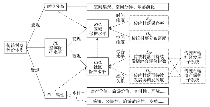
This study constructs a conceptual research framework for the protection of traditional villages, and focuses on the macro perspective of regional protection level and its influencing factors with geographic analysis techniques. The conclusions can be drawn as follows: (1) The conceptual research framework includes models of evaluation system and influencing factors. The evaluation system model includes three levels from macro to micro, namely, the spatial and temporal distribution, the overall protection level, and the single attribute. The evaluation of overall protection level is divided into the macroscopic regional protection and the microscopic community protection. Retention rates and distribution densities are the two important dimensions to evaluate the level of regional protection. The influencing factors model includes two types of basic analysis based on time, space, and the classification. (2) The regional protection levels of traditional villages in Southwest China show significant spatial differences, and five hotspots are formed in the boundary area of administrative divisions. (3) The geographical factors that affect the regional protection level of traditional villages in Southwest China are terrain, river system, central city, and arterial roads. Among the economic and social factors, the scale of intangible cultural heritage is the most important one. There are significant spatial differences in the correlation coefficients of population density, economic development, traffic construction, traffic flow, and the scale of intangible cultural heritage. Urbanization rate and industrial structure have no significant influence on the regional protection level. This research enriches the theoretical system for the protection of traditional villages from individual cases to an integrated study, from micro to macro, from scattered to systematic, from single to multiple methods, which has important theoretical and practical value.
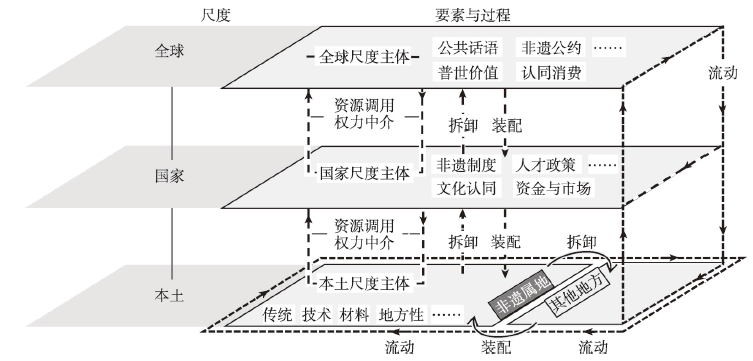
Intangible cultural heritage (ICH) encompasses not only local traditional practice derived from the past, but also future-oriented modern cultural political and economic processes generated due to globalization. Therefore, this paper uses translocal theory as an entry point to move beyond the paradigm of localities in analyzing the socio-spatial processes of intangible cultural heritage, with a specific focus on the processes of formation, operation, and identity. Accordingly, this paper reconceptualizes the practice of ICH. Different from the prevailing rigid, intrinsically stable, and human-centered approach, this paper adopts the idea of translocal assemblage to consider ICH practices as rhizomatic networks. The network binds heterogeneous elements together by power mediation to form temporarily stabilized systems. The translocal assemblage of ICH practices firstly connects human and non-human components as well as tangible and intangible components in different localities. Second, due to the openness of the deep structure, a translocal assemblage is a complex, multifarious, non-linear, and unstable whole with exteriority. Lastly, the structural linkages woven by power relations improve the current flat understanding of the world and emphasize the need to distinguish the intensity and criticality of different connections. Case studies of Heqing silver-forging technology and Mosuo textile technology use the three aspects above to identify when and where heterogeneous elements are linked and influence local development. This paper further argues that for better safeguarding of ICH as well as promotion of local development by heritage practices, attention should be given to elements and processes beyond the local, including their interrelation mechanisms with the local place. In valuing the potential of intangible cultural heritage to support development strategies such as rural revitalization, the article calls for consideration of the impact of trans-localism on heritage authenticity and cultural values together with the enhanced linkages between intangible cultural heritage and local identities and livelihoods in the light of global production and consumption of heritages.