It is very important to summarize the research, understand the development process and direction of industrial geography in China scientifically under the context of the development of international industrial geography. Based on 154 papers on industrial geography published in Acta Geographica Sinica from 1934-2019, this paper reviewed the development process of industrial geography in China and the progress of research in major fields. This paper showed that China's industrial geography is a unique theoretical system based on the integration of Western industrial geography theory and Soviet-style industrial geography theory, under the tasks of theory development and practices. Going through exploration, growth, perspective changing and deepening, industrial geography is gradually brought into line with the international researches on the content and paradigm. The development of discipline needs to meet the national strategic demand, raise theoretical innovation capacity, strengthen the application of new methods and techniques, and develop theories of industrial geography with the Chinese institutional context.
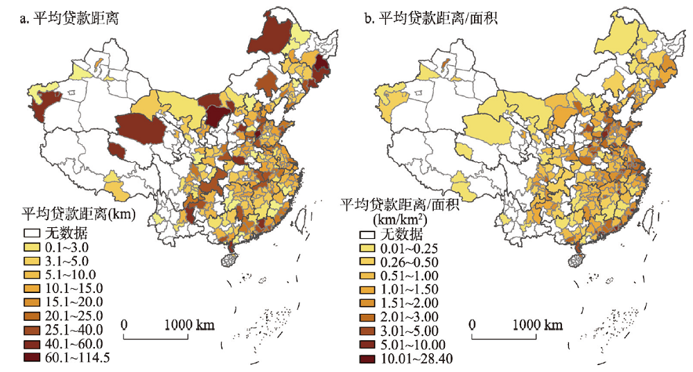
Geographical proximity not only helps to reduce information costs but also improves the relationship between banks and enterprises, thus increasing the availability of bank loans. This is why geographical distance affects the finance. We here found that geographical distance between banks and enterprises seeking loans had two effects on bank loans, namely, the "information effect" and "relationship effect". Based on the analysis of the mechanism by which geographical distance affects corporate bank loans, this paper uses the data of bank branches and loans made to private listed companies to characterize the average geographical distance of corporate loans at the municipal level and explore the impact of geographical distance on corporate bank loans. We here found the folllowing: (1) The geographical distance between banks and enterprises has a significant negative impact on the amount of loans. The closer the geographical distance, the greater the amount of money lent; the distance between borrowers and lenders in the same city or the same province showed a significant impact on the amount of money lent. (2) The distance between banks and enterprises in central cities, large cities, and developed cities tended to be greater than that in non-central cities, small cities, and developing cities. The influence of bank-enterprise geographic distance on corporate credit was more prominent in central cities, large cities, and developed cities. (3) Firm size, listing age, and history of state holding can reduce the effect of geographical distance on bank loans. (4) Informatization level and geographical distance have a substitutive relationship in terms of loan availability. The development of informatization can help reduce the restriction of geographical distance on bank loans but cannot eliminate it. The present work argues that it is of great importance to ease this constraint on enterprise financing.
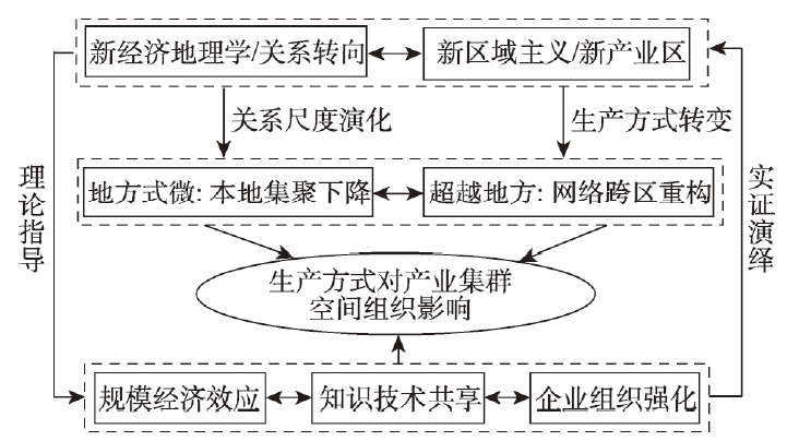
Under the background of the third revolution of production mode in the automobile industry, as represented by modularization, there arise a series of urgent theoretical and practical problems: how the new production mode affects the evolution of the spatial organization of the automobile industry, how to explain its mechanism based on economic geography, and how to analyze its effects on specific industrial clusters. Taking FAW-Volkswagen as an example, based on the local full-coverage first-level supply chain mapping industry cluster organization of vehicle manufacturing, this paper explores the effects of modular production on the spatial organization of automobile industry clusters at the local-regional scale. Results indicate that: (1) The degree of local agglomeration decreases with the decline of local economy. To a certain extent, the scale economy created by modular production overcomes transportation cost, leading to both the weakened production dependence of large-scale vehicle groups on the host area after industrial transfer and the reduced spatial agglomeration of parts suppliers. (2) Beyond locality: the production network between regions is reconstructed. Under modular production, regional production networks will be reorganized, which reflects the importance of scale production and scale reorganization for spatial economic dynamics. When the Yangtze River Delta region, with its regional advantages in the manufacturing industry and its complete auto parts industry chain, takes part in the division and cooperation of the production network of FAW-Volkswagen automobile factories in four cities across the country in the form of industry clusters, "beyond locality" competitive advantages are created. (3) Scale economic effect, knowledge technology sharing, and enterprise organization strengthening jointly drive the spatial reconstruction of China's automobile industry clusters under modular production. This study provides insight to understand the interactive mechanism between the adjustment of production mode and the evolution of the spatial organization structure of manufacturing industry clusters, offering beneficial complements to studies on industrial geography from the perspectives of economy, system, society, and innovation.
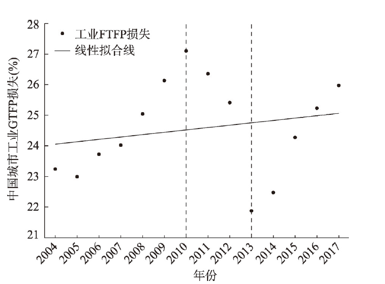
This paper expands the resource misallocation model based on the effect of price distortion. It measures the green total-factor productivity (GTFP) loss of urban industry due to land misallocation and analyzes its spatial and temporal changes by using the industrial input-output data of 285 cities in China from 2004 to 2017. The main results are as follows: (1) Capital misallocation still plays the most important role in the urban industrial GTFP loss, followed by land misallocation (10.5%) and energy misallocation. (2) The characteristics of industrial GTFP loss in Chinese cities induced by land misallocation can be summarized as "initially a small decline, then a large increase, and finally a large decline". Overall, the urban industrial GTFP loss increased, ranging from 1.10% to 2.48%. A correction in land misallocation is expected to bring about a 2% increase of industrial GTFP among Chinese cities. The characteristics of urban industrial GTFP loss due to land misallocation in the eastern and central regions are similar as that at the national level, while the loss in the western region maintains a high value with a slight overall decline. The eastern region is at the forefront of China's urban industrial development, and its industrial GTFP loss due to land misallocation dominates changes at the national level. (3) The spatial pattern of urban industrial GTFP loss in China due to land misallocation is characterized by contiguous clustering. The number of provinces with higher- and high-grade urban industrial GTFP loss has increased, gradually clustering in the northern region, mainly in the Yellow River basin. The number of provinces with low- and medium-grade loss has decreased and are mainly concentrated in the Yangtze River basin and the eastern coastal region. The total variation in urban industrial GTFP loss due to land misallocation among Chinese cities has been narrowed. The unbalanced allocation efficiency of urban industrial land in the three regions is the fundamental cause for the contrasting loss in urban industrial GTFP from land misallocation. In particular, the unbalanced allocation efficiency of urban industrial land in the western region is the main reason. The collaborative regional development in recent years is conducive to bridging the gap in the allocation efficiency of urban industrial land among the three regions.
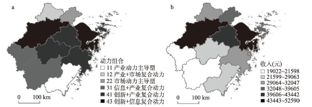
To explore the dynamic digital economy growth, regional differences, and the spatial distribution of regional income, this study takes Zhejiang Province, China's digital economy innovation highland, as a research sample, constructs the index system of dynamic factors of digital economic growth, and proposes the concept of a Digital Economy Growth Driving Index (DEGDI). Using the Weaver-Thomas model, grey correlation analysis, and GIS hierarchical coloring method, the paper analyzes the dominant driving force of digital economic growth in Zhejiang at the city level and verifies its relevance with regional income. The research results show that: (1) The dynamic characteristics of digital economic growth in this province fluctuates in a small range. (2) From the spatial pattern, the digital economic growth presents a "double core" phenomenon, in which Hangzhou and Ningbo are the cores. The industry-supply leading type is mainly distributed in the southwest of Zhejiang; the market-demand-driven, information-application-driven, and innovation-driven types are mainly found in the northwest part of the province. (3) There is a strong correlation between the DEGDI and regional income. The higher the DEGI, the higher the regional income, and vice versa. The change of the leading dynamics structure of the digital economy is forming a complex and diverse regional economic growth behavior mode.
It is disputable that global large-scale urbanization and climate change has become an outstanding issue, which requires the common concern of mankind. However, it is not yet clear what is the complex relationship between urbanization and climate change and how to scientifically deal with climate change in the process of urbanization. Further exploration from science and management to practice are needed in order to achieve global and regional sustainable development. This paper first displayed the basic facts of mass urbanization and climate change and summarized interactions and possible mechanisms of urbanization and climate change. Urbanization leads to heat island effect, uneven precipitation distribution and extreme weather, together with local-regional-global multi-scale superposition effect, which aggravates global climate change. The impact of climate change on urbanization is mainly manifested in the aspects such as changes of energy consumption, mortality and the spread of infectious diseases, sea level rise, extreme weather damage to infrastructure and water shortage. This paper also briefly reviewed relevant international research and joint actions, and put forward an analysis framework of multidimensional sustainable urbanization adapting to and mitigating climate change, from the perspective of key dimensions of urbanization, namely, population, land use, economy and society. We call on to strengthen the interdisciplinary research of science and humanities, take urbanization and other human activities into consideration of the land - atmosphere system, and explore the human-land-atmosphere coupling process. The adaptation and mitigation from the perspective of human activities represented by urbanization might be the most critical and realistic way to deal with climate change.
The lack of governmental and systematic urban population data limit the study progress in urban systems in China's historical period, which has great negative effect on quantitative analysis of urban system rank-size distribution. This paper digitized the "China Postal Atlas" in 1936, based on its 13240 postal points and more than 40000 km postal routes, and examined the spatial distribution of the kernel density of postal points and routes, using the Thiessen Polygon, Zonal Statistics and other GIS tools to give value to the postal capacity T of modern Chinese cities. T-value is used as a proxy for city size in modern China to analyze the rank-size rule. The conclusions are as follows. (1) The distribution of rank-size of cities in modern China based on the T-value was in accordance with Zipf's law. (2) In 1936, there were five postal aggregation areas in China: Beijing-Tianjin-Hebei region, the Yangtze River Delta, the Pearl River Delta, Wuhan and Chengdu-Baxian region, which is highly consistent with the current distribution of China's urban agglomerations. (3) In 1936, the spatial distribution of postal points and routes was very different on both sides of the "Hu Huangyong Line". The northwestern half to the line had a slightly smaller proportion of points than that of population, but a much higher proportion of high-grade points and routes than that of population. (4) In this paper, the sample size of urban system in modern China increased from about 200 (urban population) to 2360 (T-value). For the first time, the "three-stage" distribution caused by the unique "depression in the middle section" of the city size curve was found, which was quite different from that of the United States and China today. (5) The postal capacity T-value can be considered as a proxy for city size in urban geography studies in modern China.
This study constructs a theoretical framework of hedonic rent of urban housing and establishes the elements of housing characteristics suitable for rental housing. The elements include building, convenience, environment, and location characteristics. Based on the monthly data of 23126 houses available for rent in Guangzhou's urban district in March 2020, the spatial difference pattern and spatial correlation of housing rents in the district are analyzed through hierarchical spatial statistics and spatial autocorrelation. We established an index system of housing rent including 12 influencing factors. Through the comparison and selection of three models, the spatial error model is used to measure the influencing factors of housing rent, and the core influencing factors are identified. The results reveal that: (1) The theoretical framework and model of hedonic rent can be used to examine the influencing factors of urban housing rent. (2) Low- and middle-rent houses account for the largest proportion of rental housing in Guangzhou's urban district. Housing rent presents a spatial differentiation pattern that is higher in the core area and lower in the peripheral urban area and old city, with significant spatial agglomeration and correlation characteristics. (3) Four characteristics -- building (building area, orientation & floors, building age, elevator & property management), convenience (metro, office, education convenience), environment (park accessibility, industrial pollution), and location characteristics (distance from central business district (CBD)) -- including 10 factors, have a significant impact on the housing rent difference in Guangzhou's urban district. (4) Building area, building age, and distance from CBD are the three most important core influencing factors for housing rent, followed by elevator and property management and office convenience.

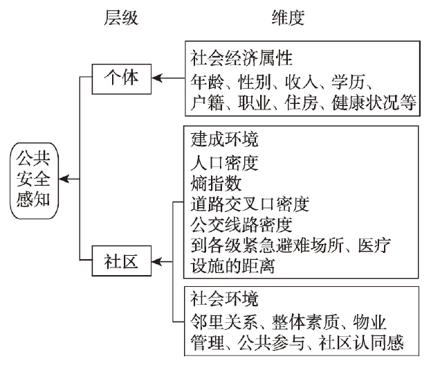
The novel coronavirus epidemic has led to an unprecedented concern regarding public security. Communities, as the basic units of social governance, play a prominent role during this period. However, little is known about the relationship between residents' sense of public security and their community environment in the existing geography and planning literature. To fill this gap in the research, this paper builds a theoretical framework to identify personal and community-level factors that influence the sense of public security. Based on a large-scale survey conducted in Beijing in 2019, we use multilevel linear models to analyze how and to what extent personal and community features impact this sense. The results show that (1) most of the personal attributes have significant effects on the sense of public security. Those who are older or less healthy are more likely to report a lower sense of security, and residents with lower incomes or education levels are also liable to suffer from insecurity. Stable employment has a positive effect on people's sense of security, and unemployed people report the lowest sense of security compared to others. Migrants feel safer than local residents, the main reason is that they compared their current city with their hometown and found Beijing to be much safer. (2) There is significant difference in residents' sense of public security across communities. The model results suggest that a built environment with a denser population and a bus route has a negative effect on the sense of security, while open space with more road crossings can improve residents' safety perception. Additionally, residents will feel more secure if their community gets closer to type I emergency shelters and hospitals. However, the influences of small- and medium-sized facilities are not significant, such as type II/III emergency shelters and community healthcare centers. (3) The social environment of the community plays a more important role in promoting residents' sense of public security than the built environment. However, it is found that renters can hardly benefit from the improvement of property management. Based on these findings, the paper provides some suggestions for improving the community's safety and resilience.
Over the recent decades, China has become an ageing society and how to best take care of the elderly has been in heated debate. Nursing homes have been considered as an effective way to solve the problems associated with the care of the elderly in China. To address these problems, it is of great significance to better understand the spatial distribution of nursing homes in Chinese cities and investigate why their distribution differs in space. This study used crawler technology to obtain the number of nursing homes in 285 Chinese cities by September, 2019, and applied a geo-visualization technique to map their spatial distributions. A novel spatially stratified heterogeneity method (named geographical detector) was employed to uncover the socio-economic driving factors of these nursing homes. The following findings were obtained: (1) The spatial distribution of the number of nursing homes is similar to that of the elderly population in the investigated cities, indicating that there is a close relationship between them. (2) The results of the factor detector test showed that the urban elderly population, urban economic development level, fiscal expenditure, the number of employees joining urban basic pension insurance, and the area of green land is closely related to the number of nursing homes in Chinese cities. Of these five socio-economic driving factors, fiscal expenditure and the level of economic development are the main drivers. (3) The results of the interaction detector test showed that the interaction effects of pairwise factors on nursing homes are stronger than the effect of individual factor. This indicates that the spatial heterogeneity of the number of nursing homes is affected by multiple factors. Moreover, the interactions between the elderly population factor and four other driving factors are the strongest determinants for the development of the number of nursing homes of Chinese cities. Finally, several relevant policies are proposed to promote the increase of nursing homes in Chinese cities based on the main findings.
Urban natural environment especially greenery environment has been consistently linked to better health outcome. Previous studies have shown that the greenery environment of neighborhood is related to residents' health, but scant attention has been paid to biopsychosocial pathways through which neighborhood greenery affects resident' wellbeing. In addition, a limited number of studies have evaluated the healthy pathways between neighborhood greenery and residents' wellbeing among Chinese vulnerable groups in urban setting. Based on neighborhood effect, three potential mediating pathways (namely, increasing physical activity duration, reducing psychological stress and facilitating social interaction) linking neighborhood greenery to residents' self-rated health were explored from 757 participants of Guangzhou, China. In view of questionnaire data involving 30 communities and greenery data obtained from remote sensing image and streetscape data and etc., this research employed multilevel linear regression model and mediating effect model and propensity score matching method to examine biopsychosocial pathways and mechanism linking neighborhood greenery to residents' self-rated health, as well as the difference among different social strata (e.g. different income and gender groups). According to this empirical analysis, the following conclusions can be achieved. Firstly, residential neighborhood greenery is significantly associated with residents' self-rated health outcome. Secondly, reduction in psychological stress is a kind of pathway linking residential neighborhood greenery to residents' self-rated health. Thirdly, the impact of neighborhood greenery on residents' self-rated health differs significantly among different social strata, and neighborhood greenery has greater impact on the self-rated health of low-middle income residents and female residents group, which means the beneficial effect of reduction in psychological stress on self-rated health is strengthened by neighborhood greenery. This research findings enrich the empirical research on greenery environment and public health from the perspective of health geography, and suggest the necessity of improving active spatial intervention and greenspace construction of the "healthy community" at the neighborhood scale in promoting residents' wellbeing in Chinese urban settings.
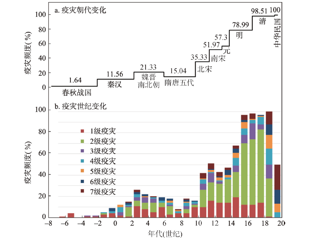
Epidemics are one of the most severe events in the human disaster network. On the basis of establishing the epidemic sequence by using historical epidemic data, and using the methods such as historical section analysis, factor correlation analysis, and time sequence analysis, this article examines the spatiotemporal characteristics and causes of the epidemic disasters for the past 2720 years (770 BC-AD 1949) in China. The results show that: (1) The frequency and intensity of epidemic disasters in China have a long-term upward trend, with troughs in the warm periods and peaks in the cold periods. (2) The epidemic prevalence in China generally occurred mainly in summer and autumn, but varied with time, so that since the 1450s, the seasonal difference tended to be less significant due to the increase of the kinds and frequency of epidemics. (3) China's epidemic fluctuation cycles are mainly 620-610 a, 320-310 a, 230-220 a, 170 a, 90 a, etc., which confirms the existence of "Twelve Earthly Branches" cycle and the significant impact of sunspot activity on the epidemic cycles. (4) For the past 3000 years, within the China's territory, the Epidemic Widespread is 93.51%, which indicates the percentage of the number of affected counties to the total number of counties, and the Epidemic Thickness is 16.86 layers, which represents the ratio of cumulative affected counties to the total number of administrative counties. The epidemics in the southeast half of China occurred much more frequently and severely than those in the northwest half. (5) The expansion of the epidemic prevalent areas in China is synchronized with the areal land exploration. The change of the epidemic centers of gravity is obviously affected by the spatial changes of the economic centers of gravity. The centers shifted from north to south before the Southern Song Dynasty, and moved from east to west after that. The import of foreign infectious diseases has a great impact on the distribution pattern of epidemics in China. (6) The prevalence of epidemics is not only a natural phenomenon, but also a sociocultural phenomenon. The change in the spatiotemporal distribution of epidemics reflects the change of human-environmental relationship. The densely populated areas, the areas along the traffic line, the surrounding areas of the capital city, the natural foci areas and the disaster-prone areas are all epidemic-prone areas. (7) The geographical environment has a basic impact on the spatial distribution of epidemics, that is, low altitude, warm and humid areas are prone to the prevalence of epidemics. Natural disasters can induce epidemics, so the disaster-prone area is also the epidemic-prone area, and the disaster-prone period is also the epidemic-prone period. Climate change has impacts on epidemic fluctuations, so epidemics are more frequent in the cold periods than in the warm periods. The land excessive development and the conflict between human and land resulting from population growth intensified the epidemic prevalence. Moreover, epidemics always follow wars, that is, the frequent periods of war are also the frequent periods of epidemic.
A transportation hub is the key link in the construction of the comprehensive three-dimensional transportation corridor of the Yangtze River Economic Belt (YREB), and it is the basic factor responsible for the promotion of this belt. A high-speed railway hub has the effect of "last kilometer of time-space compression" and is the key to building an efficient, convenient, modern, and comprehensive transportation system. Based on the principle of this effect, this study constructed a model for measuring the connection-distribution performance of the high-speed railway hub, determined the connection-distribution performance of the urban high-speed railway hub in the YREB, and analyzed its spatial differentiation characteristics, and further revealed the influencing mechanism of the connection-distribution performance of the high-speed railway hub. The main results are as follows: (1) the connection-distribution performance of the high-speed railway hub in the YREB presented an "olive type" grade structure with two small ends and a large middle section, that is, there are fewer high-speed railway stations with high performance and average performance, and there are more high-speed railway stations with good performance and medium performance. (2) The connection-distribution performance of the high-speed railway hub in this economic belt showed a regional differentiation pattern of "high in the east and low in the west" and "high in the north and low in the south", and showed an urban agglomeration differentiation pattern of "high in the core area and low in the marginal area". Moreover, spatial differences were prominent in the distribution of nine evaluation indexes of the connection-distribution performance of the high-speed railway hub. (3) GDP, urbanization rate, city level, station passenger flow and frequency of shuttle bus were key driving factors affecting the connection-distribution performance of the high-speed railway hub. At the same time, there were significant differences in the key driving factors for the connection-distribution performance grades of high-quality, good, medium and average levels.
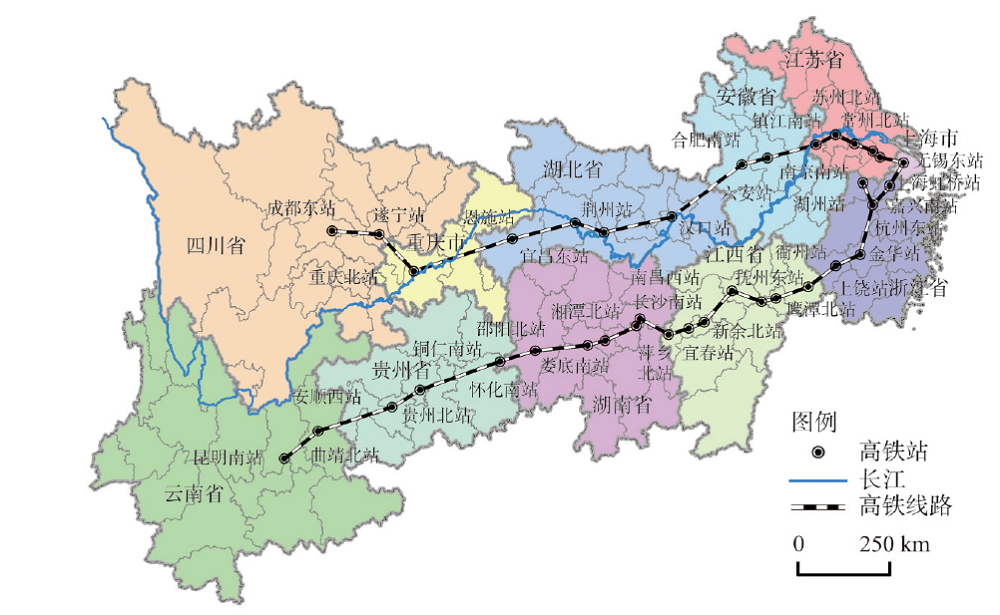
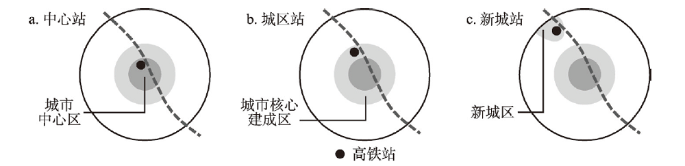
High-speed railway (HSR) station is regarded as a new type of space for driving urban economic growth, and studying its surrounding industrial structure is of great significance to guide the development of HSR station areas. In this paper, nine HSR stations with different locations and different levels in China are selected as the research object. The Point of Interest (POI) information data of 10 industries within 3000 m around the HSR station are used as the research basis. Based on the Ripley's K function, kernel density estimation and industrial indexes, the characteristics of industrial distribution of HSR station areas in different locations are explored. Our result indicates that when the grade of high-speed rail stations is the same, the farther the high-speed rail stations are from the city center, the smaller the total number of industrial POIs in the station area. Among 10 kinds of industries, the number of POIs in four types of industry, namely, shopping services, catering services, life services and companies, is much larger than that of other industries. Secondly, all industries in the HSR station areas show a significant agglomeration within an observation distance of 1500 m. In terms of the industrial agglomeration degree, the change of the central station is relatively gentle, the change of the urban station is the highest, and the change range is greater, and the regularity of new-town station is not obvious. Thirdly, the industrial agglomeration area of the central station is mainly distributed in the range of 0-2500 m around the high-speed rail station, the industrial agglomeration area of??the urban station is more obvious in the range of 500-2500 m, and the industrial agglomeration area of the new-town station is concentrated in the ranges of 0-1500 m and 2000-3000 m. Fourthly, the basic service industry and derivative service industry are mainly concentrated in the inner and the middle circle layers, and the related service industries are mainly distributed in the middle and the outer circle layers. The compound characteristics of the industries in each circle layer are obvious, and the farther away from the city center, the weaker the radiation effect on the industry, the more obviously the trend of industry decays. Finally, based on the research findings, it is believed that the government should pay more attention to the intensification of land development and the integration of industrial development while developing the industries in HSR station areas.
With the increasing complexity of tourism destination development, nonlinear research method has become an effective way for tourism destination evolution research. This paper, with Shanghai as a case study, takes the tourism demand as the dynamic behavior representation of the complex system of the tourism destination by using the method of horizontal visibility graph. It explores the evolution process and dynamic characteristics of the complex system of tourism destination. Result shows that the evolution of tourism destination complex system is featured by a small world and approximate scale-free network, which is characterized by chaotic dynamic behavior and chaotic deterministic nonlinear dynamic system. The evolution of the complex system of Shanghai tourism destination is in the chaos of "order in disorder" or the edge of chaos. The original order of the system has collapsed, and new attributes and structures have emerged gradually, and then they will form a new advanced order. The complex system of tourism destination follows the process of "order - chaos (edge) - emergence - new order", from low order to high order. The major events dominated by the external environment and the main system are the "key elements" of the evolution of complex tourism destination system from low-level order to high-level order. The improvement of the government's learning and innovation ability acts as a "propeller" in the system's phased evolution. Tourism enterprises begin to play a critical role and become the leading force to promote the development of complex system of Shanghai's tourism destination in the future. International inbound tourism source countries of Shanghai (Japan, South Korea, Singapore, Germany, Britain, France, Canada, and Australia) and domestic foreign tourism market are in an unstable chaotic region, which is an important factor affecting the chaotic behavior of the complex system of Shanghai's tourism destination. We should control the chaos, strengthen the management and guidance, and promote the formation of orderly state in the new evolution stage of the complex system of Shanghai's tourism destination.
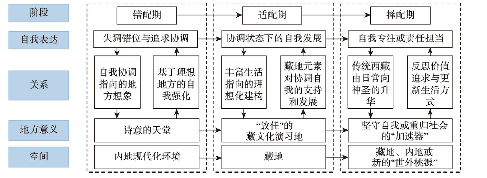
Tibet drifters, a typical group who utilize special place to fight against the negative effects of modernity, have special life courses of drifting in Tibet which can provide vivid cases for the study about mutual-construction mechanism between self and place. Based on the research data collected through semi-structured interviews and field observation, this study analyzes the evolution of the relationship between Tibet drifters' self-expression and place meaning under different spatial and temporal conditions from the micro diachronic perspective. The results show that the relationship has significant characteristics in different periods: During the mismatch period, Tibet drifters strengthen their self-expression by understanding Tibet as a "poetic paradise"; during the adaptation period, while continuing to pursue an indulgent self-concept, Tibet drifters also produce highly subjective and individual place meaning; during the selection period, as Tibet is becoming more modern and individuals are entering new life stages, Tibet drifters gradually develop diverse self-expressions and place meanings. On this basis, the study argues that the spatio-temporal interaction between Tibet drifters' self-expression and place meaning can be manifested as continuous pursuit of authentic meaning at different periods. In the whole process of sojourning to Tibet, this authentic meaning is expressed as ordinal arrangement from self-authenticity, experiential authenticity to value authenticity, which shows an extrapolating trend from self to friends, family and place. The main contribution of this study is to clarify the presentation of periods and development pattern of the core meaning of human-land relationship in the process of Tibet drifters' search for self-restoration and place support from two basic points of self and place at the same time, in order to provide a useful supplement for exploring the evolution pattern of sojourners' value pursuit, the linkage mechanism of human-land relationship and the modernization development of ethnic areas.