The coupled urbanization and eco-environment system is an important aspect of coupled human and natural systems. However, the time-space compression, long range interactions, and reconstruction of socio-economic structure at the global scale pose great challenges to the traditional analysis frameworks for human-nature systems. We are in urgent need of developing a brand new analysis framework. In this paper, based on the connotation of the coupled urbanization and eco-environment system and its four dimensions — space, time, appearance and organization, we propose a conceptual framework "Coupled Human and Natural Cube (CHNC)" to explain the coupling mechanism between urbanization and eco-environment, which is inspired by the theories including human-earth areal system, telecoupling, planetary urbanization, and perspectives from complexity science. We systematically introduce the concept, connotation, evolution rules and analysis dimensions of the CHNC. It is worth noting that there exist various "coupling lines" in the CHNC, which connects different systems and elements at multiple scales, and forms a nested, interconnected organic bigger system. The rotation of the CHNC represents the spatiotemporal nonlinear fluctuation of the urbanization and eco-environment system in different regions. As the system exchanges energy with the environment continually, the critical phase transition occurs when fluctuation reaches a certain threshold, and leads to emergence behaviors of the system. The CHNC has four dimensions — pericoupling and telecoupling, syncoupling and lagcoupling, apparent coupling and hidden coupling, intra-organization coupling and inter-organization coupling. We mainly focus on the theoretical connotation, research methods and typical cases of telecoupling, lagcoupling, hidden coupling, and inter-organization coupling, and finally put forward a human-nature coupling matrix to integrate multiple dimensions. In summary, the CHNC provides a more comprehensive and systematic research paradigm for understanding the evolution and coupling mechanism of the human-nature system, which expands the analysis dimension of coupled human and natural systems, and provides some scientific supports to formulate regional sustainable development policies for human wellbeing.

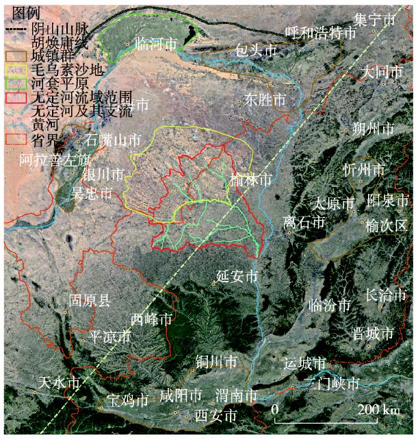
The Wuding River is one of the main branches in the middle reaches of the Yellow River, flowing through the Loess Plateau in northern Shaanxi. This paper analyzes the positions as well as the beginning and ending dates of the counties in the Wuding River Basin, from 300 BC to 1900 AD. Based on the history of administrative divisions, economic and social developments, and regime changes, three spatio-temporal patterns of towns evolution process in this river basin are found: (1) Influenced by the cyclical fluctuation of climate, the rise and decline of towns in the river basin has obvious periodicity, and the geometric center of the towns in this basin has obvious characteristics of tidal movement in a "northwest- southeast" direction. (2) The life spans of the town sites are generally short, and there were four stages with four different central towns in history. The direction and process of the movement of the central towns were consistent with the trend of the tidal movement of the geometric center of the towns. (3) In the history of the river basin, there were three types of towns spatial patterns: along the river valleys in the Qin-Han and Sui-Tang periods, along the border lines and the Great Wall in the Song and Ming periods, and along the lower reaches of the river basin in the Yuan and Qing periods. Based on the analyses, the authors suggest that to rationally determine the scale and layout of the towns system, the future development plan for the Wuding River Basin should focus on the long-term impact of climate change on towns distribution and the reality of regional environmental vulnerability.
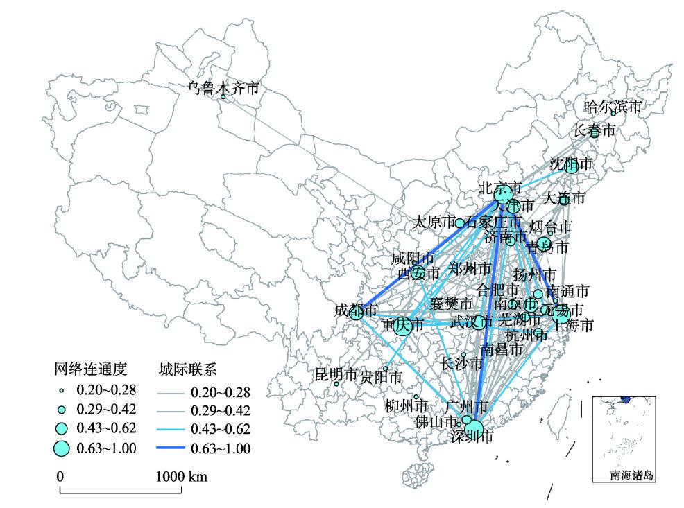
Based on the interlocking network model and the complex network theory, this paper analyzes the spatial distribution and interaction of cities based on geographical distribution of equipment manufacturing enterprises. The study indicates that cities all over the country present a hub-network structure. Beijing is the national hub city of the network. Cities such as Shanghai, Shenzhen, and Chongqing are regional hub cities. Beijing and Shenzhen have the strongest intercity connection in the network. Most cities in the northwest and southwest have a relatively low connection with other cities in the network. By comparing the sub-networks of different industries, it is found that there are significant differences in network scale, hub city and network density, which proved the polycentricity and diversity of urban space organizational hub-network structure. Finally, complex network theory is used to deliver deliberate attack experiments. The experimental results show that the network connectivity is basically not affected when the hinterland of the hub city is deleted, while the network connectivity declines obviously when the non-hinterland of the hub city is deleted. This indicates that the restriction of spatial distance between hubs and nodes is getting weaker, which is significantly different from the central-hinterland structure.
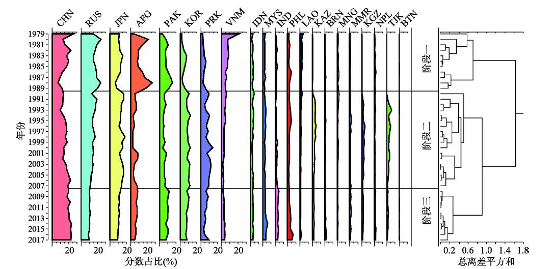
Geo-relationships, as an important field of research in geography, have attracted much attention from scholars. Quantitative research on geo-relationships based on big data is an important supplement to traditional geo-relationships study. This paper uses GDELT mass media data to express the geo-relationships between China and its neighboring countries as a global relationship of cooperation and conflict, and identifies the stage division of these relationships using ordered cluster analysis. Social network analysis is conducted for each stage of the cooperation and conflict relationship, and community detection is used to further analyze and interpret the networks of cooperation and conflict. Finally, we highlight bilateral relations in various stages and conduct a China-centered equilibrium analysis. Three main results are presented. First, from 1979 to 2017, the cooperation and conflict relationship between China and its neighboring countries demonstrated an obvious three-stage temporal division. China has gradually become the center of the network, and a broad cooperation pattern centered on China and supported by Russia, Japan, and South Korea has formed. Second, the highlighted bilateral relations in each stage, such as China-Vietnam, China-Japan, China-Russia, and DPRK-ROK, show varied development trends and driving factors. Third, with the process of China's peaceful rise, cooperation between the country and its neighbors is becoming more and more balanced, and conflict between them is expanding.
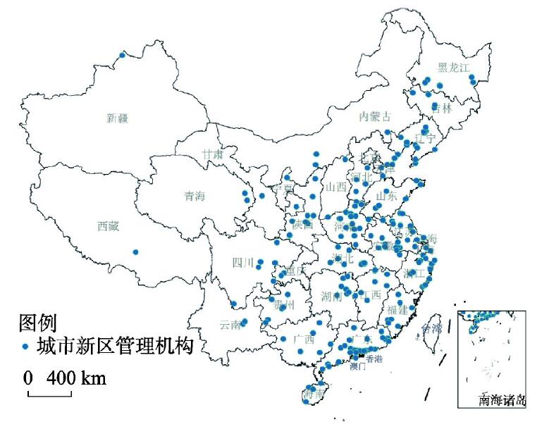
New Urban Districts (NUDs) are the important spatial carriers of urbanization. Since the reform and opening up in China, NUD has been playing a more and more crucial role in the process of urbanization, and has undergone a surging growth in recent years. NUDs in China are unique because of the most widespread 'building city' movement. Many researches focus on new districts or new towns in the broad sense, but little research has been done in a narrow sense in academia. The development of comprehensive NUDs will be of great significance to the sustainable transformation of China's cities in the future. Based on the critical theory of spatial production, this paper examines the spatiotemporal evolution and internal logic of NUDs. The establishment and development of NUDs is a rapid and trinity dialectical process of spatial production: representations of space is guided by the top-down governmental power; spatial practice is reflected in the hierarchical and regional difference of spatial elements, such as type, pattern, distance and area of NUDs; spaces of representation are the tensions between governmental power and urban development rights, as well as the countermeasure mechanism. In this trinity dialectical process, the extensibility of spatiotemporal sequences ensures the unity and continuity of spatial production or reproduction of NUDs. However, under the governmentoriented model, NUDs are also facing a series of challenges like the management coordination of administrative area and the increasing unbalanced regional development. Thus, it is time to keep a critical thinking and reinterpretation for the development of NUDs in China, which should be a key concern to achieve balanced regional development and new-type urbanization in the new era.
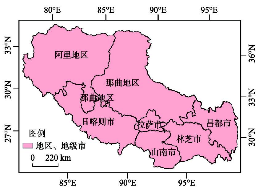
As natural resources are experiencing rapid reduction and the environment is degenerating, resource environmental carrying capacity has attracted more and more attention in China. However, current research on resource environmental carrying capacity still stays at theoretical level leaving the gap with applications. Moreover, the study conclusions are usually not of policy implications and lack of operability. This study develops a comprehensive analytical framework for the co-development of industries, population, economy, resources and environment. The framework first evaluates the importance of all industries to local social economy and determines the direction of industrial structure adjustment, and then identifies the interaction relationships among the socioeconomic development, resource consumption and environment emission, and subsequently evaluates the resource environmental carrying capacity, which helps achieve the maximum socio-economic development under the premise of environmental protection and efficient resource utilization. The Tibet case study estimates the local resource environmental carrying capacity under different development scenarios and therefore determines the maximum population and economic scale through industrial structure adjustments under the constraints of resource and environment. The results show that to focus on the development of tourism can significantly improve the resource environmental carrying capacity of Tibet. The results could help make decision regarding local industrial structure adjustments to achieve sustainable development. In conclusion the proposed analytical framework provides an operational decision support tool for "socio-ecological" sustainability. It can be extended to other regions through minor parameter adjustments.
The decline of countryside has become a worldwide problem nowadays, which is why cracking rural diseases is the key to revitalize the countryside. Existing rural researches mainly focus on one single system, rural transformation or specific issues, but there are few studies on the rural system and its subsystems, and the internal driving logic of rural development. Based on data of counties in the Huang-Huai-Hai Area, this study characterized the spatial pattern of the coupling coordination degree through rural inner systems, which include 3 subsystems of population, land and industry. Furthermore, it discussed the internal driving logic of rural development driven by population-land-industry. The results show that: (1) The rural population-land-industry development in most counties in the Huang-Huai-Hai Area is at a high-level coupling stage, and there are 4 obvious high-value axes in the spatial pattern. Meanwhile, the development level of the rural system is increasing year by year. (2) The coupling coordination level is relatively high in rural areas of the plain, but most parts are in the stage of reluctant or primary coordination. Counties with high-level coupling coordination are centrally distributed in economically developed areas. (3) The rural coupling-coordination relationships in the study region can be divided into 3 types: low coordination level-land development leading, middle coordination level-population development leading, high coordination level-population-industry development leading. The industry is of vital importance in the coordinated development of rural areas in the Huang-Huai-Hai Area. (4) The coordinated development of rural population-land-industry can effectively activate the "four forces" and lay the foundation for sustainable development in rural areas. This study provides a guidance for understanding rural system, solving the rural diseases and realizing the sustainable development in rural areas.

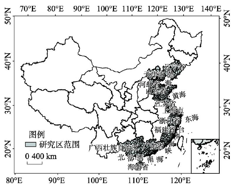
Based on the Global Tide and Surge Reanalysis (GTSR) dataset, the relevant Digital Elevation Model (DEM) was imported into ArcGIS and spatial analysis tools were used to extract possible flooding ranges due to sea level rise in 11 provinces and cities of coastal China. Combined with population, economic, and land use data, a sea level rise risk exposure assessment model is constructed and the population and economic risk exposure from sea level rise in coastal region of China are assessed. Three primary conclusions are drawn from the evaluation: (1) The impact of sea level rise on the coast areas is mainly concentrated in the Yangtze River Delta and northern Jiangsu coastal plains, as well as the Pearl River Delta and Bohai Rim, and other coastal plain areas. The most seriously affected land use types are arable land, which accounts for 65% of affected areas, followed by construction land; (2) Based on population and economic statistics from 2015 and 10 to 1000 years return periods, sea level rise increases risks to populations and the aggregated economy. In terms of sea level rise risk exposure, Guangzhou is most exposed and other areas with high exposure are concentrated in the Yangtze River Delta, northern Jiangsu coastal plains, the Pearl River Delta and Bohai Rim Region; (3) Based on population and economic statistics estimated using five shared social economic paths (SSPs), and variations in return periods from 10 to 1000 years, the gross population and the aggregated economies for 2025 and 2100 tended to increase in different paths. The conventional development path (SSP5) resulted in the largest affected population and aggregated economy while the local or inconsistent development path (SSP3) and unbalanced development path (SSP4) resulted in lower impacts than those of the other three paths. Changes in the return period from 10 to 1000 years can shift the risk exposure. Comparing the exposure risk to the population and economies, we found that the exposure degree in 2100 will be lower than that in 2025.
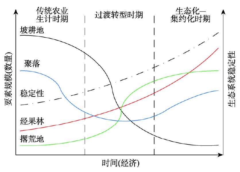
The Three Gorges Reservoir Area (TGRA) is a typical ecological vulnerable area with a characteristic of rural, mountainous and immigrant areas, therefore, it is of great significance to study the traditional agroecosystem changes in the TGRA for rural development and revitalization. According to the framework of "theoretical analysis - empirical study - trend prediction", this paper, taking the Caotangxi watershed as an example, analyzes the transition and trend of the traditional agroecosystem in the mountainous area of TGRA from the spatial change of man-land relationship by combining the Quick Bird high-resolution remote sensing images from 2012 to 2017, the natural resources and the farmers' behavior. The results show that: (1) the agroecosystem in the TGRA can be divided into four models by using buffer rings of 100 m interval, namely, the high-low-low, high-low-high, low-high-low and low-low-high. Different models, which represent the agricultural development stages in the TGRA, can reveal the trend of traditional agroecosystem transition from traditional way to modernization. (2) The agroecosystem in the TGRA is gradually transforming from the extensive agricultural land use to the intensive utilization way characterized by the rationalization of planting structure and species diversity within a range of 300 m around the settlements, through the ecological restoration way such as the abandonment of sloping farmland and the planting of economic fruit forest in the traditional farming area. (3) The traditional agroecosystem in the TGRA, represented by system elements such as farmers and sloping farmland, is undergoing transformation. Among them, the sloping farmland has mostly transformed from the type dominated by production function to the type with an equal emphasis on ecological and economic functions, the way of farmers' livelihood has tended to diversify, the ecosystem vitality of settlements system has gradually increased, and the change range of agroecosystem transition has basically migrated from high mountain area to valley flat area. Additionally, although there is a deficiency in study time limit, the results still have enlightenment for the rural land use, the control of soil and water loss and the improvement of rural living environment of the mountainous areas in the TGRA.
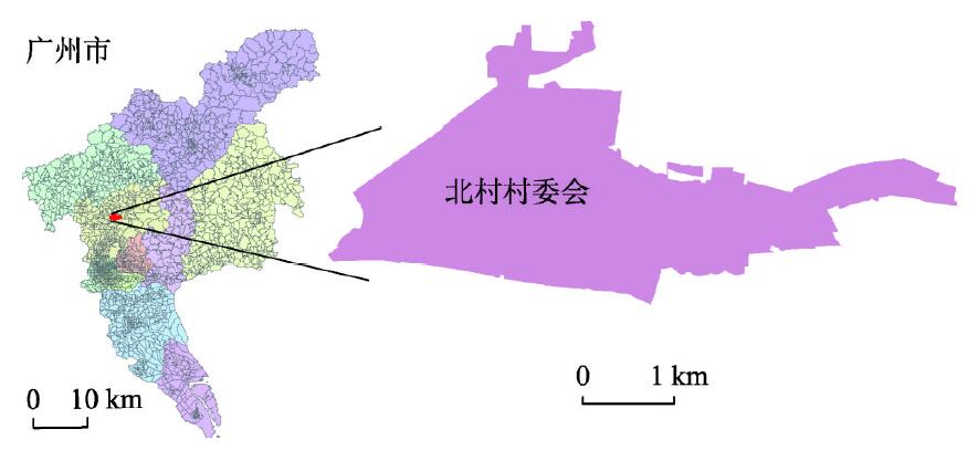
The reforms of global production modes and social systems have accelerated the process of urbanization, and the urban-rural flow speeds up spatial differentiation in the rural suburbs. Based on spatial production theory and game theory, this paper analyzes the spatial differentiation and its influence mechanism in Beicun in the suburbs of Guangzhou. The results are as follows: (1) Since the 1980s, Beicun has experienced three stages: agricultural development, industrial development, and service industry development. The industry has changed from single to diversified, and the transformation from agricultural decentralization to rural community has been realized. (2) In the transformation of rural economic development, the land use type and structure of Beicun tended to be diversified, and the spatial relationship of various types of land use was complicated, emerging in new characteristics of land for mixed commercial and residential use, and mixed industrial and commercial use, gradually forming a circle-type spatial layout structure model of "public service facilities-traditional and modern residential areas-commercial areas-agricultural and industrial areas". (3)The diversification of the rural material space was mainly due to the intervention of new industries and the transformation of leading industries. Both endogenous land-transferring mechanisms and exogenous urban capital promoted the industrialization process, and market power promoted the transformation of manufacturing industry into a service industry. (4) The industrialization process promoted the functional replacement of historical buildings by village organizations; changed the social relationship of the village to the blood clan and made it more geographically oriented; and produced an occupational relationship between migrant workers and urban low-income groups. (5) The multi-differentiation of suburban rural space followed the game logic of capital and land interests. The rural community played a key mediation role in the competition for space and in the game interests among local villagers, farmers, cooperative economy, industrial operators, and service owners.
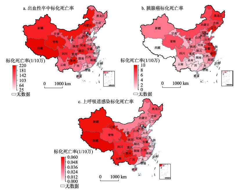
Chronic diseases are the main cause for death in the world. Among all risk factors concerning chronic diseases, those related to an unhealthy diet are most important. Although much research was done on dietary behavior, there are only few quantitative studies on the relationship between dietary taste and chronic diseases. In this article, a taste dataset of the major categories of Chinese cuisine is established based on crowdsourced data from Chinese recipe websites. For a quantitative analysis of people's taste in different regions, additionally the locations of restaurants by category (using their respective points of interest) are integrated. Using the software Geodetector, these regional taste preferences are then correlated with the three chronic diseases, hemorrhagic stroke, pancreatic cancer, and upper respiratory tract infection. For all the three diseases, the results indicate very salty, moderate sweet and very spicy food as the primary risk factors. Also, the degree of sweetness is not linear with the risk of pancreatic cancer. These results are statistically significant. In this study, a quantitative method on discovering potential health risk factors based on mining of crowdsourced data is proposed for the first time. This method can be applied before disease-related experiments to filter potential factors, and it is helpful for the public health department to make quick corresponding intervention policies.
Using the methods of textual analysis and in-depth interview, this paper investigates the discourse representation of Guangzhou-African populations and Guangzhou-African communities in Guangzhou newspaper in the past decade. The study finds that the early Guangzhou newspaper has established a clear, symbolic and stigmatized Afro-space map based on the newspaper's own requirements for news materials (e.g. the novelty) and the influence of local politics on newspaper practices. The earlier newspaper discourse has produced negative social influences and, to a certain extent, intensified the contradiction between African groups and local communities. Later, with changes in the macro-political pattern, especially in the context of building a socialist harmonious society and the China-Africa Cooperation Forum, the Guangzhou newspaper has devoted to the Guangzhou-African report to form a geographical imagination of the China-Africa Development Community and the positive image of Guangzhou-African populations and Guangzhou-African communities, with a view to reshaping the spatial meaning of Guangzhou-African communities. In view of this, we argue that the Guangzhou-African discourse in Guangzhou newspaper industry is a process of constructing the spatial image of the ethnic population and ethnic community, and thus becomes a geographical reproduction of the continuous projection, entanglement and change of local politics, national politics and international politics. In this sense, this study enriches the understanding of ethnic community demarcation, space production and geographical imagination from the perspective of socio-cultural geography and political geography, and attempts to establish a coupling geographical perspective between newspaper public opinion and geopolitics. From the practical perspective, this paper explores the challenges and influences of media discourse on the integration of cross-border culture in the context of globalization, which hence has a certain value for the integration and negotiation of Chinese and foreign multiculturalism and the realization of benign international interaction.
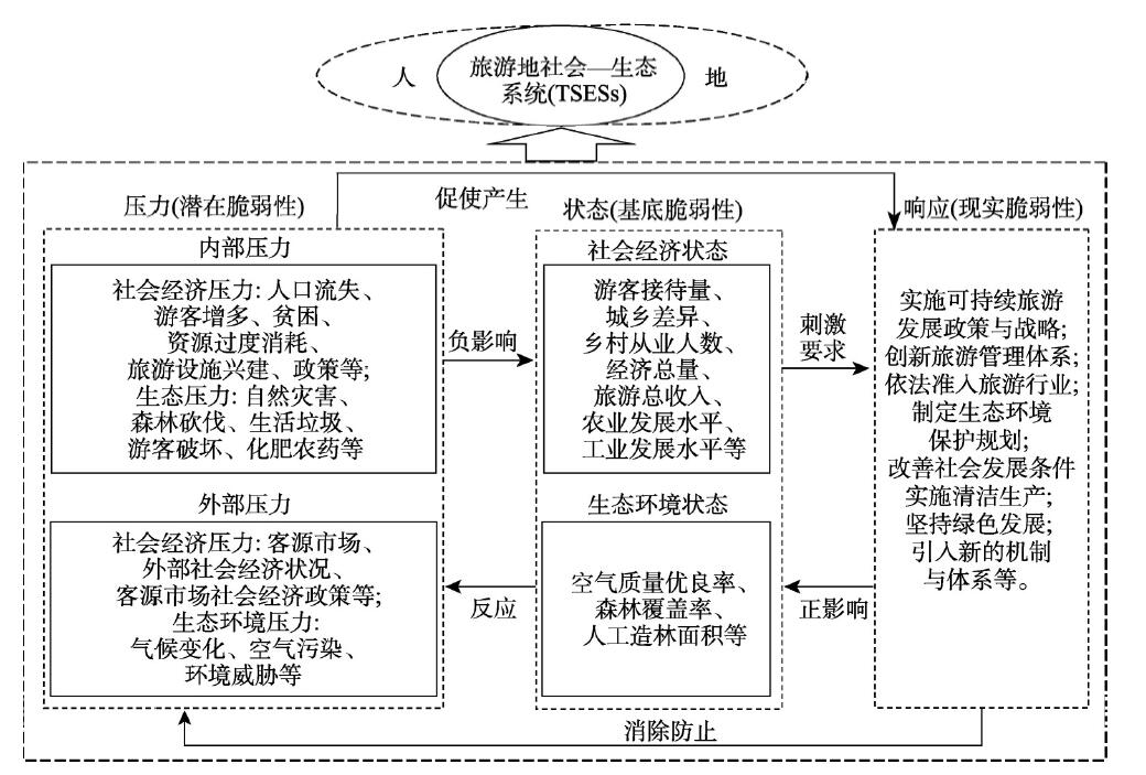
Tourism's socio-ecological vulnerability is mainly composed of social, economic, and ecological subsystems and the related changing elements from tourism development. It is an integrated manifestation of social vulnerability, economic vulnerability and ecological vulnerability. The paper, taking nine counties in the Dabie Mountain Area as case studies, proposes a socio-ecological vulnerability theoretical framework and comprehensive evaluation index combining the Social-Economic-Environment (SEE) model and the Pressure-State-Response (PSR) model. It explores the spatio-temporal evolution and mechanism that influences vulnerability in impoverished mountainous areas. Conclusions are drawn as follows: (1) During the period 2009-2016, the regional system vulnerability composite index fluctuated, declining from 0.52 to 0.41. The index for the economic subsystem continued to decline, and the index for the social and ecological subsystem kept stable. The contribution to a composite index for a regional system reached 76%, and the regional system had a relatively low degree of vulnerability and tended toward a positive direction. (2) The value of low vulnerability counties fluctuated and declined, and the coefficient of variation is lower, while the value of high vulnerability counties in 2013 began to decrease gradually and evolved into a lower degree of vulnerability; the coefficient of variation is larger. For the entire region, the spatial differences of vulnerability in the county experienced a wave-shaped dynamic change. Finally, the differences reached the minimum in 2013, which led to an aggravation of regional differences. (3) The main factors affecting tourism socio-ecological vulnerability have already changed from the growth of tourism income, the proportion of industrial added value in GDP, the urban-rural income gap, the proportion of tourism income to GDP, and the ratio of agricultural acreage to the density of the tourism economy and tourists, and the population urbanization rate. Entire regional vulnerability has already evolved from state-dominated to pressure-dominated.
The relational geography is conceived with the development of post-structuralism and "relational turn". From the perspective of relational geography, the world is understood as a topological structure of flowing while things are not considered as products of eidos ego but products of the relations. Relational thinking is counter-essentialized, it stresses on the dynamic, inter-dependent interactions between things. Through literature review, we find out the development relational geography is strong influenced by the social network and non-representational theory. The appearance of relational geography reconstructs the connotations of space, place, scale and subjectivity. We put forward the concept of relational space, place relations, multi-scale or the end of scale and the geographical inter-subjectivity. We construct the networking, relational and the flow of topological geography. The current empirical studies of the relational geography focus on the spatial diffusion and expansion, subject development, socio-cultural, bodily, tourist, health issues. Besides, we hope to offer new perspectives for Chinese human geographers based on the concepts of "human", "more-than-human", "things" and "re-materialization".

Prof. Chu Shaotang, who was a famous geographic educator and historical geographer, worked in the Department of Geography, East China Normal University. His thoughts of geography education set up the basic frame of geography education and research of primary and secondary schools in China. His efforts on starting academic organization and publication of geography education still play a great role. He compiled geography teaching syllabus and textbooks for primary and secondary schools which benefit generations. He also made contributions to the study of Shanghai's historical geography with unique views on urban development, land formation and water system change. His collation and proofread work on Xu Xiake's Travel Notes are epochal contributions, and he was a master on Xu Xiake's research. In addition, he also made contributions in the fields of urban geography, cartography, and literature translation.