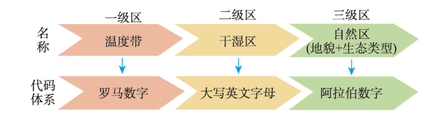
With the increasing global warming over the past three decades, the climatic zones and eco-geographical regions characteristics in China have changed. This study used the climatic data of 641 meteorological stations over the past three decades (1991-2020), as well as the high-precision data of eco-geographical elements to optimize the eco-geographical regions in China. The study updated the map of eco-geographical regionalization in China (2023) and increased the scale to 1:4000000. The new map divided China into 11 temperature zones, 22 dry and wet regions, and 50 natural regions. The results show that compared with eco-geographical regionalization in 2007, the overall pattern of eco-geographical regions in China has not changed significantly over the past three decades, but the boundaries of temperature zones, dry and wet regions, and eco-geographical regions (natural regions) in some areas have changed to some extent. Firstly, the boundary change of temperature zones is more obvious in the east. Particularly, in the middle and lower reaches of the Yangtze River, the northward shift of the temperature zone boundary between the northern subtropical and the mid-subtropical zones is obvious. Secondly, the boundary between dry and wet regions has changed, and that between semi-arid and arid regions in the north of the second-order landform step has shifted slightly to the west. In addition, the boundary between semi-arid and sub-humid regions in the Qinghai-Tibet Plateau has shifted slightly to the southeast, reflecting a slight expansion of the scope of semi-arid regions. Finally, boundary changes in natural regions in some areas vary greatly. This study can provide a macro-regional framework for guiding ecological conservation and restoration in different regions.
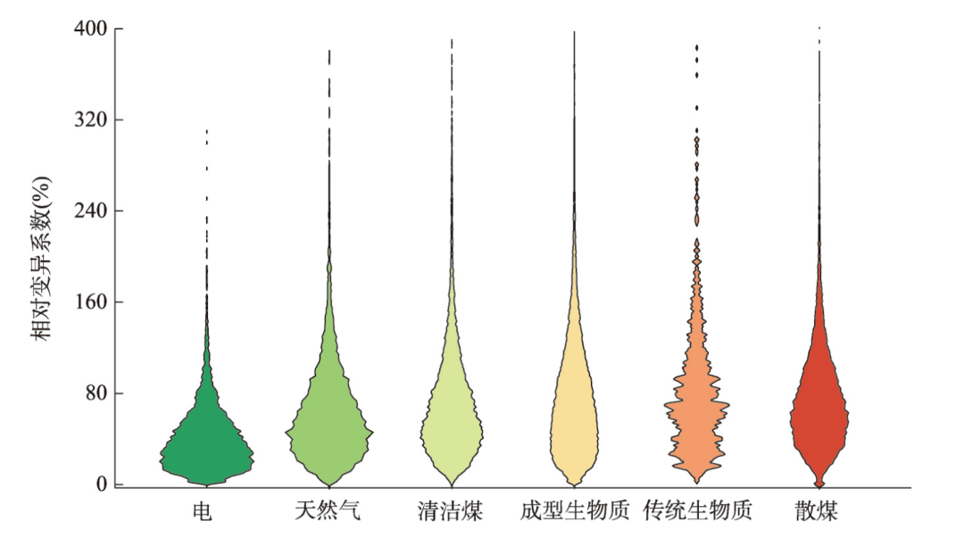
Indoor combustion of low-quality coal chunks significantly contributes to wintertime haze episodes and directly affects indoor air quality, posing high risks to human health. Besides electricity or gaseous fuels, clean coals and pelletized biofuels have been proposed as alternative fuels to reduce pollutant emissions associated with raw coal burning in some policies and pilot projects. However, there is still a lack of quantitative evaluation on real-world indoor air quality from homes using different heating fuels. This limits a comprehensive understanding of the environmental and health co-benefits of clean heating policy. In this study, indoor fine particulate matter (PM2.5) was measured from 1600 households located in rural north China. The aim was to assess indoor PM2.5 variations within and between different homes and attribute the pollution differences to heating types. The study found that the average indoor PM2.5 during the heating period was 102 μg/m3, but it varied greatly from 19 to 497 μg/m3. In the home burning traditional coals and biomass fuels, the indoor PM2.5 concentrations were as high as 162 μg/m3 and 144 μg/m3, respectively, while in the home using clean coals or biomass pellets, the indoor PM2.5 levels were significantly lower, at about 84 μg/m3, although this still exceeded the national standard (50 μg/m3) during more than 56% of the entire monitoring period. The lowest indoor PM2.5 levels were observed in the home using clean modern energies like electricity or gas for heating. Due to distinct human activity intensities and meteorological conditions, the indoor PM2.5 also varied greatly from day to day. The coefficient of variation (COV) in indoor PM2.5 from different days was approximately 76% in the home using solid fuels, while it averaged 53% in the home using clean energies. Internal combustion sources contributed to about 60% of indoor PM2.5 in the home burning traditional solid fuels. When switching to cleaner household energies, internal combustion emission contributions declined obviously. To lower indoor PM2.5 levels, low-quality dirty coals should be suspended and replaced by cleaner energies like pelletized biofuels or clean coals, and the most significant reduction would be achieved by switching from coals to electricity. The present study provides empirical evidence from first-hand observational data to enhance the understanding of indoor air pollution variability. It supports a comprehensive scientific evaluation of clean heating policy in terms of air pollution mitigation and human health protection.
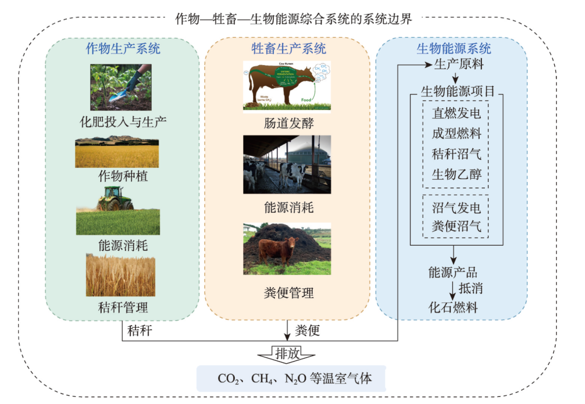
The utilization of surplus straw and manure derived from the crop and livestock production systems for bioenergy production presents a valuable approach to mitigate environmental pressures associated with the crop-livestock system, while concurrently addressing greenhouse gas emissions. This study establishes an integrated framework encompassing crops, livestock and bioenergy, and employs a life cycle assessment methodology to quantify the greenhouse gas emissions inventory across diverse processes within crop and livestock production systems at both national and provincial scales from 2010 to 2019. By comparing emissions and regional differentials between the integrated crop-livestock-bioenergy system and conventional system during distinct production phases. These findings shed light on the environmental impact of the integrated approach on agricultural emissions. The findings reveal that: (1) Notably, the baseline scenario identifies three key sources of agricultural greenhouse gas emissions: crop straw management, livestock enteric fermentation, and energy consumption in crop production, with notable regional variations. (2) Environmental impact intensity shows a fluctuating trend in most regions or provinces, with a pronounced decline (-0.73×10⁻²) observed in eastern China, while Xinjiang experiences the largest increase (0.63×10⁻²). (3) The abundant surplus straw and manure in these systems present a significant opportunity. The integrated system demonstrates a remarkable ability to mitigate agricultural greenhouse gas emissions, potentially cutting nationwide environmental impacts by up to 67% at its maximum.
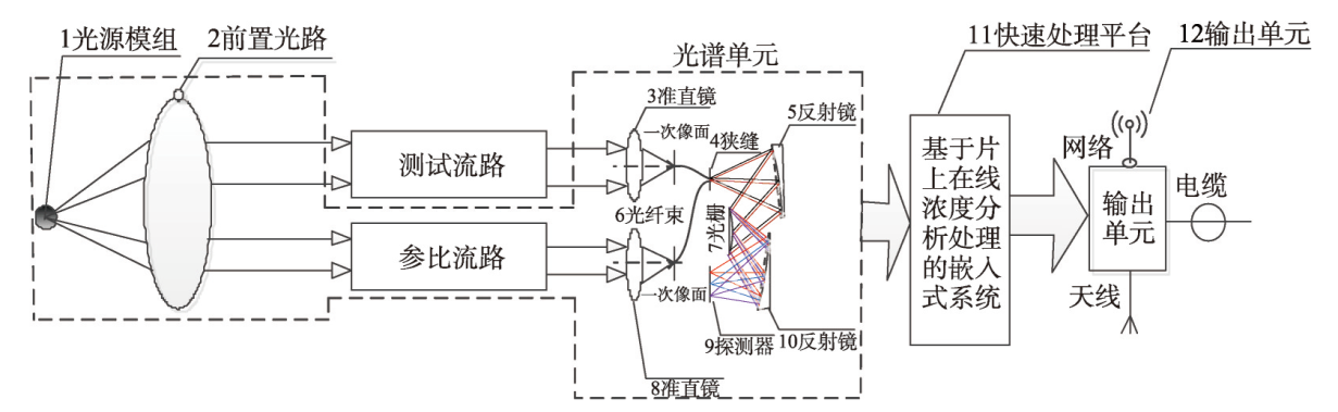
Water eco-environment monitoring is the premise and foundation of habitat protection. In view of the characteristics of the Yangtze River Basin's water system, which is diverse, complex, and ever-changing, higher requirements are put forward for monitoring methods. At present, the water quality monitoring methods for large surface water systems are still mainly based on manual sampling combined with laboratory chemical analysis or on-site hand-held instrumental analysis. There are problems such as method lag, single means, low frequency, and lack of non-point sources. Therefore, there is an urgent need for new system monitoring technology, which breaks through real-time, fast, non-point source quantitative and other practical needs, and provides a reliable data source for the comprehensive simulation of the Yangtze River water system. In this context, this paper proposes a fine spectral detection and quantitative analysis technology with completely independent intellectual property rights, and develops ground-based, space-based and other system technologies and equipment. With the support of the relevant projects, the demonstration application of systematic technology was carried out, and the space-ground stereoscopic monitoring was conducted in the key sections of the main stream of the Yangtze River, the Three Gorges Demonstration Area and the Poyang Lake Demonstration Area, and good results were achieved. The monitoring data are connected to the "Yangtze River Simulator" through the cloud platform, which provides fast real-time data support for its comprehensive operation, as well as a new method and application model for the comprehensive monitoring of large-scale water systems in the future.
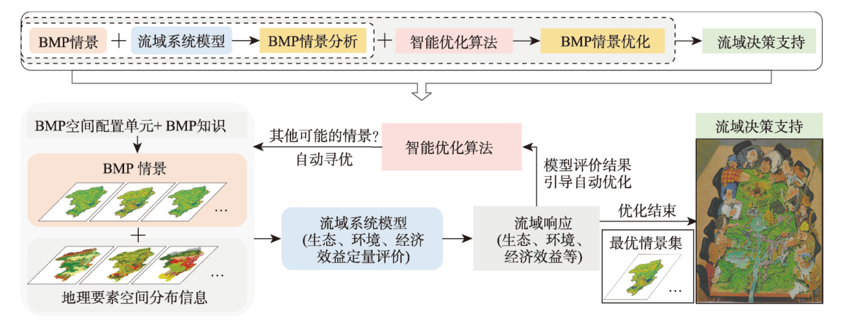
The construction of China's ecological civilization, known as "Beautiful China", necessitates implementing precision watershed management through scientifically informed decision-making. This entails optimizing the spatial distribution of watershed best management practices (the so-called BMP scenario) and proposing multistage implementation plans, or roadmaps that align with practical requirements based on the overarching vision of comprehensive watershed management. The "watershed system simulation-scenario optimization" method framework (the simulation-and-optimization-based framework for short) has demonstrated considerable potential in recent years. To address challenges arising from practical applications of this framework, this study systematically conducted the methodological research: (1) proposing a novel watershed process modeling framework that strikes a balance between modeling flexibility and high-performance computing to model and simulate watershed systems efficiently; (2) introducing slope position units as BMP configuration units and enabling dynamic boundary adjustments during scenario optimization, effectively incorporating practical knowledge of watershed management to ensure reasonable outcomes; (3) presenting an optimization method for determining the implementation orders of BMPs that considers stepwise investment constraints, thereby recommending feasible roadmaps that meet practical needs; and (4) designing a user-friendly participatory watershed planning system to facilitate collaborative decision-making among stakeholders. The effectiveness and practical value of these new methods, tools, and prototype systems are validated through application cases in a representative small watershed. This research contributes to advancing precision watershed management and provides valuable insights for sustainable ecological conservation. The methods proposed within the simulation-and-optimization-based framework in this study are universal methods, which means their application does not depend on the specific implementation, such as the watershed process model, the BMP types considered, the designed BMP configuration strategy, and so on. Further studies should be conducted not only to deepen related theory and method research but also to strengthen promotion and application, especially cooperating with local watershed management agents to provide valuable insights for their sustainable ecological conservation.
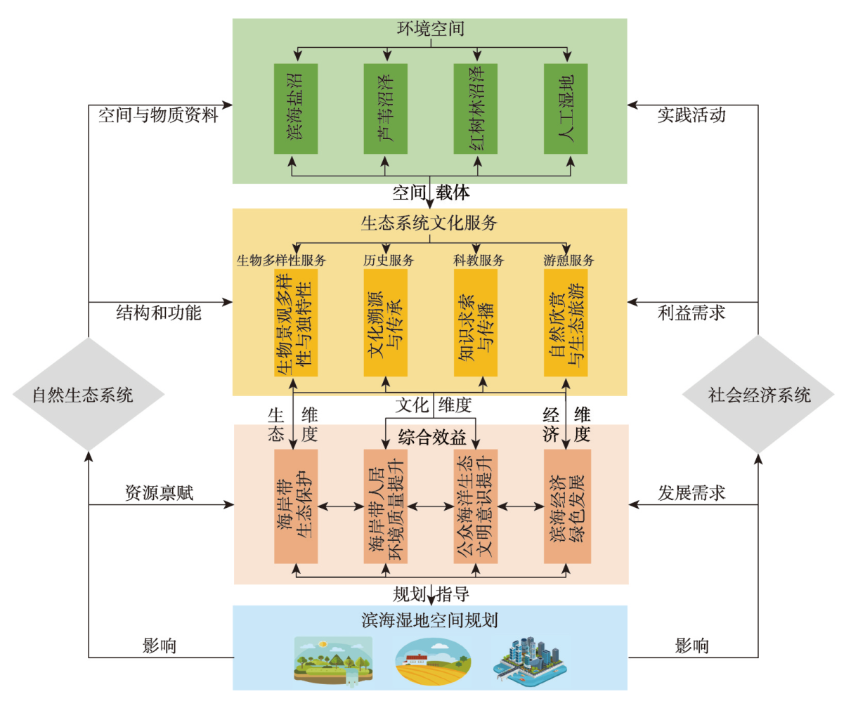
Coastal wetlands, a pivotal realm of sea-land interactions, exhibit profound ecological sensitivity. Increasingly shifting climatic patterns and intensifying anthropogenic interventions pose formidable challenges to the sustainable utilization of these invaluable assets. Cultural ecosystem services (CESs) represent a subtle, yet crucial conduit connecting the natural environment and human society, thereby playing a pivotal role in the holistic management of coastal and oceanic domains. This study employed the theoretical framework of CESs involvement in the sustainable management of coastal wetland resources, and integrated multi-sourced social media data with the MaxEnt model to conduct an empirical investigation focused on nine Chinese coastal wetlands which are listed in Ramsar Convention. The results reveal the following: (1) From the mean level of each CES, the coastal wetlands with the strongest capacity for biodiversity, historical, educational, and recreational service respectively was the Guangxi Shankou Mangrove Wetland (0.222), with a high level area of 61.218 km2, accounting for 27%; Fujian Zhangjiangkou Mangrove Wetland (0.336), with a high level of 9.037 km2, accounting for 17%; Tianjin Beidagang Wetland (0.092), with a high level of 70.981 km2, accounting for 11%; and Fujian Zhangjiangkou Mangrove Wetland (0.350), with a high level of 9.037 km2, accounting for 17%. (2) Delineating the spatial differentiation pattern of each CES, the high-level zone for biodiversity service in Shankou Mangrove Wetland is predominantly clustered within the eastern and central regions. A high level of historical service was more significant in the western and eastern Fujian Zhangjiangkou Mangrove Wetland. Regarding educational service in the Tianjin Beidagang Wetland, high-level areas were clustered in the western sector. The high-level recreational service areas of the Zhangjiangkou Mangrove Wetland were mainly clustered in estuarine area. (3) Assessing the contributions of environmental variables to CESs, it became evident that distance to nature reserves, land-use type, and distance to bird habitats emerged as the principal factors steering the divergences in biodiversity service patterns. Simultaneously, distance to infrastructure, roads, and bird habitat proximity significantly influenced the historical, educational, and recreational services within the nine coastal wetlands, albeit to varying extents. (4) In line with both regional and national strategies, this study categorised sustainable resource management approaches for the nine coastal wetlands into three distinct modes: ecological restoration, ecological and cultural rejuvenation, and ecological and industrial integration, thereby presenting innovative paradigms for the research and implementation of comprehensive governance within China's coastal and oceanic domains.
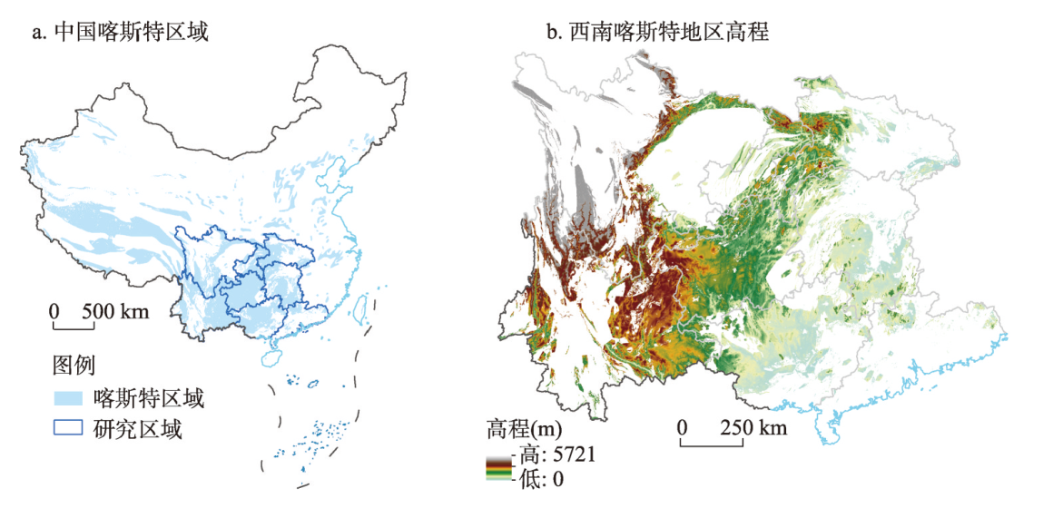
Ecological restoration measures have a significant impact on biodiversity hotspots. Therefore, quantifying the contribution of desertification control to biodiversity is crucial in the karst region of southwest China. This study employed regression analysis and residual trend analysis to reveal the evolutionary patterns of desertification and biodiversity from 2000 to 2020 in this region. It quantified the contributions of desertification control and other factors to biodiversity. The results indicated that during the study period, desertification in the karst region was mainly classified as mild and moderate levels, with a total area reduction of 102500 km2 at an annual rate of 4900 km2/a. Overall, biodiversity showed an increasing trend, with a mean value of the biodiversity composite index at 0.40, maintaining a moderate level. There was a positive correlation between desertification control and biodiversity, with desertification control contributing 26.39% of the overall impact. Climate change and human activities contributed 52.78% and 47.22% to biodiversity, respectively. This suggests that desertification control has made a positive contribution to biodiversity and provides valuable guidance for future ecological restoration projects and biodiversity conservation.
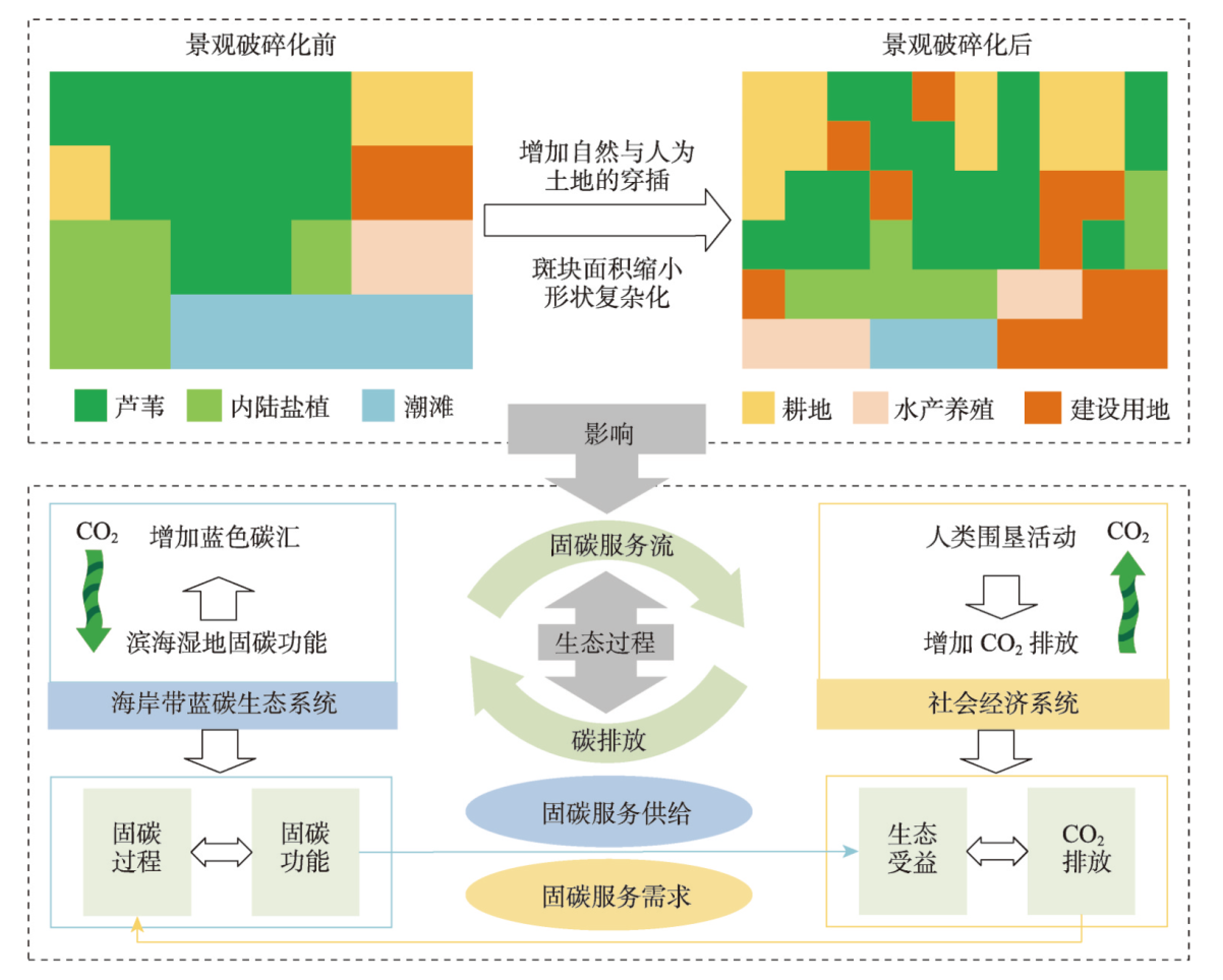
As one of the long-term solutions to the global climate change problem, the harmonious dynamic relationship between supply and demand of blue carbon is of great significance in promoting regional carbon balance and sustainable management. With the rapid socio-economic development, the landscape fragmentation of the coastal zone is significant, which directly affects the ecological processes such as energy flow and material circulation in its system. However, the effects of coastal zone landscape fragmentation on the supply-demand relationship and flow of carbon sequestration services are not clear. Based on the framework of the impact of coastal landscape fragmentation on carbon sequestration service flow, this study synthesizes land use data, carbon storage sampling data and nighttime light data, and employs the moving window method, the InVEST model and the network model to conduct an empirical study in the Liaohe River Delta, a typical silty coastal zone in northern China. The results show that: (1) From 1995 to 2020, with the intensification of landscape fragmentation in the Liaohe River Delta, the demand for carbon sequestration services increased by 30.44 million tons and the supply of carbon sequestration services increased and then decreased, with the overall change being insignificant, and the difference between the supply and demand of carbon sequestration services increased from 4.49 million tons in 1995 to 33.76 million tons in 2020. (2) The negative impact of landscape fragmentation on the carbon sequestration service flow varied among different anthropogenic intensity, with more pronounced impact on agricultural reclamation areas, increasing and then decreasing impact on industrial port reclamation areas, while little impact on reed wetlands. (3) The impact of landscape fragmentation on the spatial pattern of carbon sequestration service flow is reflected in the density and connectivity of carbon sequestration service flow network, interrupting service flow and changing the direction of service flow. (4) The reed protection areas and agricultural reclamation areas have important ecological functions, and ecological red line should be strictly controlled to enhance carbon sequestration capacity. The industrial port reclamation areas should strengthen the construction of ecological corridors to enhance landscape connectivity and restore carbon sink function. This study reveals the relationship between landscape fragmentation and carbon sequestration service flow, and the results can provide scientific basis and management reference for ecological restoration and carbon sequestration capacity enhancement in China's conservation strategic key areas and other similar silt coastal zones around the world.
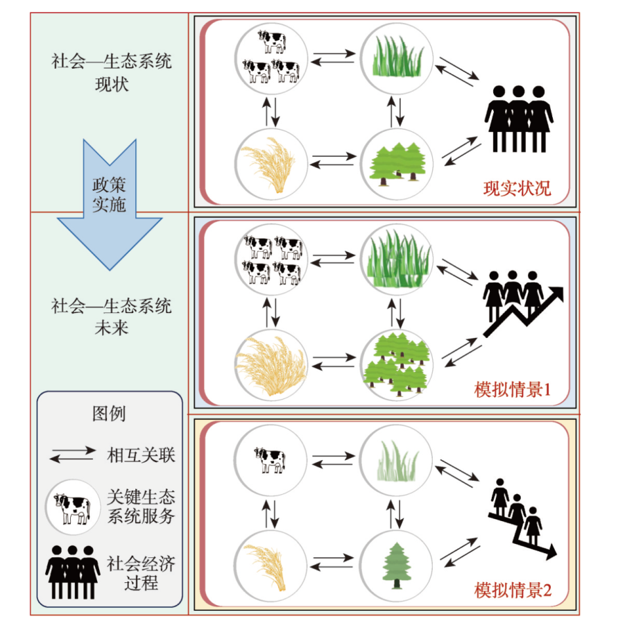
Social-Ecological System (SES) is a collection of social subsystems, ecological subsystems, and the interactions between them. It is a common difficulty of cross-multidisciplinary fields to predict the changes in human-earth systems and support the relevant management decisions through clarifying the interaction between the ecological environment and human society. The framework of ecosystem service provides a new perspective for revealing the transmission and the role of various elements in SES. Taking ecosystem service as an entry point, this study follows the context of "Ecological System Supply-Ecological Coupling Human Intervention-Promoting Social Development". And the research progress and trends of existing coupling simulation methods related to SES are summarized. This article argues that in the conduction research of the ecosystem services cascade, the academic cognition has emphasized the "impact of natural ecosystem to social-economic system" rather than the "interaction and feedback mechanisms for ecosystems and social systems". In terms of research content, scholars have trsnsformed their focus from "changes in ecosystems and environmental effects" to "social-economic system and the effect on different groups". The focus of research has shifted from the theoretical inquiry of the "internal mechanism and power mechanism" to the applied practice of "optimization and regulation strategy" among the coupling systems. Future research of SES should strengthen the simulation of social-ecological coupling with equal emphasis on nature and humanities. It is the focus of breakthroughs to comprehensively understand the internal interactions and feedback of complex systems.
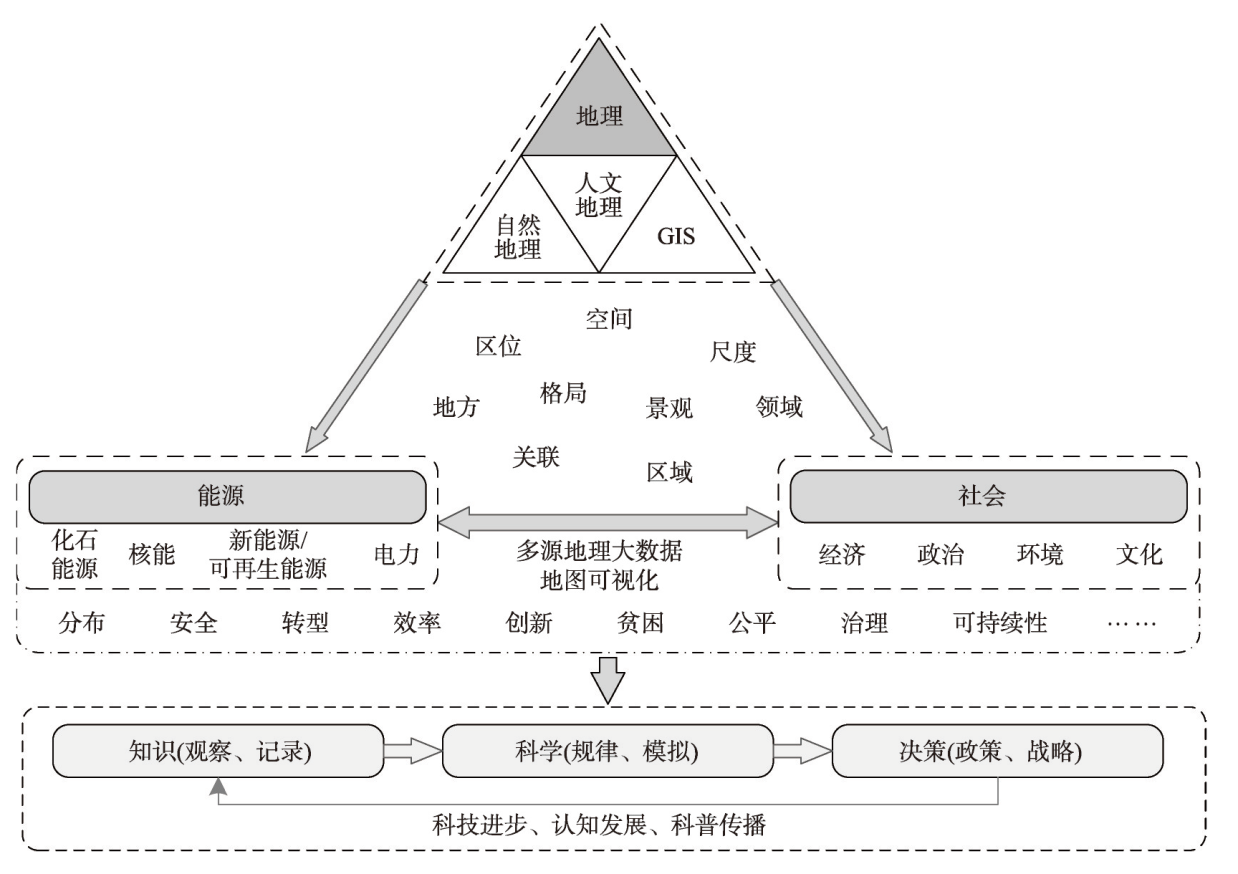
The interaction between the energy system and human society is the main focus of energy geography research, encompassing multiple dimensions such as economy, politics, environment, and culture. The uneven distribution and spatial flow of energy, as well as its environmental effects, have attracted the attention of geographers, who can also analyze energy issues through unique perspectives and research methods. The study of energy geographies has emerged due to economic activities and geopolitics in the energy system on the earth's surface and has entered a new prosperous stage due to the challenge of global climate change and discussions on social equity. Due to the different stages of development, energy and environmental issues, and academic atmospheres between China and foreign countries, scholars have different focuses on perspectives and research characteristics. Foreign energy geography research started from the study of resource distribution and economic geography, and has gradually formed an academic community under the traction of energy and environmental issues. In the long-term development process, diverse research topics such as energy production networks and energy flows, energy geopolitics and energy security, energy transitions and climate governance, energy justice and energy poverty have emerged, which can provide many useful references for Chinese scholars. Since the mid-20th century, China's research on energy geographies has roughly formed the tradition of "world resource geography" and "sectoral economic geography", and has continued to carry out practical application research based on national strategic needs. Since the beginning of the 21st century, research on carbon emissions and residential energy consumption has gradually been in line with international standards. In recent years, under the background of emphasizing the carbon peaking and neutrality goals, energy transition, and energy security, energy geography has ushered in new development opportunities. However, there are also internal and external challenges. To build the subject of "energy geography", we need to make innovations in theory and methods, consultation and think tank research, popular science communication, and talent team construction based on inheriting valuable traditions.
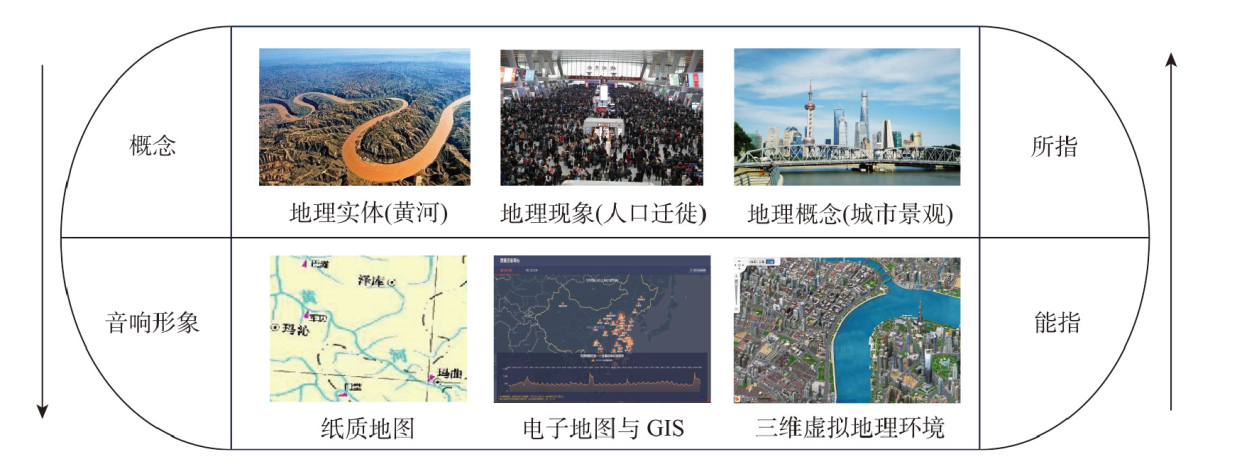
As the second language of geography, maps have similar structure, function, and property to the natural language. The linguistic mechanisms of the map symbol are the focus of the previous map language research, however, the connotation and characteristics of the map language are still hardly studied from the perspective of geography. Additionally, with the development of information technology and the advent of the big data era, the concept of "pan-map" has been proposed and further developed, which brings noticeable changes and new features to the forms and contents of the map representation. Firstly, we analyzed the linguistic connotation of geographical language based on linguistic theory and indicates that, from the perspective of geography, the concept of map language should be shifted from the linguistics of map symbol to the entire map system. Then, we further examined the linguistic connotations of map, and elucidated the concept generalization of the modern map language, specifically, the concept generalization of the "signifier: and "signified". Next, from the perspective of geographical language, we explored the phonetic, semantic, and syntactic structures of map, along with the evolutionary characteristics of language structures during the map evolution process. Finally, we analyzed the meta-functions of map language by analogy with the concept of meta-functions in linguistics, that is ideational function, interpersonal function, and textual function. We also found the new characteristics of functional aspects that emerge during the map evolution, including new features manifested by maps in terms of information carrying, information dissemination, cognitive and simulation function. From the perspective of linguistics, we studied the geographic language property of the map and its evolution, which deepens the understanding of the language mechanisms of maps and offer a new paradigm for research in geographic linguistics.
The geo-computational social sciences (GSS) has emerged as a new frontier in the interdisciplinary fields. However, the GSS has somehow trapped into a predicament as the field evolves, due to many fundamental theoretical issues remaining unsettled, such as the underlying theoretical legitimacy, conceptual domains, and research paradigm. Aiming to rectify these fundamental flaws, this paper first traces the evolving and intersecting trajectories of sociology, geography and geographical information science and focuses on the spatial turn and ideological trend of computationalism, based on which the theoretical legitimacy of GSS is defended. Second, we crystalize its conceptual domains with reference to Deleuze's conceptualization of Rhizome and further unfold the conceptual domains from two perspectives. Third, in reference to Kuhn's paradigm framework, we clarify the research paradigm of GSS through a systematic theoretical deduction from three aspects, i.e., epistemology, ontology and methodology. Finally, we propose the research agenda for GSS against China's context in the post-pandemic era to advance the theoretical innovations and applications of modern geography.
Rapid urbanization has profoundly altered soil carbon cycling and thereby reshaped the spatial pattern of soil carbon content and fractions across the urban-rural gradients. In this study, we measured the contents of total carbon and its different fractions in the topsoil (surface layer 0-10 cm and subsurface layer 10-20 cm) of twenty parks across four urban-rural transects in Beijing, China. We analyzed the spatial variations of different soil carbon fractions and their potential driving factors across the urban-rural gradients. The results showed that topsoil total carbon (topsoil: 21.0±1.6 g/kg; subsurface soil: 18.0±1.3 g/kg) was dominated by organic carbon (topsoil: 64.6%±4.5%; subsurface soil: 54.9%±4.5%). Topsoil contents of organic carbon showed a nonlinear trend from the urban core to the rural area, while the topsoil inorganic carbon content decreased significantly. Topsoil organic carbon (topsoil: 13.8±1.5 g/kg; subsurface soil: 10.0±1.2 g/kg) was dominated by particulate organic carbon (topsoil: 71.3%±2.4%; subsurface soil: 70.5%±2.9%). The contents of both particulate organic carbon and mineral associated organic carbon showed nonlinear changes across the urban-rural forest transects. The proportion of particulate organic carbon was relatively low in urban areas, while that of mineral associated organic carbon showed an opposite trend. Soil texture, soil pH, and park age were important drivers to shape the spatial variation of topsoil carbon components across the urban-rural transects, while the urban-rural climate gradient and species diversity were found to have an unimportant role. Our findings improve the understanding of how urbanization reshapes soil carbon fractions and have useful implications for soil management in urban forests.
Soil moisture is a key driving factor that affects vegetation growth. Vegetation reacts to soil moisture through processes such as evapotranspiration. In-depth exploration of the interaction between soil moisture and vegetation GPP is crucial to ensuring the sustainable development of ecosystems and the efficient utilization of water resources. This study employed MODIS GPP, ERA5-Land soil moisture, and other data sources. It utilized an enhanced nonlinear Granger causality model, along with partial correlation analysis, Sen's slope, and the Mann-Kendall method. These methods were used to examine the combined changes in GPP and soil moisture and their mutual feedback relationship across diverse vegetation types in China from 2000 to 2021. The results showed that: (1) Since 2000, 50.89%-57.61% of the vegetated areas in China have shown a synergistic trend of increasing GPP and decreasing soil moisture, which exhibited a greater proportion with increasing soil depth. The proportion of areas with consistently increasing trends in both GPP and soil moisture was 39.03%-45.76%. (2) In 59.88%-79.38% of vegetated areas, both GPP and soil moisture showed a bidirectional Granger causal relationship. This proportion decreased with soil depth, notably in temperate grassland areas (R6) and temperate desert regions (R7). (3) The increase in GPP resulted in a more significant consumption (57.03%) of soil moisture at 100-289 cm depth and a longer lag effect (2.15 months). Soil moisture at a depth of less than 100 cm mainly promoted the increase in GPP (71.43%-76.58%) and only showed inhibitory effects in some areas, such as the Tianshan Mountains and Hengduan Mountains. The promoting effect of soil moisture at 100-289 cm depth on the vegetation GPP (48.31%) weakened and was accompanied by a significant increase in the lag effect (2.92 months). (4) As the precipitation increased, the interaction between vegetation GPP and soil moisture gradually decreased. When the precipitation was between 200 mm and 400 mm, the interaction was most significant. The influence of different temperature gradients on the interaction between vegetation GPP and soil moisture exhibited multiple threshold effects. This study helps to deepen our understanding of the interaction between carbon and the water cycle of the terrestrial ecosystem in the context of climate change. It also provides an important theoretical reference for the implementation of future ecological restoration projects and the sustainable development of ecosystems.
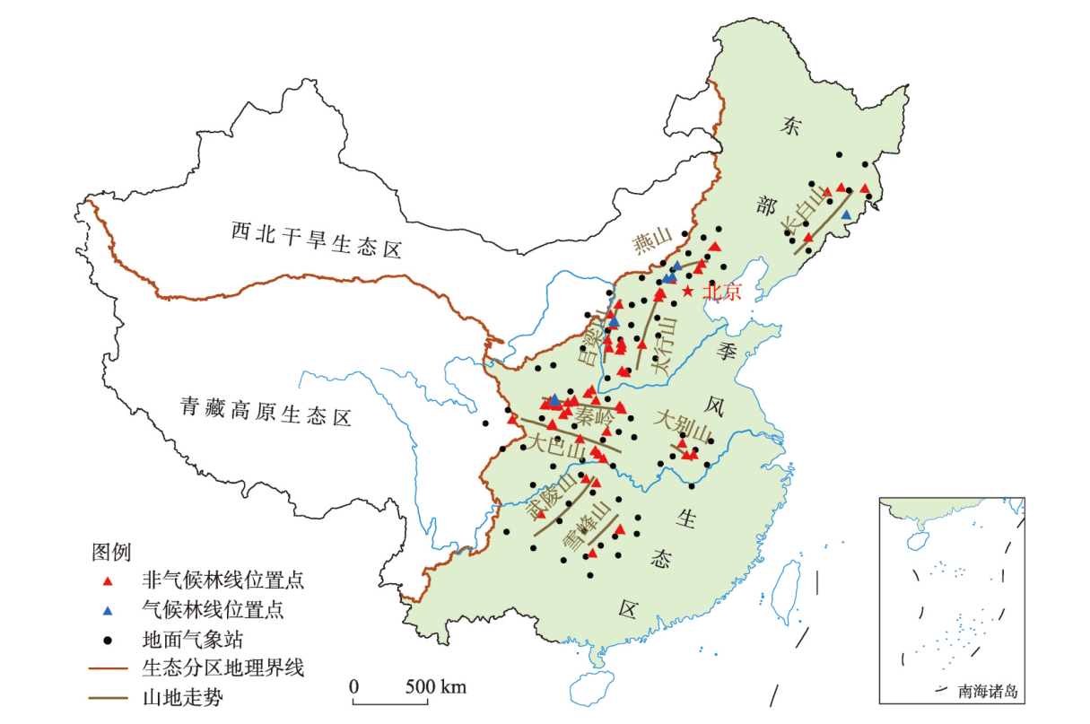
The deciduous broad-leaved forests are a typical vegetation in the eastern monsoon region of China. This work utilizes the fine classification data of surface cover of composite elevation information to extract the upper limit of montane deciduous broad-leaved forests. We examine the distribution characteristics of the upper limit and its factors influencing the montane deciduous broad-leaved forests by constructing cloud models of the upper limit height. Moreover, this work constructs multiple linear regression models (with the upper limit of deciduous broad-leaved forests at multiple scales (regional, mountain, and local) as the dependent variable and the influencing factors as the independent variables), and a weight coefficient cloud model of influencing factors. Furthermore, this work compares and analyzes the scale changes and spatial differences of the effect of influencing factors on the upper limit of deciduous broad-leaved forests. The sensitivity differences of different montane deciduous broad-leaved forest upper limits to climate factors are also explored. Results show that: (1) The upper limit height of the deciduous broad-leaved forest in the eastern monsoon region of China first increases and then decreases from north to south. The expectation (Ex), entropy (En), and hyper entropy (He) of the distribution height cloud model are 965.77-1993.52 m, 132.80-514.09 m, and 27.58-205.34 m, respectively. (2) Significant scale changes can be observed in the impact mechanism of the upper limit of deciduous broad-leaved forests in the mountainous areas: at the regional scale, the dominant factor for non-climatic and climatic forest lines is mountain base elevation, with contribution rates of 71.36% and 44.06%, respectively. The climatic forest line is more affected by temperature than by precipitation. Meanwhile, non-climatic forest line is more affected by precipitation than by temperature. At the mountain scale, the upper limit of deciduous broad-leaved forests in the mountainous areas is mainly influenced by January average temperature and annual precipitation, and the role of January average temperature in most mountainous areas is larger than that of annual precipitation. On a local scale, except for the Dabie Mountains, the mountaintop effect has the highest weight on the upper limit of deciduous broad-leaved forests in each mountainous area (Ex: 44.84%-68.15%). In addition, the expectation weight of annual precipitation (Ex: 15.45%-41.86%) is higher than that of the January average temperature (Ex: 4.3%-9.97%). (3) The deciduous broad-leaved forests in the Dabie Mountains and Taihang Mountains are most sensitive to annual precipitation (Ex: 40.24% and 18.95%; He: 0.96% and 1.89%). Lvliang Mountains are the most sensitive to January average temperature (Ex: 8.31%; He: 1.09%). Exploring the spatial distribution characteristics and influencing factors of the upper limit of deciduous broad-leaved forests in the mountainous areas can promote the study of differences in altitudinal belt response to climate change and provide theoretical support for the construction and management of regional ecological security monitoring systems.
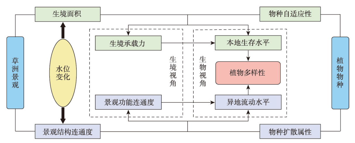
With the acceleration of global landscape fragmentation, it is of great significance to reveal the impacts of landscape connectivity on biodiversity in order to restore ecological process and protect biodiversity. Taking the grassland of Poyang Lake as research object and from the integrated perspective of combined water level change and species dispersal, this study firstly analyzed the dynamics of grassland structural and functional connectivity respectively after identifying the distribution pattern of grassland at different water levels using landscape pattern indices and the graph-based connectivity indices. Then, the effects of grassland connectivity on plant diversity and the scale effects were discovered by means of the linear regression model. Moreover, the multiple stepwise linear regression model was applied to compare the relative explanatory power of structural and functional connectivity to plant diversity pattern. The results are shown as follows: (1) The grassland in Poyang Lake exhibits a landscape characteristic of "expanding when water falls while shrinking when water rises". It faces both inundation and segmentation effects of water with water level change, and its shrinkage always coexists with landscape fragmentation. (2) With the increase of water level, the area of grassland patch continues to shrink, the shape tends to be simple, the density reduces, and the fragmentation intensifies, resulting in a decrease of grassland structural connectivity. Meanwhile, the number of components increases, the probability of connectivity reduces, so that grassland functional connectivity decreases significantly. (3) The higher the connectivity of grassland, the higher the richness of plant species at the landscape scale, and the higher the similarity of plant communities at the patch scale. Functional connectivity is more effective in explaining plant diversity pattern than structural connectivity does. This study can provide some references for landscape pattern optimization and plant diversity conservation in lake areas from a new perspective of landscape connectivity.